Research on Rapid 3D Modeling of Airport Navigation Facilities based on Oblique Photography Technology
←
→
Page content transcription
If your browser does not render page correctly, please read the page content below

IOP Conference Series: Earth and Environmental Science

PAPER • OPEN ACCESS

Research on Rapid 3D Modeling of Airport Navigation Facilities based
on Oblique Photography Technology
To cite this article: Ziya Zhang et al 2021 IOP Conf. Ser.: Earth Environ. Sci. 693 012095

View the article online for updates and enhancements.

                              This content was downloaded from IP address 178.171.25.129 on 26/03/2021 at 12:46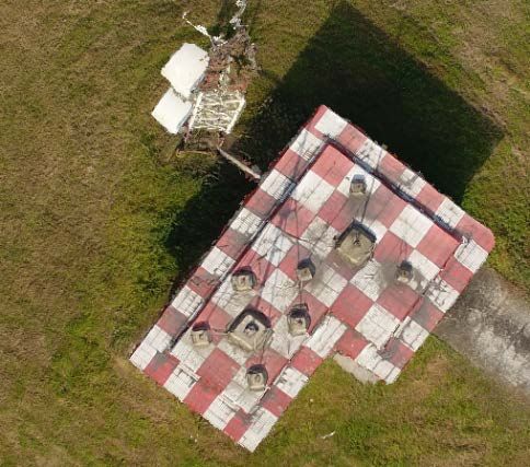
8th Annual International Conference on Geo-Spatial Knowledge and Intelligence               IOP Publishing
IOP Conf. Series: Earth and Environmental Science 693 (2021) 012095     doi:10.1088/1755-1315/693/1/012095

Research on Rapid 3D Modeling of Airport Navigation
Facilities based on Oblique Photography Technology

                     Ziya Zhang*, Weijun Pan, Junjie Zhou and Qiyang Zhang
                     Department of Air Management, Civil Aviation Flight University of China, No. 46, Se
                     ction 4, Nanchang Road, Guanghan City, Sichuan Province, China.
                     Email:398168980@qq.com*

                     Abstract. With its short time-consuming, high-precision, and low-cost characteristics, Oblique
                     photography technology has been widely used in surveying, remote sensing, and other fields.
                     Due to the airport usually has airplanes in operation, it is difficult to obtain aerial images of
                     airports, especially for antennas and other facilities that require relatively high modeling
                     accuracy. This paper takes the airport Instrument Landing System(ILS) glideslope, a complex
                     building with antennas, as an example, to carry out the research on the rapid modeling of a single
                     camera with free-photo-control-point based on Oblique photography. First, to obtain a complete,
                     high-resolution aerial image of the ILS glideslope, plan the path of the Unmanned Aerial Vehicle
                     (UAV) photography, determine the flight height, flight radius, and other parameters; Secondly,
                     improve the 3D airport model by adding orthophotos. Finally, by comparing the accuracy of the
                     3D modeling of the two sets of different parameters, obtain a strategy suitable for rapid modeling.
                     The study shows that the proposed method can complete the high-precision 3D reconstruction of
                     the airport's complex navigation facilities in a short time.

1. Introduction
Oblique photogrammetry technology is one of the products of the modern technology era. Oblique
photography can observe objects from multiple angles and have an outstanding advantage in 3D
reconstruction in real scenes[5]. Since cities have accelerated the construction of "digital cities" and
"smart communities" in recent years, the importance of oblique photography, which can quickly create
3D modeling, has been highlighted.
    The airport has a large number of indication and navigation facilities. These facilities are often
equipped with complex objects such as antennas that can send and receive signals. Traditional
photogrammetry technology is difficult to accurately obtain the texture information of the objects. Using
oblique photography can obtain clearer texture information of the object from multiple angles. The 3D
modeling of the airport is convenient for the digital management and evaluation of the airport in the
future[1]. However, since there are aircrafts in the airport area for 24 hours, It is difficult for UAV to take
aerial photography for a long time within the airport. So whether rapid 3D modeling is possible becomes
the key.
    Based on the oblique photography technology, this paper focuses on the rapid 3D modeling method
of the airport ILS glideslope. The airport ILS glideslope is a complex building with antennas, it requires
higher modeling accuracy, Because of its representativeness, this study takes it as the research target. In
this study, take aerial photos of ILS glideslope with different flight radius and flight height. Based on the
aerial images obtained by different strategies, 3D models of the airport ILS glideslope were constructed
respectively. After comparison and analysis, determining the flight parameters suitable for 3D modeling
of the ILS glideslope.

              Content from this work may be used under the terms of the Creative Commons Attribution 3.0 licence. Any further distribution
              of this work must maintain attribution to the author(s) and the title of the work, journal citation and DOI.
Published under licence by IOP Publishing Ltd                          1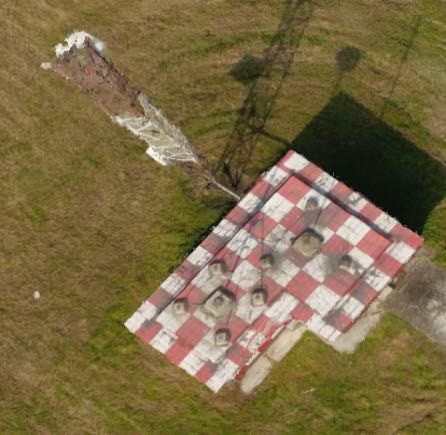
8th Annual International Conference on Geo-Spatial Knowledge and Intelligence               IOP Publishing
IOP Conf. Series: Earth and Environmental Science 693 (2021) 012095     doi:10.1088/1755-1315/693/1/012095

2. Rapid 3D Modeling of Airport Navigation Facilities
Airports play a very important role in both the military and civilian fields. The 3D modeling of the
airport not only helps to improve human-computer interaction, but also greatly helps flight simulation
training, airport land management, and virtual reality. Airports usually have planes operating day and
night, which brings difficulties to the use of oblique photography technology to obtain airport aerial
images. Therefore, the study of rapid airport 3D modeling methods has important research and practical
significance.

2.1. Advantages of Oblique Photography
Oblique photography can collect data from vertical and multiple oblique directions to better show the
side texture of the building, and it can also use positioning technology to embed accurate geographic
information in the modeling, which can more realistically show the airport navigation location
information of the facility. The oblique photography technology does not have too many site
requirements for the take-off location. It can shoot a large amount of images and obtain a large amount
of data. The data production time is short, the modeling efficiency and authenticity are high, and it is
very suitable for quickly obtain data and perform 3D modeling[4].

2.2. Photo Selection
Because the oblique photography technology can acquire a large number of images, the denser the
images shot in the same range, the greater the overlap rate, the more matching points, and the easier
automatic matching. When the overlap is less than 60%, the geometric deformation caused by the
height difference will be more serious, but too many images will increase in modeling costs, cost, for
example, it will affect the running speed of the later 3D reconstruction.
    For 3D modeling of oblique photography, the general fore-and-aft overlap is between 60% and 80%
to ensure the accuracy of the picture. The calculation formula for the heading overlap rate is as follows:
                                                    px
                                               =
                                            px %       ×%                                               (1)
                                                    lx
   among them lx is the photo length, px is the overlap length of the two photos. In order to speed up
the 3D modeling time, while ensuring the overlap rate is more than 70%, the first photo is retained for
every five photos and the other four photos are deleted, The model of the 3D model before and after the
photo is deleted is as follows:

                            (a)                                             (b)
                  Figure 1. (a) 3D model before deleting; (b) 3D model after deleting

   It can be seen that there is almost no difference between before and after deleting, but it took 4 hours,
34 minutes and 35 seconds before deleting the images, and 1 hour, 29 minutes and 50 seconds after the
deleting, which greatly shortened the time.

                                                      2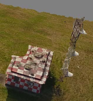
8th Annual International Conference on Geo-Spatial Knowledge and Intelligence               IOP Publishing
IOP Conf. Series: Earth and Environmental Science 693 (2021) 012095     doi:10.1088/1755-1315/693/1/012095

3. Experiment Content

3.1. Data Preparation
In this experiment, an airport navigation facility--ILS glideslope is used as the research target to carry
out rapid 3D modeling research for airport navigation facilities. The glide slope is generally located on
the side of the entrance of the airport runway and consists of a computer room and maker beacon
antennas. The radiation field generated by the beacon antenna forms a sliding surface and forms a
certain angle with the ground. The glide beacon is used to generate a vertical guidance signal for the
aircraft to deviate from the glide surface.
    In this experiment, DJI Phantom 4pro was used in an airport to obtain experimental data of ILS
glideslope. The airport runway is 2,200 meters long and 45 meters wide. The ILS glideslope is located
on the right side of the runway center line, 120 meters from the runway center line, and 200 meters from
the runway entrance. The airport photography area is 0.013 square kilometers. The ILS glideslope is
shown in Figure 2:

                                     Figure 2. The ILS glideslope

   The flowchart of this experiment is shown in Figure 3:

                                   Figure 3. Experimental flowchart

3.2. Image Capture
The images were captured by a rotary wing with four rotors, DJI Phantom 4 Pro UAV. This equipment
has a navigation system that uses GPS and GLONASS. In addition, it is equipped with front, rear, and
lower vision systems that allow it to detect surfaces with defined patterns and adequate lighting and
avoid obstacles with a range between 0.2 and 7 m[2].
   The camera carried by DJI Phantom 4pro is DJIFC330, with an effective pixel of 20 million, a
camera focal length of 4 mm. The resolution of the photos taken in this experiment is 4000*3000, the
horizontal resolution is 72dpi, and the vertical resolution is 72dpi. Since DJI Phantom 4pro has only one
lens, this experiment first obtained the oblique images of the ILS glideslope, adjusted the angle of the

                                                     3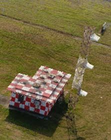
8th Annual International Conference on Geo-Spatial Knowledge and Intelligence               IOP Publishing
IOP Conf. Series: Earth and Environmental Science 693 (2021) 012095     doi:10.1088/1755-1315/693/1/012095

cradle head, and then obtained the orthophoto of the ILS glideslope. The oblique images is obtained by
the pan-tilt rotation 45o, and the orthophoto is obtained by the pan-tilt vertically downward.
    This experiment uses the a3 flight control system that comes with DJI Phantom 4pro to control the
drone shooting. Before shooting, set the fore-and-aft overlap rate to 80%, The oblique images of the ILS
glideslope is completed by the point of interest surround mode in the a3 flight control system. Taking the
ILS glideslope as the point of interest, set the flight radius and flight height according to the different
flight parameters of the two experiments.The first experiment was that the flight radius was 71 meters,
the flight height was 30 meters, and the second experiment was that the flight radius was 25 meters and
the flight height was 24. Meters, using automatic continuous shooting mode to take photos. As listed in
the following table:

                                        Table 1. Experimental data.
         Modeling objects         Experiment name           Flying height (m)         Flight radius (m)
          ILS glideslope           Experiment 1                    30                         71
                                   Experiment 2                    24                         25

    The altitude in aerial surveying and mapping is divided into absolute altitude and relative altitude.
Absolute flight altitude is the altitude relative to the average sea level, and relative flight altitude is the
altitude of the aircraft relative to the reference plane. During drone aerial photography operations, the
camera acquires discrete pixels, the ground sampling interval (GSD) is often used to calculate the
altitude. Generally, in order to adapt to the GSD required by the experimental accuracy, the camera
object distance needs to be controlled to control the altitude. The calculation formula for the relative
altitude H is:
                                            H= f × GSD / a                                                 (2)
    Where H is the relative altitude, f is the focal length, GSD is the ground sampling interval of the
image, and a is the pixel size. The DJI Phantom 4pro used in this experiment can directly display the
relative altitude without additional calculation.
    The airport ILS glideslope is a complex building with antennas, and the traditional oblique
photographic snake-shaped flight line is easy to cause flight blind spots. In this experiment, the
surrounding flight path was used to photograph the airport ILS glideslope. If the surrounding radius is
too large, the image will be unclear, and the final 3D model will be less accurate. If the surrounding
radius is too small, there will be blind areas, the texture of the object part cannot be obtained, and the
final 3D model will have holes. This experiment uses two different flight radius with the ILS glideslope
of an airport as the origin, adds a route to shoot orthophotos, and compares the 3D modeling accuracy
under two different parameters.

                            (a)                                                 (b)
                 Figure 4. (a) Experiment 1 route design; (b) Experiment 2 route design

                                                       4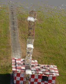
8th Annual International Conference on Geo-Spatial Knowledge and Intelligence IOP Publishing
IOP Conf. Series: Earth and Environmental Science 693 (2021) 012095 doi:10.1088/1755-1315/693/1/012095
3.3. Image Processing
The experiment were executed using Agisoft Metashape Professional software version 1.4.5, This
software is a 3D scanning software developed by the Russian Agisoft company and based on the SfM
algorithm. In this experiment, only the airport ILS glideslope is modeled without control points, and the
scope is small[2]. Using Metashapes software can quickly process the image and realize the rapid 3D
modeling of the airport ILS glideslope. Data processing has the following four steps:
1) Import the captured images to the computer, check the quality of the captured photos and sort them
according to different height radius.
2) Open the Metashape software and select the add module to prepare for importing photos, then
enter the workflow module, add photos, and import the photos.
3) Then enter the second step of the workflow to align the photos. The Metashape software will
automatically arrange the photos according to the image's latitude and longitude coordinates, height
information, similarity, etc. The accuracy of the alignment photos in this experiment select medium.
4) Then enter the third step of the workflow to generate dense point clouds. The selection accuracy of
this step is also medium, generate meshes, generate textures and finally get a 3D model.
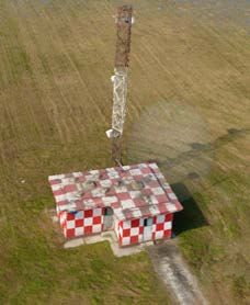
3.4. Experimental Results
In this experiment, a total of two groups were flown, and two sets of models were built through the
Metashape software. Figure 5 and Figure 6 show the modeling effects of the front, side, and back three
directions of the ILS glideslope in the two experiments:
(a) (b) (c)
Figure 5. Experiment 1 (a) front image;(b) side image; (c) after influence
(a) (b) (c)
Figure 6. Experiment 2 (a) front image;(b) side image; (c) after influence
4. Conclusion
From the comparison of the models built in the two experiments, it is concluded that the square console
and the antenna part under the sliding platform modeled in Experiment 1, and the antenna and the
console below can also be modeled in Experiment 2.The texture of the antenna modeled in Experiment 1
5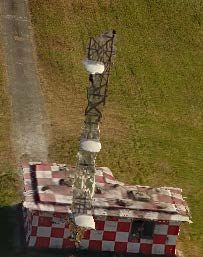
8th Annual International Conference on Geo-Spatial Knowledge and Intelligence               IOP Publishing
IOP Conf. Series: Earth and Environmental Science 693 (2021) 012095     doi:10.1088/1755-1315/693/1/012095

is a bit clear and deformed, while the comparatively restored facts built in Experiment 2 seem to have
relatively flat lines and a relatively small difference from the original picture.
    No matter whether Experiment 1 or Experiment 2 compares the modeled color with the original data,
there is no big difference, but the color of Experiment 1 is still a little darker than the original photo, and
the color of the grass is thicker and compared with the original yellow-green The drop is not big, and the
color of experiment 2 is closer to the color of the original photo, and the yellow and green patches of the
grass are more obvious.
    In summary. In Experiment 2, the 3D model built by the drone with a flying height of 24 meters and
a flying radius of 25 meters has a better effect. The antenna and other facilities can also be clearly seen in
the middle.

5. References
[1] Patricio Martínez-Carricondo, Francisco Agüera-Vega, Fernando Carvajal-Ramírez. Use of
     UAV-Photogrammetry for Quasi-Vertical Wall Surveying[J]. Remote Sensing, 2020, 12(14).
[2] Xujie Zhang, Pengcheng Zhao, Qingwu Hu, Mingyao Ai, Datian Hu, Jiayuan Li. A UAV-based
     panoramic oblique photogrammetry (POP) approach using spherical projection[J]. ISPRS
     Journal of Photogrammetry and Remote Sensing, 2020, 159.
[3] I. Aicardi, F. Chiabrando, N. Grasso, A. M. Lingua, F. Noardo, A. Spanò. UAV
     PHOTOGRAMMETRY WITH OBLIQUE IMAGES: FIRST ANALYSIS ON DATA
     ACQUISITION AND PROCESSING[J]. ISPRS - International Archives of the Photogrammetry,
     Remote Sensing and Spatial Information Sciences, 2016, XLI-B1.
[4] A. Murtiyoso, F. Remondino, E. Rupnik, F. Nex, P. Grussenmeyer. Oblique Aerial Photography
     Tool for Building Inspection and Damage Assessment[J]. ISPRS - International Archives of the
     Photogrammetry, Remote Sensing and Spatial Information Sciences, 2014, XL-1(1).

                                                       6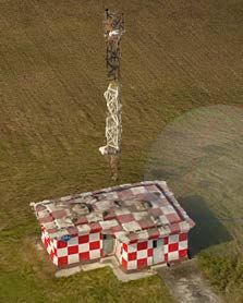
You can also read


