REPUBLIC OF THE MARSHALL ISLANDS TYPHOONS - Hawaii Sea Grant
←
→
Page content transcription
If your browser does not render page correctly, please read the page content below

HOMEOWNER’S HANDBOOK TO PREPARE FOR NATURAL HAZARDS
                                                                                     REPUBLIC OF THE MARSHALL ISLANDS
TYPHOONS   TSUNAMIS

                                                                               By
                                                                               Don Hess
                                                                               Dennis Hwang
                                                                               Karl Fellenius
                                                                               Ian Robertson
                                                                               Mark Stege
                                                                               Ben Chutaro

                      UH SEA GRANT

DROUGHT    FLOODING
Acknowledgements                                                                         Additional UH Sea Grant Publications
   This handbook would have not been possible without the generous support of numerous individuals
   that include: Darren Lerner, Darren Okimoto, Dolan Eversole, Heather Dudock, and Cindy
                                                                                                                                           Erosion and coastal inundation are serious issues for atoll
   Knapman (UH Sea Grant); Thomas Armbruster and Norman Barth (U.S. Embassy); Dan Dieckhaus                                                nations. A Landowner’s Guide to Coastal Protection offers
   (USAID); Jennifer de Brum (Office of the Chief Secretary); Antonio Eliu (RMI National Disaster                                          straightforward advice on how coastal communities can
   Management Office); Reginald White and Lee Jacklick (RMI National Weather Service Office);                                              assess coastal hazards and reduce risk. The guide is written
   Charles Guard (Guam Weather Forecast Office); Bart Deemer, Isaac Marty, Junior Lather, William                                          specifically to help people in the Marshall Islands make
   Reiher, and Richard Muller (College of the Marshall Islands); Mark Lander (UOG); Melissa                                                informed development choices. However, the approach applies
   Iwamato, Martin Guiles, Douglas Luther, and Fiona Langenberger (PacIOOS); Melvin Dacillo                                                to any coastal settlement where waves, wind, and water
   and Winfredo Mendez (RMI Ministry of Public Works); Mark Adams, Angela Saunders, Christian                                              converge to impact homes, livelihoods, and safety.
   Oakes, and Tim Langrine (International Organization for Migration); Zed Zedkaia (USDA); Biram
   Stege (Assumption School); Dr. Alex Pinano, Hemina Nysta, Telbi Jason, and Paul Alee (Marshall
   Islands Red Cross Society); Jina David (CMI Land Grant); Kanchi Hosia, Cassiano Jetnil, and
   Catalino Kijner (RMI Ministry of Education); Jerry Kramer, Kenneth Kramer, David Kramer, and
   Bobby Muller (Pacific International, Inc.); Tracy Spear and Larry Hernandez (Majuro Do-it-Best);
   Yuichi Yamaguchi (Majuro Ace Hardware); Ben Chutaro (BCI); and Tim Waite and Steve Zanco
   (Simpson Strong-Tie). We are sure there may be others that we have missed but it is not intentional
   and we acknowledge all of those who help make this book possible.

   The Homeowner’s Handbook to Prepare for Natural Hazards: Marshall Islands was modeled after
   the original Homeowners Handbook to Prepare for Natural Hazards by Dennis Hwang and Darren
                                                                                                         The Hawaiÿi Homeowner’s Handbook to Prepare for Natural
   Okimoto of the University of Hawai‘i Sea Grant College Program (UH Sea Grant). A special thanks       Hazards provides useful tips regarding readiness for natural
   goes to UH Sea Grant Communications for providing the graphics template used in preparation of        hazards that may affect Hawaiÿi, including tsunami and
   this guidebook.                                                                                       hurricanes. The handbook lists local civil defense and emergency
                                                                                                         management agency information, as well as emergency shelter
   It is our hope that the information contained within the handbook, which is in part a compilation     locations.
   from numerous publications associated with natural hazards and hazard mitigation, will be widely
   used and adopted by stakeholders in the Marshall Islands and the region.                              The third edition includes four new appendices that address
                                                                                                         installing storm panel screws, reroofing, securing photovoltaic
   Financial support for the handbook was generously provided by the University of Hawai‘i Sea
                                                                                                         systems, and ways to get involved with community resilience
   Grant College Program through the Coastal Storms Small Grants Program and USAID whom we
   gratefully thank.
                                                                                                         efforts.

                                                                                                                                  To order copies of these publications, contact:

                                                                                                                                University of Hawai‘i Sea Grant College Program
                                                                                                                                       c/o College of the Marshall Islands
                                                                                                                                                 P.O. Box 1258
                                                                                                                                               Majuro, MH 96960
                                                                                                                                        Republic of the Marshall Islands
 Marshall Islands
                                                                                                                                             (692) 625-3394 ext 221
Red Cross Society                                                                                                                        email: uhsgcomm@hawaii.edu

                                                                                                                                   http://seagrant.soest.hawaii.edu/publications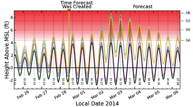
REPUBLIC OF THE MARSHALL ISLANDS

               By
            Don Hess
          Dennis Hwang
          Karl Fellenius
          Ian Robertson
           Mark Stege
           Ben Chutaro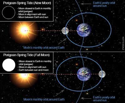
CONTENTS
PART 1 INTRODUCTION                                            1
1.1 Common Myths and Reasons to Prepare                        2
1.2 Ten Things You Can Do to Prepare                           5

PART 2 NATURAL HAZARDS: AN OVERVIEW FOR HOMEOWNERS             7
2.1 Tropical Cyclones                                          7
2.2 Tsunami Hazards in the Marshall Islands                   13
2.3 Extratropical Storms                                      15
2.4 King Tides                                                18
2.5 Sea-Level Rise                                            20
2.6 Erosion                                                   21
2.7 Drought                                                   23

PART 3 PROTECTING YOURSELF AND YOUR FAMILY                    24
3.1 Emergency Supplies                                        24
3.2 Evacuation Kit                                            26
3.3 Evacuation Planning                                       28
     3.3.1 Ten Criteria for Ideal Emergency Shelter           28
     3.3.2 Shelters on Majuro                                 36

PART 4 PROTECTING THE HOME                                    44
4.1 The Roof Structure and Protection from High Winds and Rain 44
     4.1.1 Tying the Wood Top Plate to the Concrete Structural
		Bond Beam                                                    46
     4.1.2 Tying the Truss to the Wood Plate or Concrete Beam  47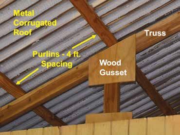
4.1.3 Fortifying the Trusses                     50
      4.1.4 The Truss-Purlin Connection                51
      4.1.5 Fastening the Roof to the Purlins          52
4.2 Protecting Windows from High Wind and Debris       55
4.3 Protection from Termites and Corrosion             59
      4.3.1 Best Practices to Prevent Corrosion        59
      4.3.2 Best Practices to Prevent Termite Damage   61
4.4 Protection from Wave Inundation and Flooding       64
      4.4.1 Flood Damage Resistant Materials           64
      4.4.2 Elevation of Houses                        66
4.5 Rainwater Catchment Systems                        70
4.6 Land Management on Your Property                   74
4.7 Mentors                                            76

RESOURCES                                              77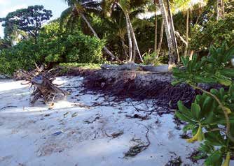
PART 1
                                      INTRODUCTION
When a natural hazard occurs - whether it be a tropical cyclone, tsunami, extratropical storm,
king tide, flood, sea-level rise, erosion, or drought - the results can be devastating for your
land, your home, your family, and your possessions. Financial losses can be particularly high
in the two administrative centers of the northern and southern Marshall Islands - Majuro
and Ebeye, Kwajalein - which have seen explosive growth in both population and land area
since the mid-1940s. This has been especially true in Majuro, where a number of lagoonal
openings along Majuro Atoll were connected by the US Navy to form the single 30 mile strip
of land that today is home to over half of the Marshall Islands population (see Figure 1-1).
Adding to the island’s horizontal growth, seawalls have become a common feature on Majuro
covering over 30 percent of eastern Majuro’s shoreline (McKenzie, 2006). As a result, the area
comprising Delap-Uliga-Djarrit and the Amata Kabua International Airport built in 1967 - has
grown by 170 acres or about 40 percent due to engineering (Ford, 2011). With this aggregation
of people and development in Ebeye, Kwajalein, and eastern Majuro especially, Marshall
Islanders and their homes have become increasingly exposed to potentially dangerous natural
hazards.

This handbook was created to help you prepare for a natural hazard so that risks to the family
and property may be reduced. While it is never possible to eliminate all damage from a natural
hazard, you as a homeowner can take action and implement many small and cost-effective
steps that could significantly lower your risk. Mother Nature can be intense. Your family
deserves the protection that only you can provide.

    Figure 1-1. Lagoonal openings in D.U.D. were closed in 1944, followed by rapid development. (Images
    Courtesy of Marshall Islands Visitors Authority and D. Hwang)

                                                  1
This handbook is divided into four parts. This introduction presents the purpose and layout
of the handbook, and includes a discussion of common myths that may have prevented you
from taking action in the past. A summary of the contents of this handbook is also provided in
the form of 10 action items. Part 2 provides basic information on tropical cyclones, tsunamis,
extratropical storms, King Tides, floods, sea-level rise, erosion, and drought that will allow
you to make an educated decision about the steps to take to protect your family and property.
Part 3 discusses in detail how to protect yourself and your family. Included in this section are
the stock of essential emergency supplies, evacuation kit, evacuation planning, evacuation
procedures, and important information that the national and local emergency management
agencies and organizations want you to know even before they issue a warning. Part 4 covers
how you can protect your property. Many examples are provided.

This handbook is available for free as a downloadable pdf file at the University of Hawai‘i Sea
Grant College Program website:
http://seagrant.soest.hawaii.edu/homeowners-handbook-prepare-natural-hazards-RMI
It will be updated on an as-needed basis as new information becomes available and feedback
from the public is obtained. The handbook will be available in Marshallese in late 2015.

              1.1 COMMON MYTHS AND REASONS TO PREPARE
You may be among most homeowners in the Marshall Islands who have not fully prepared
for dealing with natural hazards because of complacency caused by several myths. The most
commonly quoted myths are discussed below in order to remove some of the major barriers to
taking action and to encourage people to prepare.

1) “A natural hazard cannot happen to me.” Scientists agree that it is not a matter
   of IF the next typhoon or tsunami will occur, but WHEN. Typhoon Bavi on March 11, 2015
   caused extensive damage on Ebeye, and the Marshall Islands experienced edge effects
   from Typhoon Pam, Maysak, and Dolphin between March and May 2015. Extratropical
   wave inundations have occurred regularly over the last few years, with significant damage
   on Majuro, Arno, and Mili on March 3, 2014. Going further back in time there were major
   wave inundations in 1979 and 2008, with devastating typhoons and loss of life in 1905 and
   1918. The Marshall Islands has been relatively fortunate in the last few decades, although
   there is a good chance you will experience a major event in your lifetime. Mild to moderate
   wave inundations every few months, some that are intensified by King Tides, are important
   reminders that the islands are very vulnerable to even the slightest flooding.

2) “If a hazard occurs, it will not be that bad.” When a tsunami or typhoon occurs,
   the damage can be devastating. The 1918 Typhoon caused 200 people to lose their lives out
   of a Majuro population of 1,100 at the time. Imagine the potential loss of life if a typhoon
   of the same intensity occurred today, with a Majuro population of 28,000.

                                           2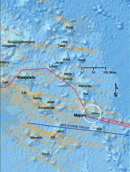
3) “I have a stronger house than my neighbor so I am sufficiently prepared.”
   Many people compare their level of preparedness against others in the community as
   opposed to addressing the level of preparation needed to adequately address hazard risk.

4) “Typhoons only hit the northwestern Marshall Islands so those on other
   islands do not need to prepare.” It is a myth that only Ujelang and Enewetak atolls
   are at risk for typhoons. While the northwestern Marshall Islands are closer to the
   Micronesian Typhoon Track - other cyclonic and extratropical storms have hit the
   other atolls at various points in history. Also, there have been many close misses, both
   historically and recently.

5) “Tsunamis do not affect atolls because they are surrounded by deep
   water, so I am safe.” While the wave will not gradually ‘feel’ the bottom and build-up
   as high as in areas with continental shelves, it will cross over the atolls at a full speed of
   several hundred miles an hour. Anyone caught on the first floor or outside during such an
   event may be washed out to sea, with higher risk if it occurs at high tide than at low tide.

6) “Installing typhoon clips does not guarantee there will be no damage
   during a typhoon, so I will not bother.” Even though someone may wear a seat
   belt there is no guarantee that they will not be injured in an automobile accident. Yet most
   people recognize the importance of these safety devices in reducing risk and use them.
   Likewise, the measures discussed in this handbook could significantly reduce risk, although
   there are no guarantees there will be no damage.

7) “If a natural hazard occurs, the government will come to the rescue.”
   After the March 3, 2014 extratropical wave inundation event, Marshall Islanders found
   that the government will not repair their damaged houses or provide any compensation
   for property damage. It is up to you to plan properly, strengthen your house, and carry
   insurance if available. After a natural hazard, the government may be overwhelmed by the
   number of people in need.

8) “My house survived the March 3, 2014 wave inundation, so I do not need
   to retrofit for extratropical wave inundations.” While this wave inundation
   was the most significant in recent years, it was mild in comparison to the likely effects of
   a typhoon or tsunami. Extratropical wave inundations may submerge ground floors by a
   few feet and cause some structural damage, but typhoons and tsunamis have the potential
   of submerging everything below the second floor and destroying all but the strongest
   buildings.

                                                3
9) “Droughts only affect the northern Marshall Islands, so I do not need to
   worry.” The 2013 drought affected only the northern atolls and their 6,000 inhabitants.
    But this does not mean that the next drought will be limited by the same geography. In
    fact, the drought expected for late 2015/early 2016 will likely be regional, affecting all of
    the Marshall Islands and beyond.

10) “Even if a hazard occurs, there is nothing I can do.” Many people pray and
    are therefore hopeful that a hazard will not befall them. Others think positively and
    believe that it has some effect on the outcome. While everyone’s beliefs should be
    respected, they should not be used as substitute for preparation. Fortunately, there are
    many small steps you can take to significantly reduce the risk of damage to life and
    property. The number of options available to homeowners has never been greater. While
    it is not possible to eliminate all risk or damage, many reasonable steps as described in
    this handbook to plan and prepare can make a major difference between life and death
    and determines whether a house survives or receives only minor or no damage. Thus,
    the information in this handbook covers two major parts for preparation: (i) protecting
    yourself and your family, and (ii) protecting your property.

11) “Strengthening my house is too expensive and not worth the effort.”
    Here are various cost-effective ways to strengthen your house:

    • Adding typhoon clips or window coverings offers significant protection alone and runs
      on the order of a few thousand dollars. Strengthening a roof structure (trusses and
      rafters) with bracing can be done at a minimal cost.
    • While strengthening an existing roof can be expensive, consider doing so when you are
      ready to replace it with a new roof as the additional cost is far more reasonable. Many
      homeowners who install solar photovoltaic panels reroof beforehand and this is a good
      time to strengthen the roof.
    • Upgrading the house foundation can be expensive but may be well worth it, especially
      if your house is your major investment.

    Ultimately, the time and money spent to prepare your house in order to minimize damage
    from a natural hazard are just a tiny fraction of what you might have to spend if major
    damages to your house occur as a result of a failure to take preventative measures. By
    preparing and strengthening your house, you may be able to wait out the hazard rather
    than evacuate to a shelter. Evacuation to a shelter should be the last resort, unless a
    typhoon or tsunami is approaching. There will be minimal supplies, the simplest of
    sanitary facilities, a bare floor, and little space (max. 10 square feet per person - 5 feet by
    2 feet). You will have to bring your own supplies including bedding, medication, food,
    and water. By remaining at home during a mild to moderate hazard, you will be in far

                                            4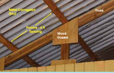
more comfortable conditions and have the ability to take better care of family members,
    including the elderly, those with special needs, and pets. Whether you can shelter in
    place will depend on numerous factors including your original house design, the retrofits
    you install, the strength of the hazard event, and if you are in one of the vulnerable areas
    prone to wave inundation. Nevertheless, by strengthening your house you protect your
    neighbors as well as yourself. A house that falls apart during a typhoon will create wind
    and water-borne debris that can damage adjacent properties.

                   1.2 TEN THINGS YOU CAN DO TO PREPARE
As covered in later parts of this handbook, here are 10 things you can do to prepare that will
provide greater protection for your family and property.

1) Gather your emergency supplies now. The good news is many items you need
   are probably in your home already (see Part 3). Check and restock each month so that
   the supplies are complete, not outdated, or used. Expiration dates, which are hard to read
   because of small print, can be made more visible on the packaging with a permanent
   marker. Avoid rushing to a store during an emergency to gather your supplies. There will be
   long lines and empty shelves - you will only add to the crowd and confusion.

2) Compile your evacuation kit. If your evacuation plans include using a shelter for
   a typhoon, you will need an evacuation kit that contains water, food, clothing, medications,
   personal hygiene products, and other items for up to five to seven days. The kit should
   already be assembled and checked before typhoon season (see Part 3). If the kit will be
   used during evacuation for shorter period hazards such as tsunamis and extratropical wave
   inundations, three days may suffice.

3) Create an evacuation plan for both an extra tropical wave inundation and
   a typhoon/tsunami. They are different. For an extratropical wave inundation your
   plan may include sheltering in your house if it is: (i) sufficiently strong (i.e., built with
   strong connectors, see #6) and (ii) outside of vulnerable areas that have repeatedly flooded
   in the past. If you cannot use your house, use a suitable alternative structure (a friend or
   relative’s house) or a shelter that is officially open [listen to local radio and television (see
   Part 3)]. For a typhoon/tsunami your plan is likely to be sheltering in one of the official
   shelters. There is no high ground in the Marshall Islands to escape to for tsunamis. If you
   have access to a good boat and can get into deep water on the ocean side quickly (not the
   lagoon) then this is the best option for a tsunami. Note that a tsunami may have several
   waves, so ensure the event is over before returning to land. Discuss, refresh, and practice
   drills of your evacuation plan with your family each year.

                                                 5
4) Know your property and take appropriate action. Look at where you are
located. If trees overhang your house, consider trimming or cutting the branches overhead
which may damage your house in a storm. By identifying the characteristics of your house
you can help determine the most effective measures to strengthen the structure (see Part 4).
5) Know your house and take appropriate action. When was your house built?
Does it have connectors to tie the roof to the wall or the wall to the foundation? When will
you need to reroof? Look at your blueprints, if they are available (see Part 4).
6) Strengthen your house. Some houses may have typhoon clips to tie the roof to the
wall, and strong connectors from the wall to the foundation. If your house was not built
this way, you can still retrofit parts of the house at a reasonable cost. All households should
consider the many options now available to protect your windows and doors. You can also
strengthen your roof when it is time to reroof. The steps a homeowner can take will vary
with each house, but for the majority of homeowners, there are a few steps that can make a
significant difference (see Part 4).
7) Insurance. Do not gamble with your house. Obtain adequate insurance if it is available,
and make sure to read any fine print.
8) Take advantage of potential discounts for your natural disaster insurance
premiums. Coverage may vary among insurance companies, and significant discounts
in your premium may be provided for reducing the risk to your house with window
protection, roof-to-wall tie-downs, and wall-to-foundation tie-downs.
9) Finance creatively. Consider efforts to strengthen your house as your most important
home improvement project. Most projects are not that expensive. For the more costly ones,
a small home improvement loan and potential discounts from natural disaster insurance
premiums make these projects within reach. It is a great investment to strengthen your
house and provide more protection for your family (see Part 4).
10) Seek the assistance of a qualified, licensed architect, structural engineer,
or contractor. This handbook covers work that you may be able to do yourself. If you
cannot do the work, seek qualified assistance through trusted references from friends and
family, emergency management agencies and organizations, or the individual contractors
on-island. Even if you do the work yourself, it is always best to seek professional advice
from a qualified architect, engineer, or building contractor. For simple tasks, ask your local
hardware stores for initial guidance since every house is a little different (see Part 4).
6PART 2
NATURAL HAZARDS: AN OVERVIEW FOR HOMEOWNERS
This part of the Handbook covers the natural hazards of most concern to the Marshall Islands.
This includes: (i) tropical cyclones (tropical depressions, tropical storms, and typhoons), (ii)
tsunamis, (iii) extratropical storms, (iv) King Tides, (v) sea-level rise, (vi) erosion, and (vii)
drought. It is important to distinguish the hazard event and process. For example, a typhoon
is an event that can cause erosion, wave inundation, flooding and high wind damage. Sea-
level rise is an event that can cause erosion, wave inundation, and flooding damage. Notice
that some of the major impacts we plan or design for such as erosion, wave inundation, and
flooding can be caused by multiple events (typhoon, tsunami, sea-level rise).
2.1 TROPICAL CYCLONES
Tropical cyclones are intense weather systems formed in tropical latitudes (0 to 22.5 degrees
north of the equator) with a well-defined circulation pattern. In the Marshall Islands, we will
be interested in four categories of tropical cyclones that are classified based on the wind speed
averaged over one minute at a height of 33 feet above sea level. The four categories of tropical
cyclones are:
1. Tropical Depression - Is an organized system of persistent clouds and thunderstorms
with closed low-level circulation and maximum sustained winds of 38 miles per hour.
Because the winds are relatively low, the threat from wave inundation damage and
wind damage is low. However, tropical depressions can drop a lot of rain and thus cause
significant flooding in the Marshall Islands.
2. Tropical Storm - If the tropical depression grows in strength, it can become a tropical
storm if the maximum sustained winds reach between 39 to 73 miles per hour. With
the increased wind speed, especially at the upper range of the tropical storm, the threat
from wave inundation and wind damage grows significantly. Many poorly constructed
residences in the Marshall Islands would be severely damaged by a tropical storm. The
risk to homes can be significantly reduced by following the retrofit measures in Part 4 of
this book.
3. Typhoon - When the maximum sustained winds reach or exceed 74 miles per hour, the
tropical cyclone has reached the status of a typhoon. Typhoons have been devastating
in the Marshall Islands because of the triple threat of high wind, high water or wave
inundation and high rainfall. Even strongly constructed houses can be damaged by a
typhoon. That is why it is recommended that for a typhoon, residents do not shelter in
their house, but in a public shelter as shown in Part 3 of this book. Even though houses
should generally not be used as a shelter during a typhoon, the retrofits in Part 4 of this
book are important to help reduce the risk of potential property damage. As will be
7shown later, history indicates that typhoons are rare in the Marshall Islands, but frequent
enough so that the threats must be planned for by the entire community (see Figures
2-1, 2-2, 2-4, and 2-5).
4. Super Typhoon - When the maximum sustained winds reach 150 miles per hour or over,
the system has reached the status of a super typhoon. Fortunately, because of the location
of the Marshall Islands at a low latitude (close to the equator) and a longitude where most
typhoons are just beginning to form versus where they have had a chance to strengthen (see
Figure 2-1), most tropical cyclones never attain super typhoon strength in the area. They are
more common farther north and west. For example, Super Typhoon Haiyan/Yolanda struck
the Philippines in November 2013 with maximum sustained winds of 195 miles per hour.
This was the strongest recorded typhoon to make landfall in history. In March of 2015,
Super Typhoon Maysak was responsible for extensive damage across the Federated States
of Micronesia (FSM), with Chuuk, and Yap States suffering the brunt of its impact.
Figure 2-1. The history of tropical cyclones near the
Marshall Islands (yellow dashed box) between 1985
and 2005. Although the Marshall Islands is not in the
most intense region for typhoon exposure, there is
still considerable risk. Note the even greater risk of
typhoons to the west and north of the middle of the
yellow dashed boxed area.
Figure 2-2. In an enlargement of the yellow dashed
box in Figure 2-1, there were two typhoons that
passed by the Marshalls from 1985 to 2005. During
the same period, there were many tropical depressions
and tropical storms that affected the Marshall Islands
The area around the Marshall Islands is unlike other storm basins worldwide in that it
produces tropical cyclones all year round, save for an “off season” with a distinct minimum
in February and the first half of March (Figure 2-3).
8Figure 2-3. Frequency of tropical cyclones in the
northwest Pacific by month (Pidwirney, 2012). The
main season for tropical cyclones in the Northwest
Pacific basin runs from July to November with a
peak in late August/early September.
Figure 2-4. With any typhoon, there will be four
key impacts that overlap. There can be Erosion/
Scour of the coastline. In addition, there is Wave
Inundation and Flooding. Finally, the impacts
of High Winds must be planned for. Some of
the impacts, such as erosion, scour and wave
inundation may diminish for inland locations.
It is important to note the differences between erosion and scour, as well as wave inundation
and flooding. These are the major impacts we need to plan for.
Erosion - When more sediment leaves a shoreline area by physical processes than is
deposited by biological and physical processes, than erosion of the coastline occurs. This
is typically seen by retreat of the shoreline and a vertical cut in the vegetated dune (Figure
2-26).
Scour - Commonly occurs with erosion. When a large volume of water moves around a
structure (house, column, or pier), there is turbulence which removes sediment around the
structure.
Wave Inundation - Waves from the coast caused by a tsunami, tropical cyclone, extratropical
storm, or other means move inland with velocity and impact structures.
Flooding - Accumulation of water over land can be caused by wave inundation where the
waves lose height and speed. It can also be caused by heavy rainfall and poor drainage.
The relation between the types of tropical cyclones and the types of damage (Erosion/Scour,
Wave Inundation, Flooding, and Wind) are summarized in Table 2-1.
9Table 2-1. Summary of Major Impacts/Damage from Tropical Cyclones
Tropical Wind Speed Likely Hazard Impacts Comments
Cyclone
Tropical 38 mph or less Flooding from high rain Water from a tropical depression can
depression enter from the top as rain, or from the
bottom as a flood.
Tropical storm 39 to 73 mph Erosion, wave inundation, Impacts will vary depending on strength
flooding, wind of the tropical storm, duration, and
location.
Typhoon 74 to 149 mph Severe erosion, wave Rare, but history in the Marshall Islands
inundation, flooding, wind and vulnerable population supports need
to plan for typhoons.
Super typhoon 150 mph or greater Catastrophic erosion, wave Fortunately, a super typhoon in the
inundation, flooding, and location of the Marshall Islands is
wind extremely rare. There is no history of a
super typhoon in this location.
The two typhoons that caused the most damage in the Marshall Islands occurred in 1905
and 1918 (Figure 2-5), when many of the islands were directly hit and there was significant
property damage and loss of life. Dr. Dirk Spennemann used 20th century documents such as
captain’s ship logs and missionaries’ letters to approximate the location and wind speed of
the 1918 and 1905 storms.
Figure 2-5. Climate researcher, Mark Stege, overlayed
the work of Dr. Spennemann with IBTrACS storm tracks
from 1958-2012 (see Knapp et al., 2010). The composite
map shows the 1905 Typhoon (blue), 1918 Typhoon (red),
and all storms 1958-2012. Majuro is circled. See the
impacts of these storms in Figures 2-6 and 2-7.
10Figure 2-6. Typhoon Wind Impacts - Damage to
the Catholic Girl’s and Nuns’ Living Quarters
building in Jaluit after the 1905 typhoon. Note the
blown off roof, which is common from the strong
winds of a typhoon. In addition, there is water
damage or inundation that overtopped the log
seawall and eroded or scoured sediment behind
the wall (Photo Micronesian Area Research
Center).
Blown off roofs from a typhoon demonstrate the need for strong roofs and attachments to the
wall and foundation. How to do this is shown in Part 3 for emergency shelters and Part 4 for
houses.
In addition to the strong winds, typhoons bring high water associated with elevated water
levels and waves. The elevated water and waves from a typhoon, inundating low lying
atolls has historically been devastating to the people of the Marshall Islands (Figure 2-7;
see Spennemann, 1996). Thus it is necessary to prepare for these events with the measures
discussed in Part 3.
Figure 2-7. Japanese memorial in Laura is for the 200 people of
Majuro that drowned during the 1918 typhoon. At that time, the
population of Majuro was roughly 1,090 (Spennemann, 1996). A
2011 census for the Marshall Islands of Population and Housing
indicates a population on Majuro of 27,797, more than 25 times
greater than the 1918 population. The memorial is an important
reminder to Marshall Islanders of the potential risk to life from
the wave inundation and flooding from a typhoon. This can help
encourage citizens to prepare evacuation plans as discussed in
Part 3.
11The evacuation measures in Part 3 of this book are primarily driven by potential wave
inundation and flooding from a typhoon which can threaten life and property (see Figures
2-4 and 2-7). However, a tsunami may also drive the evacuation. The home retrofits in Part
4 of the book are driven by the wind impacts from the typhoon (see Figures 2-4 and 2-6). In
addition, the elevation measures in Part 4 are meant to address more frequent, less intense
flooding associated with weather events smaller than a typhoon or a tsunami.
When there is a tropical cyclone, the residents should listen to the radio and TV for public
announcements on what to do. For households without TV, radio, or cell phones, it is
important that neighbors or other members in the community work to notify everyone in the
area of any impending hazard (see Part 3).
The RMI National Weather Service Office (WSO) of the U.S. National Oceanic and
Atmospheric Administration (NOAA) will be working with the Joint Typhoon Warning
Center (JTWC) and Pacific Disaster Center (PDC) to provide useful information. Some
products for planning include:
Position Estimates - This provides an hourly estimated position of a tropical cyclone if it is
within radar range. These are issued hourly near the top of the hour, when a center fix for the
tropical cyclone is available.
Public Advisories - Advisories provide the latest information on tropical storm/typhoon
watches and warnings. They are issued every six hours when a tropical storm is expected to
affect an area within 48 hours. During a watch, citizens should be closely listening to local
radio or watching public TV for instructions on what to do. During a warning, they should be
taking action according to their evacuation plan and the instructions from government. The
PDC offers email advisories for a variety of hazards specific to the Marshall Islands that you
can subscribe to.
Local Statements - Specific forecast for each island under a watch or warning, including
rain, wind, surf, storm surge, as well as recommended preparations.
When a tropical storm/typhoon has the potential to approach the Marshalls, citizens should
pay close attention to these WSO/NOAA/JTWC/PDC products to track a tropical cyclone and
mark its progress so that appropriate actions can be taken, more than 48 hours in advance.
122.2 TSUNAMI HAZARDS IN THE MARSHALL ISLANDS
Tsunamis are large surface waves caused by a major disturbance in the ocean such as a
submarine earthquake, underwater landslide, volcanic eruption, or meteor impact. By far, the
most likely cause for tsunamis in the Pacific will be from an earthquake associated with the
major subduction zones around the Pacific Rim known, as the Ring of Fire (see Figure 2-8
and 2-9).
Figure 2-8. Around the Pacific Rim are a series
of trench systems marked by orange lines where
the ocean floor sinks under the overlying crust.
Sudden movement at these trench systems cause
subduction zone earthquakes, and if large enough,
the generation of a tsunami by the displacement of
large volumes of water.
Figure 2-9. The large tsunami in Japan (Tohoku
Tsunami) on March 11, 2011 was caused by a great
earthquake along the Japan Trench (Figure 2-8).
This is where ocean crust is being subducted or
thrust under the crust to the west. The colored bar
to the right in South America is water height with a
top value of 240 cm or over 8 feet in the open ocean.
Image courtesy of NOAA.
As tsunamis approach land, they slow down in speed and grow in height. This growing effect
is most pronounced on a gently sloping continental shelf. For example, in Japan, the wave
grew over 10 meters (greater than 33 feet). For Pacific Atolls, the shoaling effect is much less
because instead of a gently sloping continental shelf, there is a steep and abrupt drop off to
over a mile deep just outside of the ocean reef crest of the atoll. The Tohoku tsunami waves
were estimated at less than 3 feet when it reached the Marshall Islands (Figure 2-10).
13Figure 2-10. For the Tohoku Tsunami, the
estimated water height at the Marshall Islands
was under 1 meter or 3 feet (see Robertson,
2015). The Marshall Islands were fortunate since
the time of the tsunami coincided with a low tide
of 3 feet.
Because it was low tide in the Marshall Islands at the time the tsunami struck, there was limited
inundation. Experts at the Weather Service Office feel the outcome could have been much
worse if the tsunami struck during a high tide, with the potential for significant inundation and
flooding damage.
Some major historical tsunamis in the Pacific that impacted the Marshalls include the 1957
tsunami off the Aleutian Trench and the 1960 tsunami off the Peru-Chile Trench (see Figure 2-8
for the source/location of these events). Measured inundation depths were 10-13 feet (NOAA,
2011). Modeling of earthquakes from the Kuril, Mariana, and Ryukyu trenches estimate
overland flow of 3-6 feet (see Robertson, 2015).
During a tsunami watch, Marshall Islanders should tune to local radio and TV for information
from the government on what to do next. The Pacific Disaster Center also offers timely email
notifications of possible tsunamis in the region. It is very difficult to predict or forecast when
there will be a damaging tsunami. Officials will use the best science available and they must
also balance the need to avoid false alarms with the more important need to protect all lives.
Each event will be different so just because there may have been a prior false alarm, do not
use this excuse as a reason not to evacuate for the next event. Many lives have been lost from
tsunami and typhoon inundation making the assumption that the prior event was not bad, so the
next one will not be also.
Because there is generally less than three hours warning time for a tsunami, Marshall Islanders
should know where the most likely shelter is - using the information in Part 3 of this book.
Since many of the shelters are the second floor of schools, people can be proactive by asking
school officials in advance if they have developed and practiced emergency procedures to
utilize the school as a shelter.
Because of the unpredictable depth and the high velocity of tsunami inundation, it is
recommended that all evacuations for a tsunami warning be to the second floor or higher
of structurally sound buildings such as identified in Part 3 of this book.
142.3 EXTRATROPICAL STORMS
Extratropical storms are mid-latitude storms (outside tropical latitudes) that can produce
long-wavelength (swell) which can travel great distances and impact the Marshall Islands.
Some of the most notable flooding events from extratropical storms occurred in November
1979, December 2008, and March 2014 (see Figure 2-11).
Figure 2-11. This map shows the estimated extent of flood
inundation from extratropical storms in November 1979;
December 2008; and March 2014. The 1979 event was the largest
and in several locations, the inundation crossed the island.
In late November and early December 1979, there was an extratropical storm that caused
huge waves which traveled far distances and washed water over the island causing much
damage (see Figures 2-12 to 2-15). The water was able to cut channels in the atoll. Because
the area of wave generation was far away, it was actually clear sunny weather in Majuro.
Figure 2-12. Wave inundation and flooding
during the 1979 extratropical storm in Majuro.
Flooding at this location crossed the atoll. In
some locations a channel was cut into the atoll.
Photo courtesy of Hamilton Library, University
of Hawai‘i Pacific Collection.
15Figure 2-13. During the 1979 inundation
event, there were 100 to 300 houses that were
destroyed. Many more were damaged. Wave
inundation such as this is the reason elevating
houses is covered in Part 4 of this book in order
to reduce the risk of damage. Photo courtesy
of Hamilton Library, University of Hawai‘i
Pacific Collection.
Figure 2-14. During the 1979 event, there
was an estimated $26 million in property
damage and major portions Djarrit and
Delap were covered in sediment. Photo
courtesy of Hamilton Library, University of
Hawai‘i Pacific Collection.
Figure 2-15. Also during the 1979 event,
over 5,000 people lost use of their homes
due to flooding (Hoeke et al., 2013).
Photo courtesy of Hamilton Library,
University of Hawai‘i Pacific Collection.
In December 2008 there was another significant inundation event that was generated by an
extratropical system that caused major damage. The extent of this inundation and damage,
however, was not as great compared to the 1979 events. Still there was significant inundation
in Djarrit and Uliga.
In March 2014, there was again a significant inundation event that resulted from a
combination of swells from an extratropical storm and a “King Tide” (see next Section 2.4).
Inundation and damage started occurring several hours before the King Tide. The damage
from this event can be seen in Figures 2-16 to 2-18.
16Figure 2-16. Inundation in March 2014 was a
result of swells generated by an extratropical
storm raising water levels above normal. This
made the shoreline of the Marshalls especially
susceptible to further inundation and flooding
from King Tides. This made the shoreline of
the Marshalls especially susceptible to swell
generated by an extratropical storm. The high
waves inundated parts of Majuro, the Capital,
as well as other communities in the outer
islands, including Arno and Mili.
Figure 2-17. During the March 2014 event,
about 110 homes were damaged and about 940
family members were displaced and sought
sanctuary in government-designated shelters
and churches. It is because of damage such as
this that Part 4 of the handbook covers tools to
reduce damage such as elevating of structures or
building with flood resistant materials.
Figure 2-18. Even if a structure is
elevated or built with flood resistant
materials, during a typhoon or major
tsunami, shelter should be to structurally
sound buildings such as covered in Part
3 of this book. It may be acceptable to
shelter in place for smaller events, such
as the March 2014 floods, however, it is
more than likely that inundation will be
unpredictable (larger or smaller than
anticipated). Thus if in doubt, evacuate
to designated shelters.
17Apart from damaged homes, other personal property, including cemeteries, were destroyed,
contributing to alarming unsanitary conditions with wide-spread debris caused by the severe
high waves and flooding. People’s livelihoods were adversely impacted by the inundation and
erosion caused by the hazardous waves particularly due to salt water intrusion causing damage
and contamination to local food crops, drinking water supplies, and associated health risks from
vector borne and water borne diseases.
2.4 KING TIDES
King Tides are simply the highest high tides of the year. They are also associated with the
lowest low tides of the year. Figure 2-19 explains how King Tides develop.
Figure 2-19. The highest tides of
the month occur during the new
moon (top) and the full moon
(bottom). Then gravity from the
moon and sun combine to create
the strong tides. Even higher tides
occur 3 to 4 times per year when
the moon is full or new, and the
moon is at its closest position to the
earth. The moons distance to the
earth varies since its orbit is not
circular but elliptical. This creates
a large variation in gravitational
pull. At the moon’s closest distance
during a new or full moon is
when there are King Tides. Image
courtesy of NOS and NOAA.
King Tides have nothing to do with climate change. They are an astronomical phenomenon.
However, King Tides can raise the water level so high during high tide that the shoreline on
low lying atolls can be especially susceptible to erosion, flooding, and wave inundation. The
March 2014 flood events (see Section 2.3 and Figures 2-16 to 2-18) are a good example of
the impact of a King Tide combining with a wave inundation event such as an extratropical
storm. It is also possible that a King Tide could combine with a tropical cyclone or tsunami to
damage coastal areas. Finally as sea levels continue to rise, King Tide impacts will be more
severe and are likely to include more loss of land through erosion.
King Tides can be accurately predicted because they are based on the orbits of the earth
and moon. The Pacific Islands Ocean Observing System, or PacIOOS, is one of 11 regional
18associations of the U.S. Integrated Ocean Observing System (www.pacioos.org). PacIOOS
has a forecast inundation tool for sea level that includes tides and swells. The tool for
the Marshall Islands is available at: (http://pacioos.org/data_product/SLpred/Maj_Exc.php).
The inundation tool is explained in Figures 2-20 to 2-21.
Figure 2-20. Majuro has been color coded
into four shoreline sectors, depending
on the orientation of the coastline with
incoming waves. The shoreline sectors
are perpendicular to waves coming in
at 50, 165, 195, and 355 degrees of the
compass. Each color represents a forecast
of potential inundation. No forecasts are
explicitly provided for the gray-shaded
land areas.
Figure 2-21. The black curve is a sea level forecast that does not include effects due to swell waves. This
curve will reflect primarily the large spring tides and larger King Tides discussed in Figure 2-19. On top
of the black curve are the Cyan, Orange, Magenta, and Green curves which will show the Inundation
Height that indicates the potential for inundation of the land for the different sectors of Majuro due to
swell waves (e.g., extratropical storms) added to the tides (high and low). If the forecast inundation height
extends into the red shaded area, inundation is likely in low-lying areas. For the three days prior to the
“Time Forecast Was Created,” the colored curves are showing the last valid forecast for each date/time. The
forecasts are updated hourly.
19Note that using this forecast tool, inundation would have been predicted with the greatest
threat between the afternoon of March 2, 2014 and the late afternoon of March 3, 2014.
This is reflected in the actual damage seen in Figures 2-16 to 2-18. The figure shows the
inundation was a combination of high tides and extratropical swell. This tool can help
emergency managers and the public plan for potential inundation events days in advance.
2.5 SEA-LEVEL RISE
Another factor adding to the hazard risk in the Marshall Islands is sea-level rise. Sea-level
rise is due to global warming, the melting of ice sheets, and the expansion of warmer water.
Tide gauges on Kwajalein and Majuro have been used to document the extent of past sea-
level rise (Figure 2-22).
Figure 2-22. Tide gauge data for Majuro from
1968 to 2010 shows sea level has been rising in the
area at a rate of about 3 mm per year. Data from
NOAA Center for Operational Oceanographic
Products and Services. The extreme lows in 1998
and 2003 are associated with El Niño events.
Sea-level rise is expected to accelerate in the future, but the exact amount is not certain. A
projection of the impacts of sea-level rise is compared with inundation from the 1979 and
2008 extratropical storms in Figure 2-23.
Figure 2-23. The extent of wave inundation is
mapped for extratropical storms in 1979 (in
yellow) and 2008 (in blue). In addition, there is
a projection for sea-level rise in the year 2090
using an estimated rise of 0.62 meters or 2.40
feet (in green). This is an example of flooding
or wave inundation being caused by numerous
events (extratropical storms and sea-level rise).
Other risks for wave inundation and flooding can
come from a tsunami or typhoon. Map courtesy
of the Office of Environmental Planning and
Policy Coordination and created by the MarTina
Corporation.
20Sea-level rise will increase the risk of erosion, wave inundation and flooding caused by any
tropical cyclone (tropical storm or typhoon), tsunami, extratropical storm, or King Tide.
2.6 EROSION
Coral reef islands are naturally dynamic features, with their shoreline moving as a result of
changes to the physical and biological environment. Reef islands are made up of sediment
that is generated by the breakdown of living material on the adjacent reef. Coastal processes
are physical and biological mechanisms that operate along a coastline, bringing about various
combinations of sediment transport, erosion, and deposition. Human use of Majuro requires
space and produces waste, which affects these natural processes and changes the location
and relative proportions of erosion and accretion that would otherwise be present if it was
an unpopulated area. Physical and biological processes are involved whether a coastline is
eroding or accreting (Figure 2-24).
Figure 2-24. Some physical
coastal processes include
wind, waves, currents, tides,
temperature, and sea level. They
continually drive the sediment
produced via biological processes
and result in sediment movement
that builds and erodes islands.
Marine deposition on geological
timescales and terrestrial
deposition from episodic flooding
are the overriding large-scale
processes that determine where
sediment accumulates over time.
Tides allow higher waves to reach the island at high tide. Island morphology shows that the
highest elevation of an atoll island is on the ocean side berm (ridge), which is made up of
coarse coral sediment and larger shingles (Figure 2-25). Lagoon shorelines are exposed to
smaller waves, resulting in smaller berms made up of fine sediment.
21Figure 2-25. The ridges of an atoll serve the important function of protecting inland areas from wave
inundation and flooding. Thus they should be maintained and enhanced if possible.
Reef structure provides the greatest control on the Majuro shoreline. This is because reef
width and elevation made up of rugged corals determine how much wave energy reaches
the shoreline. The tropical coral reef crest in particular is responsible for an average of 86
percent of the attenuation of the wave energy as it approaches the shoreline (Ferrario et al.
2014, p4). Under stable sea level conditions, a healthy coral reef will continue to generate
sediment that may be added to the island. Conversely, an unhealthy reef may not be able to
sustain a continuous supply of sediment. Notwithstanding the impacts of coral bleaching and
acidification, a healthy reef may also be able to grow upwards as sea level rises, contributing
to adaptation and resilience to the effects of climate change (Ford 2013, p2).
The biological processes on Majuro’s reef are significantly degraded due to the developed
shorelines and nearshore herbivore fishing pressure in proximity to the urban center.
Therefore, physical processes are likely more eroding rather than depositing sediment from
biological processes over time (Figure 2-26). Coastal protection services from the ecosystem
are slowly diminishing via bioerosion. Nutrient loading from run-off and sewage discharge
is the primary local point source cause for the reduced ability of the reef to calcify as it
becomes more algae-dominated than coral.
Figure 2-26. Erosion of the coastline at Laura,
Majuro. Erosion is a serious hazard as it
causes the shoreline to move inland and thus
makes houses and buildings at increased risk
from wave inundation and flooding. Erosion
can be caused by physical processes associated
with a tropical cyclone, tsunami, extratropical
storm, and/or sea-level rise.
222.7 DROUGHT
Drought is directly related to the amount of rainfall the Marshall Islands receive. Weaker
trade winds in the summer from April to October coincide with greater rainfall in those
months, while stronger trade winds during the winter from November to March coincide with
decreasing rainfall and the dry season most prominent starting in January (see Figure 2-27).
Figure 2-27. Average monthly rainfall
for Majuro Weather Station is indicative
of the entire Marshall Islands, where
historically the dry season has been most
prominent in January and extending
into March, and possibly April during
severe conditions. Compiled by climate
researcher Mark Stege.
In April 2013, there was a severe drought that saw up to 6,400 people across 15 atolls
surviving on less than a liter of water per person per day. The government declared a state of
emergency on April 19 and that was followed by a state of natural disaster on May 8.
Drought is a serious problem in the islands and has led to many related problems. When
there is a drought, there is a need for access to safe water and food. As a result of the drought
in 2013 breadfruit and banana trees were decimated and the production of copra, or dried
coconut meat was impacted. During the drought many people in affected areas had been
drinking brackish well water, which was causing stomach and other health problems. The
problems with brackish water will increase as sea level rises. In addition, inundation over low
lying land areas can contaminate any fresh water drinking lens.
Because the Marshall Islands are susceptible to drought, it is important to have good
emergency supplies as indicated in Part 3 of this book. This includes spare drinking water
and a fire extinguisher since fire risk is increased during prolonged dry periods. In addition,
an efficient and well-maintained water catchment system is essential as covered in Part 4 of
this book.
23PART 3
PROTECTING YOURSELF AND YOUR FAMILY
This part of the handbook covers protecting yourself and your family from natural hazards. In
particular, it is important that your house has emergency supplies, an evacuation kit, and an
evacuation plan for a tsunami and typhoon. This is important, because the Marshall Islands,
being at or close to sea level, is very susceptible to wave inundation and flooding which can
threaten life and property. If there is any one section of the book vital to families, it is Section
3.3 on having an evacuation plan.
3.1 EMERGENCY SUPPLIES
Emergency supplies will be very helpful during a major event such as a typhoon, and even
for a smaller event, such as a power outage that happens often in Majuro. Gather your
emergency supplies now and check them every month to make sure they are in good condition.
Expiration dates can be marked on the packaging in large letters with a black permanent ink
pen. Do not keep expired supplies. Here is a list of emergency supplies, many of which you
can get at your local hardware or grocery store (see Table 3-1).
Table 3-1. Emergency Supplies Checklist
Item Picture Comment
Portable radio Important to receive emergency
with extra long life instructions from government officials,
batteries and carry spare batteries.
Portable flashlight Flashlights with light emitting diodes
with extra long life (LEDs) use very little energy and thus will
batteries last much longer on a set of batteries.
First-aid kit Comes in many different sizes. Antibiotic
cream in the first-aid kit is an important
accessory.
List and supply of Special medications may not be readily
special medications available during and after an emergency.
(prescription and
other)
Supply of Seven days is common. Also have a
nonperishable food manual can opener. Food for your pet.
Water Seven day supply of water – other than
what is in your catchment system. A good
estimate is one gallon per person per
day for drinking, cooking, and personal
hygiene.
24Item Picture Comment
Water storage Water storage containers are available at
containers your local hardware store. You can also
store water for toilet use (in bathtubs,
rubbish containers, buckets, and washing
machines).
Portable stove or grill Household electricity and gas lines
may not function during and after an
emergency.
Charcoal, propane, or Also have matches and a lighter. Wood
stove fuel can be fuel and stored under a tarp, ideally
elevated.
Fire extinguisher In many sizes. Flooding of electrical
circuits can cause sparks and start a fire.
During a drought, fire risk is increased.
Disposable plates and Water for cleaning dishes may be in short
kitchen utensils supply during and after an emergency.
Toilet items, portable Toilet paper, buckets, and associated
toilet cleaning materials can be handy in an
emergency.
Tarp During high wind events there is often
much roof damage. The tarps are
commonly used to cover the roofs that are
damaged and provide temporary shelter.
Rope Rope is very useful for numerous
purposes. Tie down tarps, emergency life
lines, etc.
Life preservers Adult or child. With rope you can create
a lifeline for small inundation events as a
last resort. Do not use for a tsunami due to
water-borne debris. See discussion later in
this section.
Cleaning supplies Very much in demand during recent
inundation events in 2014.
25Item Picture Comment
Garbage bags Very useful for cleanup after an event. Can
also be used to line buckets that serve as a
toilet.
Alternate power During an emergency or power outage,
supplies you may need to rely on alternate sources
of power (e.g., generators, inverters,
power stations, and battery chargers).
Check your local hardware store.
Siren Not all houses will have a TV or radio.
If you hear of an incoming tsunami
through an official broadcast, notify your
neighbors and community.
Cell phone and Cell phone networks may be overloaded
landline phone during a hazard. Cordless phones with a base
station will not work without electricity. If
you rely on a cordless phone, get an alternate
power source. Otherwise, have a corded
phone that does not use electricity. Use
phones only in an emergency
Spare cash In a power outage, ATMs will not work
and banks will be closed. Purchases by
credit or debit card may not be possible
in an emergency because of lack of
communication for card verification.
3.2 EVACUATION KIT
During an emergency situation, such as a typhoon, and especially a tsunami, it may be
necessary to leave your home quickly and go to a shelter. In Majuro, the government and Red
Cross, along with USAID and the International Organization for Migration (IOM), may give
out supplies after an event (Figure 3-1). However, there may not be enough supplies, or an
event may not be large enough to trigger the release of aid. Also if you are on one of the outer
islands, the availability of outside assistance is likely to be delayed.
For the above reasons, it is helpful to have your own evacuation kit. This will provide comfort
that you have your own supplies during an emergency, because outside assistance may not be
available until well afterwards.
26The evacuation kit is different from your household emergency supplies. This kit is what you
take with you when you evacuate your house to go to a designated shelter. Because it may be
needed very quickly, the kit is usually in a portable plastic box or backpack and packed well
before an emergency.
Figure 3-1. Although hygiene kits such as
from IOM and USAID may be available
after an emergency, it may still be useful to
have your own evacuation kit with supplies.
Common items in your evacuation kit are
listed below. The advantage of having your
own kit is that you can customize it to
your own family’s needs. In addition, the
supplies would be available not only after
an emergency, but before or during as well.
Common items in your evacuation kit can include:
• One gallon of potable water per person per day (three day supply)
• Non-perishable food (three day supply), special dietary foods and can opener if needed
• Required medications (two week supply), medical information list or directions, important
documents
• Portable flashlight and radio, with spare batteries
• First-aid kit (can be smaller than the one used for household emergency supplies)
• Soap and shampoo
• Disposable plates and kitchen utensils
• Prescription eyewear and personal hygiene items for family such as toothbrush, toothpaste,
toilet paper, diapers, soap, and shampoo
• Change of clothes and towels
• Pillows, blankets, and a mat
There is a fine line between bringing too many supplies that overload the shelter space and
not bringing enough. If you go to a shelter, keep in mind there could be very limited space, so
bring only what is recommended on this list or by government officials.
27You can also read