Regional Park Master Concept Plan - Gilbert, Arizona
←
→
Page content transcription
If your browser does not render page correctly, please read the page content below
Regional Park
     Master Concept Plan

                           AUGUST 2016
Acknowledgments

2
Prepared by
Kimley-Horn Pros Consulting Fucello Architects Ninyo & Moore
7740 N. 16th Street, Ste. 300 10664 S. Indian Wells 4419 N. Scottsdale Road, #206 3202 East Harbour Drive
Phoenix, AZ 85020 Goodyear, AZ 85338 Scottsdale, AZ 85251 Phoenix, AZ 85034
602.944.5500 877.242.7760 480.947.2960 602.243.1600
www.kimley-horn.com www.prosconsulting.com www.fucelloarchitects.com www.ninyoandmoore.com
RJM Design Group Aqua Engineering RLF Consulting WestGroup Research
31591 Camino Capistrano 11022 S. 51st Street, Ste. 104 1214 N. Stadem Drive 3303 N. 44th Street, #150
San Juan Capistrano, CA 92675 Phoenix, AZ 85044 Tempe, AZ 85281 Phoenix, AZ 85018
949.493.2600 480.222.0360 480.445.9189 602.707.0050
www.rjmdesigngroup.com www.aquaengr.com www.rlfconsulting.com www.westgroupresearch.com
The Project Team would like to acknowledge the following people for their help and efforts during the development of the Gilbert Regional Park Master Concept Plan.
Town Council Parks, Recreation, and Consultants
John Lewis, Mayor Library Services Advisory Board Kimley-Horn RJM Design Group
Jared Taylor, Vice Mayor Ron Coleman, Chair Sean Wozny John Courtney
Jenn Daniels, Council Member Les Presmyk, Vice Chair Jeff Kratzke Pros Consulting
Victor Petersen, Council Member Robert Ferron, Board Member Marissa Pellegrini Michael Svetz
Brigette Peterson, Council Member Paul Marchant, Board Member Shari Yagodnik Kristina Campbell
Eddie Cook, Council Member Mickie Niland, Board Member Lisa Noon
Fucello Architects Special thanks to all
Jordan Ray, Council Member Lan Shafer, Board Member Emily Hilby Steve Fucello
Barbara Guy, Board Member Melissa Alvarez
who took the time to
Staff Aqua Engineering
Patrick Banger, Town Manager
Mark Dobay, Board Member Randall Kopff Doug Macdonald come to the workshops
Mary Harris, Board Member Chris Rose
Marc Skocypec, Deputy Town Manager Cullen Kinoshita and visit the website.
Matthew Roberts, Board Member Michael Grandy
Jacob Ellis, Assistant to the Town Manager
Dana Berchman, Chief Digital Officer Engineering Keith Christian Your input and
Jennifer Alvarez, Digital Media and Marketing Officer Jessica Marlow, Interim Public Works Director Robert Lyons passion for the park
Kyle Mieras, Director of Development Services Eliana Hayes, Engineering Supervisor Zach Schmidt
has been the driving
Linda Edwards, Planning Manager Jack Gierak, Engineering Project Manager Laurie Marin
Mark Kramer, Information Technology Director Eric Braun, Water Resources Manager force behind this
Leland Frische, Risk Manager Leslie Bubke, Traffic Engineer
Master Concept Plan.
Parks and Recreation Flood Control District of Maricopa County
Rod Buchanan, Director Don Rerick, Planning and Project Management Division Manager
Rob Giles, Manager Scott Vogel, Engineering Division Manager
John Kennedy, Manager Jeff Shelton, Senior Civil Engineer
Melanie Dykstra, Management Support Analyst
Linda Ayres, Administrative Support Supervisor
Jocelyn Smith, Administrative Assistant to the Director
Patti Hageman, Administrative Assistant
Regional Park Master Concept Plan 3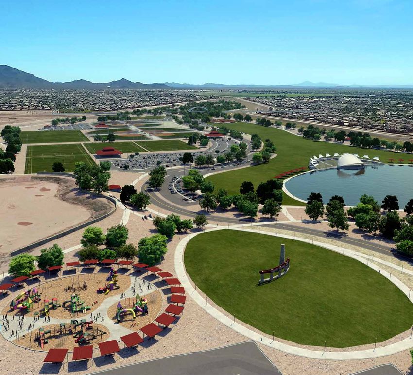
Table of
    Contents

4
Acknowledgments................................................................................2           4.0 Master Concept Alternatives......................................................42                  Appendix A – Workshop Summaries
Executive Summary..............................................................................6                 Master Concept Alternatives...................................................... 43               Appendix B – Business Plan
Introduction........................................................................................ 16          Concept 1................................................................................. 43
                                                                                                                                                                                                                    Appendix C – Infrastructure Report
                                                                                                                 Concept 2................................................................................. 43
1.0 Site Inventory and Analysis........................................................ 18                                                                                                                          Appendix D – Irrigation Analysis Report
                                                                                                                 Concept 3................................................................................. 43
       Design Diagram........................................................................ 21
                                                                                                                 Concept Vision One .................................................................. 44           Appendix E – Traffic Analysis
       Site Tour................................................................................... 21
                                                                                                                 Concept Vision Two................................................................... 46           Appendix F – Geotechnical Report
       Flood Control Expectations ........................................................ 23
                                                                                                                 Concept Vision Three ................................................................ 48
       Hydrology/Hydraulics ................................................................ 23                                                                                                                     Appendix G – Drainage Analysis
       Phase 1 Environmental Site Assessment.................................... 23                        5.0 Final Master Concept Plan.........................................................50
       Traffic....................................................................................... 24         Final Master Concept Plan......................................................... 51
       Utilities..................................................................................... 26         Facilities................................................................................... 52
       Water Source Options................................................................ 26                   Fields, Courts, and Amenities.................................................... 53
                                                                                                                 Programming Capacity.............................................................. 53
2.0 Community Outreach..................................................................28
                                                                                                                 Infrastructure Recommendations................................................ 58
       Process.................................................................................... 29
       Parks and Recreation Master Plan 2013/2014............................. 29                          6.0 Opinions of Probable Construction Cost....................................62
       Resident Telephone Survey 2014............................................... 29
                                                                                                           7.0 Phasing.......................................................................................64
       Sports Fields Needs Assessment............................................... 29
                                                                                                                 Site Plan Concept...................................................................... 65
       Community Focus Group Meetings............................................. 29
                                                                                                                 Phase 1.................................................................................... 66
       Website Comment Input Form.................................................... 35
                                                                                                                 Phase 2.................................................................................... 67
       Town Staff Department Input Workshops.................................... 35
                                                                                                                 Phase 3.................................................................................... 68
       Homeowner Association (HOA) Meetings.................................... 35
                                                                                                                 Private/Public Partnership Opportunities..................................... 69
       Town Planning Commission and Design Review Board................ 35
                                                                                                                 Final Master Concept Plan......................................................... 70
3.0 Programming..............................................................................36
                                                                                                           8.0 Schedule.....................................................................................72
       Surrounding Site Locations and Amenities.................................. 37
       Expressed Level of Need for Facilities in Regional Park............... 38                           9.0 Conclusion.................................................................................. 74
       Workshop 2 Plan Options........................................................... 40
                                                                                                                 Recommendations..................................................................... 75
                                                                                                                 Park Phasing Strategies............................................................. 75

                                                                                                                                                                                                                     Regional Park Master Concept Plan        5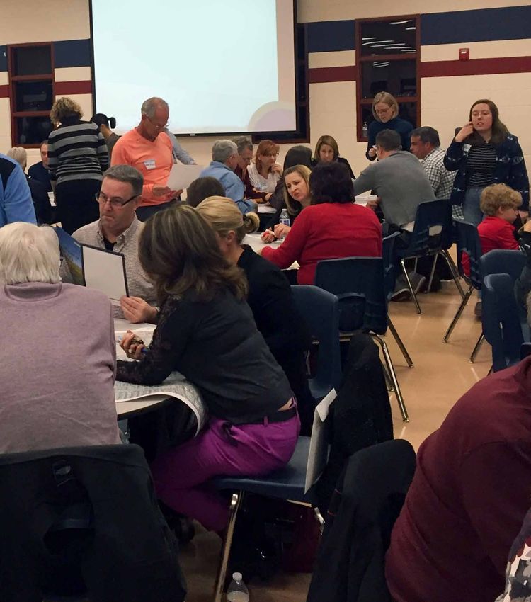
Executive
    Summary

6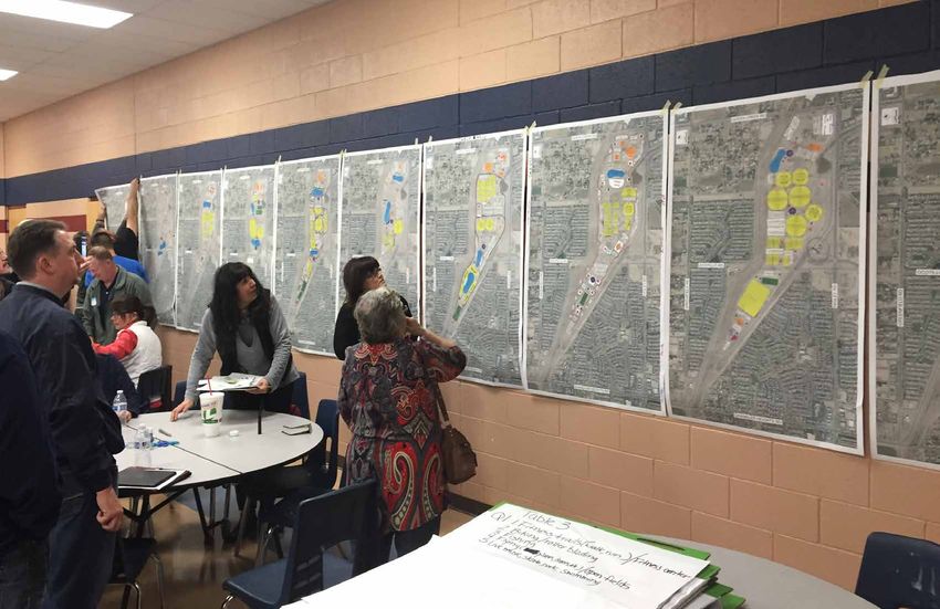
Ray Rd
Ellsworth Rd
CHANDLER HIGLEY
Chandler Blvd
LOOP
101
Introduction
Inventory
LOOP
202
ay
dw
loo
The Gilbert Regional Park is uniquely positioned to set a new standard for parks and
aF
and Analysis Germann Rd
op
recreation both in Arizona and nationally. This park offers the opportunity to dedicate
ri c
Rit
Ma
272 acres to provide both passive and active recreation amenities with open space to ten
st
Ea
The proposed site encompasses 272 acres ho
us
serve multiple community needs. Queen Creek Rd Que
en Creek Was h eR
of land located at the southwest corner of d
The 272 acres available for the Gilbert Regional Park are comprised of 47 acres owned by the Queen Creek Road and Higley Road within REGIONAL
Town of Gilbert (TOG or Town) in the northern part of the Chandler Heights Basin (CHB) Area and Sections 15 and 22 of Township 2 South, Ocotillo Rd PARK
Site Location
225 acres owned by the Flood Control District of Maricopa County (FCDMC). The Town entered into Range 6 East. The property is within the
87
Higley Rd
Power Rd
an agreement with Maricopa County for a recreation easement on the 225 acres. These discussions TOG and bounded by Higley Road to the
led to an Intergovernmental Agreement (IGA) between the Town and FCDMC in May 2015. east, Queen Creek Road to the north,
The Gilbert Regional Park Queen Creek Wash to the northeast, and the
Riggs Rd
Master Concept Plan is based East Maricopa Floodway (EMF) to the west.
SUN LAKES CHANDLER HEIGHTS
significantly on past inputs
and input from a broad-based The following goals were identified
community outreach program. by the project team for the Gilbert
It identifies park and recreational Regional Park Master Concept Plan: Site Tour
facility improvements and amenities
The project team conducted a
that are supported by the community ¬ The highest priority for the Gilbert Regional Park site tour of the 272-acre site in
and prior planning documents. Gilbert
Master Concept Plan is to engage and inspire December 2015 with key Town
Regional Park will be a premiere
community participation, solicit input, build staff and FCDMC personnel.
regional destination, but it is critical
consensus, and develop project support within the The site is divided into three
to create a plan that balances the
community’s recreational needs with Community. areas:
regional use. ¬ The project should utilize previously completed ¬ Lower Basin – 75 acres,
planning efforts including the recently completed FCDMC-owned
Town Parks and Recreation Master Plan (2014) and ¬ Upper Basin – 150 acres,
The Gilbert Regional Park Community Survey (2014) to guide programming. FDCMC-owned
Master Concept Plan ¬ High and Dry – 47 Acres,
was developed through ¬ The community involvement plan developed must Town-owned
a tailored community be specific and tailored to identify the recreation
engagement/stakeholder needs that will be supported by the Community
input process, identifying during the programming of the park.
what the site can ¬ The development of the Gilbert Regional Park
Flood Control Expectations
accommodate and ¬ The IGA provides the guidelines for the development ¬ The final concept plan must provide the current
Master Concept Plan should keep the primary
and maintenance of recreational amenities within the basin stormwater basin volume storage.
a sustainable function of the basin at the forefront, as the areas. Any future improvements to the basin areas will ¬ All proposed recreational amenities within the basin
implementation/ proposed recreation amenities should not reduce or need to maintain FCDMC access for large equipment to areas are subject to FCDMC approval and will require
operations plan. alter the flood control functions of the facility such provide maintenance and operations of the FCDMC facility. a right-of-way permit from the FCDMC prior to
as capturing, storing, and conveying stormwater. ¬ Flood control remains the primary purpose of the construction.
¬ The concept plan and estimate of probable basin and the Town’s uses may not materially reduce, ¬ The existing berm within the lower basin area must
diminish, or alter the flood control features of the basin maintain a minimum 4:1 (H:V) slope with a protective
construction costs are to be defined to a level
areas or the capturing, storing, and conveying flood and liner in the berm—any amenities will need to remain
that will provide sufficient information for the
stormwater. outside the limits of the protective liner.
subsequent design/development phases.
¬ The drainage requirements for the development of ¬ Restroom buildings are allowed, but must be outside the
recreational amenities within the basin areas will need basin water surface elevation.
to accommodate the first-flush storage, screening, and
treatment of a stormwater runoff from a storm event.
2 Regional Park Master Concept Plan E XECUTIVE SUMMARY 3
Regional Park Master Concept Plan 7
IGA with FCDMC
“Flood control remains the primary
Community Outreach
The Town entered into an IGA with the FCDMC in 2015. As
When developing mulit-faceted recreation programs and facilities in one large regional park, it is important to gain as much
the park amenities are developed, it will be imperative to purpose of the basin and the Town’s uses
keep the provisions of the IGA at the forefront. The goal of community engagement as possible. A multi-scale approach was utilized by the project team to gather productive and specific user
may not materially reduce, diminish, or
the IGA is to provide the Town access to and use of the basin information, programming data, design concepts, and sustainability ideas from the Gilbert community.
alter the flood control features of the basin
for recreational purposes. The IGA provides the Town with a The Gilbert Regional Park project included a thorough community engagement process that began in mid-2013 when the Town
no-cost, non-exclusive Recreational Use Easement over the or the capturing, storing, and conveying
started community meetings for the Parks and Recreation Master Plan. Input tools were utilized to assess the needs of the
Easement Area identified within Exhibit A of the IGA. The uses flood and stormwater.” —2015 IGA community for recreation facilities and programs, gather feedback, and review the conceptual program and plans. The following tools
identified include: construction, maintenance and operation were included in the project:
of parks, landscaping, fencing, signage, lighting, and other
¬ Priorities from the Parks, Recreation, and Trails Master ¬ Community Focus Group Meetings (January 2016)
compatible recreational uses and related appurtenant facilities Traffic Plan (2014)1 ¬ Public Community Input Workshops (January-March 2016)
or improvements for the use and enjoyment of the general Major streets adjacent to the development include Higley Road,
public. Construction of and improvements to recreational ¬ Resident Telephone Survey (2014)2 ¬ Planning & Parks Staff In-House Workshop Meetings
Queen Creek Road, Greenfield Road, and Chandler Heights
amenities will be at no cost to the FCDMC, and also require ¬ Sports Field Needs Assessment (2015)3 (March 2016)
Road. The site will be accessed locally via Queen Creek Road,
approval from the FCDMC prior to start of construction. The Higley Road, Greenfield Road, and Ocotillo Road. Regional ¬ Key Individual Interviews (January 2016) ¬ Town of Gilbert Website Comment Forms (January-April
requirement of the IGA is that first and foremost the basin must 2016)
access is expected to be provided by Loop 202 and other local
function as a flood control facility. arterial streets such as Germann Road, Riggs Road, Val Vista All the input tools helped to inform and formulate the vision for the Gilbert Regional Park. The lists of amenities and recreation
Drive, Chandler Heights Road, and Power Road. programs that are shown in this report are a direct result of the ideas and conversations from Town citizens ranging from individuals,
Utilities small groups, large groups, to randomly-selected individuals, invited user group representatives, elected and appointed officials,
The proposed site location is situated within and is surrounded by existing utility infrastructure within Queen Creek Road, Higley staff, consultants, and volunteers. 1. Town of Gilbert Parks, Recreation, And Trails Master Plan, Plan*et, February 13, 2014
Road, and the Ocotillo Road alignment. The following utility facilities/companies were notified and maps were collected for the 2. Town of Gilbert Community Survey, National Research Center, Inc., July 2014
3. Town of Gilbert Sports Fields Needs Assessment, RJM, May 2015
proposed project area.
¬ CenturyLink ¬ City of Mesa – reclaimed water
Workshop 1 Summary
¬ Cox Communications ¬ Roosevelt Water Conservation District
(RWCD) – irrigation The advertised workshops were attended by the general public. After the workshops were completed, the consultant team
¬ Southwest Gas
identified the top answers from all groups for each topic presented. They are listed below:
¬ Town of Gilbert – sanitary sewer, potable water, ¬ Salt River Project (SRP) – electrical, communications,
reclaimed water water, ground water, generation Question 1 Question 2
What are the most important recreation programs that you What are the most important facility amenities you think are
think are needed in the Regional Park? needed in the Regional Park?
Irrigation Water Source Options Top responses (in order of preference): Top responses (in order of preference):
The Town maintains an ordinance (66-356B) requiring any Another option discussed was to use an aquifer storage 1. Bike/Hike/Walk Programs (Trails) 1. Recreation Center
turf facilities greater than five acres to use reclaimed water recovery (ASR) well on the park site as a supplemental
2. Field Sports Programs 2. Sports Fields
for irrigation. The Town’s reclaimed water distribution water source during peak demands. The ASR Well can
system is continuously pressurized. System pressure is also be used to recharge during winter months. The 3. Outdoor Performing Arts Programs 3. Trails (Multi-Use)
typically between 30 and 60 pounds per square inch (psi). reclaimed water is of high quality and not anticipated to 4. Fishing and Boating (Lake Programs) 4. Picnic Ramadas
The installation of a reservoir and booster station are present any issues. 5. Fitness Programs 5. Aquatics/Pools
necessary for storage and higher pressure.
6. Picnicking 6. Amphitheater
7. Play (Playgrounds) 7. Lakes
8. Aquatics Programs 8. Playgrounds
9. Indoor Recreation Programs and Activities 9. Skate Park
10. Dog Training (Dog Park) 10. Dog Park
11. Sports Programs 11. Tennis
12. Skateboarding 12. Splash Pad
13. Archery
14. Gardening Programs
4 Regional Park Master Concept Plan E XECUTIVE SUMMARY 5
8
Regional Park Master Concept Plan
Question 3 Workshop 2 Plan Options
What are your thoughts regarding funding construction and ongoing operations of the Regional Park?
Top responses (in order of preference):
Workshop 2
A. Construction Funding B. Ongoing Operations/Maintenance These four park plan options presented at Workshop 20
17 Feedback
Number of Groups’ Favorite Plan
1. Bonds 1. User Fees 2 were designed to explore the best and most
15
2. Sponsorships 2. Special Events appropriate programming and site plan relationships,
3. Donations 3. Memberships given the public and stakeholder input and range of 10 9
4. Sales Tax 4. Concessions opportunities and constraints. These four concepts
5. Fundraising 5. Fundraising 5
were then ranked by Workshop 2 participants, Town
6. User Fees 6. Volunteers 0 1
staff, and other stakeholders. Programming and site 0
7. Naming Rights 7. Non-Resident Fees Plan Plan Plan Plan
plan relationships shown in the two most preferred Option 1 Option 2 Option 3 Option 4
8. Sell Land Preliminary Plan Option
plan options, as selected by the group, were utilized
9. Private/Public Partnerships
in the genesis of the three concept plan alternatives
presented in Workshop 3.
Plan Options Presented at Workshop 2
Workshop 2 Summary
The advertised workshops were attended by the
general public. After the workshops were completed,
the consultant team identified the top answers of all
groups for each of the topics presented. They are
listed below:
Question 1 Question 2
Please provide your ranking of the four plans (most favorite is 1, Please provide suggestions to improve any of the plans to make
least favorite is 4); and explain why. What modifications would them more sustainable and cost-effective.
you make to improve them? Please use the comment cards to
Top responses were as follows (in order of preference):
provide your response.
1. Solar panels to reduce power use and for lighting CONCEPT 1 CONCEPT 1 CONCEPT 3 CONCEPT 3
Modifications/Improvements (in order of priority): ballfields
1. Add disc golf 8. Benches
2. Food truck/vending area
2. Add parking on west 9. Walking bridge across
3. Flexible multi-purpose space for wedding rentals, special
side for access to lake
events, car shows, swap meets
ballfields 10. Need eight racquetball
4. Farmer’s markets and arts & crafts fairs area
3. Larger lake or another courts
5. Naming rights/sponsorships
lake in lower area, 11. Archery
nature area 6. Native plants/xeriscape
12. Game courts
4. More playgrounds near 7. “Movie in the park” night
(shuffleboard, bocce, 4
sports fields square) 8. Volunteers
5. Need a maintenance 13. More volleyball and 9. Eliminate aquatics CONCEPT 2 CONCEPT 2 CONCEPT 4 CONCEPT 4
facility/yard badminton 10. Eliminate BMX
6. More splash pads 14. Indoor soccer
7. Larger dog park/ The workshop concluded with reminders about the next public
sectioned meeting dates for the project and the project website that is
available for providing comments.
6 Regional Park Master Concept Plan E XECUTIVE SUMMARY 7
Regional Park Master Concept Plan 9
Workshop 3 Summary
     The presentation given to the general public attendees at Workshop 3 was also presented to the Town’s Park Operations and                Concept 3
     Maintenance staff as well as the Parks, Recreation, and Library Services Advisory Board. At all presentations, comment cards were        Pros: Multi-use plaza offers great options. This design has a visual “wow” factor. Many people prefer the layout and location of the
     provided and completed. After the workshops were completed, the consultant team compiled and synthesized the comments from all           lake in this concept. The large playground in this design was very well-liked.
     workshops. Below is the summary of responses for each of the concept plans.                                                              Cons: Keep the sports fields out of the lower basin because of noise, loss of nature area, light pollution, and potential flooding. Not
     Concept 1                                                                                                                                enough nature areas.
     Pros: “Main Street” style retail. Most opportunities for active recreation. Passive use areas in South and active use areas in           Key features that were commented upon:
     North are excellent use of land. Keeping sports fields together allows nice flow. Lots of green space with ball fields shielded from
                                                                                                                                                1. Not enough trails in the nature area and trails from the interior to the main circumference are needed. Concern about the
     residential.
                                                                                                                                                   multi-use trail crossing over the two main entrances. Trail should avoid the retail area.
     Cons: Too much parking in the nature area. Dog park is too large and not in the good location. Lacks plaza for large events.               2. Separating the sports fields adds to the cost.
     Key features that were commented upon:                                                                                                     3. Separation of large/small play areas was good, but there should be more playgrounds.
       1. Amphitheater overlooks the lake but is too separate from          6. Concern about driving through retail to reach the park.          4. Seating in the amphitheater should face east due to late
          the great lawn and looks into the back of buildings.              7. Too much parking in the South end. This should be the               afternoon sun. There were also concerns about noise
       2. Shoreline of lake is not accessible and there is not a green         nature area with trails.                                            to surrounding homes, and the possible need to build a
          area nearby. Some believe lake is too large and “boring.”         8. Picnic ramadas are well-spread throughout the park.                 sound barrier.
       3. Should be more than one multi-use trail. It should have              However, there should be one large ramada also.                  5. Amphitheater has no connection to great lawn.
          more spurs, go all the way around the lake, and connect to        9. Dual playgrounds and splash pads are good.                       6. Boardwalks for pedestrians over the lake were well-liked,
          the regional trail system.                                                                                                               but some felt they were unnecessary and that the lake
                                                                            10. Different sizes of playgrounds are good for varying age
       4. Parking is too far from the sports fields and main use                groups. There should be more playgrounds.                          overall was too large. Avoid possible interference with
          areas.                                                                                                                                   kayaks and pedal boats.
                                                                            11. Incorporate outdoor wedding pavilion next to lake.
       5. Not enough sports fields in this plan. Should add some on                                                                             7. Retail facing the park was good, but the interior parking
          west side north of Ocotillo Road.                                                                                                        area seemed too “strip mall” and some felt there was too much retail overall in this plan.
     Concept 2                                                                                                                                  8. Shaded event area for outdoor weddings was private and secluded.
     Pros: Clustering of fields together North of Ocotillo Road.
     Amount and location of natural space is very good. Number of                                                                                                                                     Additional Comments from staff on all three concepts:
     playgrounds is nice. Best placement of amphitheater in relation                                                                                                                                  1. Needs to be an area for outdoor exercise classes and “boot camps.”
     to great lawn and for least impact from noise. The location of                                                                                                                                   2. A large shaded playground with nearby cluster ramadas and splash pad
     retail in the upper corner is also liked by many.                                                                                                                                                   could be rented for parties.
     Cons: Not enough grassy areas. Too many sports fields! No
     space large enough for special events.                                                                                                                                                           Town Staff Department
     Key features that were commented upon:
                                                                                                                                                                                                      Input Workshops
       1. Concerns about traffic congestion and parking with fields
                                                                                                                                                                                                      In order to gain insight and input from Town staff regarding utilization of
          clustered so close together.
                                                                                                                                                                                                      the park, trends in parks and recreation programs and facilities, practical
       2. Plan has the preferred number of playgrounds (3), but it          7. Winding roads create more interesting flow.
                                                                                                                                                                                                      planning, and design input, a series of in-house input sessions were
          needs one large signature one.                                    8. Concern with conflict where multi-use trail crosses Ocotillo                                                                                                  facilitated with the Town Planning staff
       3. Relationship between the great lawn and amphitheater                 Road and other access roads. Also with safe access by                                                                                                         and Parks and Recreation Department
          is very good in this plan as is the relationship to the lake.        foot to retail areas.                                                                                                                                         staff. These sessions utilized a similar
          The noise impact would be reduced because sound is not            9. Trail should have more east/west paths and possibly loop                                                                                                      format to the public input workshops
          directed outside the park.                                           around each basin.                                                                                                                                            and included design charrettes that
       4. Great lawn should be bigger.                                      10. Nature area needs more ramadas. Also a large ramada                                                                                                          were utilized in the final conceptual plan
                                                                                near the lake for private special events would be good.                                                                                                      development.
       5. Retail location in the upper corner was desirable; however,
          there was concern that it was too congested.                      11. Design for the lake is preferred by many.
       6. Skate and bike parks under the bridge was great for
          shade.

       8                                                                                                                                                            Regional Park Master Concept Plan                                         E XECUTIVE SUMMARY                   9

10
                            Regional Park Master Concept Plan
Programming and Master Plan Alternatives
Park programming elements were generated based on the data collection, site analysis, agency requirements, stakeholder
input, and community outreach. The generation of these elements began with a series of design charrette sessions following
the early stages of the public involvement program. Charrette participants included key consulting team members, Town staff, Community Engagement Summary
and FCDMC staff. Design charrettes also took place during Workshop 1 meetings. Refining
The consultant team further Recreation Program Focus Group Website Stakeholder Creating the Vision
evaluated the existing Town the Vision Workshops Summary
Expressed Need Based on Previous Studies or Facility Meetings Comments Interviews Workshops (Design
Parks, Recreation, and Trails Charrettes)
Parks, Recreation, Telephone Sports Fields
Master Plan (2014), a telephone Survey Amphitheater High Medium Low High High High
survey (2014), the existing Recreation and Trails Master July 2014 Needs Assessment
Program or Facility Plan February 2014 (expressed March 2015 Aquatic/Recreation
Town of Gilbert Sports Fields (expressed need) (expressed need) High Medium High High Medium High
need) Center
Needs Assessment (2015),
results of the design charrettes, Amphitheater Low Low NA Baseball Medium Medium Low Low Medium Medium
and Workshop #1 feedback. Aquatic/Recreation Center High High NA Basketball/Gym Low Medium Low Medium Medium Medium
The team consolidated the Baseball Medium NA Low BMX Medium Low Low Low Low Low
results in to four distinct Basketball/Gym Medium NA NA Climbing Wall Low Medium Low Low Low Low
park plan options based on
BMX Low Medium NA Community Gardens Low Low Low Medium Low Low
expressed need.
Climbing Wall Low Low NA Cricket Low Low Low Low Low Low
Expressed Community Gardens Low Medium NA Disc Golf Medium Medium Low Low Medium Medium
Level of Need Cricket Low Low Medium Dog Park Medium High Low Medium Low Medium
for Facilities Disc Golf Low Low NA Equestrian Trail Medium Low Low Low Low Low
To develop the conceptual
Dog Park Low Low NA Fishing/Lake Low High Low High High High
design plans, all the results/
feedback from each of the public Equestrian Trail Low Low NA Football Low Low Low Low Low Low
input tools utilized for the project Fishing/Lake Medium High NA Ice Skating Low Low Low Low Low Low
were assembled in a matrix Football Low Low High Lacrosse Low Low Low Low Low Low
to compare relative ranking of Ice Skating Medium Low NA Multi-Use Center High High High High High High
expressed need. The following Lacrosse Low Low Medium Multi-Use Trails High High High High High High
tables provide a visual summary
Multi-Use Center Medium Low NA Nature Area Medium Low Low High Low Medium
of the level of need from each of
the input tools, with an assigned Multi-Use Trails High High NA Playgrounds High High Low High High High
relative value of either low, Nature Area Low Low NA Racquetball Low Medium Low Low Low Low
medium, or high. This provides Playgrounds High Low NA Ramadas High Medium Low High High High
valuable input for prioritization of Racquetball Low Low NA Rugby Medium Medium Low Medium Medium Medium
budget and phasing later in the
Ramadas Low Low NA Skate Park Low Low Low Medium Low Low
planning and design process.
Rugby Low Low Medium Soccer Low Low Low Low Medium Low
Skate Park Low Low NA Softball Low Medium Low Low Medium Medium
Soccer Medium Low High Special Events Low Medium Low Low Medium Medium
Softball Medium Low High
Splash Pad Medium High Low Medium High High
Special Events High Low NA
Sports Fields High High High High High High
Splash Pad Low Medium NA
Tennis Medium Medium Low Medium Low Medium
Sports Fields Medium High High
Track (Athletics) Low High Low Low Low Low
Tennis Medium Low NA
Visual/Performing Arts Low Medium Low Low Low Low
Track (Athletics) Low Low NA
Volleyball Low Medium Low Low Medium Low
Visual/Performing Arts Medium Low NA
Volleyball Low Low NA
10 Regional Park Master Concept Plan E XECUTIVE SUMMARY 11
Regional Park Master Concept Plan 11Master Plan Alternatives Master Plan Alternative Three
Three Master Plan alternatives were developed based on the findings.
POTENTIAL ACCESS
TO CHANDLER
HEIGHTS ROAD
Open Space/
Trailhead
Master Plan Alternative One Parking
80 Spaces
Parking
Disc Golf
100 Spaces Ropes Course
11 Acres
Parking
50 Spaces
Dog Park
Mountain Bike
Skills Park
POTENTIAL ACCESS
TO CHANDLER Parking
HEIGHTS ROAD 50 Spaces Bike Park
Parking
60 Spaces Drone Parking
Parking
Ziplining Obstacle Course 200 Spaces
380 Spaces
Open Space/
Trailhead Great Lawn
5 Acres
Mountain Bike
Trails Parking Shaded
150 Spaces Event Area
Playground
(FUTURE CONNECTION)
Ramada Lake Amphitheater Parking
Play 470 Spaces
8 Acres Capacity: 4k
OCOTILLO ROAD
Parking
(FUTURE CONNECTION)
220 Spaces Recreation (70k SF)/
Ramada Aquatic (40k SF)/
Mountain Bike Skate Park Events (70k SF)
Bike Park
Skills Park and Trails
Multi-Use
Playground Plaza
Drone Obstacle
OCOTILLO ROAD
Course Parking
Parking Parking Parking
100 Spaces
200 Spaces 60 Spaces 315 Spaces
Ropes
Course Great Lawn
Parking 8 Acres Parking
Skate Park
70 Spaces 550 Spaces
Parking Parking
180 Spaces 400 Spaces
Dog Park Playground
Maintenance
Yard Splash
Disc Golf/ Maintenance
Zipline Area Yard Pads
QUEEN CREEK ROAD
Disc Golf
Ramada
16 Acres Retail
Retail
Playground 13k SF 32k SF
Great Lawn
24 Acres HIGLEY ROAD
Parking Food Truck Court
330 Spaces 50+ Spaces
Amphitheater
Capacity: 3k
Lake
Parking 8 Acres Retail
370 Spaces 17k SF Parking
350 Spaces
Event Center
70k SF
Parking Parking
675 Spaces 350 Spaces
Parking
270 Spaces
Berm with
Monument Sign
Parking
330 Spaces Recreation (50k SF)/
Aquatics (50k SF)
Center
Playground Parking
Maintenance
QUEEN CREEK ROAD
Yard 475 Spaces
Splash
Maintenance Pad
Yard
Parking
325 Spaces
Retail
13k SF
HIGLEY ROAD
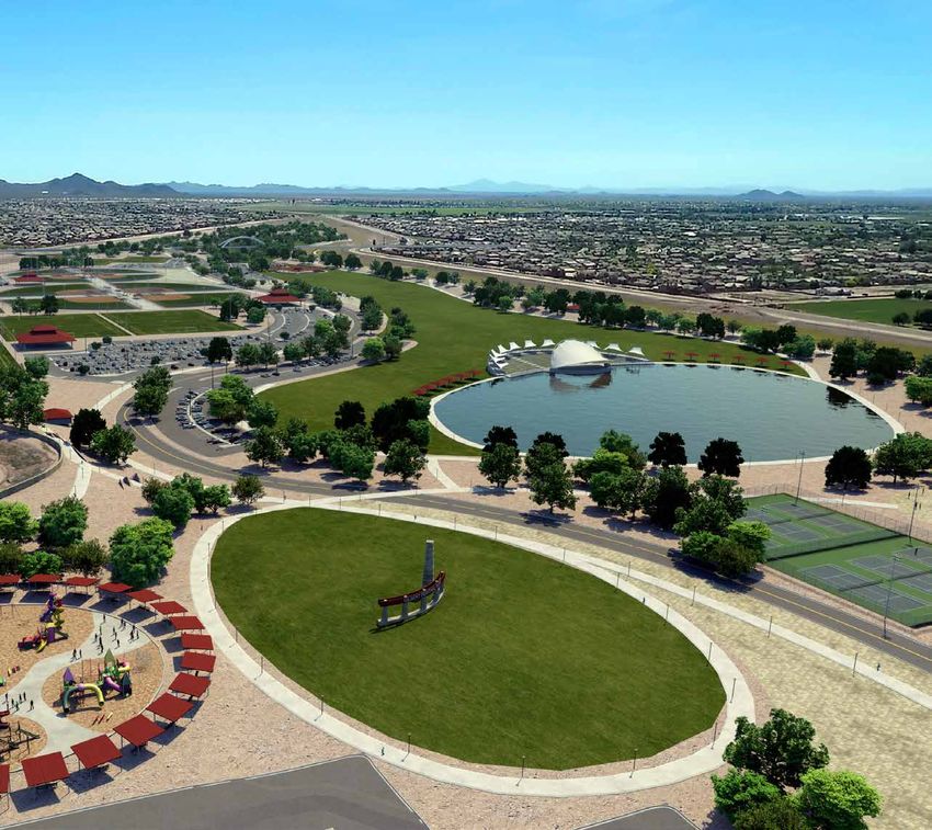
The final master plan has truly been shaped by the needs and vision of
the community. Master Plan Alternative One was selected as the final
concept. Additional refinements and modifications were made based on
comments received from workshop attendees, Town staff, and the Parks,
Recreation and Library Services Advisory Board.
Master Plan Alternative Two Final Master Plan
Open Space
Open Space
(FUTURE CONNECTION)
Mountain Bike Trails/
Open Space Disc Golf
OCOTILLO ROAD
Disc Golf
8 Acres
Trailhead
Ropes Course
Parking
220 Spaces
Dog Park
QUEEN CREEK ROAD
Play Parking
Ramada
80 Spaces Maintenance
Yard
Parking
Play Parking 80 Spaces
Ramada 180 Spaces
Parking
68 Spaces
Skate Park Maintenance
Yard
Bike Park Play
Parking
150 Spaces
Parking Large
225 Spaces Playground
Splash
Parking Parking Boardwalk/ Pad
Parking 120 Spaces 320 Spaces Pier Parking
150 Spaces Play 450 Spaces
Lake
Parking 8 Acres
Maintenance Recreation (60k SF)/
Yard 220 Spaces
Amphitheater Aquatics Center (50k SF)
Parking Great Lawn
Capacity: 3.5k
Flex Space/Parking 95 Spaces 7 Acres
500 Spaces
Events
Parking Center
65 Spaces (100k SF)
Cricket
Lake Retail
6k SF
Parking
900 Spaces
Parking
160 Spaces
Retail
9k SF
HIGLEY ROAD
12 Regional Park Master Concept Plan E XECUTIVE SUMMARY 13
12
Regional Park Master Concept PlanFields, Courts, and Amenities Traffic All currently signalized intersections are expected to operate at
The fields, courts, and amenities provided in the final Gilbert The FCDMC has been in contact with dirt brokers to identify acceptable levels of service (LOS), with overall intersection LOS
Trip Generation
Regional Park Master Concept Plan respond to the needs potential projects in need of earthwork. of D or better, for all analyzed buildout scenarios except for the
The regional park is expected to generate approximately 8,000
expressed during the community engagement process. These Chandler Heights Road/Higley Road intersection.
The following graphic depicts the cut and fill areas for the daily trips on a typical day, with up to approximately 12,000
amenities are organized to maximize their use and revenue proposed park site based on the Concept 1 grading plan. daily trips during a peak special event day such as when there Parking
potential, while ensuring the best and most appropriate The red-tone signifies areas for cut and the blue area signifies are multiple concurrent tournaments/events. The Regional Park The regional park is expected to generate parking demand
utilization based on site plan relationships. The proposed sports areas for fill. Darker color tones represent an increase in cut is expected to generate approximately 1,000 trips during the for approximately 2,500 spaces on a typical day, with up to
fields provide 46% of the fields recommended in the Sports or fill. busiest hour on a typical day, with up to approximately 2,000 approximately 3,700 spaces during a peak special event day
Fields Needs Assessment conducted in 2015. trips during the busiest hour on a peak special event day. such as when there are multiple concurrent tournaments/
events.
List of Amenities (in alphabetical order) Earthwork Exhibit Recommended Offsite Traffic Improvements
¬ Amphitheater ¬ Lake The Higley Road/Bridges Boulevard intersection is expected to The proposed parking supply is 4,075 spaces. Accounting for
need to be signalized before 2030 due to growth in background the projected parking demand, the park is expected to have
¬ Aquatics/Recreation ¬ Mountain Bike Skills
traffic regardless of whether the park is constructed or not. The 40% excess supply of parking spaces on a typical day and 10%
Center* Park
following offsite traffic improvements have been identified if the excess supply of parking spaces on a peak special event day.
¬ Berm with Monument ¬ Multi-Use Center*
park is constructed: Industry standard is that 15% excess supply (also termed 85%
Sign ¬ Pickleball utilization) represents an effectively “full” condition as drivers
¬ Disc Golf ¬ Queen Creek Road Improvements
¬ Playground and have to drive around sometimes to find open parking spaces,
¬ Dog Park Splash Pad ¬ Higley Road Improvements
resulting in inefficiencies in filling spaces.
¬ Drone Obstacle ¬ Retail* ¬ Future Ocotillo Road Bridge Improvements
Course ¬ Ropes Course*
¬ Food Truck Court ¬ Skate and BMX Park Potable Water
Opinions of Probable Construction Costs
¬ Great Lawn ¬ Tennis Courts Opinions of Probable Construction Costs (OPC) were derived information provided in the following table can be used to
Since the majority of the building facilities are located within
the Town-owned 47 acres, the recommendation for potable through a detailed process of quantity calculations for all park understand the order of magnitude investment required to
Infrastructure Recommendations elements represented in the Final Concept Plan and utilization design, construct, operate and maintain the park improvements.
water source is to utilize the existing 16-inch water line within
Irrigation Queen Creek Road. It currently has two existing eight-inch of current market unit pricing. Collectively, the financial
The recommended irrigation alternative is to utilize the Town’s water stub-outs to create an onsite eight-inch water looped Final Opinion of Probable Cost Subtotals
existing 18-inch reclaimed water main within the Ocotillo Road line for potable and create a secondary looped line for fire line. Category Full Build Out Phase 1 Phase 2 Phase 3
alignment to provide the park with reclaimed water as the The additional potable water needs for the remaining FCDMC Facility Totals $10,650,000 $575,000 $2,025,000 $8,050,000
irrigation water source. The park site shall utilize an onsite portion of park improvements shall utilize an internal looped Fields, Courts, and Amenities Totals $23,105,100 $2,592,750 $5,166,800 $15,345,550
lake to provide the required irrigation source storage. Irrigation water line with smaller diameter pipe from the larger looped Earthwork Totals* $3,940,507 $1,929,942 $899,855 $1,110,710
water for the turf fields, turf areas, and planting areas will line from the 47 acres to provide water service for the restroom Infrastructure Totals $28,838,715 $4,768,595 $12,309,095 $11,761,025
drawdown the reclaimed water from the lake to provide the Total Construction Cost $83,167,903 $12,332,859 $25,500,938 $45,334,106
buildings and water fountains.
required irrigation. Total Soft Cost $17,298,924 $2,565,235 $5,304,195 $9,429,494
Wastewater Operation Costs
Earthwork The recommendation for sanitary sewer source is to utilize
Total Construction + Soft Cost $100,466,827 $14,898,094 $30,805,133 $54,763,600
The lower basin area has been excavated to the proposed basin Net Operational Subsidy ($1,160,890) ($302,906) ($278,824) ($579,160)
the existing 30-inch water line within Queen Creek Road. The
depth and provides the ultimate storage volume. The upper basin Cost Recovery 45% 32% 23% 55%
depth of this existing 30-inch sanitary sewer line is 17 feet
has not been fully excavated to the proposed basin depth and deep along the park frontage area and allows for gravity flow Operation Financial Summary**
requires the removal of approximately 2.5 million cubic yards (CY) from the Town-owned 47 acres. The additional sanitary sewer Phase Revenue Expenditures Subsidy Cost Recovery
of dirt to provide the ultimate storage volume as required by the needs for the remaining FCDMC portion of park improvements Phase 1 - Park Operations $142,625 $445,531 ($302,906) 32%
FCDMC. The Town-owned high and dry 47 acres is outside of the shall utilize the existing 33-inch sanitary sewer line within
Phase 2 - Park Operations $84,900 $363,724 ($278,824) 23%
basin limits and does not require any drainage related excavation. Phase 3 - Park Operations $711,940 $1,291,100 ($579,160) 55%
the Ocotillo Road alignment. This 33-inch line is 18 feet deep
Total $939,465 $2,100,355 ($1,160,890) 45%
The project team met with the FCDMC to discuss options for and will also allow for gravity flow. The proposed restroom Aquatic $50,000 --- --- N/A
Private/Public
Opportunities
the removal of the 2.5 million CY of dirt from the upper basin buildings in the lower and upper basin areas shall connect into
Partnership
Recreation Center $50,000 --- --- N/A
due to downstream levee requirements from the Federal one sanitary sewer eight-inch mainline to provide one tie-in Multi-use Center $50,000 --- --- N/A
Emergency Management Agency (FEMA). The dirt removal is a connection to the existing 33-inch sanitary sewer main line. Ropes Course $50,000 --- --- N/A
function of flood control requirements and is the responsibility Retail $50,000 --- --- N/A
of the FCDMC at this time, however FCDMC does not have * Earthwork total to remove onsite dirt in the approximate amount of $27M is not included in the cost estimate. It is assumed that the FCDMC will remove the dirt.
** See Appendix A (Workshop Summaries) for complete Opinion of Probable Cost. See Appendix G (Business Plan) for derivation of Operation Financial Summary.
a concrete plan to remove the excess dirt by any timeframe. Note: Projected costs are representative of 2016 unit pricing and are intended to be used as an order of magnitude only. As more definitive timeframes are identified for implementation,
*Potential private/public partnership opportunities. appropriate cost adjustments based on current market conditions should be made. Actual costs may vary as they are affected by means, methods, and other economic forces.
14 Regional Park Master Concept Plan E XECUTIVE SUMMARY 15
Regional Park Master Concept Plan 13FINAL CONCEPT
Phasing Category Unit Qty
The Gilbert Regional Park can be constructed in multiple phases. Phase 3 Aquatic/Recreation Center* SF 100,000
Phase 3 is reliant on dirt removal and a potential 2020 Bond. Multi-use Center* SF 120,000
This phase includes the remaining upper basin amenities:
Maintenance Building/Yard EA 3
Facilities
¬ Multi-Use Recreation Fields with Lights (5)
Amphitheater SF 15,000
¬ Soccer Fields with Lights (4)
Retail* SF 30,000
¬ Baseball Fields with Lights (4)
Restroom Building EA 7
¬ Softball Fields with Lights (4)
Parking (Total Parking Spaces) EA 4,075
¬ Amphitheater
Baseball Field (Lighted) EA 4
¬ Playground with Shade
¬ Group Ramada (1) Basketball Court (Lighted) EA 4
¬ Ramadas (med. 4), (sm. 20) Disc Golf Hole EA 18
¬ Multi-Use Path (3 miles) Dog Park - Off leash area AC 3
¬ Trails (2 miles) Mountain Bike Skills Park EA 1
¬ Food Truck Plaza Multi-Purpose Field (Lighted) EA 5
¬ Great Lawn (24 acres) Pickleball Court EA 8
Ocotillo Bridge* ¬ Restroom Buildings (4) Playground (Iconic) EA 1
¬ Maintenance Yard (2) Playground (Shaded) EA 2
Fields, Courts, and Amenities
*Note: Ocotillo Road Bridge improvements are for reference only and not included with the cost of the park
project. Future Ocotillo Bridge design is recommended to begin with the Phase 3 design phase. Ramada (Small) EA 49
Private/Public Partnership
Ramada (Medium) EA 4
Opportunities
The Private/Public Partnership Opportunities phase can Ramada (Large Group) EA 1
Phase 1 be planned when the timing is optimistic and includes the Ropes Course* EA 1
Phase 1 is proposed to begin construction as early as July 2018. This phase includes the following amenities: 120,000-square-foot multi-use center and the 100,000 SF Signage (Monument-Park Name) EA 3
¬ Entry Monument ¬ Sand Volleyball Courts (6) ¬ 300 Parking Spaces aquatic/recreation center in the northern 47 acres.
Skate Park EA 1
¬ Lake (eight acres) ¬ Turf Area (2 acres) ¬ Queen Creek Road Deceleration
Thirty-thousand square feet of retail area is included in the total BMX Park EA 1
¬ Trail Around Lake ¬ Restroom Building Right-Turn Lane
build out. The northwest corner of Higley Road/Ocotillo Road is
¬ Iconic Playground ¬ Queen Creek Road Offsite ¬ Queen Creek Road Left-Turn Lane/ Splash Pad EA 1
zoned for commercial and could also provide retail opportunities
Improvements Median Improvements and connections to the park site. Soccer Field (Lighted) EA 4
¬ Splash Pad
¬ ASR Well ¬ Ingress/egress at both Queen Creek Softball Field (Lighted) EA 4
¬ Pickleball Courts (8)
Road and Higley Road
¬ Tennis Courts (6) ¬ Water/Sewer Infrastructure Tennis Court (Lighted) EA 6
Multi-Use Path (Paved) Miles 7.1
Phase 2 Trail (Unpaved) Miles 4.0
This phase encompasses the park area south of the future Ocotillo Road Bridge and includes the following amenities:
Great Lawn AC 24.0
¬ Disc Golf Course (18 holes) ¬ Multi-Use Path ¬ Restroom Buildings (2)
Volleyball Court (Sand) Lighted EA 6
¬ Skate Park ¬ Trails ¬ Maintenance Yard
¬ Bike Park ¬ Basketball Courts (4) *Potential private/public partnership opportunities
¬ Mountain Bike Skills Park ¬ Restroom Buildings (2)
¬ Ropes Course** ¬ Maintenance Yard
¬ Dog Park (3 acres) ¬ Basketball Courts (4)
**Potential private/public partnership opportunities.
16 Regional Park Master Concept Plan E XECUTIVE SUMMARY 17
14
Regional Park Master Concept PlanPotential Schedule Conclusion
As part of the project phasing recommendations, the consultant If the Town moves forward with the sale of the 138 acres of The Gilbert Regional Park represents an exceptional opportunity Emphasize Community Outreach
team also evaluated a potential schedule for the project and Town owned park property within the first quarter of 2017, to expand the Town’s parks and recreation system through a As the master/concept plan transitions from vision to future
phasing implementation. The schedule includes an overall the Phase 2 design could begin July 2017 and finish July strategic partnership with the FCDMC. Combining Town and study and design, it is recommended that the community
big picture timeline to understand the correlation of project County land ownership to achieve a 272-acre regional multi- continue to actively participate in the process.
2018 with the Phase 1 timeline. Construction for Phase 2
phasing, funding sources, and site constraints. use site will provide the area needed to help the Town meet
could start July 2018 and finish in July 2019. Balance Recreational Opportunities
current and future parks and recreation needs with particular
PHASE 1 Phase 1 could utilize System Development Fees PHASE 3 The sports fields and great lawn identified in Phase emphasis on diversity and sports fields. The purpose of this The park should provide a balance between sports fields,
(SDF) to construct recreational park amenities up to 30 acres. 3 could be an option for the 2020 parks bond. Phase 3 is amenities, and open space.
Gilbert Regional Park Master Concept Plan is to provide the
Phase 1 design could start July 2017 and finish in July 2018 situated in the upper basin area which requires 2.5 million CY vision and programming that will position the park to offer
(one-year duration). The Phase 1 construction could start July Infrastructure Improvements
of dirt removal to complete the FCDMC drainage basin ultimate opportunities for all Gilbert residents and become a year-round
2018 and finish in July 2019 (one-year duration). regional attraction for special events. Transportation and utility infrastructure improvements are
design. The haul off of the existing dirt from the CHB could
vital to the development of this regional park provide regional
PHASE 2 The Town of Gilbert voters approved a ballot require up to three years to excavate and haul dirt from the site. The master concept plan vision, goals, and objectives were connectivity and capacities needed for the facilities. The
measure in August of 2016 which authorizes the Town to The dirt removal is a function of flood control requirements and developed through a process that placed special emphasis on extension of Ocotillo Road across the park site and connections
sell approximately 138 acres of undeveloped, Town owned is the responsibility of the FCDMC at this time, however FCDMC past efforts, public outreach through the use of the Town’s with the park are critical to the parks accessibility and function.
park property. The property includes approximately 80 acres does not have a concrete plan to remove the excess dirt by any website, public meetings, focus group workshops, and Town
at the southwest corner of Greenfield Road and Chandler timeframe. The cost of the dirt removal would be an expense to leadership interviews. The plan is strategic in organization and Multimodal Regional Connectivity
Heights Road. The Town also owns approximately 58 acres the Town if the Town were to choose to accelerate Phase 3 of provides flexibility for future decision making. Provide multimodal circulation opportunities that include
at the southwest corner of Greenfield Road and German Road. the Concept Plan. The intention of the following key recommendations is to trail and pathway connections with the regional system and
The Town is authorized to sell the property as of August 2016 provide a master concept plan that identifies implementation throughout the park.
The Phase 3 design could begin July 2021 and finish July
and could begin the process as early as February 2017. strategies for the park and its many assets that reinforce Alternative Water Sources
2022 (one-year duration). Construction for Phase 3 could
connectivity within the park and its surrounding areas.
The Ocotillo Road Bridge has also been identified within the start July 2022 and finish in July 2023 (one-year duration). Use reclaimed water as the source for irrigation needs by
Collectively, the strategies are intended to create a special and
current Town CIP for year 2020. The Ocotillo Road/Bridge The recommendation is to begin design of Ocotillo Bridge means of onsite storage via a lake system and use of an ASR
highly unique regional park that has a distinctive identity and
improvements project completed an initial study in 2000, but during Phase 3 design. The Town will also need to look at well to allow for the use of reclaimed water throughout the year
will provide for memorable experiences.
final planning, design, and construction timeframes have not the constructability of the bridge in terms of timing of park when the peak summer months are deficient.
The key recommendations of this plan are as follows:
been identified at this point. The park master concept plan construction and final synergy of the site to enhance crossing Private/Public Partnership Opportunities
assumes a bridge spanning the basin/park area with access and programming coordination of park improvements. Recommendations The recommended approach for the development of the multi-
from Ocotillo Road to the south and north park area. The Progressive Management Techniques use center, recreation and aquatics center, retail, and ropes
PRIVATE/PUBLIC PARTNERSHIP OPPORTUNITIES Private/
timing of the new regional park could re-prioritize the need This unique regional park with its scale and mix of facilities and course is to consider utilizing private/public partnerships if
public partnership opportunities can occur at any time
for the Ocotillo Road Bridge improvements as the access the dynamic partnership created between the Town and FCDMC appropriate. If no private/public partnership is available, the
throughout the duration of the project. These opportunities
for Phase 2 could be provided from Ocotillo Road in lieu of will require best practices of the managing land owners to Town should conduct a feasibility study with business plan prior
include a multi-use center, a recreation/aquatics center, retail,
the interior park roadway from Phase 1 through Phase 3. maintain a collaborative approach that ensures the flood control to design of these facilities in order to define the programming,
and a ropes course.
The Phase 3 improvements might be enhanced by Ocotillo functions and recreational uses co-exist for the long term. Town policy goals, cost recovery, and revenue generation.
Road/Bridge improvements for access as well as design and Continued community outreach should remain a guiding force
construction coordination between the park and roadway / during the feasibility study and final design throughout the
bridge improvements. duration of the project.
PRIVATE/PUBLIC PARTNERSHIP OPPORTUNITIES Each recommendation or area of focus and phase of
Aug. 2016 implementation is important, but more than that, the strategic
Vote for TOG Nov. 2020 Jul. 2021 - Jul. 2022 Jul. 2022 - Jul. 2023
$ Bond PHASE 3 PHASE 3 approach of their interconnection is what will help position the
140 AC Land Sale Jul. 2017 - Jul. 2018 Jul. 2018 - Jul. 2019 2020 Design Construction Gilbert Regional Park for long-term success and sustainability,
PHASE 1 PHASE 1 Nov. 2024
Ocotillo Bridge $ Bond 2024 and ultimately create a highly distinctive and memorable
30 AC SDF - Design 30 AC SDF - Const. July 2021
regional park that enhances the Town’s quality of life and
2016
2017
2018
2019
2020
2021
2022
2023
2024
2025
2026
position in the Metropolitan area.
Feb. 2017 July 2023 Business Planning For Major Facilities
Land Sale Jul. 2017 - Jul. 2018 Jul. 2018 - Jul. 2019 Phases 1 –3 Conduct detailed feasibility studies and business planning for
(if approved) PHASE 2 PHASE 2 Complete the recreation/aquatic center and multi-use center facilities.
Feasibility Study Construction
& Design
18 2016 - 2021 Regional Park Master Concept Plan E XECUTIVE SUMMARY 19
Regional Park Master Concept Plan
Excavation and Haul-Off of Borrow Dirt From Site by FCDMC
15Introduction 16
The Gilbert Regional Park is uniquely positioned to set a new standard for parks and recreation both in Arizona and nationally. This park offers the opportunity The following goals were identified by the project team for the
to dedicate 272 acres to provide both passive and active recreation amenities with open space to serve multiple community needs.
Gilbert Regional Park Master Concept Plan:
The 272 acres available for the Gilbert Regional Park are comprised of 47 acres owned by the Town of Gilbert (TOG or Town) in the northern part of the
Chandler Heights Basin (CHB) Area and 225 acres owned by the Flood Control District of Maricopa County (FCDMC). The Town entered into an agreement with ¬¬The highest priority for the Gilbert Regional Park Master
Maricopa County for a recreation easement on the 225 acres. These discussions led to an Intergovernmental Agreement (IGA) between the Town and FCDMC
in May 2015. Concept Plan is to engage and inspire community
participation, solicit input, build consensus, and develop
The Gilbert Regional Park Master Concept Plan is based significantly on past inputs and input from a broad-based community outreach program. It identifies
park and recreational facility improvements and amenities that are supported by the community and prior planning documents. Gilbert Regional Park will be a project support within the Community.
premiere regional destination, but it is critical to create a plan that balances the community’s recreational needs with regional use.
¬¬The project should utilize previously completed planning
efforts including the recently completed Town Parks and
Recreation Master Plan (2014) and Community Survey (2014)
to guide programming.
The Gilbert Regional Park Master Concept Plan
¬¬The community involvement plan developed must be specific
was developed through a tailored community
and tailored to identify the recreation needs that will be
engagement/stakeholder input process, identifying supported by the Community during the programming of
what the site can accommodate and a sustainable the park.
implementation/operations plan. ¬¬The development of the Gilbert Regional Park Master Concept
Plan should keep the primary function of the basin at the
forefront, as the proposed recreation amenities should not
reduce or alter the flood control functions of the facility such
as capturing, storing, and conveying stormwater.
¬¬The concept plan and estimate of probable construction
costs are to be defined to a level that will provide sufficient
information for the subsequent design/development phases.
Another prevailing challenge facing the Gilbert Regional Park lies in the complexities of
providing multiple amenities and attractions for a diverse user group while keeping the basin’s
primary function at the forefront. The development of the master concept plan takes these
challenges into consideration and emphasizes the park’s existing features and surroundings
while also providing the community and region with a variety of recreational experiences
tailored to this unique outdoor destination.
The Town has been fully transparent and is dedicated to ensure the master concept plan is
truly shaped by the needs of the community. Gilbert Regional Park will be a distinguished
asset to the Town and the region. At the heart of this project is the need to engage and
capture community support in order to make the park a reality. The master plan community
outreach program, as well as previous public outreach with the Sports Fields Needs
Assessment and the Parks, Recreation, and Trails Master Plan inspire ownership and establish
support for the project.
Regional Park Master Concept Plan 17You can also read