Inventory & Assessment - Appendix A: Previous and Ongoing Plans and Studies JUNE 2020
←
→
Page content transcription
If your browser does not render page correctly, please read the page content below
Inventory & Assessment                               Prepared by:
Appendix A: Previous and Ongoing Plans and Studies
JUNE 2020
Acknowledgments
PREPARED FOR AEROTROPOLIS ATLANTA COMMUNITY IMPROVEMENT DISTRICTS
IN ASSOCIATION WITH LOCAL PARTNERS:
AEROTROPOLIS ATLANTA ALLIANCE
ATLANTA REGIONAL COMMISSION
CITY OF COLLEGE PARK
CITY OF EAST POINT
CITY OF FOREST PARK
CITY OF HAPEVILLE
CITY OF SOUTH FULTON
CLAYTON COUNTY
FULTON COUNTY
GEORGIA DEPARTMENT OF TRANSPORTATION
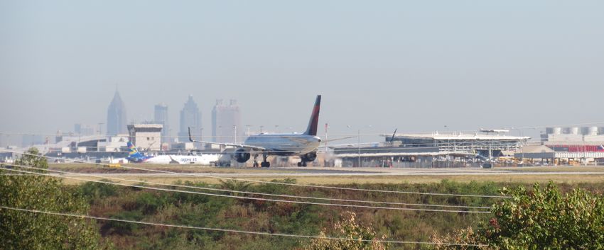
HARTSFIELD-JACKSON ATLANTA INTERNATIONAL AIRPORT
PREPARED BY:
IN PARTNERSHIP WITH:
ALL IMAGES COURTESY OF GRESHAM SMITH UNLESS OTHERWISE SPECIFIED
Table of Contents                                                                                                                                                                                                                                         List of Figures
PREVIOUS AND ONGOING PLANS AND STUDIES..........4                                                                                SR 6 Access Management Plan (2015)............................................................20                         FIGURE 1: Aerotropolis Atlanta Core......................................................................... 5
                                                                                                                                 South Fulton CID Multimodal Study (2018)....................................................20                           FIGURE 2: AeroATL Greenway Plan Priority Trail Network................................ 6
APPENDIX OVERVIEW...................................................................................................... 5
                                                                                                                                 South Fulton CTP (2013)........................................................................................20        FIGURE 3: AeroATL Greenway Model Mile Feasibility Study Segments........ 7
PREVIOUSLY COMPLETED PLANS ............................................................................. 5                                                                                                                                                FIGURE 4: AACIDs Transit Study Recommendations............................................ 8
                                                                                                                                 South Fulton Parkway Corridor Plan (2016)..................................................21
     AACIDs Blueprint (2016) ........................................................................................ 5                                                                                                                                   FIGURE 5: Threefold Framework of The Atlanta Region’s Plan........................ 9
                                                                                                                                 SR 74 Comprehensive Corridor Study (2018)...............................................22
     AeroATL Greenway Plan (2018)............................................................................ 5                                                                                                                                           FIGURE 6: ASTRoMAP System.....................................................................................11
                                                                                                                                 Union City Comprehensive Plan (2015)..........................................................22
     AACIDs Master Plan (2017).................................................................................... 7                                                                                                                                      FIGURE 7: Boulevard CID Master Plan Study Area..............................................11
                                                                                                                            ONGOING PLANS & STUDIES.....................................................................................23
     AACIDs Transit Feasibility Study (2019)............................................................. 7                                                                                                                                               FIGURE 8: City of Atlanta Freight Route Network...............................................12
                                                                                                                                 Clayton County MARTA Expansion.....................................................................23
     ARC Freight Mobility Plan (2016)......................................................................... 9                                                                                                                                          FIGURE 9: East Point TOD Focus Areas...................................................................14
                                                                                                                                 Mountain View Master Plan..................................................................................23
     The Atlanta Region’s Plan – Transportation (2018)...................................... 9                                                                                                                                                            FIGURE 10: Future Development Nodes in Clayton County...........................16
                                                                                                                                 N. Central Avenue Pedestrian & Transit Improvement Study ................23
     ARC TIP FY2018-2023 (2018)..............................................................................10                                                                                                                                           FIGURE 11: College Park LCI Study Area................................................................17
                                                                                                                                 Old Dixie/Tara Blvd Master Plan.........................................................................23               FIGURE 12: Map of Hartsfield-Jackson Atlanta International Airport.........19
     ARC Truck Parking Study (2018).........................................................................10
                                                                                                                                 South Fulton CTP Update......................................................................................23          FIGURE 13: South Fulton Parkway Areas of Opportunity................................21
     Atlanta Strategic Truck Route Master Plan (2010)......................................10
                                                                                                                                 Virginia Avenue SMART Corridor Study............................................................23
     Boulevard CID Master Plan (2013)....................................................................11
     Cargo Atlanta Freight Study (2015)..................................................................11                 CAPITAL & MAINTENANCE PROJECTS.....................................................................24
     Cargo Atlanta Health Impact Assessment (2016).......................................12                                      Programmed Projects ............................................................................................24
     City of Atlanta Transportation Plan (2018)....................................................12                            Long-Term Projects..................................................................................................26
     City of College Park Comprehensive Plan (2016).......................................13                                REFERENCES.................................................................... 27
     City of East Point Comprehensive Plan (2017)............................................13
     City of East Point Main Street TOD (2012).....................................................14
     City of Forest Park Comprehensive Plan (2018)..........................................15
     City of Hapeville Comprehensive Plan/LCI Study Update (2017).........15
     City of Riverdale Comprehensive Plan (2018)..............................................16
     Clayton County Comprehensive Plan (2014)................................................16
     Clayton County CTP Update (2018)..................................................................17
     College Park LCI Update (2017).........................................................................17
     Fulton County 2035 Comprehensive Plan (2016).......................................18
     Fulton County Transit Master Plan (2018)......................................................18
     Georgia State Rail Plan (2015)............................................................................18
     Georgia Statewide Freight & Logistics Plan (2017).....................................18
     Hartsfield-Jackson Airport Master Plan (2015)............................................19
Previous
 4       and Ongoing Plans and Studies
Appendix Overview                                                               The Blueprint provides an overview of existing conditions in the Aerotrop-
                                                                                olis area and identifies areas of opportunity while discussing Federal Avi-
                                                                                ation Administration (FAA) height restrictions for developments near the
                                                                                airport. Existing conditions pertaining to housing, transportation, historical
As part of the Inventory and Assessment task for the Aerotropolis Freight       and natural resources, economic clusters, and real estate are discussed in
Cluster Plan, the project team reviewed relevant completed and ongo-            this document. Industrial real estate activity was noted for experiencing a
ing plans and studies. The intent is to identify and summarize recom-           vacancy rate at a 14-year low; however, the south Atlanta area was expe-
mendations, strategies, and policies that may have implications for freight     riencing an average vacancy rate at 9.4 percent at the time of the plan’s
operations in the Aerotropolis Atlanta Community Improvement Districts          publication.
(AACIDs) Freight Cluster study area. The impact of ongoing capital im-
provement and road construction projects was also considered.                   Assets and opportunities for each city and county within the Aerotropolis
                                                                                are included in this study, and several common themes across different
This document includes summaries of each of the reviews, plans, studies,        municipal boundaries include industrial-warehousing activity, leveraging
and relevant projects, as well as capital and maintenance projects. Sum-        industrial districts, and property redevelopment. Best practices around
maries are presented in alphabetical order, grouped first by plans and          the world are discussed including Munich, Hong Kong, and Vancouver. It
studies that have been completed, then by studies that are ongoing or           identifies the need for this Freight Cluster Study to improve accessibility
underway, and then by capital and maintenance projects.                         and mobility. The Blueprint “sets a framework for discussion related to
                                                                                the opportunities, challenges, potential, and ultimate suitability of catalyst
                                                                                projects” including, but not limited to, the following:

Previously Completed Plans                                                      • Air Cargo Hub
                                                                                • Aerospace Hub
                                                                                • Aerospace Parts Distribution
The project team identified 34 plans and studies that were completed in         • Destination Retail Outlet Center
the last ten years prior to the Aerotropolis Freight Cluster Plan. A discus-
sion of each, their key findings, and ramifications for the Freight Cluster     • Incubator Hub
Plan area are provided here.                                                    • Media Production Creative Cluster
                                                                                • Trade Mart and Exhibition Center
AACIDs Blueprint (2016)                                                         The action plan includes organizational, branding, land use, and trans-
                                                                                portation elements for AACIDs to follow over the five years following the          FIGURE 1: Aerotropolis Atlanta Core
The Aerotropolis Atlanta Blueprint provides a vision and strategy for AAC-
IDs and municipalities within them. It labels Hartsfield-Jackson Atlanta        completion of the Blueprint. One of those action items is the completion
                                                                                                                                                                 Image Credit: Aerotropolis Atlanta Community Improvement Districts (The Aerotropolis
International Airport (H-JAIA) as a major asset to drive economic invest-       of this Freight Cluster Plan.                                                    Atlanta Blueprint, p. 6)
ment, job growth, and quality of life in the airport area. Goals include
improving perception of the area within the Aerotropolis, increasing eco-       AeroATL Greenway Plan (2018)
nomic investment, developing partnerships to facilitate information trans-                                                                                       demographics including equity and environmental justice groups, and to
fer, and advancing catalysts for development.                                   The AeroATL Greenway Plan was completed in September 2018 to pro-                connect key community assets such as regional shopping centers, health-
                                                                                vide a visionary framework for trail and greenway development across             care providers, and existing trails. Implementation strategies are discussed
Four catalyst areas identified in the Blueprint include Airport City near the   the Aerotropolis region. Few bicycle and pedestrian facilities exist in the      and include a recommended ordinance which would prohibit the obstruc-
Georgia International Convention Center, Corporate Crescent just north of       Aerotropolis area and this plan seeks to explore ways to address this.           tion of bicycle lanes by large delivery trucks that can create safety hazards
the airport, International Gateway adjacent to the International Terminal,      The regional trail network would consist of 350 miles of trails including a      for bicyclists.
and Cargo City south of the airport. A map of the Aerotropolis Atlanta core     15-mile airport loop, connections to downtown historic districts like East
and catalyst areas is included in Figure 1. Strategic corridors promoted as                                                                                      At the core of the AeroATL Greenway plan is a series of three loops: the
                                                                                Point, College Park, and Hapeville, and regional spokes to nearby des-
part of the framework include major transportation routes such as I-75,                                                                                          Airport Loop, a Loop Connecting Downtowns, and the Outer Ring, as
                                                                                tinations like the BeltLine and Downtown Atlanta. A total of 59 priority
I-85, and Camp Creek Parkway (SR 6).                                                                                                                             shown in Figures 4.1.b, 4.1.c, and 4.1.d in the AeroATL Greenway Plan. It
                                                                                trails were identified through consultation and stakeholder input to spur
                                                                                                                                                                 also identifies priority projects along segments of Camp Creek Parkway
                                                                                economic development, improve equity and accessibility for people of all
                                                                                                                                                                 (SR 6), Forest Parkway (SR 331), Welcome All Road, South Fulton Parkway,

                                                                                         AEROTROPOLIS ATLANTA FREIGHT CLUSTER PLAN                                                                                                                  5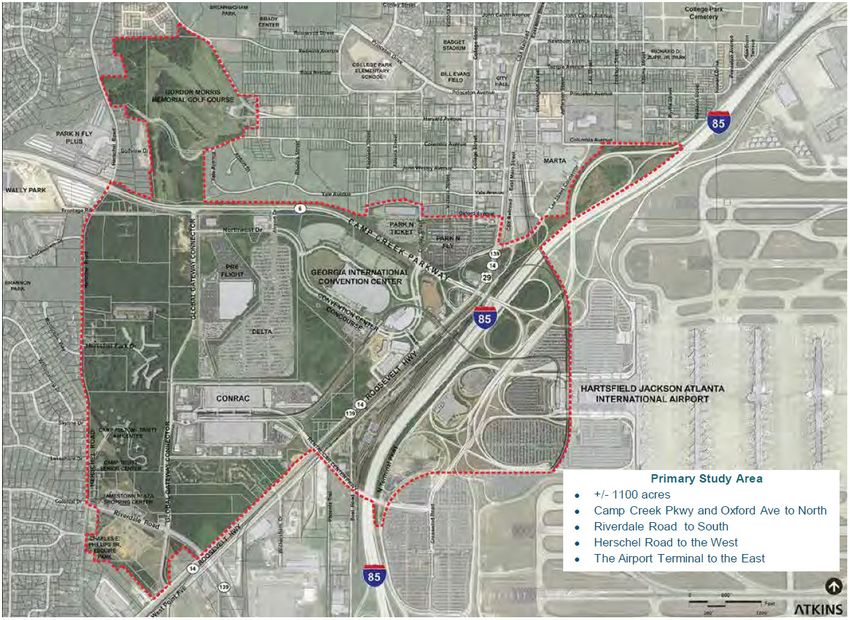
Riverdale Road (SR 139), Roosevelt Highway (US 29/SR 14), Virginia Ave-
nue, Central Avenue (US 19/41/SR 3), and Airport Loop Road, as shown in
Figure 2. The plan also recommends a number of smaller local trails to fill
the larger regional system by connecting residents and visitors to neigh-
borhood schools, community centers, employment, and parks.
To begin implementation of its Greenway Plan, the AACIDs and Aerotropo-
lis Atlanta Alliance (AeroATL) have identified seven priority projects, called
“model miles.” A feasibility study is currently underway to develop site
plans and engineering concepts for model mile segments in the Cities of
Atlanta, East Point, Forest Park, Hapeville, South Fulton and Union City
as well as in Clayton County. All but one of these, the City of Hapeville
segment, are outside of the boundaries of the AACIDs. These projects are
depicted in Figure 3 on the following page. The areas being studied for
model miles include the following locations:
• Atlanta: Adams Park including the area near Adams Park Recreation
Center and Library, Alfred Tulp Holmes Golf Course, Cascade Park, and
Greenwood Cemetery, with potential trail connectivity to Fort McPher-
son, Lee Street Trail, Cascade Springs trails, and the Westside BeltLine.
• Clayton County: Following the Flint River connecting Drew High School,
Riverdale Elementary School, and Southern Regional Medical Center.
• East Point: Promote transit-oriented development around the East
Point MARTA Station connecting Tri-Cities High School to the MARTA
station via the existing pedestrian bridge from the BuggyWorks & Wag-
onWorks buildings.
• Forest Park: Along the Forest Parkway (SR 331) corridor, from east of
I-75 to Ash Street in downtown Forest Park.
• Hapeville: Connecting employers along South Outer Loop Road with a
proposed park as part of the Finding the Flint initiative and a new cycle
track along Doug Davis drive.
• South Fulton: Within a largely undevelopable floodplain and Camp
Creek with potential future connections to the Wolf Creek Amphithe-
atre, Wolf Creek Library, and development along Butner Road.
• Union City: Focused on Royal South Parkway, a predominantly indus-
trial corridor near I-85 and the MARTA Park-and-Ride Lot at Feldwood
Road and potential connectivity to nearby schools and residential areas.
Recommended projects from the AeroATL Greenway Plan include several
segments that have the potential to improve last mile connectivity and
FIGURE 2: AeroATL Greenway Plan Priority Trail Network support access to warehouse and industrial jobs critical to freight and
logistics. Examples of such projects include the Airport Loop along In-
Image Credit: Aerotropolis Atlanta Community Improvement Districts (AeroATL Greenway Plan, p. 125) ner and Outer Loop Roads, the model mile along Royal South Parkway in
Union City, and the model mile along Forest Parkway (SR 331) east of I-75.
6 AEROTROPOLIS ATLANTA FREIGHT CLUSTER PLAN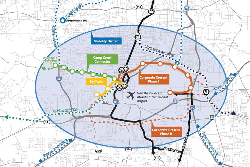
AACIDs Master Plan (2017)                                                       AACIDs Transit Feasibility Study
                                                                            The Aerotropolis Atlanta Master Plan was completed in May 2017 and de-          (2019)
                                                                            fines the challenges and opportunities that will shape $84 million worth
                                                                            of potential investment through 2021 between the two community im-              AACIDs conducted a transit feasibility study that examines existing transit
                                                                            provement districts within AACIDs - Airport West CIDs and Airport South         infrastructure including MARTA and GRTA Xpress along with airport shuttle
                                                                            CIDs. Two clear goals are to enhance brand and perception and to foster         services from hotels and area parking lots. The enhancement of active
                                                                            economic development. Four objectives to attain these goals in the five-        modal infrastructure such as sidewalks, transit stops, and bicycle facil-
                                                                            year action plan are to:                                                        ities is a point of emphasis in this study. MARTA is noted for not having
                                                                                                                                                            continuous operations throughout the week, which does not necessarily
                                                                            • Improve the effectiveness and visibility of public safety                     accommodate alternative work schedules. Bus routes in the Aerotropolis
                                                                            • Simplify the ability to navigate the district through wayfinding and sig-     operate at headways of 20 to 30 minutes with only seven of 24 routes in
                                                                              nage                                                                          the study area operating at peak period headways of 10-15 minutes. Due
                                                                            • Engage in beautification of intersections and corridors                       to space constraints at H-JAIA, intermodal transfers occur in higher vol-
                                                                                                                                                            umes at the College Park MARTA station. Transit markets identified in this
                                                                            • Expand transportation infrastructure connectivity and mobility options.       study include the following:
                                                                            Intersections recommended for beautification within the Aerotropolis as         • Aerotropolis Residents
                                                                            part of this master plan initiative include:                                    • Aerotropolis Employees
                                                                            • I-285 at Riverdale Road                                                       • Aerotropolis Visitors
                                                                            • I-285 at South Fulton Parkway                                                 • Airport Employees
                                                                            • I-85 at Riverdale Road (SR 139)                                               • Airport Passengers (Origin and Destination Businesses and Visitors)
                                                                            • I-85 at Virginia Avenue
                                                                                                                                                            Future development analysis in this study identifies the need for better
                                                                            Corridors emphasized in this report and recommended for potential street-       workforce access to accommodate both existing and future workers and
  FIGURE 3: AeroATL Greenway Model Mile Feasibility Study Segments
                                                                            scape enhancements have the potential to become mixed-use corridors             companies. Sites of development discussed include:
Image Credit: AACIDs Model Mile Request for Proposals                       that provide for work access and recreation include:                            • Airport City: 320 acres of underutilized land directly north of Camp
                                                                            • Virginia Avenue                                                                 Creek Parkway (SR 6) will be master developed by the City of College
                                                                            • Camp Creek Parkway (SR 6)                                                       Park and consist of residential, office, and retail uses. The project is
Other projects that will support workforce access and benefit the freight                                                                                     expected to add more than 5,000 jobs and approximately 10 million
industry include:                                                           • Phoenix Boulevard/Forest Parkway                                                square feet (sf) of new development. Access alternatives proposed by
• FP-1, FP-2, FP-3, and FP-4 – The Forest Park-Fort Gillem Trail            The intersection of Camp Creek Parkway (SR 6) and Washington Road is              the City of College Park include a pedestrian bridge over Camp Creek
                                                                            emphasized as an operational bottleneck, and the project team identifies          Parkway (SR 6) to the Georgia International Convention Center to make
• CC-1 – The Flint River Trail Connection
                                                                            two concepts to improve operations at this intersection:                          connections between the SkyTrain and MARTA.
• CP-1, CP-2, CP-3, and CP-4 – The Herschel Road/Dodson Connector
                                                                            • Installing a left turn at Ale Circle                                          • Fort McPherson: Located to the north of the City of East Point, this mil-
• SF.FC-2 – The Camp Creek Parkway Trail                                                                                                                      itary installation closed in 2005 and is being considered for mixed-use
                                                                            • Installing a landscaped median along Washington Road north of the               redevelopment to include housing, office, retail, and open space. This
• SF.FC-3 – The Welcome All Trail and
                                                                              intersection                                                                    site also is home to the Tyler Perry Film Studios.
• SF.FC-4, SF.FC-5, SF.FC-6 and SF.FC-7 – Roosevelt Highway Trail
                                                                            Pertaining to freight, this plan points out that the Aerotropolis area should   • Cargo City: The relation of H-JAIA's north cargo area and expansion
                                                                            preserve industrial and commercial sites in proximity to H-JAIA and major         of the southern cargo area is creating an opportunity for development
                                                                            transportation thoroughfares. Also, the master plan identifies a needed           that provides access to international freight and facilitate global logis-
                                                                            truck connection between South Fulton Parkway and Camp Creek Park-                tics economy functions.
                                                                            way (SR 6) to alleviate congestion on I-285.                                    • International Gateway: Located directly to the east of the H-JAIA In-
                                                                                                                                                              ternational Terminal, this site contains underdeveloped airport-owned
                                                                                                                                                              land and active shipping and distribution centers.

                                                                                     AEROTROPOLIS ATLANTA FREIGHT CLUSTER PLAN                                                                                                       7
• Greenbriar Transit Center: This is a planned transit hub located north        • South Fulton BRT: The South Fulton BRT is a proposed alignment along
  of AACIDs near the intersection of Langford Parkway (SR 166), Camp-             12 miles of South Fulton Parkway and Roosevelt Highway (US 29/SR
  bellton Road, and I-285. This will serve numerous MARTA routes, includ-         14) from the College Park MARTA station out South Fulton Parkway
  ing Route 83, which has the second highest bus ridership in MARTA's             towards warehouse and distribution facilities near Welcome All Road.
  network and is operating as arterial rapid transit (ART). This ART route        Articulated buses would operate in dedicated lanes along this corri-
  is slated to be converted to light rail along Campbellton Road thanks to        dor. Implementation could take place over three phases: 1) Commuter
  the More MARTA sales tax initiative.                                            Bus with signal improvements; 2) Enhanced Bus with queue jumpers
                                                                                  and signal preemption; and 3) Fixed Guideway Transit with exclusive
The study explores transit solutions including extending existing services,       right-of-way (ROW) along the route. This recommendation builds upon
self-driving transit vehicles, and circulator service. Specific solutions for     the outcomes from the South Fulton Parkway MARTA Study detailed on
enhanced transit service considered as part of this study are depicted in         page 22.
Figure 4 and include:
                                                                                • Clayton County Regional Commuter Rail: Clayton County voters ap-
• Corporate Crescent: The Corporate Crescent concept consists of a                proved a referendum in November 2014 dedicating a one-cent sales
  broad arc that runs across the north side of H-JAIA between the Airport         tax for the expansion of MARTA into the county south towards Lovejoy.
  MARTA Station and the International Terminal, connecting several large          Potential corridors are currently under evaluation, and more informa-
  employers like Delta and Porsche with stops at those locations. It would        tion on this recommendation is included in the Capital and Maintenance
  operate along N. Inner Loop Road, Perry J. Hudson Parkway, Atlanta              Projects section of this Appendix.
  Avenue, S. Central Avenue/Porsche Avenue, and Charles W. Grant Park-
                                                                                • GRTA Xpress: Existing Xpress routes do not currently make pick-ups           FIGURE 4: AACIDs Transit Study Recommendations
  way/Maynard H. Jackson, Jr. Boulevard. The alignment would accom-
  modate airport passengers, Corporate Crescent employees, and other              or drop-offs within AACIDs or at either airport terminal, and this plan
                                                                                                                                                             Image Credit: AACIDs Model Mile Request for Proposals
  visitors and residents. Implementation could begin with either standard         identifies that the State Road and Tollway Authority (SRTA) is currently
  bus lines or "BRT light" service, and after the investment is warranted         undertaking a study to explore the value and operations of expanding
  through ridership, this could become full BRT.                                  operations to include stops at the College Park MARTA station to allow     • First and Last Mile Connectivity Strategies: In addition to investing in
                                                                                  access from Cobb, Coweta, Henry, and Gwinnett counties.                      transit infrastructure, active transportation infrastructure that ensures
• Camp Creek Connector: This route would serve the portion of Camp
  Creek Parkway (SR 6) between the Camp Creek Marketplace shopping              • Intermodal Transportation Center: This recommendation, if fully im-          safety and quality of life should be a priority in the Aerotropolis, and
  center and either the Airport or College Park MARTA Stations. Stops             plemented, would lead to the creation of an intermodal transportation        this is currently being implemented through the AeroATL Greenway
  along this corridor would serve the private airport parking facilities          center (ITC) at either the Airport or College Park MARTA Station to pro-     Plan and the "model mile" initiative stemming from that plan.
  along the corridor and major intersections with Herschel Road, Po-              vide a transit hub which connects multiple transit modes.
                                                                                                                                                             Recommendations stemming from this study are grouped into immediate
  tomac Drive, Washington Road, and Desert Drive. This concept could            • Bus and Shuttle Stop Elements: Bus and shuttle stops are recom-            actions, short-term actions, and long-term actions. The delivery of these
  be implemented as BRT light and eventually become bus rapid transit             mended to have design elements that positively affect the passenger        recommendations depend on potential partnerships, governance, funding,
  (BRT) depending on demand and ridership.                                        experience, convey information, and provide seamless operations. This      ownership and operations models across agencies, and technical capabil-
• Mobility District: Since transit operations are not currently 24/7 oper-        recommendation would improve pedestrian connectivity and improve           ities. Actions by term are shown in Table 1. Immediate actions include the
  ations in the Aerotropolis, this recommendation calls for the creation          safety and security around the Aerotropolis. These elements depend         following:
  of a Mobility District within the Aerotropolis where transit options are        upon ridership and MARTA service standards.
                                                                                                                                                             • Implementation of a 24/7 mobility district
  available 24/7. Alternatively, travelers can call for transit rides during    • Signage and Wayfinding: Similar to recommendations presented in the
  those hours where MARTA and GRTA services are not operating. This               AACIDs Master Plan, this plan recommends wayfinding within the Aero-       • Provide high quality bus stops and shelters
  has the potential to benefit employees who work in the Aerotropolis             tropolis through unique branding and to implement on multiple modes        • Collaborate with agencies to advance first/last-mile upgrades
  along with residents and visitors.                                              including transit, walking, and bicycling.
                                                                                                                                                             Short-Term Actions include the following:
• Riverdale ART: This recommendation focuses on Route 196 (Upper Riv-           • Transit Technologies: This recommendation would bolster existing in-
  erdale). AM and PM peaks for this route reflect the reliance upon this          frastructure through MARTA and SkyTrain by investing in and imple-         • Clayton County Regional Commuter Rail
  route to access jobs within the Aerotropolis. The plan recommends re-           menting infrastructure that supports automated people movers (APMs),       • Corporate Crescent Circulator
  ducing peak headways and implementing treatments such as lead pe-               autonomous vehicles (AVs), low-speed electric vehicles (LSEVs), person-
                                                                                                                                                             • GRTA Xpress
  destrian interval signal timing and improved medians. As of this plan's         al rapid transit (PRT), and Maglev technology.
  publication, Riverdale Road was being considered for full BRT upgrades.                                                                                    • Camp Creek Connector
                                                                                                                                                             • Riverdale Road ART

 8                                                                                       AEROTROPOLIS ATLANTA FREIGHT CLUSTER PLAN
Long-Term Actions include the following:                                                  Programmed short-term freight projects within the study area include:
• Camp Creek Connector                                                                    • Interchange Improvements at I-85 at Senoia Road (SR 74)
• Corporate Crescent Circulator                                                           • Camp Creek Parkway (SR 6) Diverging Diamond Interchange with I-285
• GRTA Xpress                                                                               (Ongoing)

• South Fulton BRT                                                                        • I-75 Collector and Distributor Lanes from Forest Parkway to I-285
                                                                                            (Northbound Ongoing; Southbound Programmed)

ARC Freight Mobility Plan (2016)                                                          Freight projects are grouped as either Tier 1 or Tier 2 projects for this plan
                                                                                          update. Tier 1 and Tier 2 freight projects are identified in this plan, but
The Atlanta Regional Commission (ARC) Freight Mobility Plan was pre-                      there are no Tier 2 projects within AACIDs. Tier 1 freight projects relevant
pared in May 2016. It focuses on creating a framework for enhancing the                   to the Aerotropolis include the following:
movement and transport of consumer goods through the Atlanta region,                      • Camp Creek Parkway (SR 6) Widening from I-285 to I-85
improving economic competitiveness, and minimizing environmental and
community impacts. This plan was an update of the 2008 ARC Freight Mo-                    • Interchange Improvements at I-285 and Washington Road
bility Plan. It identifies Atlanta as among the top 15 manufacturing centers              • I-85 South Collector-Distributor Lanes from SR 74 to Collinsworth Road
by employment in 2013 where it was ranked 11th. Freight industry output                   • Widen outside lane on Camp Creek Parkway (SR 6) and install ITS truck
is expected to more than double for Metro Atlanta from $184 billion in                      sensors at five locations
2012 to $407 billion in 2040. Freight in terms of truck, air, marine, and
rail is discussed along with the percentage contribution of each to Metro                 • Install variable message signs on Camp Creek Parkway (SR 6) at I-285
Atlanta’s freight tonnage and traffic. ARC’s Freight Vision is established as
one where “Metropolitan Atlanta will win the future, remaining and grow-                  ARC Policy Framework (2015)
ing as the capital of the South by sustaining our stature through industry,
trade, and cultural vitality, and by serving the people through enhance-                  The Atlanta Regional Commission’s Policy Framework is the portion of the
                                                                                          Atlanta Region’s Plan that provides a focus on a threefold vision for the           FIGURE 5: Threefold Framework of The Atlanta Region’s Plan
ment of our role as a global hub for goods, services, and enterprise.”
                                                                                          Atlanta Region’s Plan (see Figure 5) that consists of providing world-class       Image Credit: Atlanta Regional Commission, https://www.atlantaregionsplan.org/
Within the Aerotropolis, I-285 near Washington Road is listed as a top-5                  infrastructure, building a competitive economy, and ensuring that the At-
truck count location along an interstate in the Atlanta region. The airport               lanta region contains healthy and livable communities. The framework en-
area is defined as a major freight activity cluster in this document. The
Airport/Clayton cluster has the second highest percentage of vacant in-
                                                                                          visions Atlanta as a globally recognized hub of innovation and prosperity
                                                                                          by emphasizing freight, start-up businesses, and the film industry. It also
                                                                                                                                                                            The Atlanta Region’s Plan –
dustrial properties behind the Fulton Industrial Boulevard cluster. A high                strives to ensure a comprehensive transportation network that incorpo-            Transportation (2018)
number of truck trips end east of the airport near the Norfolk Southern                   rates regional transit, 21st century technology, the application of real-time
Forest Park Yard based on the analysis conducted as part of this study.                   and advanced technology, and promoting trip reliability and system resil-         The Atlanta Region’s Plan contains a transportation element which serves
Some areas with heavy delay include the I-75 at I-285 junction, US 19/41                  iency for all modes of travel. Other policies relevant to freight clusters and    as the long-range transportation plan for the metropolitan Atlanta re-
through Hapeville, and SR 74 near its interchange with I-85. Reliability                  movement within this document include:                                            gion spanning to 2040. It envisions approximately $93.6 billion in proj-
during peak travel varies by corridor within the study area; freeway routes               • Maintain and improve the economic viability and accessibility of key            ects overall (accounting for inflation) and includes several express lane
to the south and east of the airport tend to provide lower reliability. Sever-              intermodal freight facilities                                                   freeway projects, rail and bus rapid transit networks, a regional bicycling
al corridors in the study area have a high number of truck-involved crash-                                                                                                  and walking network, commitment to the Livable Centers Initiative (LCI)
es including Tara Boulevard (US 19/41/SR 3), Forest Parkway (SR 331),                     • Provide safe and reliable access to freight land uses and major inter-
                                                                                                                                                                            program, and new lane miles – all aimed to reduce greenhouse gas emis-
and Camp Creek Parkway (SR 6).                                                              modal freight facilities
                                                                                                                                                                            sions in the Atlanta region. H-JAIA is identified as the Atlanta region’s
                                                                                          • Promote the use of information technologies to foster the most efficient        greatest economic infrastructure asset with a direct economic impact of
                                                                                            movement of freight                                                             $32.5 billion, and it is the busiest airport in the world for passenger traffic
                                                                                          • Preserve industrial land uses in proximity to existing freight corridors        and twelfth busiest nationally for cargo hauled.1 The Atlanta region ranks
                                                                                                                                                                            as the nation’s seventh largest freight market. A 56 percent increase in
                                                                                                                                                                            freight traffic is forecasted through 2040.

1      Hartsfield-Jackson Atlanta International Airport (2019). Air Service Development. Retrieved from http://www.atl.com/business-information/air-service-development/.

                                                                                                    AEROTROPOLIS ATLANTA FREIGHT CLUSTER PLAN                                                                                                                9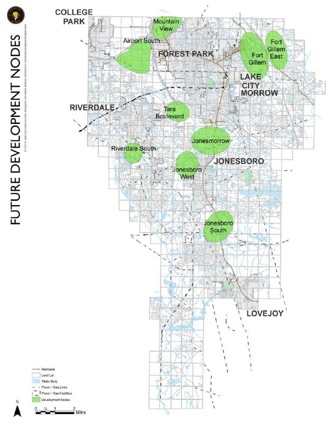
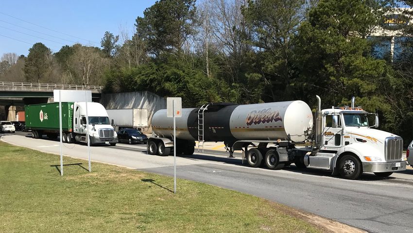
The plan outlines objectives for the Atlanta region including supporting      • A bridge upgrade project spanning 0.4 miles along Roosevelt Highway          ducted as part of this study revealed that no public truck parking (i.e. op-
the reliable movement of freight and goods. Within this objective are three     (US 29/SR 14) at the CSX rail line is estimated to cost $3.05 million with   erated by GDOT) is located in the Aerotropolis. However, there are private
policies:                                                                       construction programmed for FY2022.                                          truck parking facilities within the Aerotropolis. Due to this lack of public or
• Provide safe and reliable access to freight land uses and major inter-      • The widening of Buffington Road between Rock Quarry Road and Roo-            private truck parking, illegal parking is a common problem in the Atlanta
  modal freight facilities                                                      sevelt Highway (US 29/SR 14) is estimated to cost $31.39 million with        region, including the Aerotropolis. This problem was especially apparent
                                                                                construction programmed for FY2021.                                          along interstate ramps, vacant and abandoned lots, and road segments
• Promote the use of information technologies to foster the most effi-                                                                                       within industrial parks. A truck parking supply and demand analysis was
  cient movement of freight                                                   • South of the airport, SR 85 is slated to be widened between Adams            conducted for this study and reveals that all freeway corridors in the At-
• Preserve industrial land uses in proximity to existing freight corridors      Drive and I-75 from four to six lanes. The project spans 3.1 miles and       lanta region will have a deficit of public parking while all but three free-
                                                                                has an estimated completion date of 2030. The $17.4 million project          way corridors (excluding I-85 south of I-285) will have a deficit of private
These policies shall be accomplished by continuing to promote and en-           will also include an interchange at Forest Parkway (SR 331) near the         parking by 2045.
hance rail safety, collecting more data on tracks and bridges, hazardous        junction with I-75 at Exit 237.
materials, and grade crossings, collaborating with neighboring states on      • Interchange ramp modifications and collector-distributor lanes between       Recommendations relevant to this Freight Cluster Plan include:
regional solutions to freight challenges, increasing goods movement by          Northbound I-75 and Forest Parkway are currently under construction          • Adding and expanding truck parking supply
rail through short-line upgrades, removing key freight bottlenecks, and         at a cost of $75 million. The southbound collector-distributor lanes that
improving grade crossings, improving last-mile connections to intermodal                                                                                     • Developing truck parking policies and partnerships
                                                                                will complement this project are currently under scoping.
facilities, and modernizing the system to accommodate stringent freight                                                                                      • Improving information sharing through real-time technology and clear-
standards. The plan discusses freight cluster area master plans (such as      Other TIP projects, along with their assigned GDOT PI number, are outlined       inghouses
this one for AACIDs) to serve regional planning efforts in Atlanta.           within the Capital and Maintenance Projects section of this Appendix.          • Monitoring and integrating future technology developments with dock
Long-range projects outlined within this document are detailed in the                                                                                          management and automation
Capital and Maintenance Projects section of this Appendix.                    ARC Truck Parking Study (2018)                                                 Action Item 1.2 in this study calls for sub-area or freight cluster plans
                                                                              The Atlanta Regional Truck Parking Assessment Study was sponsored by           in locations with clusters of industrial development to address transpor-
ARC TIP FY2018-2023 (2018)                                                    ARC and completed over a span of nine months, ending in April 2018. The        tation planning, traffic analysis, and related local and regional planning
                                                                              study is the result of a recommendation from the 2016 Atlanta Regional         goals. These freight cluster plans should identify locations where trucks
The Transportation Improvement Program (TIP) is a short-term transporta-      Freight Mobility Plan Update. The study area consisted of the twenty Met-      may be parking illegally in the study area and focus on truck staging
tion plan for a metropolitan planning organization (MPO). The Atlanta Re-     ro Atlanta counties along with key adjacent counties. Outreach consisted       needs for pickup/delivery at warehouses and distribution centers.
gional Commission (ARC) is the federally designated MPO for the Atlanta       of presentations at various meetings of ARC bodies including the Freight
region and encompasses 20 counties. The FY2018-2023 TIP for Atlanta
runs from Fiscal Year (FY) 2018 to FY 2023 and includes several projects in
                                                                              Advisory Task Force, the Transportation Coordinating Committee, and Land       Atlanta Strategic Truck Route Master
                                                                              Use Coordinating Committee. Surveys were distributed online to stake-
the Freight Cluster study area, including the Clayton County high-capacity    holders such as truck stop owners, trucking companies, local jurisdictions     Plan (2010)
transit initiative to expand Metropolitan Atlanta Rapid Transit Authority     and community improvement districts (CIDs), and law enforcement.
(MARTA) service southward towards Lovejoy. The TIP programs $300 mil-                                                                                        The Atlanta Strategic Truck Route Master Plan (ASTRoMaP) was produced
lion for Clayton County MARTA expansion with $135 million derived from        Top issues identified in the study include limited truck parking, illegal      in response to a recommendation from the 2008 ARC Freight Mobility
federal funding sources.                                                      parking on private property or freeway shoulders and ramps, safety and         Plan to further develop the Regional Freight Priority Highway Network
                                                                              aesthetics, and noise. These issues are especially exacerbated along the       (RFPHN). This master plan consisted of designing a truck route system
Other key projects that are programmed within the study area include the      I-285 corridor, based on quantitative analysis and stakeholder feedback.       that provides regional access and will guide current and future decision
following:                                                                                                                                                   making. The project incorporated outreach programs and data collection
• Funding has been allocated for $8.02 million of Downtown East Point/        Among the 277 responses from a truck driver survey, approximately 70           in developing this network along with an environmental justice and land
  MARTA station multi-modal improvements. The project involves the re-        percent of truck drivers responded that they simply drive until a safe park-   use review. Key findings include the need for more freight integration
  duction of travel lanes on Main Street from four to three lanes.            ing location is found. However, 55 percent of respondents stated they use      into the needs assessments of local jurisdictions as comprehensive land
                                                                              a smartphone app and 47 percent of respondents determine parking lo-           use and transportation plans had largely neglected adequately addressing
• The Global Gateway Connector is a bicycle and pedestrian trail between      cations ahead of time. Other drivers may simply drive further, and this can
  the SkyTrain and downtown College Park that will cost approximately                                                                                        the needs of a growing volume of freight movement through the region’s
                                                                              potentially be against Federal Highway Administration (FHWA) regulations       communities. The plan considers bridge weight restrictions, at-grade rail
  $7.34 million. A majority of the cost of this project stems from the con-   on daily driving limits, driving windows, and rest breaks. A high percentage
  struction of a pedestrian bridge over Camp Creek Parkway (SR 6).                                                                                           crossings, land use and concentration of freight destinations, crash histo-
                                                                              of drivers perceived that parking was not available on freeway corridors       ry, existing roadway conditions, and model outputs. Each roadway in the
                                                                              within the Aerotropolis, such as I-285. An inventory of truck parking con-     RPFHN was scored according to a Criteria Matrix.

 10                                                                                    AEROTROPOLIS ATLANTA FREIGHT CLUSTER PLAN
Boulevard CID Master Plan (2013)
The Boulevard CID serves the Fulton Industrial Boulevard corridor between
Campbellton Road to the south and the Fulton County Airport-Brown Field
to the north (see Figure 7). The CID exists to revive the area’s industrial
output and employment. A majority of this CID is located to the west of
the Aerotropolis Freight Cluster study area, but it is still relevant to exam-
ine as heavy volumes of goods are transported between Fulton Industri-
al Boulevard (SR 70) and H-JAIA through multiple area routes, including
Camp Creek Parkway (SR 6). Growth and expansion at H-JAIA is having a
spillover effect into this industrial corridor. This Master Plan was complet-
ed in 2013 and serves as a 5-year blueprint for the CID.
Recommendations stemming from this report include:
• Wayfinding and branding
• Transportation investments and enhancements to suit freight and
multi-modal mobility needs
• Landscape elements in public right-of-way
• Sustainability features
The Fulton Industrial corridor has numerous railroads, and Camp Creek
Parkway (SR 6) and Fulton Industrial Boulevard (SR 70) are characterized
by high truck traffic. The predominant land use is warehousing, and future
industrial development opportunities are concentrated at the south end of
the corridor. It recommends short-term improvements to the intersection
of Fulton Industrial Boulevard (SR 70) at Camp Creek Parkway (SR 6). Fur-
ther, this plan recommends revising the Fulton County zoning ordinance to
allow for consistent development and prohibit non-compatible land uses. FIGURE 7: Boulevard CID Master Plan Study Area
Cargo Atlanta Freight Study (2015) Image Credit: Boulevard Community Improvement District (Fulton Industrial Boulevard
CID Master Plan Introduction, p. 1-3)
The Cargo Atlanta Freight Study is a freight assessment report completed The study includes project recommendations such as:
by the City of Atlanta’s Office of Planning (now known as the Department • Cargo facilities on the south side of the airport
of City Planning) in 2015 and stems from the city’s previous transportation
• Effective wayfinding and signage
plan, the Connect Atlanta Plan (2008). The study explores all modes of
FIGURE 6: ASTRoMAP System freight in the City of Atlanta and develops programs, policies, and projects • Coordination with GPS providers
that will help improve freight movement thorough the City. • Creating an industrial fund to buy, restore, and resell industrial land
Image Credit: Atlanta Regional Commission (Atlanta Strategic Truck Route Master Plan
Final Report, p. 9-7) The City sought to align itself with state and federal planning documents • Restricting truck access to Downtown Atlanta
and regulations in determining policy direction and identifying the needs
From the findings of this scoring process, a “grid” network of appropriate and opportunities pertaining to freight within the city limits and imme-
corridors was identified consisting of a network of north-south and east- diate surroundings. As the City of Atlanta operates H-JAIA, this study is
west connectors totaling 1,378 miles. A map of this network is included important to acknowledge and review. The study culminated in the devel-
in Figure 6. opment of a freight route map for the City of Atlanta (shown in Figure 8
on page 12).
AEROTROPOLIS ATLANTA FREIGHT CLUSTER PLAN 11Cargo Atlanta Health Impact City of Atlanta Transportation Plan
Assessment (2016) (2018)
This document is a Health Impact Assessment (HIA) of the Cargo Atlanta The City of Atlanta updated its comprehensive transportation plan in 2018
Freight Study that was jointly completed by the Center for Quality Growth (its previous was Connect Atlanta released in 2008) to incorporate the
and Regional Development at the Georgia Institute of Technology and access strategy for Atlanta City Design and to integrate transportation
the Georgia Health Policy Center at Georgia State University in December investments with the City’s vision for inclusive growth. Goals for the City’s
2016. HIAs identify the health consequences of new policies and devel- transportation system focus on safety, mobility, and affordability. The plan
ops practical strategies to enhance their health benefits and minimize includes information on demographics, high injury intersections, and tran-
adverse effects through the lenses of equity, air quality and emissions, sit, bicycling and walking conditions throughout the city. The plan itself
demographics, transportation and land use. This publication identifies sev- mentions little about freight; however, it acknowledges the Cargo Atlanta
eral key issues with respect to freight movement in the City of Atlanta Freight Study that was completed in 2015 as part of the prior plan review.
including encroachment between industrial and residential areas and a
growing city population. It also discusses the economic benefits of freight As part of the Atlanta City Design, growth areas are established along cer-
movement including increased employment opportunities. This report dis- tain corridors and labeled as either city design growth areas, high growth
cusses noise and air pollution and emissions along with crashes and safe- areas, or emerging growth areas. Growth areas within the City of Atlanta
ty at various sites with high freight activity such as airports, highways, that are in close proximity to the Aerotropolis include the following:
truck stops, and railroad lines. The report found that particulate matter is • Metropolitan Parkway (US 19/41/SR 3) - City Design Growth Area
the most prevalent concern at ground level at and around H-JAIA, and a • Jonesboro Road (SR 54) - City Design Growth Area
strong correlation exists between this and low-income population as well
as premature death. It also includes recommendations on advisory buffers • Fort McPherson - Emerging Growth Area
for freight facilities. This plan impacts freight from a workforce access standpoint by identify-
The HIA recommends that the City of Atlanta should approach all freight ing shortcomings in the existing multi-modal network and outlining how
projects proposed in the Cargo Atlanta study by doing the following: to address them over the next five years. The five-year action plan in-
cludes 20 programs and 200 projects that are intended to improve access,
• Consider surroundings comprehensively at the earliest stage possible connectivity, and safety across the City of Atlanta. Projects stemming from
including population demographics, existing land uses, and population this plan update were labeled as either low, medium, or high priority. No
health characteristics along with all modes of freight. corridor-specific low priority projects were identified within the Aerotrop-
• Encourage freight facilities in the city boundaries to adopt low-pollution olis. Medium-priority projects near the Aerotropolis that will benefit the
on-site drayage trucks, locomotives, and equipment handlers to reduce freight industry include:
on-site air pollution emissions. • EX-005 (I-285 and Langford Parkway Interchange Reconfiguration):
• Industrial activity should be clustered in established industrial zones Reconstruction of interchange, involving removal of east-bound ramp
and not encroach on residential areas, and residential development to Langford Parkway (SR 166) from NB I-285. This plan may evolve with
FIGURE 8: City of Atlanta Freight Route Network
should be discouraged along freight routes that connect industrial clus- the City of Atlanta's updates to the Greenbriar LCI Study in 2017.
ters with interstate highways and other area freeways. • ST-041 (Langford Parkway Study): This project entails studying the
Image Credit: City of Atlanta (Cargo Atlanta Freight Study, Appendix E) • Buffers should be established to mitigate noise and air pollution effects most efficient and cost effective long-term fate of Langford Parkway
stemming from freight infrastructure and the report recommends ide- (SR 166) from I-285 to Lakewood Parkway. This could include conver-
al buffers of 500 feet, 1,000 feet and 1,312 feet for rail corridors, rail sion to an urban boulevard.
yards, and freight corridors, respectively.
• Trees should be planted in these buffers to help ease pollution effects.
• The industrial tax base needs to be maintained while the zoning code
should be reviewed to address conflicts between industrial and residen-
tial land uses.
12 AEROTROPOLIS ATLANTA FREIGHT CLUSTER PLANHigh-priority projects near the Aerotropolis that will benefit the freight cant buildings and older developments that comprise 80 acres of greyfield • ED-2: Encourage economic development, with an emphasis on redevel-
industry include: sites may present opportunities for redevelopment along corridors such opment.
• BI-010 (Sylvan Road Bike Facilities): Re-stripe the existing 30-foot, as Old National Highway (SR 279). • ED-3: Accommodate new development while enhancing existing local
two-lane roadway from Murphy Avenue to Lakewood Avenue to include The City strives to work with AACIDs in creating the “Airport City” concept assets.
a combination of 5-foot bike lanes (designed to coordinate with bus op- referenced in the Aerotropolis Blueprint (2016). The City is also located • ED-4: Promote public-private partnerships to enhance activity centers
erations), sharrows, and 10-foot vehicular lanes with on-street parking along a CSX rail line. The plan discusses the airport’s desire to grow its and corridors.
located along redevelopment frontages. cargo facilities along with the need for coordination in freight planning. • ED-7: Target reinvestment in declining neighborhoods and corridors to
• BI-020 (Lee Street Trail): New multi-use trail along the eastern side The Roosevelt Highway (US 29/SR 14) corridor is envisioned as a poten- further encourage private sector redevelopment and accommodate fu-
of Lee Street (US 29/SR 14) between the West End and Lakewood/ tial distribution and logistics center. Entries in the City's community work ture
Fort McPherson MARTA Stations (Ralph David Abernathy Boulevard to program which are relevant to AACIDs and the freight industry include:
Womack Avenue). The trail is adjacent to the railroad ROW and MARTA • NCR-9: Preserve and protect existing historic residential and commer-
• Working with MARTA on TOD access to the College Park MARTA Station cial structures adding to the social and cultural fabric of the city.
north-south line. This project serves three MARTA rail stations and the
Fort McPherson redevelopment site. • Support AACIDs and the AeroATL • CF-4: Protect investments in existing infrastructure by encouraging in-
• SA-001 (Southside Industrial Parkway Widening): Widen Southside • Create tax allocation district (TAD) on Old National Highway (SR 279) to fill, redevelopment, and compact development.
Industrial Parkway from Browns Mill Road to Jonesboro Road (SR 54) to spur redevelopment • CF-7: Establish regulations such that new development does not create
create a consistent cross section through the Southside Industrial Park • Implement Fulton County T-SPLOST Projects (specific projects discussed a burden but rather provides the improvements and/or infrastructure
including truck route wayfinding signage to discourage trucks from us- in the Capital and Maintenance Projects section of this Appendix) necessary to support it.
ing nearby neighborhood streets,sidewalks on both sides of the street, • Old National Highway (SR 279) Transit Oriented Sidewalk Installation • CF-9: Establish regulations such that new development does not create
ADA compliant ramps, push buttons, and crosswalks. a burden but rather provides the improvements and/or infrastructure
• Godby Road Widening
• SA-032 (Cleveland Avenue Multimodal Street Reconstruction): Wid- necessary to support it.
en sections of Cleveland Avenue from Springdale Road to Jonesboro • Camp Creek Parkway (SR 6) Frontage Road Bridge Replacement
• LU-2: Promote development that is sensitive to the land and gives con-
Road (SR 54) and reconfigure to include bicycle lanes. Install sidewalks • Camp Creek Parkway (SR 6) Widening sideration to adjoining, existing and planned development as well as
and other pedestrian improvements. the overall community.
• TR-013 (Cleveland Avenue High Capacity Transit): High capacity tran- City of East Point Comprehensive Plan • LU-3: Promote efficient use of land by promoting well-designed, more
sit along with physical street changes to improve stop amenities, pro-
vide queue jumps and other operational improvements, and to enhance (2017) pedestrian-friendly development patterns with a mix of uses and an
efficient, creative use of land.
pedestrian facilities from Jonesboro Road and Browns Mill Road to East
Point MARTA Station. The City of East Point updated its comprehensive plan in 2017 to identify • LU-5: Guide or direct patterns of land development with land develop-
issues and opportunities for the next five, ten, and twenty years. The plan ment regulations.
• TR-016 (Northside Drive/ Metropolitan Parkway High Capacity Tran- emphasizes the close proximity of East Point to H-JAIA and how freight
sit): High capacity transit from Mount Zion Road (Atlanta city limit) to • LU-7: Encourage innovative land use planning techniques to be used
and industry are strong sectors in the city’s economy. The plan discusses in building higher density and mixed use developments as well as infill
the Arts Center MARTA Station along the Northside/Metropolitan corri- the need for reinvestment in industrial greyfield sites along with a “con-
dor and 17th Street. developments.
flict of scale” between hosting industrial uses with freight truck activity
and the city’s goal of compact, pedestrian-friendly, mixed-use infill devel- • LU-8: Commit to redeveloping and enhancing existing commercial and
City of College Park Comprehensive opment. The plan strives to improve multimodal and pedestrian connec- industrial areas.
• LCI-1: Utilize land served by MARTA rail transit parking lot for higher
Plan (2016) tivity, especially in its downtown area, while continuing to attract industry
to the city, and while doing so, improve the balance between these needs. density, mixed-use development.
The City of College Park Comprehensive Plan was updated in 2016 to Policies stemming from this comprehensive plan address economic de- • LCI-7: Examine parking requirements for all uses. Excessive parking re-
identify issues and opportunities pertaining to housing, economic devel- velopment (ED), community facilities (CF), land use (LU), the Main Street quirements increase the cost of development, harm the environment,
opment, transportation, and land use as required by the Georgia Depart- Corridor TOD Plan LCI (LCI), transportation (T), intergovernmental coordi- and use valuable land. Minimum requirements for off-street parking
ment of Community Affairs (DCA) over the next 20 years. The community nation (IC), and population (P). Those policies that are applicable to freight should be eliminated in the downtown area, and reduced elsewhere
has a goal to capitalize on its location close to H-JAIA, multiple interstate include: in the study area, to promote compact redevelopment/infill, to reduce
highways, and near industrial and warehousing districts of paramount development costs, and to encourage the use of alternative modes of
importance to the freight and logistics industry. One of its challenges, travel.
however, is to mitigate noise pollution stemming from the airport. Va-
AEROTROPOLIS ATLANTA FREIGHT CLUSTER PLAN 13• T-1: Improve connectivity between road networks, public transit, and
pedestrian/bike paths.
City of East Point Main Street TOD
• T-6: Ensure that vehicular traffic will not harm the residential nature of (2012)
neighborhoods.
This June 2012 publication was funded through an LCI grant. The City of
• T-7: Encourage high or urban density to be located in areas that are
East Point strives to change the character and function of its downtown
conducive to walking and biking and are served by transit.
area and Main Street Corridor towards transit-oriented development (TOD).
• T-8: Improve access for disabled persons to public facilities, commercial The TOD Plan guides new development that fosters sustainable land use
districts, parks, schools, etc. and transportation practices while stimulating economic growth. Recom-
• T-9: Promptly address roadway safety issues, and maintain and improve mendations for this TOD Plan were framed in seven focus areas that each
roadway safety features such as regulatory signs and roadway striping. present different opportunities and constraints for growth, housing choic-
es, transportation connectivity, and urban design enhancements. Most of
• T-10: Coordinate with adjacent jurisdictions on bicycle and pedestrian
these relate to bikeability, walkability, and traffic calming measures. One
facility planning to maximize connectivity and efficiency.
of the prominent needs in East Point is additional east-west connectivity
• IC-1: Establish coordination mechanisms with adjacent local govern- across freight rail lines and the MARTA rail line, which run parallel to each
ments to provide for exchange of information, particularly within the other through Downtown East Point. The key location identified in this
Tri-Cities area. plan was East Ware Avenue at Main Street where a new pedestrian bridge
• IC-8: Coordinate with the City of Atlanta and Fort McPherson Redevel- was proposed over the freight rail line, MARTA line, and Main Street.
opment Authority to identify potential impacts of the base redevelop-
Recommendations and design concepts from this study were presented at
ment and maximize redevelopment opportunities affecting both adja-
a focus area level. These are depicted in Figure 9 and include:
cent neighborhoods and the broader East Point market area.
• Village North: Located along Langford Parkway (SR 166), this area is
• IC-11: Participate in the Aerotropolis Alliance and Atlanta Aerotropolis
primarily single-family development and land uses here are intended
CID’s efforts to encourage and improve coordination on land develop-
to promote the redevelopment of Fort McPherson. Infill development is
ment, planning, aesthetic and transportation improvements, and eco-
encouraged in this focus area.
nomic development around H-JAIA
• Neighborhood Live/Work: This district is focused along Church Street
• IC-12: Work with MARTA, GRTA, and ARC to support existing and future
and is adjacent to downtown and is primarily transitional between com-
transit service in and around the city.
mercial retail and single-family residential.
• P-3: Housing, land use, transportation and economic development pol-
• Historic Character Downtown: Downtown East Point is home to a mix
icies will aim to create conditions that allow mixed-income housing op-
of land uses, and a priority of this TOD plan is to enhance bicycle and
portunities, access to job training facilities, and community supported
pedestrian connectivity within this district.
service provision for those in need.
• Gateway North: This area serves as a transition between the Historic FIGURE 9: East Point TOD Focus Areas
Future development goals stemming from the City of East Point's future Character Downtown and the Technology and Research focus areas,
land use character areas are addressed as part of this comprehensive and between Main Street and the Frog Hollow residential neighborhood. Image Credit: City of East Point (Main Street Corridor TOD Plan, p. 80)
plan update. This includes corridors and gateways, and the plan includes
• Gateway South: This is the gateway into Downtown East Point along
language on commercial corridors that should enable shared access and
Main Street (US 29/SR 14) from College Park. This district is proposed
parking as well as contain wide sidewalks in good condition. The commu- The five-year action plan for this LCI study contains numerous streetscape
to primarily consist of commercial retail and institutional uses.
nity work program includes the following that address freight: and multimodal projects that can improve access to jobs within freight-in-
• Technology/Research District: Focused on parcels along Lawrence tensive industries. These include:
• Identify and implement a capital improvement project along Cleveland
Street, this is an employment center with high-tech industrial and office
Avenue • O-11: Partner with Metro Atlanta Chamber of Commerce and Georgia
uses within close proximity to Downtown East Point.
Research Alliance to attract technology-oriented businesses
• Coordinate with AeroATL Greenway Plan
• Historic Warehouse District: This focus area is located to the east of
• O-15: Install pedestrian and bike amenities (benches, bike racks, etc.)
• Downtown East Point Multimodal Improvements Downtown East Point and is ideally suited for office and residential
along major corridors in the study area
• Implement Fulton County T-SPLOST projects uses.
• O-26: Develop a comprehensive pedestrian lighting plan for downtown.
14 AEROTROPOLIS ATLANTA FREIGHT CLUSTER PLANYou can also read