Received 20th February 2022; Accepted 24th March 2022; Published online 15th April 2022 - Research Article
←
→
Page content transcription
If your browser does not render page correctly, please read the page content below
International Journal of Science Academic Research
Vol. 03, Issue 04, pp.3688-3694, April, 2022
Available online at http://www.scienceijsar.com ISSN: 2582-6425
Research Article
ON GEOGRAPHICAL PUBLICATIONS IN GERMANY IN THE 19th CENTURY ACKNOWLEDGMENT OF
THE STATE OF VIETNAM'S OWNING OF THE PARACEL ISLANDS IN 1816
1,
*Dr. Nguyen Thanh Minh and 2Master Tran Ngoc Giap
1
Km No. 1, Ha Tri street, Ha Cau ward, Ha Dong district, Hanoi city, Vietnam
2
Km No. 1, Nguyen Trai street, Ha Cau ward, Ha Dong district, Hanoi city, Vietnam
Received 20th February 2022; Accepted 24th March 2022; Published online 15th April 2022
Abstract
In order to contribute to enriching historical documents with international legal value to prove Vietnam's legal sovereignty over geographical
features in the Hoang Sa and Truong Sa archipelagoes, in this article we select select and provide readers with content and accompanying
illustrations of publications in Germany in the nineteenth century referring to the state's official possession of the Paracels and Spratlys in 1816
of the king of Vietnam and has been recognized by the international community. Publications on this subject are divided into three types:
translations from works outside Germany; Geography edition of German scholars and German encyclopedia edition.
Keywords: Publication, geography, recognition, sovereignty, Hoang Sa.
INTRODUCTION The islands are mostly small, steep, barren, covered with
jungle and uninhabited. Pulo-Ubi and Quadrole [the name of
Publication translated from work outside the German PhuQuoc island used on some ancient maps] are the largest
territory that recognized the Vietnamese king's legal islands mentioned in the previous section. On the chinesischen
possession of the Hoang Sa - Cat Vang archipelago in 1816 Gewässern [Chinese sea/East Sea], the most important islands
of the cochin-chinesischen [Cochin China] are Pulo-Condore
One of the geographical publications from abroad translated [Con Lon/Con Dao], Pulo-Canton [Ly Son island], rather Col-
and published in Germany soon recognized the fact that the lao-Ray [Cu Lao Ray/Ré], and Cham-col-Lao, are actually
Vietnamese king took possession of the Paracel Islands in Col-lao-Cham [Cu Lao Cham]. Everything I know about them
1816 without any international disputes as public. John has been mentioned. In addition to these islands, in 1816,
Crawfurd's famous work2 was translated from English3 into König von Cochin-China [king of Cochinchina/Vietnam] took
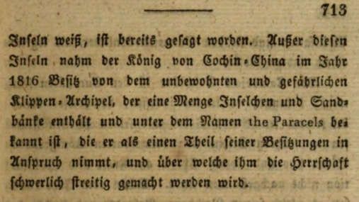
German under a more concise title than the original: Tagebuch possession [sic: Besitz] of the craggy and uninhabited
der Gesandtschaftan die Höfe von Siam und Cochin-China4 archipelago, consisting of countless a number of small islands
[Diary of Ambassadors to the Siamese Courts and and sandbars, known as the Paracels [Paracels, including the
Cochinchina/Vietnam], published in the city of Weimar [in Spratlys], which the king claimed as his sovereignty and which
modern-day Thuringia, Central Germany] 5 in 1831. are unlikely to be contested”6.
In “Sechzehntes Capitel” [Chapter 16]: “Geographie von
Cochin-China. -Gränzen. -Flüsse und Kusten. -
Civilabtheilungen. - Kamboja. –Champaoder Loi. -Ausländer,
welche in Cochin-China wohnen. -Clima. -Mineralische und
vegetabilische Erzeugnisse. -Thiere” [Geography of
Cochinchina/Vietnam, limits, rivers and coasts, administrative
regions, Cambodia, Champa or Loi, foreigners in Cochinchina,
climate, minerals and vegetation, animals], from pages 700 to
738, King Gia Long's possession of the Paracel Islands in 1816
is shown in the book:
“There are many islands on the coast of Cochin-China [Cochin
China] that I have gathered information on. If started in the
Gulf of Siam, the Cochin-Chinese race had spread to the great
island of Ko-kram, which is near 13o north latitude and can be
recognized from Siamese roads in good weather. However, this
island and other islands in the vicinity belonged to Siam,
including Ko-kong [now in Cambodia]. The large chain of
islands from this island to Pulo-Ubi [Hòn Khoai] all belong to
the Cochin-Chinese [inner Cochin China], including Pulo-
Panjang [Tho Chau island/Tho Chu] and Pulo-We [in the Gulf
of Siam], although both are far from shore.
*Corresponding Author: Dr. Nguyen Thanh Minh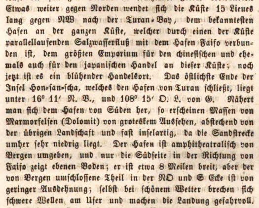
3689 International Journal of Science Academic Research, Vol. 03, Issue 04, pp.3688-3694, April, 2022
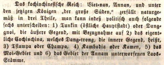
“Das kochinchinesische Reich [Empire of
Cochinchina/Vietnam]: Viet-nan, Annan [national name
Vietnam, Annam], and under the reigns of contemporary kings
“der grosze Süden” [national name Dai Nam]7, is naturally
divided into three parts, but politically one can also distinguish
the following six parts: 1) Tunkin8 (the eastern capital) or
Dang-gnoi [Dong Kinh or Tonkin, from north of the Gianh
River to out], the outer region, related to 2) the old
Cochinchina, called Dang-trong [In Dang Trong, from the
south of Song Gianh to KhanhHoa], the inner region, 3)
Tsiampa or Champa [Champa, Ninh Thuan region-
BinhThuan], 4) Cambodia or Kamen [Cambodia or Cambodia,
Excerpt from recognition of the fact that the Vietnamese king took possession
from Dong Nai to Ca Mau-Ha Tien], 5) Moi-Gebiet region
of the Paracel Islands in 1816 without international dispute, in a German book [Moi/Upper region, only Central Highlands] and 6) Laos-
published in Weimar in 1831: Crawfurd (John), Tagebuch der Gesandtschaft Stämme region [Lao tribes] submit to Annam”9.
an die Höfe von Siam und Cochin-China, AusdemEnglischen, Weimar:
ImVerlage des Großh.Sächs. priv. Landes-Industrie-Comptoirs, 1831, seite
712-713.
A rather famous publication of the Johann Georg Cotta Book
Publishing Company [J. G. Cotta'schen Buchhandlung] is the
journal Das Ausland [Overseas], published from 1828 to 1893
in the cities of Stuttgart, Munich, Augsburg and Tübingen, also
publishing geographical works translated from the country in
relation to Vietnam and the Paracel Islands. In the period
1828-1852, this magazine was titled: Das Ausland. Ein
Tagblattfür Kunde des geistigen und sittlichenLebens der Excerpt from a general description of the regions of the Cochin China
Völker, mitbesonderer Rücksicht auf verwandte Erscheinungen Empire/Vietnam in a German publication published in 1850: J. G. Cotta’schen
in Deutschland [Overseas. Daily newspaper on the intellectual Buchhandlung, Das Ausland. Ein Tagblattfür Kunde des geistigen und
and moral life of the peoples, with special attention to the sittlichen Lebens der Völker, mitbesonderer Rücksicht auf verwandte
Erscheinungen in Deutschland, Nr 90, 15 April 1850, Dreiundzwanzigster
phenomena related to Germany], a daily issue consisting of 4 Jahrgang - 1850, April, Stuttgart und Tübingen: Verlag der J. G. Cotta’schen
pages, numbered and consecutively numbered. At the end of Buchhandlung, 1850, seite 357.
the month, it is published in monthly volumes, and then
between the months until the end of the year, it is published in At No. 100, April 26, 1850, starting in the “Küsten und Inseln”
annual volumes. From 1853 to 1864, the magazine adjusted the [Coast and Islands] section of the study is the sea from
subtitles to: Das Ausland. Ein Wochenschriftfür Kunde des PhuQuoc island to Hon Khoai, with specific descriptions:
geistigen und sittlichen Lebens der Völker, mitbesonderer
Rücksicht auf verwandte Erscheinungen in Deutschland “If sailing along the very low-lying coast of Gosatran (Pursat
[Overseas. Weekly newspaper on the intellectual and moral in Cambodian) [present-day Pursat province in Cambodia,
life of the peoples, with special attention to phenomena related bordering Thailand] from the Siamese island of Kokong,
to Germany], published every week a 24-page issue, also where only mangroves marked the coast, the end With you,
numbered and consecutively for to the end of the month and you will come to the big island of Kothrol (Phukok [PhuQuoc]
then to the end of the year, and published in volumes month by in Cochinchinesen [In Cochinchina]), 7 meilen [miles long, 1
month and year by year as before. Since 1865, the journal meile = 1,609m] and 2 meilen wide, with dense trees,
continued to adjust the subtitles to: Das Ausland. Ueberschau especially agarwood trees. smell. Sea cucumber fishing is
der neuestenForschungen auf demGebiete der Natur-, Erd- und practiced along the coast, but the natives here, as elsewhere, do
Völkerkunde [Overseas. Survey of the latest research in the not wade into the sea to catch the animals with their hands, but
fields of nature, geography and ethnography]. Weekly issues use spears to stab them. This sea cucumber fishery extends to
and monthly and yearly volumes will continue. In Issues 90, 15 the important Nhieu-Kulao archipelago [Vietnamese
April 1850; 91, 16 April 1850; 100, 26 April 1850; 101, 27 pronunciation: many islands], these islands are overgrown but
April 1850 in April Volume, Year 23 - 1850, by Dr. Ed. uninhabited. In addition to sea cucumbers, several types of
Widenmann is in charge of editing, Das Ausland in turn seaweed (Agar-agar) [jellies] are collected here, which are
publishes a research paper titled "Geographie von Cochin- delicious Chinese dishes by boiling them to form jelly. The
China" [Geography of Cochinchina/Vietnam] by Dr. Güzlaff, coast here is still lower, extends to the west and is frequently
which is partially translated based on the publication. Author's flooded. 6 leguas [sea miles, 1 legua = 4,829m], before
publication in The Journal of the Royal Geographical Society reaching the southernmost tip of Cambodia [Cape Ca Mau], is
of London, Volume 19, London: John Murray, 1849. PuloUbi False [Banana Island], and 5 sea miles south of the
outcrop is Pulo Island Ubi, also known as Hon Kwae [Hon
Before referring to the Hoang Sa archipelago, at No. 90, April Khoai]. Both get the name Ubi from the huge 40 to 100 pfund
15, 1850, the research paper described the overall zoning of the yams [pounds, 1 pfund = 0.45359237 kg] that grow wild here;
territorial parts of the Vietnamese Empire under the Nguyen however, both islands have very different soils, as PuloUbi
Dynasty and the accompanying national titles for readers to False has dense forests, while PuloUbi has only sparse
read. easy to grasp as follows: vegetation”10.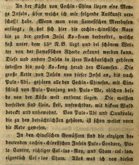
3690                         International Journal of Science Academic Research, Vol. 03, Issue 04, pp.3688-3694, April, 2022

                                                                               Excerpt describing the sea from Tho Chu island to Con Dao in a German
                                                                               publication published in 1850: J. G. Cotta’schenBuchhandlung, Das Ausland.
                                                                               Ein Tagblattfür Kunde des geistigen und sittlichen Lebens der Völker,
                                                                               mitbesondererRücksicht auf verwandte Erscheinungen in Deutschland, Nr
                                                                               100, 26 April 1850, Dreiundzwanzigster Jahrgang - 1850, April, Stuttgart und
                                                                               Tübingen: Verlag der J. G. Cotta’schen Buchhandlung, 1850, seite397.

                                                                               Regarding geographical features in the East Sea, the study
                                                                               describes the waters of the Paracel Islands with the Vietnamese
                                                                               name transliterated from Cat Vang, demonstrating Vietnam's
                                                                               recognition of the subject's role in these features. this
                                                                               geography. Not only that, the study also recognized that the
                                                                               Vietnamese Government took control there, maintaining the
                                                                               operation of the state-owned tax-collecting boats and having a
Excerpt describing the sea from Phu Quoc island to Hon Khoai in a German       crew to protect the fishing grounds and fishermen. of the
publication published in 1850: J. G. Cotta’schenBuchhandlung, Das Ausland.
Ein Tagblattfür Kunde des geistigen und sittlichen Lebens der Völker,
                                                                               country. The author wrote:
mitbesonderer Rücksicht auf verwandte Erscheinungen in Deutschland, Nr
100, 26 April 1850, Dreiundzwanzigster Jahrgang - 1850, April, Stuttgart und   “Much further to the northeast (15–20 leguas from the coast of
Tübingen: Verlag der J. G. Cotta’schen Buchhandlung, 1850, seite 397.          Annam [sea miles, 1 legua = 4,829m], between 13o and 17°
                                                                               north latitude) are Paracels (Katvang) [Hoang Sa] (Golden
Next is the description of the sea under Ca Mau cape, from
                                                                               Sand)], the archipelago, for unknown reasons, grew larger and
Tho Chu island to Con Dao, that:
                                                                               higher every year, so that some of the islands were
“Lying off the southern tip of Cambodia [Ca Mau Cape], about                   permanently inhabited, although a few years ago the waves
a degree north of PuloUbi, is PuloPanjang [Tho Chu/Tho Chau                    attacked them fiercely. The islands would be worth nothing if
island], surrounded by very small islands. It was inhabited only               fishing did not produce extraordinary yields, which is why so
occasionally when pirates from Sulu-Inseln [Sulu Islands in the                many sailing ships have long come here from Hainan; and
southwest of the Philippines] or Chinese ships came to collect                 although more than a tenth of them fail every year, the catches
the aforementioned seaweed. The cochinchinesische [Cochin                      are so plentiful that all losses are made up. The
China] government claimed to govern the archipelago, but did                   Cochinchinesische        Regierung       [Government           of
nothing to get rid of the pirates that roamed the archipelago                  Cochinchina/Vietnam] did not ignore this fact either, [claimed
and often sabotaged all trade along the Cambodian coast.                       possession since 1816] and maintained tax-collecting boats and
Further in the sea south of Pulo Panjang is the island of                      a small crew here to protect the fishermen. their. As a result, a
Konnon Kondore [Con Lon/Con Dao] whose high peaks were                         considerable amount of traffic has gradually formed here, as
used as landmarks for ships sailing to China. The island                       the numerous fish species that come here to spawn are likely to
produces a variety of plants and tree species that are rare in                 increase further”12.
other areas, such as the forest cashew [nutrition]. The island
that the Cochinchines held so dear was so well located that the
British established a colony here at the turn of the last century
[1702-1705] and built a fortress; however, it did not last long
because of the opposition of British-paid Buginesen
mercenaries envious of European trade, most of the British
were murdered and the settlement was left unfinished. To the
east of Con Dao jut out two rocky islands, which are
remarkable because they mark the westernmost extreme of
storms, so terrible over the chinesischen [China/East Sea]"11.

                                                                               Excerpt describing the waters of Hoang Sa-Cat Vang archipelago and the
                                                                               management and collection of taxes by the Vietnamese Government in a
                                                                               German publication published in 1850: J. G. Cotta’schen Buchhandlung, Das
                                                                               Ausland. Ein Tagblattfür Kunde des geistigen und sittlichenLebens der
                                                                               Völker, mitbesonderer Rücksicht auf verwandte Erscheinungen in
                                                                               Deutschland, Nr 100, 26 April 1850, Dreiundzwanzigster Jahrgang - 1850,
                                                                               April, Stuttgart und Tübingen: Verlag der J. G. Cotta’schen Buchhandlung,
                                                                               1850, seite 397.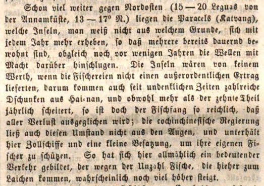
3691                         International Journal of Science Academic Research, Vol. 03, Issue 04, pp.3688-3694, April, 2022

Regarding the coastal waters adjacent to the Hoang Sa                          coast. The last coastal town in Cochinchina [Cochinchina] was
archipelago, which are Da Nang Bay and Hoi An port town,                       Kwan-Binh [QuangBinh]”14.
the study described in issues 101, 27-4-1850 as follows:

“A little further north, the coast turns northwest for 15 lieues
[sea miles, 1 lieu = 4,829m] to the Gulf of Turan [Da Nang],
the most famous port on the entire coast, which is connected
With Faifo [Hoi An] by a brackish river running parallel to the
coast [Co Co River], the largest port of the Chinese and
formerly a center of Japanese commerce on this coast, it is still
It was a prosperous commercial center. Hon-san-schaisland
[Son Tra Island], the estuary of Turan port, has coordinates
below 16° 11' north latitude and 108o 15' east longitude. If
approaching the harbor from the south, the marble massifs
(Dolomites) appear to have a peculiar appearance, contrasting
with the rest of the landscape and almost like an island, for the
sand around it is very short. The harbor is surrounded by                      Excerpts affirming that the Vietnamese state attaches great importance to
mountains, and only the south side in the direction of Faifo is                mapping the easternmost Paracel-Spratly seas in a German publication
flat; it is about 8 meilens [mile, 1 meile = 1,609m], but the                  published in 1850: J. G. Cotta’schen Buchhandlung, Das Ausland. Ein
                                                                               Tagblattfür Kunde des geistigen und sittlichen Lebens der Völker,
portion surrounded by mountains at the northeastern and                        mitbesonderer Rücksicht auf verwandte Erscheinungen in Deutschland, Nr
southern corners is very small; even when the weather is nice,                 101, 27 April 1850, Dreiundzwanzigster Jahrgang - 1850, April, Stuttgart und
big waves hit the shore, endangering the landing”13.                           Tübingen: Verlag der J. G. Cotta’schen Buchhandlung, 1850, seite 404.

                                                                               The German geographical publication recognized the
                                                                               Vietnamese king's legal possession of the Paracel Islands in
                                                                               1816

                                                                               Following the 1831 edition in Weimar city, which was
                                                                               translated from the English publication of John Crawfurd
                                                                               mentioned above, the works of German geographers also
                                                                               quickly voiced their recognition of the fact that the Hoang Sa
                                                                               archipelago was occupied by Vietnam. King of Vietnam in
                                                                               1816 as the new geographical knowledge of the world. The
                                                                               most significant of these is the series of works "Die Erdkunde"
                                                                               [Geography] consisting of many parts, volumes and volumes
                                                                               by the famous geographer Carl Ritter, published in the city of
                                                                               Berlin for a long time from 1817 until 1859. The fact that the
                                                                               Vietnamese king took possession of the Hoang Sa archipelago
                                                                               in 1816 has not been shown in the Asian part in the series of
                                                                               works "Die Erdkunde" by Carl Ritter in the first edition since
                                                                               181715; but in reprints from 1832 onwards, Carl Ritter actively
                                                                               increased the number of additions and revisions in many
Excerpt describing Da Nang Bay adjacent to the waters of the Paracel Islands
in a German publication published in 1850: J. G. Cotta’schen Buchhandlung,
                                                                               places, including that content. In the 1834 reprint, the title of
Das Ausland. Ein Tagblattfür Kunde des geistigen und sittlichen Lebens der     the first cover read: Die Erdkunde von Asien- Band III. Der
Völker, mitbesonderer Rücksicht auf verwandte Erscheinungen in                 Süd-Osten von Hoch-Asien, dessen Wassersysteme und
Deutschland, Nr 101, 27 April 1850, Dreiundzwanzigster Jahrgang - 1850,        Gliederungengegen Osten und Süden [Geography of Asia-
April, Stuttgart und Tübingen: Verlag der J. G. Cotta’schen Buchhandlung,
1850, seite 404.
                                                                               Volume III. Mainland Southeast Asia, its water systems and
                                                                               structures in the east and south]; and the title on the second
In particular, when continuing to describe the waters of                       cover is: Die Erdkundeim Verhältnißzur Natur und zur
Tonkin, the author has made very unique comparisons to                         Geschichte des Menschen, oderallgemeinevergleichende
affirm that the Vietnamese state attaches great importance to                  Geographie, alssichere Grundlage des Studiums und
the survey and mapping of the Paracels-Spratlys in the South                   Unterrichts in physikalischen und historischen Wissenschilten,
China Sea. Winter. The author wrote:                                           Zweites Theuchilschaften. Asien, Band III [Geography in
                                                                               relation to nature and human history, or, General comparative
“The portion of the coast described so far has been accurately                 geography, as a safe basis for the study and teaching of the
documented, but reports of its further condition are scant, so                 natural and historical sciences- Part fourth, Second volume.
much of Tunkin Bay [Tien Ngoai] is still considered a coastal                  Asia, Volume III]16.
area. The sea is not well known. This is all the more
astonishing, as the neighboring seas are all more carefully                    In the contents of Volume III, reprinted 1834, at
explored, and the annamesische Regierung [Government of                        “ZweiteAbtheilung: Die Uebergangsformen des östlichen
Annam] spared no expense and effort to draw accurate maps of                   Hoch-Asienszum Tieflande, oderdessen Wassersysteme und
the poles. east [map of Hoang Sa-Spratly under Minh Mang                       Stufenländer, imOsten und Süden” [Second Part: Transitional
Dynasty]. This oblivion was certainly the result of a desire to                Forms from Continent” East Asia to the lowlands, or the water
bury Tunkin in oblivion to protect it from European scrutiny.                  system and its terraces to the east and south]; in
Therefore, we have very little to say about the last part of the               “ZweiterAbschnitt: Die Uebergangsformen des östlichen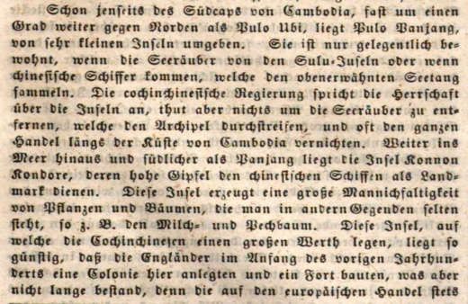
3692 International Journal of Science Academic Research, Vol. 03, Issue 04, pp.3688-3694, April, 2022
Hoch-Asienszum Tieflande, oderdessen Wassersysteme, Cochinchina/Vietnam], since 1816, to be his possession.
Stufenländer und Gliederungenzum Süden in Hinter-Indien” without any objections from neighboring countries; they are
[Second entry: Transitional forms from mainland East Asia to not coastal islands, but in the middle of a vast ocean.”19.
the lowlands, or water its system, steps and structures south of
India]; in “$. 84. ErstesKapitel: Das Ostgestadeland Hinter-
Indiens, Tongking, Cochin China, Cambodja. Uebersicht des
gegenwärtigen Cochin ChinesischenReiches” [$. 84. Chapter
One: The country across the East Indies, Tonkin, Cochin
China, Cambodia. Overview of the current Cochin
China/Vietnam Empire], from page 911 to page 1063; in
subsection “4. Die Gestade - Inseln” [4. Coast - Islands], the
book describes in detail the coast of Cochinchine/Vietnam with
islands near the shore and mentions the event that the
Vietnamese king/Gia Long claimed possession of the Hoang
Sa archipelago in the ocean in 1816 without There are
international disputes as follows:
“This coastal area has many islands, but only the small coastal
islands to the northeast of Hainan big island have changed. It
appears that the depths of the Sunda Sea, apparently from
points south of Malacca, Sumatra and Java, in the mighty
island belt around the Chinesische See [Chinese sea/South
China Sea] to Manillas, Luçon [in the Philippines], Formosa
[…] Taiwan], at a greater distance from the coast, crosses the
most islands; The energy on the islands has been exhausted to
push many insignificant pieces of old cliffs off this stretch of
coast in the South China Sea, close to the mainland. They only
come near the coastal edge.
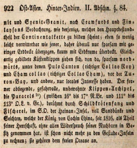
Excerpts describing the coast of Cochinchina and recognizing the Vietnamese
Some islands located at the innermost corner of the Gulf of king's possession of the Paracel Islands in 1816 without international dispute,
Siam, such as KoKran Island (below 13° North latitude), are in a German publication republished in 1834:
still inhabited by the Cochin Chinese Ritter (Carl),Die Erdkunde von Asien- Band III. Der Süd-Osten von Hoch-
[Cochinchine/Vietnamese] settlers, but belong to Siam like Asien, dessen Wassersysteme und Gliederungengegen Osten und Süden (Die
other islands southeast of Ko Kong (see above, page 912)17. Erdkundeim Verhältnißzur Natur und zur Geschichte des Menschen,
Larger island groups from there run to the southeast of oderallgemeinevergleichende Geographie, alssichere Grundlage des
Studiums und Unterrichts in physikalischen und historischen
PuloUbi [HònKhoai] opposite Kambodja-Spitze [Cape of Wissenschaften- VierterTheil, Zweites Buch. Asien, Band III), Zweite stark
Cambodia/ Cape Ca Mau], where it is named Hastings- vermehrte und umgearbeitete Ausgabe, Berlin: Gedruckt und verlegtbei Georg
Archipelagus [Ha Tien Archipelago], including the islands of Reimer, 1834, seite 921-922.
PuloPanjang [Tho Chau island/Tho Chu] and Pulo We [in the
Gulf of Siam], located in waters wholly belonging to Cochin The encyclopedia of Germany recognized the Vietnamese
China [Cochin China]. Most of the islands are small, steep, king's legal possession of the Paracel Islands in 1816
deserted, densely wooded, and uninhabited. The island of
PuloCondore [Con Lon/Con Dao] is very interesting, where The recognition of the official occupation of the Paracel
there are dozens of smaller cliffs, the mountainous nature of Islands by the Vietnamese state in 1816 was also included in
Cochin Chinas [Dang Trong/Vietnam] also begins with the the massive German encyclopedia entitled: Encyklopädie der
island formation process; as it is the first steep island with high Erd-, Völker- und Staatenkunde. Encyclopedia of the Earth,
mountains of primary rock and favorable harbor formation, People and State Institutions], edited by Dr. Wilhelm
which characterizes the entire steep coastline of Cochin Hoffmann, published in Leipzig between 1862 and 1869,
Chinesische [Cochin China]; and as observed by Crawfurd and divided into 3 volumes:
Finlayson18, the mountain type of the island is gray granite
and syenite-granite [a coarse-grained intrusive magmatic rock Volume I: "A" to "I", published in 1862.
with a composition close to that of granite], as that seems to Volume II: from “K” to “Radruz”, published in 1866.
form the main component of the rock. continental chain; they Volume III: from “Radsberg” to “Z”, published in 1869.
are less weathered, so there is only a thin layer of soil spread
everywhere, almost no soil layer is covered. The coastal cliffs In Volume I: Hoffmann (Wilhelm), Encyklopädie der Erd-,
were formed in a similar fashion, shifting from there to the Völker- und Staatenkunde, einegeographisch-statistische
north, including Pulo Canton (or rather Col lao Roy) [Ly Son Darstellung de Erdtheile, Länder, Meere, Inseln, Gebirge,
island, or Cu Lao Ray/Ré] and Cham col lao (or rather Col lao Berge, Vorgebirge, Buchten, Häfen, Flüsse, Seen, , Städte,
Cham) [Cu Lao Cham], in front of Turon Bay [Da Nang], and Flecken, Dörfer, Bäder, Berg- und Hüttenwerke Leuchtthürme,
other places that are purely local. The remote, dangerous, Kanäle, Eisenbahnen, usw, nebst den geographisch-
uninhabited cliff archipelago is the Paracels [Paracel Islands] astronomichen Bestimmungen der Lage der Orte
(between 16° and 17° North latitude and 111° to 113° East [Encyclopedia of the Earth, Peoples and State Institutions,
longitude), famous for turtle fishing. and fish, located description, description statistics-geography of parts of the
southeast of Hainan Island, consisting of small sandy islets and earth, countries, seas, islands, mountain ranges, mountains,
shoals claimed by König von Cochin China [king of outcrops, bays, ports, rivers, lakes, peoples, states, cities,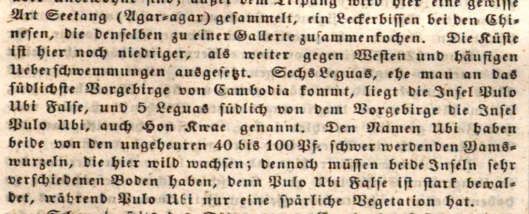
3693                    International Journal of Science Academic Research, Vol. 03, Issue 04, pp.3688-3694, April, 2022

places, villages, mineral springs, iron mines, lighthouses,
canals, railways, etc., together with the geo-astronomical
positions of the sites], Erster Band, A bis I, Leipzig:
ArnoldischeBuchhandlung, 1862, entry: “An-nam, Ai-Nam,
En-Nam” [An Nam/Vietnam], from page 87 to page 88,
overview of the coast and islands of the empire and the
possession of the Paracel Islands by the Vietnamese king Male
in 1816 was c he received the following:

“On the coast there are many different large and small islands;
In particular, the southwestern coast of the Gulf of Siam has a
dense island chain stretching along the coast of Siam (see
Horsburgh's charts) 20. The largest island is Koh-Dud or Fuh-
Koh [PhuQuoc] (10o 40' North latitude, 103o 13' East
longitude). It is located at the northernmost point of Hastings
Islands [Ha Tien], and the southernmost point is Cape
Cambodja [Cambodia, ie Cape Ca Mau], Pulo-Obi [Hon
Khoai] in the southeast-southeast direction from the south of
PhuQuoc Island ; the coast has Poulo-Babi island [Hon Tai?];
The southwest corner includes a group of seven small islands,
Hong-co-Throng [Cu Tron/Cò Tre, presumably Nam Du                          Excerpts describing the coast of Annam and recognizing the Vietnamese king's
                                                                           possession of the Paracel Islands in 1816 in the German encyclopedia
archipelago], to the southeast of Koh-Kong [in the Gulf of                 1862:Hoffmann (Wilhelm), Encyklopädie der Erd-, Völker- und
Siam, now part of Cambodia] ]; the west-southwest corner is                Staatenkunde, Erster Band, A bis I, Leipzig: ArnoldischeBuchhandlung, 1862,
Poulo-Panjang [Tho Chau island/Tho Chu, now part of                        seite 87.
KienGiang]; southeast is False-Oby [Banana Island]; south-
southeast is Puolo-Oby [Hon Khoai]. Facing the southeast                   Conclusion
coast is Pulo-Condore [Con Lon/Con Dao] with several
surrounding small islands. The island consists of gray granite             There are quite a few publications published in countries
and syenite-granite [coarse-grained intrusive magmatic rock                around the world before 1909 mentioning and recognizing the
with a composition close to that of granite] forming a high                official possession of the Hoang Sa and Truong Sa
sloping mountain range, but with a fine harbor. The northeast              archipelagoes by the Vietnamese state since 1816, including
direction between less than 10o North latitude and 108o 58'                Germany, which we have controlled. we are talking about.
East longitude is Pulo-Sapota island [Hon Hai/Hon Kham,                    From the publications published in Germany before the 20th
65km south of PhuQuy island in BinhThuan]; to the northwest                century cited above, it can be affirmed that they are objective
is Catwick Island [Large Island and Small Island, 60 km                    international historical data affirming Vietnam's indisputable
southeast and south of PhuQuy Island]; To the north is Ceicer              sovereignty over the two Hoang Sa and Truong Sa, meeting
de Mer [PhuQuy Island, or Cu Lao Thu in BinhThuan], and                    the search, gathering and use needs of a large number of world
closer to the coast is Ceicer de Terre [Cu Lao Cau/Cau in                  marine and island researchers.
BinhThuan], in the middle of the Legan cape [Long Son] /Mui
Ne] and Padaran [MuiDinh/Mui Ca Na, 40 km south of Phan                    Note
Rang]; to the north near the coast is Bamboo Island [Hon Tre,
in KhanhHoa]; N. vom Cap Varela; near the northern coast of                1. The author has invested a lot of effort to complete the
Cape Varela [Mui Dai Lanh/MuiDien/Mui Nay/Mui Kite in                         research paper.
Phu Yen] is the island of Pulo-Cambir [Green Isle, in                      2. John Crawfurd, originally from Scotland, was sent by
BinhDinh]; continuing to the north are the islands of Turtle,                 Governor General Hastings of Great Britain in India as an
Collao-Eiland (15o 12' North latitude, 108o 58' East longitude)               ambassador from Singapore to Siam and Vietnam. During
[Cu Lao Re/Ray, ie Ly Son island in Quang Ngai]; to the                       nearly two and a half months in Vietnam [17.8 -
northwest is False-Callao, Cham-Callao [Cu Lao Cham, in                       31.10.1822], Crawfurd had the opportunity to visit Ca Mau,
Quang Nam]. Off the east coast of the China Sea [Chinese                      Hon Khoai, PhuQuoc, Con Dao, Can Gio, Saigon, Da
Sea/East Sea] is a group of dangerous uninhabited cliffs named                Nang, Hue, Da Nang and Hoi. An, Da Nang for field
Paracel-Inseln [Paracel Islands] (from 15o 45' to 17o north                   survey for many days. More details about John Crawfurd
latitude and 111o 13' to 112o 43' East longitude), possessed                  can be found at: Nguyen QuangTrung Tien, "Appraisal of
since 1816 by Könige von Cochin-China [King of Cochin                         the first international edition to recognize the unified state
China] and quite effective for catching turtles and fish. The                 of Vietnam under King Gia Long's official possession of
most remote part of this archipelago to the southwest is Triton               the Paracel-Spratly Islands in 1816", Da Nang Socio-
Island [Tri Ton]; to the northeast is the island of Passo-Keak                Economic Development, ISSN 1859-3437, No. 145,
[Bach Quy]; north-northwest is the island group of Drummond                   01.2022, p. 40-49.
[DuyMong]; to the west is Money Island [Light]; the                        3. 3Crawfurd (John), Journal of an Embassy from the
easternmost is Lincoln Island [Linh Con]; Woody Island [Phu                   Governor-General of India to the Courts of Siam and
Lam] is located in the northwest; north-northwest and the                     Cochin China; exhibiting a view of the actual state of those
northernmost is the Amphitrite group of islands [An Vinh                      kingdoms, (London: Henry Colburn, New Burlington
group of islands]. Next, near the east-northeast coast is Cape                Street, 1828).
Lay, Tiger Island; to the northwest are the islands of Sovel,              4. Before 1834, the nouns Cochin-China, Cochin-Chinesen,
Frakaki…etc. [coastal islands in the Gulf of Tonkin]21.                       kochinchinesische cited in this article were used
                                                                              internationally in the old sense as the land of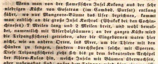
3694                      International Journal of Science Academic Research, Vol. 03, Issue 04, pp.3688-3694, April, 2022

    Cochinchina/Nam Ha. In many specific contexts, it is also               12. 15Ritter (Carl), Die ErdkundeimVerhältnißzurNatur und zur
    used by European and American countries as a synonym                        Geschichte des Menschen, oderallgemeine, vergleichende
    for the Annam empire or Vietnam [the national title of                      Geographie, alssichere Grundlage des Studiums und
    King Gia Long and Minh Mang in the period 1804-1838].                       Unterrichts      in   physikalischen    und    historischen
    Since 1834, when King Minh Mang divided the                                 Wissenschaften, Erster Theil, (Berlin:Bei G. Reimer, 1817).
    administrative area of Cochinchina from Bien Hoa                        13. 16Ritter (Carl), Die Erdkunde von Asien- Band III. Der Süd-
    province back, this name still refers to the land of Dang                   Osten von Hoch-Asien, dessen Wassersysteme und
    Trong. After the two treaties of Harmand and Patenôtre in                   Gliederungengegen Osten und Süden (Die Erdkundeim
    1883 and 1884, that name changed completely to the                          Verhältnißzur Natur und zur Geschichte des Menschen,
    meaning of Cochinchina, but in some contexts it can still                   oderallgemeinevergleichende       Geographie,    alssichere
    be used in the sense of Cochinchina.                                        Grundlage des Studiums und Unterrichts in physikalischen
5. 5 In the text, the words in parentheses (…) are from the                     und historischen Wissenschaften, Vierter Theil, Zweites
    original cited text; and the words in brackets [...] are ours to            Buch. Asien, Band III), Zweite stark vermehrte und
    use for direct explanation to help readers follow along. In                 umgearbeitete Ausgabe, (Berlin: Gedruckt und verlegtbei
    cases where longer explanations or illustrations are                        Georg Reimer, 1834).
    required, we number the footnotes.                                      14. Footnotes in parentheses are from Carl Ritter in the
6. 6 Crawfurd (John), Tagebuch der Gesandtschaftan die Höfe                     original.
    von Siam und Cochin-China, Ausdem Englischen,                           15. Explorers and geographers with published work.
    (Weimar: Im Verlage des Großh.Sächs. priv. Landes-                      16. Ritter (Carl), Die Erdkunde von Asien- Band III (op. cit.,
    Industrie-Comptoirs, 1831), 712-713.                                        1834), 921-922.
7. 7. The national name of Kings Gia Long and Minh Mang in                  17. Footnotes in parentheses are from Wilhelm Hoffmann in
    the period 1804-1838 was Vietnam, from 1838 King Minh                       the original.
    Mang changed it to Dai Nam.                                             18. Hoffmann (Wilhelm), Encyklopädie der Erd-, Völker- und
8. 8. Before 1834, the noun Tunkin cited in this article also                   Staatenkunde, Erster Band, A bis I, (Leipzig: Arnoldische
    had the old meaning of the land of Dang Ngoai/Bac Ha.                       Buchhandlung, 1862), 87.
    Only after 1834, when King Minh Mang of the Nguyen
    Dynasty divided the administrative area of Tonkin from                  REFERENCES
    NinhBinh province onwards, did that name begin to
    associate with the meaning of Tonkin, but there are still               Crawfurd (John). 1831. Tagebuch der Gesandtschaftan die
    many documents that continue to be used according to the                    Höfe von Siam und Cochin-China. Ausdem Englischen.
    meaning of Tonkin. the meaning of Tonkin, depending on                      Weimar: ImVerlage des Großh. Sächs. priv. Landes-
    the context.                                                                Industrie-Comptoirs.
9. 9 J. G. Cotta’schen Buchhandlung, Das Ausland.                           Hoffmann (Wilhelm). 1862. Encyklopädie der Erd-, Völker-
    EinTagblattfürKunde des geistigen und sittlichenLebens                      und Staatenkunde. Erster Band, A bis I. Leipzig:
    der Völker, mitbesonderer Rücksicht auf verwandte                           Arnoldische Buchhandlung.
    Erscheinungen in Deutschland, Nr 90, 15 April 1850,                     Cotta'schen Buchhandlung, J. G. 1850. Das Ausland.
    Dreiundzwanzigster Jahrgang - 1850, April, (Stuttgart und                   EinTagblattfürKunde des geistigen und sittlichenLebens
    Tübingen: Verlag der J. G. Cotta’schen Buchhandlung,                        der Völker, mitbesondererRücksicht auf verwandte
    1850), 357.                                                                 Erscheinungen in Deutschland. Dreiundzwanzigster
10. 10, 11, 12 J. G. Cotta’schen Buchhandlung, Das Ausland.                     Jahrgang - 1850. April. Stuttgart und Tübingen: Verlag der
    EinTagblattfürKunde des geistigen und sittlichen Lebens                     J. G. Cotta'schenBuchhandlung.
    der Völker, mitbesonderer Rücksicht auf verwandte                       Ritter (Carl). 1817. Die ErdkundeimVerhältnißzurNatur und
    Erscheinungen in Deutschland, Nr 100, 26 April 1850,                        zur     Geschichte   des     Menschen,     oderallgemeine,
    Dreiundzwanzigster Jahrgang - 1850, April, (Stuttgart und                   vergleichende Geographie, alssichere Grundlage des
    Tübingen: Verlag der J. G. Cotta’schen Buchhandlung,                        Studiums und Unterrichts in physikalischen und
    1850), 397.                                                                 historischen Wissenschaften. ErsterTheil. Berlin: Bei G.
11. 13, 14 J. G. Cotta’schen Buchhandlung, Das Ausland.                         Reimer.
    EinTagblattfürKunde des geistigen und sittlichen Lebens                 Ritter (Carl), 1834. Die Erdkunde von Asien- Band III. Der
    der Völker, mitbesonderer Rücksicht auf verwandte                           Süd-Osten von Hoch-Asien, dessen Wassersysteme und
    Erscheinungen in Deutschland, Nr 101, 27 April 1850,                        GliederungengegenOsten und Süden, Zweites Buch, Asien,
    Dreiundzwanzigster Jahrgang - 1850, April, (Stuttgart und                   Band III). Zweite stark vermehrte und umgearbeitete
    Tübingen: Verlag der J. G. Cotta’schen Buchhandlung,                        Ausgabe. Berlin: Gedruckt und verlegtbei Georg Reimer.
    1850), 404.

                                                                    *******
You can also read