Ocean Bottom Electromagnetometer Carried From Bonin to Ryukyu Islands by Sea Currents
←
→
Page content transcription
If your browser does not render page correctly, please read the page content below
Ocean Bottom Electromagnetometer Carried From Bonin to Ryukyu Islands by Sea Currents Noriko Tada ( norikot@jamstec.go.jp ) Japan Agency for Marine-Earth Science and Technology: Kaiyo Kenkyu Kaihatsu Kiko https://orcid.org/0000-0002-0555-1843 Haruka Nishikawa Japan Agency for Marine-Earth Science and Technology: Kaiyo Kenkyu Kaihatsu Kiko Hiroshi Ichihara Nagoya University: Nagoya Daigaku Hiromi Kayama Watanabe Japan Agency for Marine-Earth Science and Technology: Kaiyo Kenkyu Kaihatsu Kiko Tatsu Kuwatani Japan Agency for Marine-Earth Science and Technology: Kaiyo Kenkyu Kaihatsu Kiko Express Letter Keywords: Ocean bottom electromagnetometer (OBEM), Nishinoshima volcano, Iriomote Island, Drifting simulation, Pumice, Fukutoku-Oka-no-Ba Posted Date: October 19th, 2021 DOI: https://doi.org/10.21203/rs.3.rs-966838/v1 License: This work is licensed under a Creative Commons Attribution 4.0 International License. Read Full License
Title page:

Title: Ocean bottom electromagnetometer carried from Bonin to Ryukyu Islands

by sea currents

Author #1: Noriko Tada, Research Institute for Marine Geodynamics (IMG), Japan

Agency for Marine-Earth Science and Technology, 2-15 Natsushima-cho, Yokosuka,

Kanagawa 237-0061, Japan, norikot@jamstec.go.jp

Author #2: Haruka Nishikawa, Research Institute for Value-Added-Information

Generation (VAiG), Japan Agency for Marine-Earth Science and Technology, 2-15

Natsushima-cho, Yokosuka, Kanagawa 237-0061, Japan, harukan@jamstec.go.jp

Author #3: Hiroshi Ichihara, Earthquake and Volcano Research Center, Graduate

School of Environmental Studies, Nagoya University, Furo‑cho, Chikusa‑ku, Nagoya,

Aichi 464‑8601, Japan, h-ichi@seis.nagoya-u.ac.jp; Research Institute for Marine

Geodynamics (IMG), Japan Agency for Marine-Earth Science and Technology, 2-15

Natsushima-cho, Yokosuka, Kanagawa 237-0061, Japan

Author #4: Hiromi Kayama Watanabe, Institute for Extra-cutting-edge Science and

Technology Avant-garde Research (X-star), Japan Agency for Marine-Earth Science

and Technology, 2-15 Natsushima-cho, Yokosuka, Kanagawa 237-0061, Japan,

hwatanabe@jamstec.go.jp

Author #5: Tatsu Kuwatani, Research Institute for Marine Geodynamics (IMG), Japan

Agency for Marine-Earth Science and Technology, 2-15 Natsushima-cho, Yokosuka,

Kanagawa 237-0061, Japan, kuwatani@jamstec.go.jp

                                                                                    1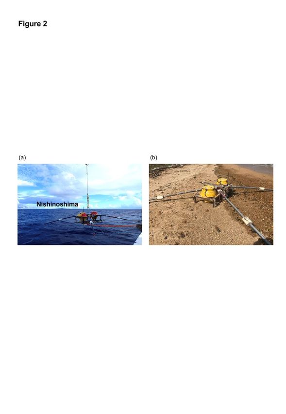
Indicate the corresponding author

Noriko Tada

Please refer to the submission guidelines for details.

https://earth-planets-space.springeropen.com/submission-guidelines/preparing-your-manuscript

(go to new page)

                                                                                               2
Abstract
Ocean bottom electromagnetometers (OBEMs) installed on the seafloor around
Nishinoshima Island (Bonin Islands) were missing after a December volcanic eruption.
In February 2021, one was found on a beach on Iriomote Island (Ryukyu Islands),
implying that it drifted westward for 1,700 km. The reason(s) for the disappearance of
the OBEMs and the path followed by the recovered OBEM while drifting are important
information for future ocean bottom observations and seafloor volcanology in general.
We conducted particle drifting simulations with and without horizonal eddy diffusion to
estimate the possible drift path and duration of the recovered OBEM. Our simulations
show that particles transported from Nishinoshima have a 7-10 % probability of arriving
at Iriomote Island, which is thus not a rare occurrence. Transport durations in our
simulations varied widely between 140 and 602 days depending on the drift paths. The
most likely drift duration in our simulation was 150 – 180 days, with or without eddy
diffusion, corresponding to the release from the seafloor of the OBEM between 22 August
and 21 September 2020. These dates follow shortly after intensifying eruptions at
Nishinoshima, which may have affected the seafloor around the island. A similar drift
duration and path was reported for pumices that erupted from Fukutoku-Oka-no-Ba
submarine volcano (northern Bonin Islands) during 18-21 January 1986 and arrived in
the Ryukyu Islands in late May 1986. Such drifting simulations may prove useful for
identifying the sources of drift pumices, and thus otherwise undetectable eruptions.
Finally, the Fukutoku-Oka-no-Ba submarine volcano erupted on 13 August 2021,
producing abundant pumice rafts that, based on our results, will likely arrive in the
Ryukyu Islands in the coming months.
3Keywords
Ocean bottom electromagnetometer (OBEM)
Nishinoshima volcano
Iriomote Island
Drifting simulation
Pumice
Fukutoku-Oka-no-Ba
Main Text
1. Introduction
Seafloor observations are essential to Earth sciences because oceans cover about 70%
of the Earth’s surface and most major earthquakes and other geological events occur
beneath the seafloor. Seafloor observation equipment often encounters unexpected
trouble in deep-water locations; some instruments are lost during recovery whereas others
disappear suddenly during their observational period. In the latter case, it is difficult to
find and retrieve them, and precious scientific data and the instruments can be lost.
Although such cases are not generally reported in scientific or official literature, they are
known to occur during submarine volcanic eruptions and/or earthquakes, most likely
while the instruments are recording indispensable data. For instance, ocean bottom
seismometers recording at the time of the 2011 Tohoku-Oki earthquake (Mw 9.0) could
not be retrieved because they were either entrained in earthquake-generated turbidites
(e.g., Japan Agency for Marine-Earth Science and Technology 2011, 2012) or dislodged
from their installation locations. Some of those seismometers were retrieved during a
special operation using a remotely operated vehicle and were found to have recorded the
4passing of the tsunami while trapped in the turbidites (Arai et al. 2013). Hence, it is
essential to retrieve lost instruments, and thus to investigate the reason(s) for their loss
and the paths and durations of their drifting at the sea surface.
The Izu-Bonin (Ogasawara) Arc is one of the most active volcanic areas in the world
(e.g., Tamura et al. 2016). For instance, Nishinoshima, an uninhabited volcanic island in
the Bonin archipelago (~1,000 km south of Tokyo, Japan; Fig. 1), has intermittently
erupted since November 2013 (e.g., Maeno et al. 2016; Kaneko et al. 2019). Most recently,
a caldera-forming eruption occurred at Fukutoku-Oka-no-Ba, a submarine volcano about
250 km south of Nishinoshima (~5 km northeast of Minami Iwo Island; Figure 1), on 13
August 2021 (Japan Meteorological Agency 2021). These volcanos offer an exceptional
opportunity to study ongoing island-forming eruptive processes and the structures of
active submarine volcanoes.
It is difficult to study such submarine volcanoes because we generally do not know
their precise eruption histories. A few literature reports attributed pumices found on the
coasts of Ryukyu, Kyushu, and Shikoku Islands to eruptions in the Bonin Islands (e.g.,
Kato 1988; Nakano and Kawabe 1992). These pumices might have drifted from east to
west along unimaginable routes. Determining the origin of such pumices and their drift
times and paths might reveal previously unknown volcanic eruptions.
Ocean bottom electromagnetometers (OBEMs) measure seafloor magnetic and
electric fields variations, and are the only available means of estimating the detailed
electrical conductivity structure beneath the seafloor. Because electrical conductivity is
sensitive to temperature and presence of volatiles and aqueous pore fluids, OBEMs
provide invaluable information on the thermal, hydrological and mineralogical structure
beneath the seafloor (e.g., Tada et al. 2016; Naif et al. 2013). We installed OBEMs on the
seafloor around Nishinoshima to estimate the electrical conductivity structure of the
volcanic body and identify the location and dimensions of the magma chamber. However,
some OBEMs were missing after a volcanic eruption in December 2019. Surprisingly, in
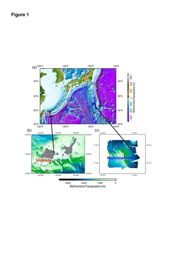
February 2021, one was found on Takana beach on Iriomote Island, about 1,700 km west
of Nishinoshima (Figs. 1, 2). We retrieved this OBEM in perfect condition and recovered
the data recorded at Nishinoshima. The recovery of this OBEM on Iriomote Island
demonstrates that materials can drift from the Bonin to the Ryukyu Islands.
Determining the reason(s) for the disappearance of OBEMs and their subsequent
5drifting routes and durations is important for ocean bottom observations and seafloor
volcanology in general because this information can be used to (1) find and recover future
missing instruments and (2) constrain the origins or forecast the routes of drifting pumices.
Here, we report on the installation, loss, and subsequent recovery on Iriomote Island
of an OBEM installed at Nishinoshima. We also performed simulations to estimate its
drift path and duration. Based on our simulations, we relate the OBEM’s disappearance
to volcanic activity at Nishinoshima and discuss implications for drifting pumices.
2. Installation, loss, and recovery of the OBEM
OBEMs are generally installed for a few months to a few years depending on the
objective of the project and power limitations. In the OBEM devices used in our studies,
most of the instruments are contained within two 17-inch glass spheres under vacuum,
each covered by a plastic sphere; one sphere contains a fluxgate magnetometer, two
tiltmeters, a thermometer, and a data logger, and the other contains batteries and a
transducer circuit. Each device has four orthogonally attached pipe arms containing five
Ag-AgCl electrodes and is supported by an aluminum frame containing an acoustic
transponder, a radio beacon, a xenon flasher, and an anchoring weight (Figure 2a; e.g.,
Seama et al. 2007). Our OBEMs measure time series of magnetic field (three
components), electric field (two components), and instrument tilt.
During their installation, OBEMs are dropped off a ship, free-fall to the sea surface,
and settle to the seafloor under their own weight. Because OBEMs encounter water
currents while settling, their final installed positions differ from their launch positions.
Once on the seafloor, OBEMs typically couple with seafloor sediments and remain
stationary. Thus, their installed positions are generally calibrated in three dimensions only
once (at the time of installation) by sounding with the acoustic transponder on the OBEM
and a shipboard transducer. On completion of the project, a release command triggers an
electrical current through the thin metal wire connecting the OBEM to its anchor, and the
OBEM floats to the sea surface for recovery.
We initiated OBEM observations around Nishinoshima in 2016 to estimate the
electrical conductivity structure of the island (Baba et al., 2020). In September 2018, we
deployed six more OBEMs around Nishinoshima from the Japan Meteorological Agency
6(JMA) weather ship Keifu Maru (cruise KS18-07). After verifying that each OBEM had
settled to the seafloor, their positions were determined by sounding.
About nine months later, in June 2019, we attempted to retrieve the six OBEMs during
cruise KS19-05 of the Keifu Maru. In this particular operation, we recalibrated the
positions of the OBEMs because it was known that some of them had moved, perhaps
due to volcanic activity and/or slope collapse (Baba et al., 2020). We recovered four
OBEMs but were unable to recover the other two (JM4 and JM6) during that cruise.
JM4 was deployed on 10 September 2018 on the eastern flank of Nishinoshima
(observation site NS15, 27°16.1222’N, 140°59.5671’E, ~2,033 m water depth). Upon
recalibration on 10 June 2019, the position of JM4 was 27°16.1303’N, 140°59.5779’E
(Figure 1c), about 23.3 m downslope to the N49.8°E from its installation position. After
recalibrating its position, we sent the release command and the transponder responded
normally. However, after more than 28 h, JM4 had not surfaced; we inferred that it was
trapped on the seafloor by overlying sediments, as was the case for the OBEM that was
buried in thick mud during the 2011 Tohoku-Oki earthquake (Japan Agency for Marine-
Earth Science and Technology 2012).
JM6 was also deployed on 10 September 2018, but on the southern flank of
Nishinoshima, between the main edifice and submarine volcano. Its initial installation
position was 27°11.7955’N, 140°52.4258’E at about 991 m depth. Upon recalibration on
8 June 2019, its position was 27°11.8011’N, 140°52.3908’E at about 989 m depth, 58.6
m to the N79.8°W from its initial position. As with JM4, JM6 did not surface even though
it responded normally to the release command.
We later tried to recover JM4 and JM6 using the remotely operated vehicle (ROV)
KM-ROV on 13 and 14 December 2020 during cruise KM20-11 of the Japan Agency for
Marine-Earth Science and Technology (JAMSTEC) ship R/V Kaimei. Before deploying
KM-ROV, we called the transponders of JM4 and JM6 using the ship’s transducer, but
did not receive any signal. We searched the seafloor for JM4 and JM6 around their last
known positions using the sonar and video cameras on KM-ROV; after about two hours
of searching for each, we called off the search.
One of the authors (H. Ichihara) received an email on 19 February 2021 from the
Iriomote Ecotourism Association (Iriomote Island, Okinawa prefecture) reporting that an
OBEM had drifted ashore there. The OBEM (Fig. 2b) was discovered on a beach on the
7northeast part of the island (Fig. 1b) during beach cleaning on 18 February. We visited
the island to retrieve the OBEM on 11 March 2021 and found it to be JM4.
Its surface was fully covered with lugworms (serpulid polychaetes), and several stalked
barnacles of the genus Lepas were attached to it. The capitular lengths of L. anserifera
exceeded 10 mm, suggesting that the barnacles had been attached to the OBEM for more
than 50 days before its retrieval (Inatsuchi et al. 2010). Upon inspecting the glass spheres,
we found that the vacuum had been maintained until we opened them. Therefore, JM4
maintained its buoyancy after releasing its anchor, and it must have drifted on the sea
surface from around Nishinoshima to Iriomote Island. Time-series data were recorded
until late August 2019, when the batteries were most likely exhausted. The data logs
contained no direct information related to the release of its weight or JM4’s ascent to the
sea surface.
3. Drifting simulations
We conducted drifting simulations to estimate the possible route and duration of JM4’s
travel from Nishinoshima to the Iriomote Island. We used horizontal velocities, sea-
surface temperatures, and salinities from the ocean reanalysis dataset of the JMA’s
operational numerical weather prediction model (Japan Meteorological Agency 2013).
This daily dataset has 0.1º × 0.1º horizontal resolution.
We set particles around Iriomote Island and conducted backward particle tracking
experiments because the timing of JM4’s stranding on Iriomote Island is much better
constrained than that of its departure from Nishinoshima. We released particles at 1 m
depth in the simulations because JM4 never lost is buoyancy and sank. Particles were
released on 18 February 2021, the date JM4 was found on Iriomote Island, and tracked
until 10 June 2019, the last date of contact with JM4 at Nishinoshima.
We conducted two experiments: one using 200 particles without horizontal eddy
diffusion and the other using 2,000 particles and accounting for horizontal eddy diffusion.
These two experiments correspond to end-member cases of random Brownian motion
resulting from waves, wind, and other forces in the natural system.
Particle locations were tracked using the formulae:
8(1)
(2)
(3)
where (xn, yn) is the horizontal particle location (x and y are east–west and north–south
coordinates, respectively) at time step n, un and vn are eastward and northward particle
velocities, respectively, and Δt = 20 min is the time step. In Equation (3), (λx, λy) is the
random walk displacement, and (AxH, AyH) and PN are the horizontal eddy diffusion
coefficients and the probability function of the normal distribution, respectively. Both
AxH and AyH were set at 0 m2 ⁄s for the experiment without horizontal diffusion and at 10
m2 ⁄s for the experiment with horizontal diffusion. The ‘initial’ positions (i.e., on 18
February 2021) of the 200 particles in the experiment without horizontal diffusion are
shown in Figure 3a. In the experiment with horizontal diffusion, we set ten particles at
each of the same 200 positions. We judged particles as having ‘arrived’ (i.e., having
originated) at Nishinoshima if they were back-transported into a 1º × 1º area centered on
the island (Fig. 3b). We set this large target area because the bathymetry around
Nishinoshima has changed dynamically in recent years, and the reanalysis velocity data
that we used did not account for recent uplift that would influence the velocity field
around Nishinoshima.
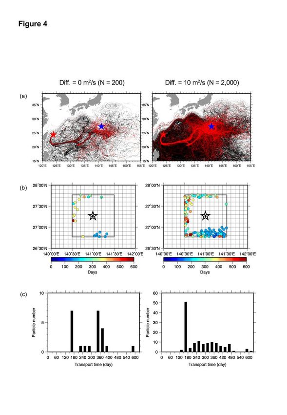
Figure 4a shows all particle trajectories for the two experiments. In the experiments
without and with horizontal diffusion, 23 and 137 particles were back-transported into
the target area, respectively. Figure 4b shows the ‘arrival’ points and transport durations
of those particles. The shortest and longest transport times were 140 and 602 days,
respectively. The transport times of particles that ‘arrived’ to the west of Nishinoshima
tended to be longer than those of particles that ‘arrived’ to the south. There was no specific
tendency among the transport times in the experiment without diffusion, whereas
transport times of 150–180 days were by far the most common in the experiment with
diffusion (Fig. 4c).
4. Discussion
4-1. Circumstances of the OBEMs on the seafloor and implications for volcanic
9activity at Nishinoshima
In addition to finding JM4 on Iriomote Island, our simulation results with and without
horizontal eddy diffusion indicate that 7–10% of the particles around Iriomote Island on
18 February 2021 were transported from around Nishinoshima within the preceding two
years. Thus, we suggest that sea-surface transport from the Bonin Islands to the Ryukyu
Islands and Taiwan is not a rare occurrence. In addition, the shortest transport time we
obtained (140 days) is consistent with the lengths of barnacles attached to JM4, which
must have been attached for at least 50 days before its retrieval. However, the simulated
transport durations varied widely between 140 and 602 days depending on the drift path.
Indeed, Nishinoshima and Iriomote Island are situated in the North Pacific Subtropical
Gyre; a particle transported from Nishinoshima can arrive at Iriomote Island in half a year
if it is carried by a relatively strong sea current, whereas one trapped in medium-sized
eddies will take much longer. More detailed insight into the path and duration of drift of
JM4 will require further comparison between drifting simulations and barnacle growth
histories. Here, we discuss what may have happened to the OBEMs on the seafloor and
constrain the period during which JM4 must have floated to the sea surface, which might
be related to previously unknown submarine volcanic activity. This information will be
useful for detecting when pumices were erupted from the Bonin Islands and how long
they drifted before reaching the Ryukyu Islands.
OBEMs JM4 and JM6 were not recoverable by conventional means in June 2019 (see
section 2). The other four recovered OBEMs were not installed between JM4 and JM6
and had only moved 9 – 15 m, much shorter distances than JM4 and JM6. Therefore,
these two OBEMs were probably moved by external forces such as a failure of the
unstable volcanic slope and/or crustal deformation associated with the intrusion of
magma. Such seafloor occurrences might not be correlated with known activity at
Nishinoshima, may have occurred locally to the south and east of the island, and may not
have been detectable above the sea surface.
There are three possible reasons why JM4 and JM6 did not ascend from the seafloor
in June 2019: (1) the release systems did not work, even though they responded normally
to the release commands; (2) the weights may have been released, but the glass spheres
containing the fluxgate sensors and recorders may have been flooded, preventing the
10buoyant rise of the OBEMs; or (3) the weights may have been released, but the OBEMs
were stuck in sediments and could not ascend. Because JM4 was found without its weight
and with its two glass spheres still under vacuum, we reject the first two possibilities and
conclude that JM4 had become stuck in sediments. Unfortunately, JM6 has not yet been
found and we cannot say whether it remains on the seafloor or is adrift in the ocean.
It is important to constrain when JM4 rose from the seafloor because its release from
the sediments might be related to previously unknown submarine volcanic activity that
could not be otherwise detected (e.g., visually or by satellite). JM4 was confirmed to be
on the seafloor on 11 June 2019 and was found 601 days later on Iriomote Island on 18
February 2021. However, its data log indicates that it was on the seafloor at least until 24
August 2019 when its sensor’s batteries were completely exhausted, and the temperature
time series remained at ~1.0 °C from the end of February 2019 through the end of August
2019. If JM4 had risen to the surface during this period, the temperature would have
increased because the ocean temperature increases at shallower depths. Therefore, JM4
must have remained on the seafloor at least until 24 August 2019. Unfortunately, the
tiltmeters failed around the end of February 2019, so we cannot use the tilt data to further
confirm this conclusion. From the recorded data, we can only determine that the longest
possible duration of drift for JM4 was 527 days. According to the results of our drifting
simulations, it is unlikely that JM4 drifted for longer than 480 days; of the particles that
‘arrived’ at Nishinoshima, only 1 of 23 and 5 of 137 simulations without and with eddy
diffusion, respectively, had longer residence times (Fig. 4c). Hence, JM4 most likely
remained on the seafloor for at least a few months after February 2019.
Based on our simulations, the most likely duration of transport for JM4 is 150–180
days (Fig. 4c). These transport durations correspond to JM4 rising from the seafloor
between 22 August and 21 September 2020. Nishinoshima began an eruptive period on 5
December 2019 that ceased at the end of August 2020. During that period, the eruptive
style changed from Strombolian to violent Strombolian in mid-June 2020 (Yanagisawa
et al. 2020). Violent Strombolian eruptions produce dense volcanic plumes, abundant ash,
and lava flows (Pioli et al. 2008; Valentine and Gregg 2008). Indeed, Yanagisawa et al.
(2020) observed a lava flow entering the sea on 20 July 2020. These eruptive events
shortly precede the most likely dates for JM4 to have been released (22 August to 21
September 2020). Thus, we consider that volcanic materials entering the sea may have
11dislodged JM4 either by disturbing the seafloor sediments or gently jostling it loose.
4-2. Implications for drifting pumices in the Ryukyu Islands
Just as JM4 was found on the beach on Iriomote Island, many pumices are found on
beaches in the Ryukyu Islands (e.g., Kato 1980, 1988; Nakano and Kawanabe 1992).
Kato (1988) reported that many pumices had been stranded on the Ryukyu Islands since
late May 1986. Based on the mineralogy and geochemistry of the pumices, he concluded
that they were effused during the 18–21 January 1986 eruption of Fukutoku-Oka-no-Ba
(Fig. 1), thus indicating a distance and duration of drifting similar to those determined for
OBEM JM4. This similarity indicates that in both cases, drifting was mainly affected by
two currents: the Kuroshio counter-current, which flows from east to west at middle
latitudes in the Pacific Ocean, and the Kuroshio current, which flows from the eastern
shores of the Philippine and Taiwan to the Ryukyu islands.
It is generally difficult to specify the origin of drift pumices. For example, the origins
of most drift pumices on Iriomote Island cannot be identified, although one type has been
correlated to Fukutoku-Oka-no-Ba based on color, clast size, mineralogy, and
geochemistry (Nakano and Kawanabe 1992). Our drifting simulation might therefore be
used to quantitatively evaluate possible drift pumice origins. The tracking paths obtained
in our simulation (Fig. 4a) reach Taiwan, the Philippines, and the Mariana Islands, which
were mentioned as possible pumice origins by Nakano and Kawanabe (1992). Moreover,
such drifting simulations might be useful in constraining the duration of volcanic
activities and detecting otherwise undetectable eruptions of submarine volcanoes.
Nakano and Kawanabe (1992) also reported that marine organisms were attached to drift
pumices. As we have demonstrated, integrating biomarker analyses with drifting
simulations can further narrow the possible origins and drift paths/durations of pumices.
On 13 August 2021, a submarine eruption occurred at Fukutoku-Oka-no-Ba, and a
new horseshoe-shaped island 1 km in diameter was observed on 16 August. Aerial
photographs and satellite images show numerous pumice rafts drifting to the northwest
(Japan Meteorological Agency 2021). Pumice rafts are known to cause various hazards,
such as blocking harbors, ports, and marine traffic, and damaging hulls and propellers
(e.g., Oppenheimer 2003; Jutzeler et al. 2014). Drifting simulations could also be used to
12predict possible paths of pumice rafts, and thus potential risks (Jutzeler et al. 2014, 2020).
Indeed, Jutzeler et al. (2020) recently tried to predict the ongoing dispersal of pumice
rafts from the Tonga Arc (southwestern Pacific Ocean) using the latest-monitored ocean
current data for forecast simulations.
We stress, however, that the drifting simulation have presented here does not provide
a forecast; it is a hindcasting simulation. In addition, it does not consider the effect of
wind, which likely impacts the paths of large, light drift pumices. Nonetheless, our
simulation results and observational evidence that many pumices from Fukutoku-Oka-
no-Ba, as well as the JM4 OBEM from Nishinoshima, arrive in the Ryukyu Islands
suggest that the pumices rafts erupted in August 2021 will likely move westward and drift
ashore in the Ryukyu Islands in several months. As of this writing (23 September 2021),
we have begun drifting simulations to forecast such an eventuality.
5. Conclusions
OBEM JM4 was deployed on the seafloor near Nishinoshima in 2018 and was found
ashore on Takana beach on Iriomote Island in February 2021, which motivated us to
simulate its drifting path and duration. Our results indicate that material drifting from the
Bonin Islands have a 7–10% probability of being carried by westward ocean currents to
the Ryukyu Islands. Whether ignoring or accounting for horizontal eddy diffusion in our
simulations, the most likely drift duration for JM4 was 150–180 days, corresponding to
its release from the seafloor between 22 August and 21 September 2020. Nishinoshima
volcano began erupting in late December 2019, and the eruptive style changed from
Strombolian to violent Strombolian in mid-June 2020, producing lava flows that entered
the ocean by late July 2020 (Yanagisawa et al. 2021). However, these activities were
confirmed only from above sea level, and we do not yet know the extent to which they
effected the submarine landscape around Nishinoshima. We hypothesize that this eruptive
activity caused JM4 to rise to the sea surface. It is important to further constrain the
drifting duration of JM4 because it will reveal when volcanic activities affected the
eastern slope of Nishinoshima where JM4 was installed. More accurate information may
be obtained from the growth record of the barnacles on JM4. The drifting path and
duration of JM4 are similar to those of drift pumices from the Fukutoku-Oka-no-Ba
13submarine volcano, which have been found in the Ryukyu Islands. Our drifting
simulation may therefore also contribute to determining the origins of drift pumices and
constraining the duration of related volcanism.
Declarations
Ethics approval and consent to participate
Not applicable.
Consent for publication
Not applicable.
List of abbreviations
JMA, Japan Meteorological Agency; OBEM, ocean bottom
electromagnetometer; ROV, remotely operated vehicle; JAMSTEC,
Japan Agency for Marine-Earth Science and Technology
Availability of data and materials
Contact the corresponding author to access the digital data for the
drifting simulation.
Competing interests
The authors declare that they have no competing interests regarding this
study.
14Funding
This research was supported in part by KAKENHI Grant Numbers
18H01319 from the Japanese Ministry of Education, Culture, Sports,
Science and Technology, and CREST Grant Number JPMJCR1761 and
PRESTO JPMJPR1876 from Japan Science and Technology Agency.
Authors' contributions
NT contributed to shipboard OBEM observations. NT and HI retrieved
the JM4 OBEM from Iriomote Island. HN performed the drifting
simulation. HW contributed to studying the marine organisms on the
retrieved OBEM. NT, HN, and TK contributed funding to this study. All
authors contributed to discussions and have approved the final
manuscript.
Acknowledgements
The authors thank Iriomote Island Eco-Tourism Association and their
volunteers for finding and reporting the OBEM, and for their kind
cooperation during its recovery. The Japan Oceanographic Data Center
of the Japan Coast Guard provided bathymetric data around Nisihoshima
and Iriomote Islands. The figures were produced using Generic Mapping
Tools v5 (Wessel et al. 2013).
Authors' information
15Not applicable
References
Amente, C., Eakins, B. W. (2009) ETOPO1 1 Arc-Minute Global Relief Model:
Procedures, Data Sources and Analysis. NOAA Tech. Memo. NEDIS NGDC-24. Natl
Geophys Data Center, NOAA. https://doi.org/10.7289/V5C8276M
Arai, K., Naruse, H., Miura, R., Kawamura, K., Hino, R., Ito, Y., Inazu, D., Yokokawa,
M., Izumi, N., Murayama, M., Kasaya, T. (2013) Tsunami-generated turbidity current
of the 2011 Tohoku-Oki earthquake. Geology 41, 1195-1198.
https://doi.org/10.1130/G34777.1
Baba, K., Tada, N., Ichihara, H., Hamano, Y., Sugioka, H., Koyama, T., Takagi, A.,
Takeo, M. (2020) Two independent signals detected by ocean bottom
electromagnetometers during a non-eruptive volcanic event: Ogasawara Island arc
volcano, Nishinoshima. Earth Planets Space 72: 112. https://doi.org/10.1186/s40623-
020-01240-z
Inatsuchi, A., Yamato, S., Yusa, Y. (2010). Effects of temperature and food availability
on growth and reproduction in the neustonic pedunculate barnacle Lepas
anserifera. Marine Biology, 157(4), 899-905. https://doi.org/10.1007/s00227-009-
1373-0
Japan Agency for Marine-Earth Science and Technology (2011) R/V Natsushima Cruise
Report NT11-08. pp 23.
Japan Agency for Marine-Earth Science and Technology (2012) R/V Kairei Cruise
Report KR12-15. pp 26.
Japan Meteorological Agency (2013) Meso-Scale Model (JMA-MSM1206). Outline of
the operational numerical weather prediction at the Japan Meteorological Agency, 71-
93.
Japan Meteorological Agency (2021) Explanatory material for volcanic activity in
Fukutoku-Oka-no-Ba.
https://www.data.jma.go.jp/svd/vois/data/tokyo/STOCK/monthly_v-
act_doc/tokyo/21m08/202108161400_331.pdf (in Japanese)
Jutzeler, M., Marsh, R., Carey, R. J., White, J. D. L., Talling, P. J., Karlstrom, L. (2014).
16On the fate of pumice rafts formed during the 2012 Havre submarine eruption. Nature
Communications 5(1), 3660. https://doi.org/10.1038/ncomms4660.
Jutzeler, M., Marsh, R., van Sebille, E., Mittal, T., Carey, R. J., Fauria, K. E., et al. (2020).
Ongoing dispersal of the 7 August 2019 pumice raft from the Tonga arc in the
southwestern Pacific Ocean. Geophysical Research Letters 47, e1701121.
https://doi.org/10.1029/2019GL086768
Kato, Y. (1980) Petrology of Recent pumice from the Ryukyu Islands-A preliminary
report. Geological Study of Ryukyu Islands. Bulletin of Volcanological Society of
Japan 5, 69-73 (in Japanese with English abstract)
Kato Y. (1988) Gray pumices drifted from Fukutoku-oka-no-ba to the Ryukyu Islands.
Bulletin of Volcanological Society of Japan 33, 21-30 (in Japanese with English
abstract)
Naif, S., Key, K., Constable, S., Evans, R.L. (2013) Melt-rich channel observed at the
lithosphere-asthenosphere boundary. Nature 495 (7441):356-359.
https://doi.org/10.1038/nature11939
Nakano S, Kawanabe, Y. (1992) Pumices Drifted to Iriomote Island in 1991. Bulletin of
Volcanological Society of Japan 37(2), 95-98. (in Japanese with English abstract)
Oppenheimer, C. (2003). Climatic, environmental and human consequences of the largest
known historic eruption; Tambora Volcano (Indonesia) 1815. Progress in Physical
Geography 27(2), 230–259. http:// doi.org/10.1191/0309133303pp379ra
Pioli, L., Erlund, E., Johnson, E., Cashman, K., Wallace, P., Rosi, M., Delgado Granados,
H. (2008) Explosive dynamics of violent Strombolian eruptions: The eruption of
Parícutin Volcano 1943-1952 (Mexico). Earth Planet Sci Lett 271, 359-368. https://
doi.org/10.1016/j.epsl.2008.04.026
Seama, N., Baba, K., Utada, H., Toh, H., Tada, N., Ichiki, M., Matsuno, T. (2007) 1-D
electrical conductivity structure beneath the Philippine Sea: Results from an ocean
bottom magnetotelluric survey. PEPI 162, 2-12.
https://doi.org/10.1016/j.pepi.2007.02.014
Tada, N., Tarits, P., Baba, K., Utada, H., Kasaya, T., Suetsugu, D. (2016) Electromagnetic
evidence for volatile-rich upwelling beneath the society hotspot, French Polynesia.
Geophys Res Lett 43 (23):12021-12026. https://doi.org/10.1002/2016gl071331
Tamura, Y., Sato, T., Fujiwara, T., Kodaira, S., Nichols, A. (2016) Advent of Continents:
17A New Hypothesis. Sci Rep-Uk 6. https://doi:10.1038/srep33517
Valentine, G. A., Gregg, T. K. P. (2008) Continental basaltic volcanoes -Processes and
problems. J Volcanol Geotherm Res 177, 857-873.
https://doi.org/10.1016/j.jvolgeores.2008.01.050
Wessel, P., Smith, W. H. F., Scharroo, R., Luis, J., Wobbe, F. (2013) Generic mapping
tools: improved version released. Eos. Trans. AGU 94(45):409-410.
https://doi.org/10.1002/2013EO450001
Yanagisawa, H., Iino, H., Ando, S., Takagi, A., Oikawa, T. (2020) Violent Strombolian
Eruption from June to August 2020 of Nishinoshima Island, Ogasawara Islands, Japan.
Bulletin of Volcanological Society of Japan 65(4): 119-124.
https://doi.org/10.18940/kazan.65.4.119 (in Japanese with English abstract)
Figure legends
Figure 1 (a) Bathymetric map (ETOPO1, Amente and Eakins 2009) of the Philippine
sea and western Pacific Ocean showing the locations of Iriomote Island, Nishinoshima
Island, and the Fukutoku-Oka-no-Ba submarine volcano (red circle). (b) Iriomote
Island; the red star indicates where OBEM JM4 was discovered on 18 February 2021.
(c) Nishinoshima Island; the blue star indicates the last known seafloor position of JM4
on 10 June 2019.
Figure 2 Photographs of OBEM JM4 (a) just before deployment during cruise KS18-
07 and (b) when it was found on Iriomote Island by the Iriomote Eco-Tourism
Association.
Figure 3 (a) Initial particle positions around Iriomote Island in the particle back-
tracking simulations. Dots are the initial particle positions, and the center of the star
18marks where the OBEM was found on the beach. These initial positions were set to
include only the eastern side of the true arrival position because much of the western
side includes the island itself, and because the arrival site faces the east. (b) Target area
around Nishinoshima in the particle back-tracking simulations. The thick square
encloses the 1° × 1° target area around Nishinoshima (center of the star). Any particles
that were traced back to this target area were considered to have originated from
Nishinoshima.
Figure 4 Particle back-tracking simulations without (left, 200 particles) and with
(right, 2,000 particles) horizontal eddy diffusion (horizontal diffusion coefficient = 10
m2/s). (a) Daily particle positions from 18 February 2021 to 10 June 2019.
Nishinoshima and Iriomote Islands are indicated by the blue and red stars, respectively.
Red traces represent the tracks of particles that ‘arrived’ (i.e., originated from) within
the Nishinoshima target area. (b) Original positions of particles calculated to have
originated from within the target area. The center of the star represents Nishinoshima
Island. The color scale represents the back-transport duration from Iriomote Island. (c)
Distributions of back-transport times in each simulation.
19Figures Figure 1 (a) Bathymetric map (ETOPO1, Amente and Eakins 2009) of the Philippine sea and western Paci c Ocean showing the locations of Iriomote Island, Nishinoshima Island, and the Fukutoku-Oka-no-Ba submarine volcano (red circle). (b) Iriomote Island; the red star indicates where OBEM JM4 was discovered on 18
February 2021. (c) Nishinoshima Island; the blue star indicates the last known sea oor position of JM4
on 10 June 2019.

Figure 2

Photographs of OBEM JM4 (a) just before deployment during cruise KS18-07 and (b) when it was found
on Iriomote Island by the Iriomote Eco-Tourism Association.
Figure 3

(a) Initial particle positions around Iriomote Island in the particle back-tracking simulations. Dots are the
initial particle positions, and the center of the star marks where the OBEM was found on the beach. These
initial positions were set to include only the eastern side of the true arrival position because much of the
western side includes the island itself, and because the arrival site faces the east. (b) Target area around
Nishinoshima in the particle back-tracking simulations. The thick square encloses the 1° × 1° target area
around Nishinoshima (center of the star). Any particles that were traced back to this target area were
considered to have originated from Nishinoshima.

Figure 4

Particle back-tracking simulations without (left, 200 particles) and with (right, 2,000 particles) horizontal
eddy diffusion (horizontal diffusion coe cient = 10 m2/s). (a) Daily particle positions from 18 February
2021 to 10 June 2019. Nishinoshima and Iriomote Islands are indicated by the blue and red stars,
respectively. Red traces represent the tracks of particles that ‘arrived’ (i.e., originated from) within the
Nishinoshima target area. (b) Original positions of particles calculated to have originated from within the
target area. The center of the star represents Nishinoshima Island. The color scale represents the back-
transport duration from Iriomote Island. (c) Distributions of back-transport times in each simulation.

Supplementary Files
This is a list of supplementary les associated with this preprint. Click to download.

    GraphicalAbstv1.png
You can also read