NASA Earth Science Division Response to the 2017 ESAS Decadal Survey: SSB Agency Roundtable - Michael Freilich
←
→
Page content transcription
If your browser does not render page correctly, please read the page content below

NASA Earth Science Division Response        Michael Freilich

to the 2017 ESAS Decadal Survey:
                                            Division Director
                                       Earth Science Division

SSB Agency Roundtable                              May 2, 2018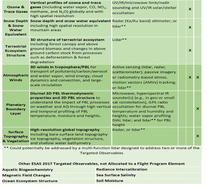
2017 Decadal Survey Snapshot
  2017 DECADAL SURVEY   • Publicly released January 5, 2018

                        • Supports the ESD (and international) Program of Record

                        • Prioritizes observations rather than specific missions

                        • Emphasis on competition as cost-control method

                        • Explicitly allows implementation flexibility

                        • Explicitly encourages and notes value of international
                          partnerships

                        • Endorses existing balances in ESD portfolio
                                                                                   2
(Pre)Formulation
    Implementation
                          NASA Earth Science                                                                                                                   Landsat 9 (2020)
                                                                                                                                                        PACE (2022)

    Primary Ops           FY17 Program of Record                                                                                              GeoCARB (~2021)

    Extended Ops                                                                                                               TROPICS (12) (~2021)
                                                                                                                     MAIA (~2021)
                                                                                                         Sentinel-6A/B (2020, 2025)
                                                                                              NI-SAR (2021)
ISS Instruments                                                                      SWOT (2021)
CATS, LIS (2020), SAGE III (2020)                                         TEMPO (2018)                                                                      Invests/CubeSats
TSIS-1 (2020) OCO-3 (2018),                                    GRACE-FO (2) (2018)                                                                          RAVAN (2016) ✔
ECOSTRESS (2018), GEDI (2018)                                                                                                                               IceCube (2017) ✔
CLARREO-PF (2020)                                                                                           NISTAR, EPIC
                                                                      ICESat-2 (2018)                                                                       MiRaTA (2017) ✔
                                                                                        CYGNSS (8) (2019)   (DSCOVR / NOAA)
                                                                                                            (2019)                                          HARP (2018)
JPSS-2 Instruments                                 Suomi NPP
                                                                          SMAP                                                                              TEMPEST-D (2018)
                                                                          (>2022)                                                                           RainCube (2018)
RBI (2018), OMPS-Limb (2018)                       (NOAA)
                                                   (>2022)                                                                                                  CubeRRT (2018)
                                                                                  Landsat 7        QuikSCAT     SORCE,                                      CIRiS (2018*)
                                                                                  (USGS)           (2017)       TCTE (NOAA)                                 CIRAS (2018*)
                                                                    Terra (>2021)                               (2017)
                                                                                  (~2022)                                                                   CSIM (2018)
                                       Landsat 8
                                       (USGS)                                                                                                               LMPC (TBD)
                                                                        Aqua (>2022)
                                       (>2022)
                                                                                                                                                            * Target date,
                                                                                      CloudSat (~2018)                                                        not yet manifested
                                    GPM (>2022)                                                          CALIPSO (>2022)

                                                                                                                       Aura (>2022)
                                            OCO-2 (>2022)                                                                             OSTM/Jason-2 (NOAA)
                                                                                                                                      (>2022)
                                                                                                                                                                                   3
2017 Decadal Survey Snapshot (cont.)
• Recommends “Continuity Measurement” strand ($150M full mission cost cap)
2017 DECADAL SURVEY as an addition to the existing Venture-class program
• Identifies 5 ”Designated” observables for mandatory acquisition (Aerosols;
Clouds, Convection, & Precipitation; Mass Change; Surface Biology &
Geology; Surface Deformation & Change)
• Calls for “cost-capping” essentially all missions
• Introduces a new competed “Explorer” flight line with $350M cost constraint, 3
observables to be chosen by ESD from among 6 identified
• Calls for “Incubator Program” between Technology, R&A, and Flight to mature
specific technologies for important – but presently immature – measurements
(preparation for next Decadal)
• ESD is conducting focused community forums (for 12-18 months) to
translate the recommendations into an executable program and, for
Flight, a portfolio of specific, realistic, launch-ordered missions and
solicitations.
Decadal new mission budget wedge opens late FY21
First full community forum May 10, 2018 (HQ and online)
4
Communicating our plans and progress:
    • ESD’s Decadal Survey web page:
        https://science.nasa.gov/earth-science/decadal-surveys
    • Use the web page to…
       •   See meeting and telecon announcements
       •   Ask questions
       •   Find answers to questions, as they become available
       •   View records of progress and decisions

                                                                 5
International Engagement
• ESD has conducted focused Decadal Survey telecons/meetings with key
  international partners
   • CNES, CSA, DLR, ESA, EUMETSAT, ISRO, JAXA
   • Bilateral, HQ-level, face-to-face meetings planned over the next 6 months
   • Some directed international partnerships may originate from ESD/HQ
• Centers are explicitly encouraged to discuss and explore possible observable
  implementation approaches with international partners
   • Multi-center joint efforts appreciated
   • Keep ESD leadership informed
• ESD will make final partnership determinations and then codify necessary
  international agreements
                                                                                 6
NASA Earth Science Partners
Current Operating Missions                                                               OSTM/Jason-2
                                                                                         (NOAA, CNES)

                                                                       Terra
                                                                       (CSA,METI,
                                                                       INPE)
                                                ISS: SAGE III
                                                (ESA)

                                   Aqua
                                   (JAXA)

                                                           Landsat 7
                                                           (USGS)
                                                                            Aura
                                                                            (FMI, NVR,
                                                                            NERC)
                                 Suomi NPP   NISTAR, EPIC
                                 (NOAA)      (DSCOVR / NOAA)

                                                       TCTE            CALIPSO
                     Landsat 8
                                                       (NOAA)          (CNES)
                     (USGS)
                                                                                         CloudSat
                                                                                         (USAF,
                                                                                         CSA)
            GPM
            (JAXA,
            NICT)
                                                                                                        02.06.18
ESD Partnership Missions in Development
GRACE FO
LRD: Apr 2018 Sentinel 6A/B Landsat 9 SWOT
Global mass & water variation ABC: 2021 NISAR
ABC: 2021/2026 ABC: Apr 2022 ABC: Sep 2022
Ocean Altimetry Land Imaging Sea surface & fresh water Cryosphere,
Partner: GFZ height, slope ecosystems, deformation
Science & science processing Partner: NOAA Partner: USGS
Mission operations Science data dissemination Ground system Partner: CNES
Mission Operations Partner: ISRO
Optical Ground stations Spacecraft bus S-Band SAR
components of Laser Ranging Science instruments Spacecraft bus
Instrument Partner: ESA (Nadir Altimeter, Spacecraft operations
Launch Services Spacecraft bus DORIS, KaRIn RF Science Downlink
Science instruments (Poseidon-4 Unit subsystem) S-Band processing
Altimeter, DORIS, GNSS POD)
Satellite control center (during Partner: CSA
LEOP) Klystrons for KaRIn
Partner: EUMETSAT Partner: UKSA
Mission/System coordinator, Duplexers for KaRIn * Implementation = Phase C/D
Satellite control center (Ops)
Science data processing **Delivery of payload to host
Science data dissemination
Data archiving ABC=Agency Baseline Commitment
Ground stations
Earth Venture Continuity (EVC) Decisions

                                           9
ESD Top Level Approach to EVC
• ESD will use EVC to demonstrate a technique/approach for making long-term
  measurements with the appropriate characteristics (a “continuity demonstration”)

• Criteria for selecting an EVC project:
    –   Capability of the instrument/characteristics of the data
    –   Cost of future copies
    –   Accommodatability
    –   Producibility
    –   Ease of technology infusion (optional)

• Payload Classification will be Class C or D, as stated in the AO for a specific
  solicitation
• EVC will NOT address continuity beyond the demonstration
   – Minimum demonstration period is 1 year beyond on-orbit commissioning
    – Additional on-orbit acquisition will not be under the cost cap

•   The ESD objective will be to fly 3 EVC missions in the decade                    10
Targeted Solicitations
• Given the RBI termination, EVC-1 will be a targeted AO for radiation budget
capability
• Future EVC solicitations may:
• Target a single observation for a given imperative (similar to EVC-1)
• Target a set of observations (e.g. solar irradiance, ozone, and CO2)
• ESD will maintain the flexibility to pursue either of the above options, but it is
expected that most will be single observation targeted
• However, once we know what we want to do with the next EVC, ESD will alert the
community to our intentions
11Designated Observables (DO) – Decisions
12Designated Observables Summary
ESAS maximum
Observable Science/Applications Summary Candidate Measurement cost
Approach
Aerosols Aerosol properties, aerosol vertical profiles, and cloud Backscatter lidar and multichannel/multi- CATE Cap
properties to understand their effects on climate and air angle/polarization imaging radiometer flown
quality together on the same platform
$800M
Clouds, Convection, Coupled cloud-precipitation state and dynamics for Radar(s), with multi-frequency passive CATE Cap
And Precipitation monitoring global hydrological cycle and understanding microwave and sub-mm radiometer
contributing processes including cloud feedback
$800M
Mass Change Large-scale Earth dynamics measured by the changing Spacecraft ranging measurement Est Cap
mass distribution within and of gravity anomaly
between the Earth’s atmosphere, oceans, ground water,
$300M
and ice sheets
Surface Biology and Earth surface geology and biology, Hyperspectral imagery in the CATE Cap
Geology ground/water temperature, snow reflectivity, active visible and shortwave infrared,
geologic processes, vegetation traits and algal biomass multi- or hyperspectral imagery in the thermal
$650M
IR
Surface Earth surface dynamics from earthquakes and landslides Interferometric Synthetic Aperture Radar Est Cap
Deformation and to ice sheets and permafrost (InSAR) with ionospheric correction
Change $500M
13Designated Missions/Observing Systems
Sequencing to Meet DS Objectives
• First two missions/observing systems
– Surface Biology and Geology (Budget:ESD DO Programmatic Architecture
• Designated Observables Studies
– Rapid solicitation for Multi-Center Study Proposals
– Specific direction for expectations
– A target KDP-A Date will be provided in early FY19 to the study teams for the first two D.O.s
(SBG; Aerosols/CPP)
• Mission Responsibility
– Directed to NASA Centers
• Instruments
– Partner Contributions
– Competed via Announcement of Opportunity (SMD/ESD selection)
• Spacecraft
– Partner Contributions
– RFP to Industry by the NASA Center responsible for the mission
15Designated Observable Studies
• DRAFT Scope of Mission Studies
– Develop top-level objectives
– Identify potential international and/or interagency partners, and/or private sector participation
– Synergies with other D.O., ESD, or non-NASA missions
– Identify needed technology refinement efforts, precursor campaigns, and post launch validation
– Conduct Airborne campaigns
– Run OSSEs
– Develop required capability for mission and instruments
– Sequencing/approach for instrument/spacecraft development (i.e. approach for designing the
spacecraft without knowing the instrument interfaces, or vice-versa)
– Recommend cost target for instruments
– Application community assessments
• Study scope will be refined in the coming weeks and included in the call for multi-
center mission study proposals
16Questions?
1718
NASA Earth Science Division Elements

       Flight (incl. Data Systems)                                Research & Analysis
Develops, launches, and operates NASA’s fleet of         Supports integrative research that advances
Earth-observing satellites, instruments, and aircraft.   knowledge of the Earth as a system. Six focus areas
Manages data systems to make data and information        plus field campaigns, modeling, and scientific
products freely and openly available.                    computing.

      Technology                                                  Applied Sciences
Develops and demonstrates technologies for future        Develops, tests, and supports innovative uses of Earth
satellite and airborne missions: Instruments,            observations and scientific knowledge to inform private
Information Systems, Components, InSpace Validation      and public sector planning, decisions, and actions.
(cubesat and small-sat form factors).                    Activities include disaster response support and capacity
                                                         building.
                                                                                                                     19
R&A Selected Highlights
• Field Work
• 2018 Cloud and Aerosol Monsoonal Processes Exp’t (near Phillipines); EXPORTS field program (NE Pacific; in
coordination with NSF), FLARE (Alaska), HyspIRI (Hawaii), ABoVE (surface only); 2019 FIREChem (Kansas; with NOAA)
• New Competed Science Programs (highlights only – many ROSES calls)
• Selected new round of Interdisciplinary Science investigators – 28 principal investigators – 5 topics, $34M over three years
• Solicited for competed science teams for newly launched missions/instruments (CYGNSS, SAGE III), new combined
Terra/Aqua/Suomi-NPP science
• Modeling and Data Assimilation
• GMAO evolved and transitioned to a “hybrid 4D VAR” data assimilation system
• Enabling Capabilities
• Built a modular computing facility at ARC and expanded SMD’s supercomputing capacity to 6 pflops; expanded capacity at
NCCS to 3.5 pflops.
• Installed antenna at MSFC for real-time receipt of GOES-16 for SPoRT (jointly with NOAA); antenna for GOES-S on order
• Purchased 60 new/improved/reliable sensors for AERONET to replace ~20% of existing sensors in 2018
20Earth Science Technology
Advanced Technology IIP AIST
Initiatives (ATI)
ACT InVEST Instrument Incubator Advanced Information
Program Systems Technology
Advanced Component In-Space Validation Robust new instrument Innovative advances in
Technologies of Earth Science Tech. developments and on-orbit and ground
Development of critical On-orbit technology validation measurement techniques technologies to generate,
components and and risk reduction for small manage, and exploit data
subsystems for instruments and instrument 17 new projects awarded in the 5-20 year horizon
instruments & platforms systems that could not other- in FY17. Future
wise be fully tested on the solicitations/ 22 new projects awarded
12 projects awarded in selections planned in FY in FY17. Future
2018. Future ground or in airborne systems.
2019 and FY 2022 solicitations/selections
solicitations/selections Future solicitations/selections planned in FY 2018,
planned in FY 2020 and planned in FY 2018 & FY FY 2020 and FY 2022
FY 2023 2021 21Applied Sciences Program: Selected Highlights–2018
Disasters Food Security and SERVIR
ROSES call for applications Agriculture Consortium New Amazonia regional hub for South
focused on a few disaster types – New effort led by UMd to advance America is planned to open in Spring.
flood, hurricane, earthquake. uses of Earth obs for humanitarian
pursuits, economic growth, and DEVELOP
Water Resources resilience in food systems in U.S. 2018 marks the 20th year for this
Call to support water resources and globally. development, workforce & Earth
management. Two-step process science applications program.
planned. Impact Assessments ARSET Trainings
Sustainable VALUABLES Consortium Over 15 professional-level hands-on
Development Goals conducting economic studies on and webinar trainings on remote
Earth science; also arranging sensing to reach people across all 50
Earth science call for applications
venues for Earth scientists wanting U.S. States again in 2018.
and research on SDG 14 (oceans)
to learn about policy and economic
and SDG 15 (life on land).
terms/methods.
A P P LI CATI O NS A RE AS | M I S S I O N S UP P O RT | C APACI TY B UI LDI NG http://AppliedSciences.NASA.gov
22Earth Science Partnerships
Harnessing commercial and NGO partnerships to amplify our work to understand the Earth as an
integrated system and enable societal benefit by essentially leveraging the expertise of NASA and
the partners to achieve together what neither could alone.
Current Partners
Activities
• Advancing the ability of remote sensing to inform
economic valuation of ecosystem services
• Increasing the public’s access to and use of
Earth observations to explore our planet
• Integrating Earth observations into humanitarian decision making to strengthen
global resilience to environmental shocks and stressors
• Supporting decision making in smart cities by integrating Earth observations into
cloud-based servicesProgress Since ESAS 2007
Finding 2A: The NASA ESD program has
made important progress during the
decade, partially recovering from the
underfunded state it was in a decade
ago . . .
Finding 2B: NOAA progress during the
decade was hampered by major
programmatic adjustments . . .
Finding 2C: The USGS has transformed
the Landsat program via the Sustainable
Land Imaging (SLI) program . . .
24NASA Portfolio Balance
• Earth Science research: maintain at approximately 24%
of the budget (22-26%)
• Includes 18% for openly competed research and analysis
• Includes approximately 3% each for computing and
administration
• Applications program: maintain at 2-3% of the budget
• Technology program: increase from its current 3% to
about 5%
• Flight programs, including Venture: maintain at 50-60%
of the budget
• Mission Operations: maintain at 8-12% of the budget
25Quick Summary of Recommendations
2 SCIENCE & APPLICATIONS
Address 35 key science/applications questions, from among hundreds
suggested. Highest priority objectives fell into six categories:
• Coupling of the Water and Energy Cycles
• Ecosystem Change
• Extending & Improving Weather and Air Quality Forecasts
• Sea Level Rise
1 • Reducing Climate Uncertainty & Informing Societal Response 4
• Surface Dynamics, Geological Hazards and Disasters
VISION & STRATEGY PROGRAMMATICS
“Thriving on our 3 OBSERVATIONS • CROSS-AGENCY
Changing Planet” Augment the Program of Record with eight priority • NASA
observables: • Flight
• Five that are specified/designated to be implemented: • Technology
• Aerosols
• Clouds, Convection, & Precipitation
• Applications
• Mass Change • NOAA
• Surface Biology & Geology • USGS
• Surface Deformation & Change
• Three others to be selected competitively from among six candidates
• Structure new mission program elements to accomplish this 26Summary of Top Science and
Applications Priorities* * Complete set of Questions and
Science & Science & Applications Questions
Objectives in Table 3.3
Applications Topic addressed by MOST IMPORTANT Objectives
Coupling of the Water (H-1) How is the water cycle changing? Are changes in evapotranspiration and precipitation accelerating, with
and Energy Cycles greater rates of evapotranspiration and thereby precipitation, and how are these changes expressed in the space-time
distribution of rainfall, snowfall, evapotranspiration, and the frequency and magnitude of extremes such as droughts
and floods?
(H-2) How do anthropogenic changes in climate, land use, water use, and water storage interact and modify the
water and energy cycles locally, regionally and globally and what are the short- and long-term consequences?
Ecosystem Change (E-1) What are the structure, function, and biodiversity of Earth’s ecosystems, and how and why are they changing
in time and space?
(E-2) What are the fluxes (of carbon, water, nutrients, and energy) between ecosystems and the atmosphere, the
ocean and the solid Earth, and how and why are they changing?
(E-3) What are the fluxes (of carbon, water, nutrients, and energy) within ecosystems, and how and why are they
changing?
Extending & (W-1) What planetary boundary layer (PBL) processes are integral to the air-surface (land, ocean and sea ice)
Improving Weather exchanges of energy, momentum and mass, and how do these impact weather forecasts and air quality simulations?
and Air Quality (W-2) How can environmental predictions of weather and air quality be extended to seamlessly forecast Earth
Forecasts System conditions at lead times of 1 week to 2 months?
(W-4) Why do convective storms, heavy precipitation, and clouds occur exactly when and where they do?
(W-5) What processes determine the spatio-temporal structure of important air pollutants and their concomitant
adverse impact on human health, agriculture, and ecosystems?
Reducing Climate (C-2) How can we reduce the uncertainty in the amount of future warming of the Earth as a function of fossil fuel
Uncertainty & emissions, improve our ability to predict local and regional climate response to natural and anthropogenic forcings,
Informing Societal and reduce the uncertainty in global climate sensitivity that drives uncertainty in future economic impacts and
Response mitigation/adaptation strategies?
Sea Level Rise (C-1) How much will sea level rise, globally and regionally, over the next decade and beyond, and what will be the
role of ice sheets and ocean heat storage?
(S-3) How will local sea level change along coastlines around the world in the next decade to century?
Surface Dynamics, (S-1) How can large-scale geological hazards be accurately forecasted and eventually predicted in a socially relevant
Geological Hazards timeframe?
27Observing System Priorities
28You can also read