Nantucket Coastal Resilience Plan - Draft Island-Wide Recommendations Erosion Management, Property Owner Guidance & By-Laws August 24, 2021
←
→
Page content transcription
If your browser does not render page correctly, please read the page content below
Nantucket Coastal
Resilience Plan
Draft Island-Wide Recommendations
Erosion Management, Property Owner Guidance &
By-Laws
August 24, 2021

                                                23 August 2021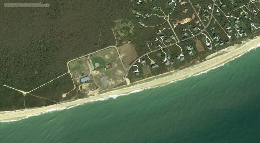
Today’s Agenda

• Downtown, Madaket, Nantucket Harbor &
  Coatue Draft Resilience Strategies Follow
  Up
   • Questions and Discussion (30 mins)

• Draft Island-Wide Recommendations
   • Erosion Management (40 mins)
   • Property Owner Guidance (25 mins)
   • By-Laws & Governance (25 mins)

                                              23 August 2021   2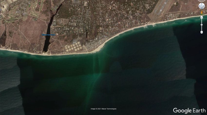
Nantucket’s Coastal                                   Changes to Zoning

Resilience Framework   Areas for Reduced          Acquisitions & land swaps
                       Growth and Retreat
                                                Public education & awareness

                                                 Public education & guidance
                       Areas for adaption of
                       existing buildings and         Changes to zoning
                           infrastructure
                                                 Capital investment & planning
    Nantucket's
      Existing           Areas to protect         Engineered flood protection
     Conditions        through engineering
     and Future             and design
    Risk Context                                     Erosion management

                       Areas for ecological         Nature-based solutions
                         restoration and
                          enhancement
                                                Enhancement of natural systems

                       Areas where ongoing          Modeling and analysis
                       study and planning is
                              needed
                                                  Planning and engagement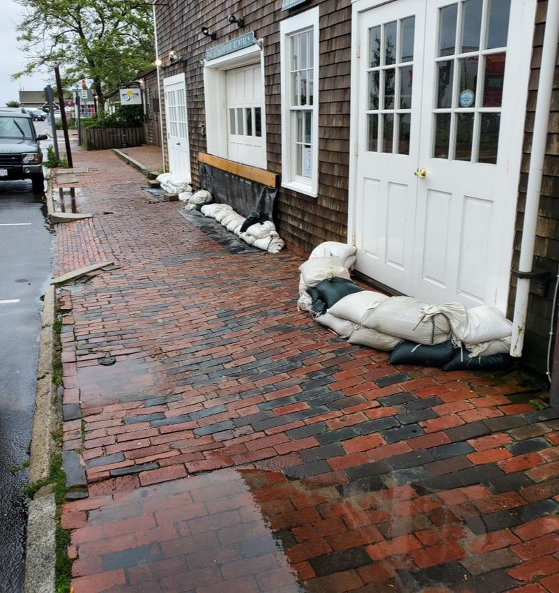
Erosion Management

                23 August 2021   7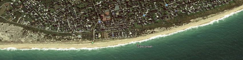
Erosion Management Priority
                                                                                                                                                        Erosion
    Areas                                                                                                                                            Management
                                                                                                                                                    Practices Based
                                                                                                                                                    on Priority Areas

                      Erosion
                   Management
                  Practices Based
                  on Priority Areas                                                          Coatue

                                                                 North Side

                                                                                                                                                                                  Erosion
                                                                                                                                                                               Management
                                                                                                                                                                    Codfish
                                                                                                                                                                              Practices Based
                         Madaket                                                                                                                                     Park
                                                                                                                                                                              on Priority Areas
                        Harbor Pilot

                                     Madaket
                                  Road/Ames Ave
                                       Pilot

                                                  Erosion Management Practices                   Airport                         Tom Nevers Field
                                                                                 Surfside WWTP
Draft for Discussion Only                            Based on Priority Areas

                                                                                                      Erosion Management Practices Based on Priority Areas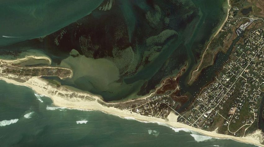
Erosion Management Approach
Evaluation Considerations
Near-term erosion management approaches preferences based on the criteria
below, following stakeholder input
  • Nature-based approaches that work with nature
  • Approaches that can be permitted today
  • Slowing or managing natural processes rather than stopping them
  • Prioritizing management of risk for critical infrastructure
  • Pilot projects that provide testing ground for ideas and enable evaluation
  • Community education, capacity building, and engagement

Pilot and urgent projects can move forward in the near-term, but development
of a sediment management plan and dredge plan should precede larger
investments in erosion management
Draft for Discussion Only                                                        8/23/2021   9
Madaket
    Strategy Objective: Reinforce beach and spit to reduce            Risk Category:
    potential for breach with impacts to Madaket Harbor and           Critical Infrastructure: 50-year/100-year event
    reduce risk to Ames Avenue bridge and Ames
    Ave/Madaket Road                                                  Near-Term Approaches (2020-2030):
                                                                      • Pilot projects including dune restoration/construction to reduce risk
    Existing Shoreline Type                                              of repeated breach and erosion
    • Low lying vegetated dunes with elongated spit                   • Sediment placement
    • Direction of sediment transport is likely westward                   • Potential to mine relic flood shoals immediately north of
    • May be able to estimate change through time by                           barrier
       examining the morphology of the distal lobe                    • Understand renourishment interval based on pilot project
                                                                      • Sand Fencing

                                                                      Longer-term Approaches (2030-2100):
                                                                      • Relocation/retreat of existing development and infrastructure over
                                                                         time
                                                                      • Adaptive reuse as recreation/open space/ and ecological
                                                                         restoration

                                                                      Opportunities for Community Engagement and Education:
                                                                      • Plantings
                                                                      • Crowd-sourced monitoring

                                                              © Arcadis 2021                                             23 August 2021   10
Draft for Discussion Only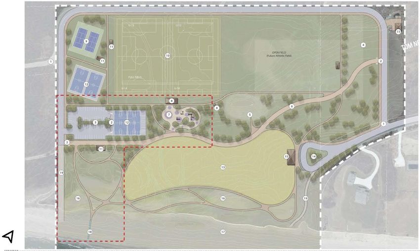
Madaket

                            Relic overwash fan:
                            Potential source of
                             borrow material

Draft for Discussion Only
Dune Restoration Approaches:
Typical Cross Sections
Reinforced Dune Profile Naturalized Dune Profile
Natural Dune Potential Configuration
Cobble Berm and Artificial Dune, Cape Lookout State
Park, Oregon (Komar, 2010) Northeast Ocean Council, 2021
Sediment Sourcing Considerations:
Storm overwash fans may be a viable source of material for Draft for Discussion Only
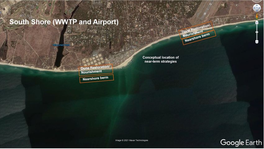
dune construction (Bay side of Madaket)South Shore (WWTP and Airport)
Strategy Objective: Reduce risk to critical infrastructure from erosion due Risk Category:
to storms Critical infrastructure: 100-year event
Shoreline Type: Near-Term Approaches (2020-2030):
• Low lying vegetated dunes • Dune restoration/construction to reduce risk of erosion. Hard
• Fronting nearshore bars with adjacent accretionary feature indicating core dunes may be appropriate given critical infrastructure
sediment deposition • Sediment placement
• Either direct or nearshore berm/sand engine
Considerations:
• Approaches will incorporate sediment transport direction and temporal Longer Term Approaches (2030-2100):
changes in direction if any • Relocation of settling tanks inland
• This location likely impacts downdrift areas of concern such as Madaket • Relocation of airport infrastructure inland
and should be addressed with this connectedness in mind
Opportunities for Community Engagement and Education:
• Plantings
• Crowd sourced monitoring
Draft for Discussion OnlySouth Shore (WWTP and Airport)
Conceptual location of
near-term strategies
Draft for Discussion OnlyTom Nevers
Strategy Objective: Near-term pilot program of restored vegetative Risk Category:
dune, sand fencing, and beach nourishment. Monitoring how well Non-critical infrastructure: 50-year event
the pilot project performs will inform future investment like the
proposed park facilities, as well as erosion management elsewhere Near-Term Approaches (2020-2030):
on the island. • Dune restoration/construction to increase elevation
• Sediment placement
Shoreline Type: • Either direct or nearshore berm
• Medium to low-lying vegetated dunes • Sand Fencing
• Well-developed fronting nearshore bars • Potential reconsideration of park design based on erosion
management performance
Considerations:
• Protect dunes from foot and other traffic via beach access from Longer Term Approaches (2030-2100):
park that preserves dunes and provides opportunities for • Maintenance and monitoring of nature based erosion management
community education. • Relocation of park facilities
Opportunities for Community Engagement and Education:
• CoastSnap: Crowd source beach monitoring (SeaGrant)
• Surf Camera at Park
• Will need local support for this
• Can look at beach conditions before traveling to site
• SandSnap
• Dune Plantings
Draft for Discussion OnlyParks and Recreation Master Plan – Tom Nevers Park
Proposed Park Redesign with Erosion Hazard Areas
Draft for Discussion Only
8/23/2021 19Tom Nevers Draft for Discussion Only
Community Engagement and Citizen
Science Opportunities
CoastSnap relies on repeat photos at the same
location to track how the coast is changing over time
due to processes such as storms, rising sea levels,
human activities, and other factors.

Photogrammetry enables the position of the
coastline to be pinpointed from your snaps to an
accuracy similar to that of professional coastal
survey teams.

Monitor beach and dune system behavior over time
which can help support scientist and engineers’
systems understanding and thereby enable informed
management decisions.

Draft for Discussion Only
https://www.wrl.unsw.edu.au/news/becoming-a-beach-scientist-is-as-easy-as-slip-stop-snap
https://www.deseagrant.org/coastsnap
Draft for Discussion Only

Public Access
Beach Front Access

The proposed meandering pathways through the dune system
represent a risk to the viability and health of the dunes due to human
impacts. An alterative approach for providing public access is via an
elevated walkway that enables access to the beach but helps maintain
the integrity of the dunes. Such access points can include installations
that help inform the public about sea level rise and the pilot project.

   Example of a vegetated dune                                             Example of elevated walkway over vegetated dune

© Arcadis 2020                                                                                      23 August 2021       22
Codfish Park / Sconset Bluff
Strategy Objective: For Codfish Park, protect and restore                 Risk Category:
continuous dune system to manage erosion risk and reduce risk of          Non-critical infrastructure: 50-year event
flooding, while preserving public access over the dune.
                                                                          Near-Term Approaches (2030-2030):
For Sconset bluff, slow or prevent erosion with measures at base of       • For Codfish Park, dune restoration/construction with vegetation to
bluff while planning for relocation of structures and infrastructure on      increase elevation to reduce risk of coastal flooding through
top of bluff (dealt with in more detail through the Baxter Road study)       continuous dune system

Shoreline Type:                                                           •   For bluff:
• Transition from vegetated dunes at Codfish Park to coastal bluff              • Alt 1: Dune construction (sand-only) with vegetation
   along Sconset                                                                • Alt 2: Toe protection (either hard or nature fiber depending
                                                                                    desired level of protection and wave climate) with sediment
Considerations:                                                                     placement through direct nourishment or nearshore berm
• Focus here should be on near-term toe protection to prevent                   • Homeowner best management practices for bluff top
  collapse of bluff that may occur episodically during intense                  • Strategies along Baxter Road forthcoming through Baxter
  storms                                                                            Road Study
• Consider providing beach access over a continuous vegetated
  dune system                                                             Longer-Term Approaches (2030-2100):
                                                                          • Relocation/retreat of existing development and infrastructure over
 Draft for Discussion Only                                                   time
Codfish Park / Sconset Bluff
Toe Protection and Nourishment
Dune Restoration/ Nourishment
Draft for Discussion OnlyCoatue
Risk Category:
Strategy Objective: Reinforce narrow low-lying sections of barrier
Non-critical infrastructure: 50-year event
island to prevent washover/breaching into the harbor. Develop detailed
modeling study to understand the likelihood and consequences of
Near-Term Approaches (2020-2030):
breaching for the Harbor and surrounding communities
• Combination of dune restoration/construction with vegetation to
increase elevation at critical points
Shoreline Type:
• Sediment placement
• Barrier island fronting elongated lagoon/harbor
• Either direct or nearshore berm
• Sand fencing
Opportunity to use novel survey techniques through strategic
• Modeling study to evaluate impacts of breaching
partnership:
• Survey techniques combine low-cost high accuracy instrumentation
Longer Term Approaches (2030-2100):
available in market to move towards a more comprehensive
• Consider feasibility of weir pumping system near east and west
monitoring effort
Jetty to move sediment from channel to down drift beaches
• AUV/ROV kayak system
• Lidar enabled drone with hyperspectral imagery
Opportunities for Community Engagement and Education:
• Map seagrass habitat
• Plantings
• Potential to include water quality data (Salinity, temperature, DO)
• Add oyster shell bags
• CoastSnap/Sand Snap (sediments)
Draft for Discussion OnlyCoatue Draft for Discussion Only Potential Sand Bypassing
North Shore
Jetties to Eel Point
Strategy Objective: Support comprehensive sediment management   Risk Category:
approach from north jetty to distal end of shoreline            Non-critical infrastructure: 50-year event

Shoreline Type:                                                 Near-Term Approaches (2020-2030):
• Combination of low-lying vegetated dunes and bluffs           • Dune restoration/construction to increase elevation
• Complex nearshore bar/bottom topography                       • Sediment placement
• Variety of isolated shore protection projects                      • Either direct or nearshore berm
                                                                • Sand Bypass Pumping
                                                                • Sand Fencing
                                                                     • Learn more about its prior use and performance on this shore
                                                                • Generate database of existing shore protection projects (sand
                                                                   fencing, groins, etc) and their history

                                                                Longer Term Approaches (2030-2100):
                                                                • Relocation/retreat of existing development and infrastructure over
                                                                   time

Draft for Discussion Only
Draft for Discussion Only
Potential Sand
Sand Placement or Nearshore berms Bypassing
Potential
source of
borrow
material
8/23/2021 28Private Property Owner
Guidance
23 August 2021Private Property Owners Play a Critical
Role in Resilience
Madaket
30Private Property Owners Play a Critical
Role in Resilience
Madaket Road
31Private Property Owners Play a Critical
Role in Resilience
Folgers Marsh
32Ultimately, we want property owners to TAKE
ACTION to reduce flood risk to their property
Rain Garden Permeable Pavement Elevate Structures Relocate Structures
Draft for Discussion Only
23 August 2021 33• What kind of information do property owners
need to take action?
• How should this information be organized?
• How should this information be shared?
Draft for Discussion Only
23 August 2021 34What kind of information do property owners
need to take action?
• What are the options?
• Scale
• Level of Effort
• How can they reduce my risk?
• Which options are cheaper or more expensive?
• Where should I start?
Draft for Discussion Only
23 August 2021 35How should this information be organized?
Draft for Discussion Only
More Difficult
• The best way to protect a private
property depends on several factors:
Higher
Ease of Implementation
• Type of flooding/erosion Cost
• Type of property
• Risk tolerance
• Priorities Moderate
Cost
• Resources
• Historic Considerations
Lower
Cost
• Easy Wins
Easier
Easy
• Actions all property owners should
Wins
take
• Lower Cost Lower Higher
• Moderate Cost Cost
• Higher Cost
23 August 2021 36Easy Wins to Reduce Risk Today
• There are a lot of options when it comes to
mitigation
• It can be hard for property owners to know
where to start
• Checklist of 5 high priority ways to reduce flood
& erosion risk at nearly all properties with
relatively few resources
❑ Know your risk today and in the future
❑ Purchase and maintain flood insurance
❑ Prepare
❑ Install a backflow valve and/or sump pump
❑ Protect your windows and doors
Draft for Discussion Only 23 August 2021 37Deployable Barriers • “just-in-time” measures • active systems with multiple possible failure points Draft for Discussion Only 23 August 2021 38
Resilience is NOT One Size Fits All
Draft for Discussion Only
• Building resilience at each property will require a
   unique combination of lower, moderate, and higher
   cost activities
• Lower cost options do not necessarily need to be
   implemented before moderate or higher
• There are many factors to consider before
   determining the appropriate resilience approach at
   a specific property:
     • Type of flooding/erosion
     • Type of property
     • Risk tolerance
     • Priorities                                       Elevate Utilities   Relocate Structures
     • Resources
     • Historic Considerations
• Successful resilience approaches will likely change
   and adapt over time                                                           23 August 2021   39
Lower Cost Options Draft for Discussion Only
• Elevate appliances and utilities
• Seal foundation and basement walls
• Use flood-resistant building materials
• Install flood vents
Elevate Utilities Seal Foundation Install Flood Vents
23 August 2021 40Moderate Cost Options Draft for Discussion Only • Reduce impervious surfaces • Raise first floor level • Fill basement • Anchor home Permeable Pavement Rain Garden Fill Basement23 August 2021 41
Higher Cost Options                         Draft for Discussion Only

• Elevate property
• Relocate home

 Elevate Structures   Relocate Structures   Land Acquisition
                                                       23 August 2021   42
New shutters should be
appropriately sized to cover the
window opening and should be
Historic Considerations in a historical style appropriate
for Nantucket. The addition of
storm windows and doors is
• Consistent with Resilient Nantucket: encouraged to protect historic
Flooding Adaptation & Building materials.
Elevation Design Guidelines
• Call outs throughout to indicate
considerations for historic properties
Utilities mounted on the
exterior of a historic building
should not be readily visible
from the street or public right-
of-ways and should be
screened with appropriate
landscaping to remain
consistent with Nantucket’s Draft for Discussion Only
traditional designs. 23 August 2021 43How should this information be shared?
• Full property owner guidance
document to be included in
final report
• Condensed, plain-language
and visual version will be
developed for distribution to
homeowners
• Mailer or Utility Insert
• Brochure
• Fact Sheet
Draft for Discussion Only 23 August 2021 44Ongoing Conversation and Support
• This property owner guidance is the first step
in an ongoing and evolving conversation
• Property owners will need long-term support
from a network of Town, State (CZM, EEA,
etc.) and Federal (FEMA) resources to build
resilience
• CRAC will play a critical role in sharing
information and guiding homeowners
Draft for Discussion Only
23 August 2021 45Governance & By-Laws
23 August 2021The Governance Context
Federal
• Federal Emergency Management Agency
• Floodplain mapping and NFIP • U.S. Army Corp of Engineers
Federal • Grants/Funding
• National legislation and standards
• Environmental Protection Agency
• National Park Service
Massachusetts
• Massachusetts Emergency • Office of Coastal Zone
• Grants/Funding Management Agency Management
• Enabling legislation and minimum •
State standards (e.g., wetlands & zoning)
• Building code
• Mass Department of
Environmental Protection
Department of Conservation
and Recreation
• Board of Building Regulation • Office of Energy &
and Standards Environmental Affairs
• Zoning Nantucket
• Wetlands • Historic Districts Commission
• Select Board
•
Local •
Capital planning
Process and Organization • Conservation Commission • Steamship Authority Governing
Board
• Town Meeting • Natural Resources
• Department of Public Works
• Planning Board
• Water & Sewer Departments
• Zoning Board of Appeals
• PLUS
Draft for Discussion Only 23 August 2021 47The Governance Context
Town has ability to alter local
by-laws, regulations, and
processes but only as permitted • Floodplain mapping and NFIP
by State and Federal law Federal • Grants/Funding
• National legislation and standards
• Grants/Funding
• Enabling legislation and minimum
State standards (e.g., wetlands & zoning)
• Building code
• Zoning
• Wetlands
•
Local •
Capital planning
Process and Organization
• Town Meeting
Draft for Discussion Only 23 August 2021 48Considerations • Any new or revised by-laws or regulations or procedural changes must be legal under State and Federal law • Nantucket Town Meeting will need to pass new or revised by-laws so they must have community support • People need to understand the rationale for and requirements of any new or revised by- laws and regulations • New or revised by-laws and regulations must minimize administrative burden or come with additional resources and capacity for administration • New or revised by-laws and regulations must be enforceable Draft for Discussion Only 23 August 2021 50
Zoning
What can zoning do and how has it been
used in other communities?
• Zoning controls the density, dimensions,
  location, and use of development
• Zoning can influence what people build
  and where but has little control of
  structures already in place
• Communities are beginning to integrate
  coastal resilience into local zoning
  codes to advance resilient design and
  manage land use in the floodplain
Draft for Discussion Only                    23 August 2021   51
Wetlands
Draft for Discussion Only

What can wetlands regulations do and how
have they been used in other communities?
• Local wetlands ordinance / regulations
  protect natural areas and their buffers
  from encroachment and impacts
• Wetland regulations can ensure buildings
  and infrastructure are located to minimize
  impacts to natural resources, like filling
• Some communities are beginning to
  integrate coastal resilience into local
  wetlands regulations to account for SLR
  and enable resilient design
                                               23 August 2021   52
Goals for Nantucket To help advance long-term coastal resilience on Nantucket by helping: Goal 1: shape land-use and development Goal 2: limit the potential for future regulations that seek to encourage home- and densification in areas that are at extreme business-owners, as well as the Town, to coastal risk, unsafe for human occupation, implement appropriate resilience measures have sensitive natural resources, and/or are and design on their properties in coastal not suited for future infrastructure investment hazard areas Draft for Discussion Only 23 August 2021 53
Zoning Recommendations for Resilient
Development in Moderate Risk Areas
    Draft for Discussion Only

•        Update existing Flood Hazard Overlay District (139-12 FHOD) with provision of
         Massachusetts 2020 model floodplain by-law                                                       Must do action

•        Limit construction of Essential/Critical Facilities and High-Risk Structures in areas of high-
         moderate coastal hazard
                                                                                                          Low hanging fruit
•        Exclude flood protection elements, required access to elevated buildings, and structures
         for elevated mechanicals, and other resilience measures, from gross floor area and lot
         coverage calculations

•        Establish recommended or required DFE based on a selected SLR increment above the
         identified FEMA BFE. This DFE represents new minimum for lowest occupiable floor and
         critical MEP systems for residential uses or flood proofing for non-residential structures.
                                                                                                          Complex but high
•        Expand Flood Hazard Overlay District to include future floodplain including SLR                  resilience benefit
     •      Reference to 500-year floodplain on existing FIRMs or by adopting local “Best Available
            Flood Hazard Data”
                                                                                                             23 August 2021   54
Zoning Recommendations for Resilient
Development in Extreme and High Risk Areas
Draft for Discussion Only
• Establish protocol for PLUS staff and Planning Board review of development proposals
within areas of Extreme and High Coastal Hazard for consistency with long-term planning Must do action
goals of reduced density and development
• Additional Actions to Limit Future Density
• Limit residential density to single family detached dwellings, with no permitted
secondary, tertiary, or accessory dwelling units
• Limit lot coverage to 40,000
resilience benefit
sf)
• There are multiple ways these limits could be implemented, including a new overlay district,
mapping of existing lower-density districts with special permit requirements, or by
extending the existing island perimeter restrictions
Additional outreach will be necessary before advancing the above options
23 August 2021 55Wetlands Regulations Recommendations
Draft for Discussion Only
• Establish Climate Change and Coastal Resilience as an interest and purpose of the wetland
regulations
• Establish new jurisdictional area including areas adjacent to Land Subject to Coastal Storm
Flowage to include areas subject to future coastal storm flowage with performance standards
intended to minimize changes to natural floodplains and ensure resilient development and Low
Impact Design
• Establish waiver provisions to enable permitting of coastal resilience projects that meet certain
criteria:
• Provide an overwhelming long-term public benefit in the form of coastal risk reduction and
public access
• Are deemed necessary based on an exhaustive alternatives analysis
• Impacts can be mitigated on or off site
• Maximize use of nature-based approaches and materials that provide ecological benefits
Additional outreach will be necessary before advancing the above options
23 August 2021 56Governance • Ensure effective management of high importance projects
and initiatives related to coastal resilience and
sustainability
• Create opportunities for communication and collaboration
What are we • Establish a formal, predictable structure for Town staff and
trying to leadership to meet and discuss issues related to long-term
coastal resilience, sustainability, and adaptation
accomplish?
• Facilitate coordinated decision-making by Town staff on
issues related to coastal resilience and sustainability
• Enable sharing of resources and knowledge around key
issues related to long-term coastal resilience, sustainability,
and adaptation between Town staff
Draft for Discussion Only
23 August 2021 57Governance Recommendations
• (Re)establish and formalize an interdepartmental working group
chaired by the Assistant Town Manager for Strategic Projects and/or
Special Projects Manager and including all relevant Town
Departments focused on coastal resilience and sustainability issues
• Establish a framework for joint staff review of development
proposals
• Transition to a Coastal Resilience Program model that builds on the
CRP with a framework for ongoing planning, funding, and
implementation of coastal resilience projects
Draft for Discussion Only
23 August 2021 58Resilience Program Model
Draft for Discussion Only
Objective: Establish a sustainable programmatic model for maintaining, funding,
and implementing the Coastal Resilience Plan and other related efforts
Roles and Responsibilities: Organizational Details
• Program led by Coastal Resilience
• Develop and maintain a tracking system for all flood resilience projects including location, Coordinator (Natural Resources Department)
implementation timelines, project status, and project needs with support staff
• Develop and maintain a funding database to identify and track local, state, and federal • Participation and input by relevant technical
funding opportunities for applicable projects staff form appropriate Town departments
• May necessitate need for additional IT
• Develop 1-, 3-, and 5 – year funding strategies for coastal resilience and sustainability capabilities for mapping and tracking of
projects. Fund projects by working with Town staff to develop funding and finance projects
applications to State, Federal, and private entities, as well as local budget requests
• May necessitate need for additional staff
• Lead updates to key coastal resilience and sustainability plans, including the Coastal training and capacity
Resilience Plan • CRAC plays key advisory role on program
• Lead or coordinate with community and stakeholder engagement around key coastal
resilience plans, policies, and initiatives
• Establish and maintain strategic partnerships with private and public entities
• Maintain regular touchpoints with related staff and functions, in coordination with the
Interdepartmental Working Group
23 August 2021 59Additional Feedback?
Send an email with any comments or
questions to
Nantucket.CRP@arcadis.com
23 August 2021 60Where are we in the process?
December January
October November February March April May June July August September
2020 2021
Project Kickoff & Data Collection
Coastal Risk Assessment
Mid-Project Report
Coastal Resilience & Adaption
Strategy Development
Implementation Planning
We are here
Open House 1 Community Engagement Open House 2
Final CRP Project Implementation
23 August 2021 61Thank you!
23 August 2021You can also read