MOJAVE LIMESTONE by Jerry Handren
←
→
Page content transcription
If your browser does not render page correctly, please read the page content below
MOJAVE
LIMESTONE

by Jerry Handren
© 2021 by Jerry Handren. All rights reserved.
No part of this book may be reproduced in any form without permission in writing from the author.
ISBN - 978-1-7923-4959-1
Printed in China.

Warning! Read before using this book.

Climbing is an extremely dangerous activity. Always use judgement rather than the
opinions represented in this book. The author assumes no responsibility for injury or
death resulting from the use of this book. The information in this book is based on
opinions gathered from a variety of sources. Do not rely solely on the information,
descriptions or difficulty ratings as these are entirely subjective. If you are unwilling to
assume complete responsibility for your safety, do not use this book.

The author and publisher expressly disclaim all representations and warranties
regarding this guide, the accuracy of the information herein, and the results of your
use hereof, including without limitation, implied warranties of merchantability and
fitness for a particular purpose. The user assumes all risk associated with the use of
this guide.
RAINBOW N
Introduction . . . . . . . . . . . 4 Lone Mountain . . . . . . . 104 CANYON NEVADA
Clark Mountain . . . . . . . . 12 Urban Crag . . . . . . . . . . . . . . 106 BEAVER DAM
1st Tier . . . . . . . . . . . . . . . . . . 14 Cheap Bear Crag . . . . . . . . . . 108 MOUNTAINS 18
Elgin 15 miles
2nd Tier . . . . . . . . . . . . . . . . . 16 Suburban Crag . . . . . . . . . . . 110 (ghost town)
3rd Tier . . . . . . . . . . . . . . . . . 20 Ghetto Wall . . . . . . . . . . . . . . 113
15
Bailey Road Crag . . . . . . . . . . 27 La Madre East . . . . . . . . 115
Mt Potosi . . . . . . . . . . . . . 31 The Gun Club . . . . . . . . . . . . .115 WELCOME
SPRINGS AREA
Sleepy Hollow . . . . . . . . . . . . 33 Cactus Wall . . . . . . . . . . . . . .120
Sin City . . . . . . . . . . . . . . . . .121 Saint George
Two Tier Cliff . . . . . . . . . . . . . . 34
The High Cliff . . . . . . . . . . . . . 46 Rodeo Wall . . . . . . . . . . . . . . 122 UTAH
Story Crags . . . . . . . . . . . . . . 48 La Madre Central . . . . . . 124 91
Comedy Area . . . . . . . . . . . . .58 Waterworld . . . . . . . . . . . . . . 126
Comedy Crag . . . . . . . . . . . . . 59 Trenchtown . . . . . . . . . . . . . .130 DAVIDSON PEAK THE UTAH HILLS
Comedy Central . . . . . . . . . . . 61 Fire Wall . . . . . . . . . . . . . . . .142 WOODBURY ARIZONA
Woody Wall . . . . . . . . . . . . . . .64 La Madre North . . . . . . . 144 ROAD AREA
Cuzkotopia . . . . . . . . . . . . . . . 68 Dreamland . . . . . . . . . . . . . . 145 93 Beaver Dam VIRGIN RIVER
Cactus Joes. . . . . . . . . . . . . . .72 Peoples’ Wall . . . . . . . . . . . . .146 GORGE
Clear Light Canyon . . . . . . . . 76 Sheeples’ Wall . . . . . . . . . . . . 148 Mesquite
Buena Vista . . . . . . . . . . . . . . 77 The Black Wall . . . . . . . . . . . .149 168
Clear Light Cave . . . . . . . . . . . 80 The Grasshouse . . . . . . . . . . 150
The Porcelain Wall . . . . . . . . . . 88 Area 51 . . . . . . . . . . . . . . . . .152 Mount Charleston . . . . . . . . . . . . 157 The Grail . . . . . . . . . . . . . . . . . . . 320
Blue Diamond Cave . . . . . 92 Glendale
The Test Site . . . . . . . . . . . . . 154 Kyle Canyon . . . . . . . . . . . . . . . . . . . . 158 The South Wall . . . . . . . . . . . . . . . . . . 325
The Promised Land . . . . . 98 Pirates Cove . . . . . . . . . . . . . . . . . . . . .160 The Alcove . . . . . . . . . . . . . . . . . . . . . .332
ARROW CANYON
Blue Sky Bluff . . . . . . . . . . . . . . . . . . . . 162 The Back Wall . . . . . . . . . . . . . . . . . . . .334
Convenience Crag . . . . . . . . . . . . . . . . 165 Redbud Canyon . . . . . . . . . . . . . . . . . . 334
The Hood . . . . . . . . . . . . . . . . . . . . . . .165 Sacred Trust Wall . . . . . . . . . . . . . . . . . 342
SUN CITY The Balcony . . . . . . . . . . . . . . . . . . . . . 182 Sun City . . . . . . . . . . . . . . . . . . . .345
95 15
THE GRAIL
Nueva Esparanza . . . . . . . . . . . . . . . . . 186 Virgin River Gorge . . . . . . . . . . . 352
Mary Jane Cliff . . . . . . . . . . . . . . . . . . . . 188 The Paradigm Wall . . . . . . . . . . . . . . . . 355
White Pine . . . . . . . . . . . . . . . . . . . . . 190 The Mentor Cave . . . . . . . . . . . . . . . . . . 356
Yellow Pine . . . . . . . . . . . . . . . . . . . . . .192 Warm Up Wall . . . . . . . . . . . . . . . . . . . .359
X CAVE
Walla Walla Wash . . . . . . . . . . . . . . . . . 193 Blasphemy Wall . . . . . . . . . . . . . . . . . . 360
LA MADRE NORTH Universal Wall . . . . . . . . . . . . . . . . . . . .194 Grey Pillar . . . . . . . . . . . . . . . . . . . . . . 362
Imagination Wall . . . . . . . . . . . . . . . . . . 204 The Sun Cave . . . . . . . . . . . . . . . . . . . .364
Cathedral Rock . . . . . . . . . . . . . . . . . . . 214 The Sun Wall . . . . . . . . . . . . . . . . . . . . .364
MOUNT CHARLESTON 215
The Chert Locker . . . . . . . . . . . . . . . . . .220 Money Walls . . . . . . . . . . . . . . . . . 367
157 Sonar Wall . . . . . . . . . . . . . . . . . . . . . . 223
Las Vegas Woodbury Road Area . . . . . . . . . 371
The Palantine Wall . . . . . . . . . . . . . . . . .228
LA MADRE The Solstice . . . . . . . . . . . . . . . . . . . . . 371
CENTRAL The Dark Tower . . . . . . . . . . . . . . . . . . . 234
Black And Tan . . . . . . . . . . . . . . . . . . . .374
Route 158 . . . . . . . . . . . . . . . . . . . . . . 236
Kelly's Rock . . . . . . . . . . . . . . . . . . . . . 381
LONE MOUNTAIN The Clubhouse . . . . . . . . . . . . . . . . . . .238
THE PROMISED LA MADRE EAST
Mom’s Cave . . . . . . . . . . . . . . . . . . . . .240 The Utah Hills . . . . . . . . . . . . . . . .386
NE
LAND
Starter Crag . . . . . . . . . . . . . . . . . . . . . 240 Simian Complex . . . . . . . . . . . . . . . . . . 388
VA
The Treehouse . . . . . . . . . . . . . . . . . . . 242 Gorilla Cliff. . . . . . . . . . . . . . . . . . . . . . .390
D
Cat Eye Crag . . . . . . . . . . . . . . . . . . . . .242 The Snakepit . . . . . . . . . . . . . . . . . . . . .394
A
160 Soul Asylum . . . . . . . . . . . . . . . . . . . . . 397
The Glasshouse . . . . . . . . . . . . . . . . . . 246
CA
The Observatory . . . . . . . . . . . . . . . . . . 248 Boy Wall . . . . . . . . . . . . . . . . . . . . . . . 406
93
LI
The Sunhouse . . . . . . . . . . . . . . . . . . . .250 JB's Crag . . . . . . . . . . . . . . . . . . . . . . .407
FO
Robbers’ Roost . . . . . . . . . . . . . . . . . . .255 The Diamond . . . . . . . . . . . . . . . . . . . . 408
RN
BLUE DIAMOND
CAVE The Icehouse . . . . . . . . . . . . . . . . . . . . 263 Warm Up Wall . . . . . . . . . . . . . . . . . . . . 416
IA
MOUNT POTOSI Route 93/Interstate 15 . . . . . . . . . 267 Welcome Springs . . . . . . . . . . . . 418
15 X Cave . . . . . . . . . . . . . . . . . . . . . . . . 269 Logan Crag . . . . . . . . . . . . . . . . . . . . . .419
Kona Cave . . . . . . . . . . . . . . . . . . . . . 272 Sumo Wall . . . . . . . . . . . . . . . . . . . . . . 420
Arrow Canyon . . . . . . . . . . . . . . . . . . .274 The Meat Market . . . . . . . . . . . . . . . . . . 423
Davidson Peak . . . . . . . . . . . . . . . . . . 286 The Cathedral . . . . . . . . . . . . . . . . . . . .428
Wall Of Misfortune . . . . . . . . . . . . . . . . .287 Wailing Wall . . . . . . . . . . . . . . . . . . . . . 430
Missionary Wall . . . . . . . . . . . . . . . . . . .294 Anti-Theme Wall . . . . . . . . . . . . . . . . . . 437
Brevity Wall . . . . . . . . . . . . . . . . . . . . . 296 Beaver Dam Mountains . . . . . . . . 441
Primm Sunset Alley . . . . . . . . . . . . . . . . . . . . . 443
The Ballin' Alley . . . . . . . . . . . . . . . . . . .298
Spanish Isles . . . . . . . . . . . . . . . . . . . . .299 Index . . . . . . . . . . . . . . . . . . . . . 452
CLARK MOUNTAIN
Rainbow Canyon . . . . . . . . . . . . . . . . 303 Graded List . . . . . . . . . . . . . . . 458
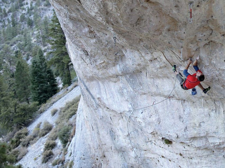
Steve Lapen on Hasta La Vista (5.14b/c)
Page 180.

  About this guidebook

   There is a spine of high limestone mountains running through the northeastern
   quadrant of the Mojave Desert, most of which are ringed with long cliff bands. This
   guidebook describes 2500 rock climbs found in and around these mountains. The
   area covered is based upon the cities of Las Vegas and Mesquite in Southern
   Nevada with some of the crags being in California, Southern Utah and Arizona.
   With the exception of Rainbow Canyon, where approximately half of the routes are
   traditional climbs, the routes covered in this guidebook are fully-bolted sport climbs.
   As a sport climbing venue this area has few peers anywhere in North America
   thanks to the year-long climbing season, the reliable weather, the low-hassle
   desert camping and above all the quantity, variety and quality of the routes.
   The areas most famous routes are iconic, nationally known test pieces such as
   Chris Sharma’s Jumbo Love on Clark Mountain, the gorgeous Golden For A Mo-
   ment and its maze of variations in The Cathedral, and the long, crimpy pucker-fests
   of the Virgin River Gorge. But more importantly for the vast majority of climbers,
   there is a real depth of quality climbing throughout the entire grade range. Also,
   perhaps more so than any other of North America’s premier sport climbing areas,
   the routes are extremely varied in almost every aspect. There are perfectly formed
   20' micro routes on Gorilla Cliff and brilliant eight pitch 5.14s on Universal Wall,
   there are routes of almost every grade, on rock of almost any angle, that use holds
   of every type imaginable.
   It seems likely that, as time goes by, the importance of this region as an epicenter
   for North American sport climbing will only increase. The amount of rock available
   and the pace of development are such that future editions of this guidebook will
   probably require two or even three volumes.
   Jerry Handren. December 2020.
6 INTRODUCTION INTRODUCTION 7
this book. Not only do the individual routes tend to have many quite common for blocky bits to suddenly become apparent in
The land, rules and regulations different types of hold which makes for really enjoyable, unpre- sections that had previously seemed solid. The bottom line is
Almost all the cliffs described in this guidebook are dictable, 3-D movement, but the different cliffs offer all types that you should climb cautiously when confronted with blocky
on public land. The two agencies responsible for of terrain from immaculate grey slabs to huge, drip-featured rock and be aware of the potential consequences for your
this land are the US Forest Service and the Bureau caves and everything in between. belayer and other climbers in the vicinity. If you are at the base
Of Land Management. However, there is a veritable The biggest drawback to this limestone is that it can be sharp, of the cliff it’s a good idea not to camp out inside the potential
smorgasbord of different designations within those sometimes razor sharp. In many situations it doesn’t take drop zone of someone who is climbing.
two jurisdictions, each with its own set of manage- much at all for the rock to chew through the sheath of a weight-
ed rope. It is important to be on the lookout for sharp edges, to Unlike the nearby sandstone of Red Rocks, Snow Canyon and
ment policies and rules.
pay attention to the path of the rope and to have strategies to Zion, limestone is only slightly weakened by being wet. Also,
The designation most relevant to climbers is help mitigate any potential issues. in general the rock tends to dry almost instantly after rain. This
"wilderness". Currently, no new bolting is allowed As well as being hard on the ropes, the rock can be hard on makes the cliffs described in this book a really useful alterna-
in wilderness areas; bolt replacement is permitted \RXU¿QJHUVNLQ7DSHFOLSSHUVD¿OHDQGVRPHW\SHRIQHZ tive to the sandstone areas after rain. Once the rock is visibly
but only with hand drills rather than power drills. VNLQJOXHWRKHOSSDWFKÀDSSHUVDUHHVVHQWLDOSDUWVRI\RXUGDLO\ dry it is reasonable to climb. The only caveat being that after
Many cliffs were bolted before the current rules climbing kit. In general, it’s best to slap on the tape as soon as long wet periods certain parts of some of the cliffs are prone to
were formulated and so there are quite a few cliffs a hold starts to chew your skin; worn skin recovers quickly but seepage which, once it has started, can linger for a while.
described in this book where the existing routes a hole that’s deep enough to bleed can take a while to repair. Overall, thanks to the superb rock and despite the negatives
are tolerated but new bolting is not allowed. To
Much of the rock is fantastically solid and reliable, but loose, mentioned above, this area provides some of the best sport
make this clear I mention where any cliff is known
blocky rock is also quite common and often not as easy to spot climbing in the USA as well as some of the most reliable year
to be in wilderness. Unfortunately, the wilderness
as you would like. Furthermore, in the author’s experience, it is round climbing conditions.
boundaries are not always perfectly obvious and so
some cliffs may be mislabeled; when in doubt the
best policy is to contact the local land management
for guidance.
%ROWVÀ[HGTXLFNGUDZVDQGDQFKRUKDUGZDUH
Fixed quickdraws in wilderness areas is an is- Limestone is not a rock that lends itself to natural protection, The American Safe Climbing Association helps provide a lot of
sue that hasn’t been fully dealt with yet, but it is and so almost all the routes described in this book are fully- the hardware that local organizations use for the upgrade and
probably tempting fate to have cliffs that are in bolted sport climbs. For better or worse, people who climb on maintenance of local climbing areas. If you are a rock climber
wilderness areas festooned with draws. In recent these routes are completely reliant on bolts for their safety. It is in the USA then this is an organization that deserves your sup-
years the managers of Arrow Canyon have asked outside the scope of this book to try and educate climbers on port. Donations can be made through the ASCA website; www.
WKDWDOO¿[HGGUDZVEHUHPRYHGIURPWKDWORFDWLRQ the ins and outs of bolt safety, but the bottom line is that bolts safeclimbing.org. The website is also a useful source of mate-
and it seems likely that this request will be repeated occasionally fail and that, as much as possible, climbers must rial for those who want to try and learn more about the details
elsewhere. try and avoid situations where their safety is entirely dependant of the placement and evaluation of bolts for rock climbing.
It is worth remembering that land management on a single bolt. It is worth any climber’s time to try and learn
agencies are capable of completely erasing a the basics of bolts so as to be able to recognize a suspect bolt.
climbing area. This is something that happened Report bad or suspect bolts to the Southern Nevada Climbers
in the Las Vegas area in the early 2000’s when Coalition for the areas around Las Vegas. For the areas
around 30 great routes were completely removed around Mesquite contact the Southern Utah Climbers Alliance.
from a cliff called the Shamen Cave in the Desert Mountain Project and Facebook are a good way to do that.
National Wildlife Refuge. The land managers sub- When reporting a bad bolt, it is very useful to the re-bolters if
sequently completely banned climbing anywhere you include a picture.
in the refuge, an action that was largely taken Climbers should have a small adjustable wrench in their pack
because they didn’t feel that climbers could be to snug-down loose bolts, but understand that it is vitally impor-
trusted to act responsibly. Climbers operating on tant not to overtighten as this can cause damage.
cliffs in the wilderness need to tread lightly or risk As well as the bolts themselves there is a certain amount of
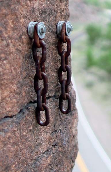
losing the privilege. ¿[HGKDUGZDUHRQDOPRVWDOOWKHFOLIIVWKURXJKRXWWKHUHJLRQ
Much of the rest of the BLM and Forest service land Most commonly, anchors have chains, carabiners and other
is open to climbing with few restrictions at present. hardware that is in place for convenient lowering from the top
One of the really nice aspects of this land is that of the routes. This hardware tends to wear out quite quickly
wild camping is also relatively unrestricted and and climbers should be prepared to check and evaluate all
often very pleasant. The only rules being to observe ¿[HGKDUGZDUHSULRUWRFRPPLWWLQJWRLW7KHVDPHLVWUXHRI
¿UHUHVWULFWLRQVOLPLWLQJVWD\VWRGD\VDQGWR ¿[HGTXLFNGUDZVZKLFKDUHEHFRPLQJLQFUHDVLQJO\FRPPRQRQ
pack out all trash. the most popular routes and sectors.
More localized rules, restrictions and guidelines are
Bird Of Prey. One of many excellent routes that were It is important to remember that all this equipment has been
erased from the Shamen Cave. placed ad hoc by a random assortment of climbers over many
dealt with in the introductions to the various regions
Photo: Dan McQuade. years. Although the Southern Nevada Climbers Coalition
and climbing zones.
and The Southern Utah Climbers Alliance do a fantastic job
The Rock of maintaining hardware in their respective areas, these are Unfortunately, there are still quite
volunteer organizations with nowhere near enough time a few of these dangerous relics
Although Southern Nevada is best known for the great escarp- the nicest aspects of this limestone from a sport climbers and resources to do this work in a complete way. It is every lurking around. This is one of many
ment of Red Rocks, Red Rocks is really just a tiny island of perspective is that it is a rock that offers incredible variety, and climbers individual responsibility to be able to evaluate the in Rainbow Canyon.
sandstone surrounded by a vast sea of limestone. One of that particular quality is especially true of the cliffs described in equipment that they are trusting their lives to.8 INTRODUCTION INTRODUCTION 9
Staying in the area Access
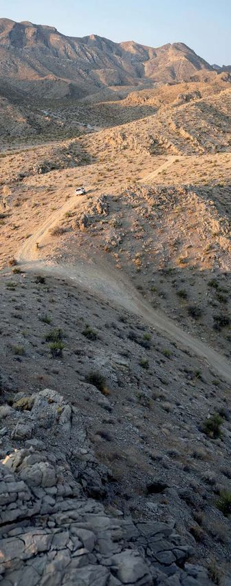
Transport and often get fully booked up. There are also a few pockets The entire area is served by Interstate 15 which
There is no public transportation system, so when visiting of forest service land on the mountain where wild camping is runs from Los Angeles in California to Salt Lake
the area a vehicle is essential. If renting a vehicle, it is worth allowed. City in Utah and beyond. In general driving from
considering spending the extra money for an SUV since quite one of the areas in this guidebook to another is
a few of the access drives are on dirt roads, some of which can Hotels and Air B&B are popular options for Las Vegas and
fast and easy, although it’s best to avoid rush hour
be quite rough. Gas stations are nonexistent throughout large Mesquite. In Mesquite especially, hotel rates are very reason-
in Las Vegas and driving to Clark Mountain on a
swathes of the region. It is a good idea to be conservative and able and this is certainly an option worth considering if the
Sunday afternoon.
WR¿OOXSZKHQ\RXFDQ weather really craps out.
One of the key factors with transportation in the
Camping and Accommodation Groceries
area is that access to the majority of the cliffs
The best way to enjoy the Mojave is to camp out in the desert. Las Vegas, Mesquite and Saint George have large grocery
involves driving on dirt roads. Many of these roads
For most of the region, other than the immediate Las Vegas stores, but most of the rest of the region is limited to a handful
are well-maintained to the point where you could
area, wild camping is relatively unrestricted and often very of gas-station convenience stores.
comfortably roll up to the crag in your lowrider.
SOHDVDQW7KHRQO\UXOHVEHLQJWRREVHUYH¿UHUHVWULFWLRQV &OLPELQJ(TXLSPHQW However some of the roads are very rough and
limiting stays to 14 days and to pack out all trash (this includes Desert Rock Sports at 8221 West Charleston Blvd. in Las require four wheel drive, decent clearance and a
toilet paper, burying is not an acceptable option). Vegas is a fully-stocked climbing store (702 254 1143), open bit of experience. The author drove to every cliff in
seven days a week. In Saint George there is The Desert Rat at this book multiple times with a Toyota 4-Runner,
Around Las Vegas camping options are more limited. Wild
468 West St. George Blvd. which is closed on Sundays (435 but he wasn’t always happy about it!
camping is not allowed anywhere in Clark County. The Red
Rock campground is an established campground near the 628 7277).
For each crag and area I have included a
entrance to the Red Rock Scenic loop road. It is open from Climbing Gyms paragraph about access which provides the basic
September to May, but is often fully booked. There is some There are four gyms in Las Vegas. Origin Climbing and information that you need to get to the point where
open forest service land in Lovell Canyon to the west of Red Fitness, The Red Rock Climbing Center, The Refuge and you have to start walking. What follows are a few
Rocks and also on the southwest side of Mount Potosi. Mount Southern Nevada Climbing Center. All four gyms also offer notes about how to use this information.
Charleston has seven established campgrounds that are open showers. At the time of writing a gym, "Contact Climbing" was
during the summer season, but again these are very popular Odometer readings
being built at 2865 E.850N. Street in St. George.
The mileage numbers used in the descriptions and
maps to indicate landmarks, turns etc. were read
Weather and Conditions from the author’s vehicle and can really only be
considered a rough guide. Different vehicles, tires,
road conditions etc. will knock these numbers off to
The cliffs described in this guidebook sit at a wide range of The almanac numbers for Las Vegas, which sits at an eleva- a certain extent.
elevations. At 2000', the Virgin River Gorge is the lowest, at tion of around 2000' are as follows. Average temperature 66.3
10,000' the Icehouse on Mount Charleston is the highest. As degrees (19 degrees centigrade). Average yearly rainfall 4.13 Road Conditions
a rule of thumb, the temperature goes down 50 F for every inches (10.64 centimeters). Average daily humidity 29 percent. I have usually tried to give an impression of what
1000' of elevation gain. What this means is that on any given 211.5 clear days annually, 82.4 partly cloudy days, 71.3 cloudy to expect on the dirt access roads. However, a
day throughout the year there are likely to be at least a few days. The numbers for Mesquite are almost identical. point to bear in mind is that all these roads are
cliffs where temperatures are perfect. Spring and fall are the always changing. All it takes is a big rainstorm to
seasons when you will have the most options, but summer and wash out a section of road and make what was
Month Average Average Sunny Days Average previously casual, impassable. It is very important
winter both have a lot to offer as well.
Daily Low Daily High Rainfall that you understand your own experience and the
This is the Mojave Desert, one of the drier places on earth.
(˚F) (˚F) (inches) capabilities of your vehicle and be prepared to
Although rain is not very common in general, the region is
sometimes subject to weather patterns that result in rainy January 33 56 24 0.5 retreat if the road looks too rough.
periods that can last for several weeks or longer. Almost all of February 37 67 22 0.46 Road Closures
the cliffs are composed of limestone which is very quick to dry,
Depending on the prevailing policies of the various
and only slightly weakened by moisture. The rock is therefore March 42 68 25 0.41
land management agencies, dirt access roads will
climbable shortly after the rain stops, just don’t climb on rock
April 49 77 26 0.22 sometimes close. This has especially been the
that is still visibly wet. Even during the rainiest spells it is usu-
case for a few of the areas close to Las Vegas
ally possible to eke out plenty of climbing. May 59 87 27 0.22 where driving on the traditional access routes is
Limestone cliffs are sometimes prone to seepage after longer
June 68 98 28 0.09 no longer allowed. Be prepared to turn back rather
periods of rain, this is particularly true at the higher elevation
than driving on roads that are closed.
areas if it has been a wet winter. Accumulations of slowly-melt- July 75 104 27 0.45
ing snow can keep some of these cliffs (particularly the cave Remoteness
August 73 101 26 0.54
sectors) seeping well into the spring and early summer. Most Aside from being rough, many of the access roads
years this problem is limited to a few individual routes on a few September 65 94 28 0.32 take you to very remote places where getting help
cliffs, but some years it can be more widespread. October 53 81 27 0.25 for a broken down vehicle is not even an option. A
I have included a paragraph with some basic information about charger kit in case of a dead battery is a sensible
conditions for each crag and/or area. This usually includes November 41 66 24 0.43 precaution. A functioning spare tire and knowing
information about elevation, sun versus shade, exposure December 33 67 24 0.32 how to change it is mandatory. Every vehicle
to wind, the range of workable temperatures and the best should carry emergency supplies such as extra
seasons to visit. water, food and warm clothing.10 INTRODUCTION INTRODUCTION 11
Grade Bolt Counts
Approaches The standard rating system is used: 5.0 to 5.15 with the grades The bolts counts are approximate and do not include the an-
from 5.10 up subdivided into a,b,c and d. This book covers chor. It’s always best to take at least a couple of extra draws.
For every cliff I include a paragraph which describes how to get useful to understand what the time is and isn’t. What it isn’t is
such a large area that there will certainly be variations in grad- Fixed draws have become quite common on many of the most
to the climbs from the end of the access roads. In most cases an exact measure of how long it will take you to get to a given
ing as you go through the different regions. In general I have SRSXODUVHFWRUVEXWWKHEROWFRXQWVGRQRWUHÀHFWWKHLUSUHV-
these approaches are on well established climbers trails that cliff. What it is is a measure of how long it takes the author to
tried to use classic routes with well-established grades as my ence or absence.
are easy to follow, but there are also a few places where the get to a given cliff, that means someone who knows the way
benchmarks, and where routes seem to fall well outside these
approach is more tricky and the descriptions correspondingly and whose pack is a little lighter than you would usually carry GPS
benchmarks I haven’t been shy about adjusting the grade.
more detailed. To help with this process I’ll often use approach IRUDGD\VFOLPELQJ0RVWZLOO¿QGWKDWWKH\WDNHDOLWWOHORQJHU A GPS is a useful tool when climbing in this area. Its correct
Having said all that, it’s not an exact science and there will no
maps and photographs to make things clearer. For most some a little shorter, but the good news is that that difference XVHYLUWXDOO\DVVXUHVWKDW\RX¶OO¿QG\RXULQWHQGHGFOLIIDQG
doubt be a wide assortment of gifts and sandbags in the mix.
approaches I include three key bits of information: Elevation will be somewhat consistent for different approaches. more importantly, your way back to the car and the main roads.
Furthermore there are numerous routes that have had very few
gain, distance and time. The elevation gain and the distance 7KHUHLVPRUHWKDQHQRXJKLQIRUPDWLRQLQWKLVERRNWR¿QG
ascents and for which there is no real consensus on grade.
are taken from GPS readings and should be quite accurate. It’s every cliff without using GPS; in fact one crusty local veteran
Star Rating once suggested that if you need a GPS to get there, then
This guidebook uses a three-star system to rate the quality of you probably shouldn’t be there. Nevertheless a GPS is very
Arrangement of this Guide
the routes. Obviously this is very subjective and these ratings useful. Just remember that no gizmo is a substitute for good
This guidebook is arranged as a series of regions, which are Each region is subdivided into a series of climbing zones which should be taken with a grain of salt. Certain personal biases no judgment, and understand that batteries get low and devices
described from south to north. A region often corresponds to a usually correspond to individual cliffs. Where these cliffs are doubt crept into the assessment. So, for the record, I should get lost, wet, and broken.
major geographic feature such as Clark Mountain or the Virgin close together they may all be covered in one approach map, say that clean rock, sweeping natural lines, and sustained In the text, I have included some basic GPS data for almost all
River Gorge, but really it is just a way of grouping a set of where the cliffs are more spread out, or the approaches more climbing are factors that will push a route up the scale. Poor of the cliffs. Generally, this includes key points on the access
climbing zones that have similar access. There are also a few complex there may be an approach map for each individual rock, dirt, a contrived line and ugly, heavy-handed manufactur- roads, the parking area, key points on the approach trail, and
FOLIIVVXFKDV7KH*UDLODQG3URPLVHG/DQGZKLFKGRQ¶W¿WLQ cliff. The individual cliffs may be subdivided into different ing will push a route down. where the approach trail hits the cliff. The GPS coordinates in
well with other crags and are treated as standalone regions. sectors, depending on how extensive the cliff is. Almost all the I have tried to be very conservative in doling out stars so that this book were collected on a Garmin Oregon 450 using the
Each region has an access overview map which shows the sectors in this book have a photodiagram which shows the the really good routes stand out; this is mostly to point visiting following formats:
main access roads and also the location of the different climb- approximate line of all the routes within that sector. In a few climbers at the very best routes. The fact that a route has no
stars does not mean that it is not worth doing; instead I have Datum: WGS 84.
ing zones within the region. There may also be more detailed cases where tree cover or a very narrow canyon has made
tried to mention in the text if a route is really poor quality. In Position Format: Lat/Lon hddd°mm.mmm'
access maps which show the access routes for different parts getting a good crag shot impossible I have used plan maps to
of a given region. show how the routes lay out. fact, one of the great things about Mojave limestone is that On the website www.mojavelimestone.com I have stored the
the overall quality of the routes is generally quite high. Another tracks that I recorded when doing the approach hikes. These
point worth mentioning is that to a certain extent I have used can be downloaded onto GPS devices and used to assist with
Route Descriptions single stars to indicate the better routes at the lower quality navigation.
cliffs, so that, for example, a one star route at one of the Lone
For most of the routes in this guidebook I have given detailed Symbols Mountain cliffs is probably not up to the quality of a one star www.mojavelimestone.com
descriptions. Since most of the routes are sport climbs where A sport climb. A route that is protected exclusively by route at one of the better crags such as The Grail. To submit new routes, corrections and updates visit www.
you just follow the bolts, the purpose of these descriptions is FORVHO\VSDFHGEROWVZLWKD¿[HGDQFKRUDWWKHWRS
First Ascent Details mojavelimestone.com. The website will also contain extra
not so much to keep a climber on route, it is to help identify the A traditional route that uses self placed gear for protection.
:KHUHSRVVLEOH,KDYHLQFOXGHGWKHQDPHVRIWKH¿UVWDVFHQW topos, photos etc. that didn’t make it into the book as well as
route. This is important because new routes are always getting
Route Names team, although there are many routes for which this informa- information on new developments.
added to these cliffs and if this is the case then simply counting
bolt lines from one side or the other of a sector won’t work. *HQHUDOO\WKHURXWHQDPHVDUHWKRVHJLYHQE\WKH¿UVWDVFHQW tion is not available.
party. However, there are many established routes and even
Route Route Route Quality whole cliffs where I wasn’t able to track down the correct route Maps
Number name length Route rating names. Rather than having numerous "Unknowns" I have 4200
taken the liberty of providing a name for every route in the
4400
53
grade
00
Red for First OVERVIEW MAPS
sport route Ascent guidebook. I apologize in advance to anyone whose route is
Details incorrectly named in this book. In future guidebook editions
2 Hyper Ultra Extra 90' 5.6 *** many route names will undoubtably change as the real names
Betsy Herbst, Joe Herbst. February 1972. come to light. Hopefully the confusion that this causes is the Dense
lesser of two evils. Routes that are currently un-redpointed 300 Vegetation Climbing Area
Start 20' right of the block/pinnacle. Climb shallow Big Grey 400 yards
5
runnels to intersect an orange left-leaning groove at 20'. are named "Project", and where there are several on a cliff Mountain
Follow the groove left to join Vortex at the base of the they can be numbered "Project 1", "Project 2" etc. I reserve 5000
Wash/Stream/Drainage
corner. Finish direct up wide runnels (4 b’s). the term "Unknown" for mystery bolt lines where I have no Summit/High Point Approximate Scale
Large boulder
bolt count information. 470 Established Hiking Trail
0 46
00
450
Length 0 Climbers Trail/Use Trail/
Route Number Route lengths are approximate. Getting lowered off the end Cross Country Route 100'
430 Band of rock with 440
0 Contours
Routes within a cliff or sector are assigned a route number. of the rope is one of the more common causes of accidents in no climbing
0
This number is used to identify the route on any photodia- sport climbing. Since many of the routes described in this book 4200 Dirt Road
grams or plan maps of that area. In most cases routes are are real rope-stretchers it is vitally important that climbers 20' Contours 430
Asphalt
0 Road
on the same page as their photodiagram. In certain sections, always put a stopper knot in the ends of their ropes. This Man-made Structure
where the route descriptions are spread over several pages, is especially true because many routes are long enough that
the photodiagram will always be within that section. If a route you can’t be lowered from the top anchor to the ground in one Rest Rooms Parking Area
doesn’t have a number then it is not shown in the photodia- go and instead the climber must lower to a mid-anchor, re- 41
00 4200
gram or plan map of that area. attach, pull the rope and be lowered a second time.You can also read