March 2022 Tennessee State Climate Summary
←
→
Page content transcription
If your browser does not render page correctly, please read the page content below

March 2022 Tennessee State Climate Summary

       March 2022 Tennessee State Climate Summary
                      Tennessee Climate Office * East Tennessee State University
                         Prepared by William Tollefson and Dr. Andrew Joyner
                  With contributions by Climate Data Representatives across the state

Monthly Temperature Summary:
The mean temperature for March 2022 was above average for most areas of Tennessee, with the majority
of the state running 2-4°F above the 1991-2020 30-year climate normals. Despite the above normal mean
temperatures, there were major swings in temperature during the month, which is common for
springtime in Tennessee. Temperatures recorded during the month ranged from -4°F at Mt LeConte (in
Great Smoky Mountains National Park) on March 13 to 85°F at Shiloh National Military Park (Hardin
County) on March 4 and at Tennessee Ridge (Houston County) on March 5.
Another sign of the wide range of temperatures for the month was that a large number of daily records
were set for both warm and cold temperatures during March. At stations with at least a 30-year reporting
history, there were 43 broken and 23 tied record-warm daily high temperatures. There were 26 broken
and 7 tied record-warm daily low temperatures. On the flip side, there were 15 broken and 5 tied record-
cold daily minimum temperatures, and 27 broken and 1 tied record-cold daily high temperatures. Mt
LeConte shattered its previous daily record-cold high temperature on March 13 with a high temperature
of just 9°F, 16 degrees colder than the previous record for the date set in 1998.

                                                                                                      1
March 2022 Tennessee State Climate Summary

Monthly Precipitation Summary:
Precipitation totals for March 2022 were below the 1991-2020 30-year climate normals for most of the
state, with the northeastern quadrant of the state being the driest, with most areas recording less than
75% of their normal March precipitation including some locations recording less than 40% of their normal
March precipitation. Some areas in northwest Tennessee, and southern counties in East and Middle
Tennessee did record above normal precipitation, with southeastern Lincoln County recording over 150%
of their normal March precipitation. Despite the drier than normal total precipitation, there were 15
weather stations that recorded daily records for highest precipitation during March 2022.
A large snowstorm impacted the state from March 11-12, generating the most significant March snowfall
in Tennessee since the blizzard of 1993. From Middle to East Tennessee there were widespread reports
of 2 to 5-inches of snow with higher amounts of around 7-inches locally. With this event, there were 31
broken and 2 tied daily records for daily snowfall totals, including 7 broken records at stations with at
least a 100-year reporting history. Of those records, 3 stations broke and 1 station tied their monthly
record for March snowfall; all of these snowfall records were measured on March 12.

                                                                                                       2
March 2022 Tennessee State Climate Summary

Station Data and Top Tenn. (warmest/wettest, coldest/driest stations of the month):
Station data for airports across the state using WBAN weather stations, compared to 1991-2020 30-year
climate normals for Departure from Mean Temperature and Total Precipitation:
                                            Temperatures (˚F)                                  Precipitation (inches)
 Station Name              Averages                               Extremes                             Totals
                Max      Min      Mean      Depart    High      Date      Low     Date       Obs       Depart    %Norm
   Memphis      66.7    43.7      55.2       1.0       81       3/30      25      3/12       5.64      -0.10      98%
   Jackson      65.3    39.3      52.1       1.2       80       3/6       20      3/13       2.98      -2.57      54%
  Clarksville   64.5    40.2      52.4       3.5       81       3/30      20      3/12       3.88      -0.44      90%
   Nashville    66.3    42.7      54.5       3.0       83       3/30      20      3/13       3.80      -0.72      84%
 Chattanooga    68.1    43.1      55.6       2.4       83       3/30      22      3/13       5.91      0.57      111%
   Crossville   60.7    37.5      49.1       3.1       74       3/4       11      3/13       3.93      -1.51      72%
   Knoxville    66.2    41.2      53.7       3.1       83       3/30      18      3/13       3.69      -1.20      75%
   Bristol      65.0 36.7    50.9     3.5      80     3/30    14     3/13     2.57     -1.39     65%
Departures and %Norm Key: Warmer than Normal, Cooler than Normal; Wetter than Normal, Drier than Normal
                            Hottest Stations (highest maximum temperature)
                                                                                 Highest
                                                                Station
                                Station Name                                   Temperature     Date
                                                                 Type
                                                                                   (F)
                           TENNESSEE RIDGE                       COOP              85              5
                        SHILOH NMP TENNESSEE                     RAWS              85              4
                                GAINESBORO                       COOP              84           31
                                   CELINA                        COOP              84           31
                          WOODBURY 1 WNW                         COOP              83              5
                               NEWPORT 1 NW                      COOP              83           30
                  MOUSETAIL LANDING STATE PARK                   COOP              83           31
                         NASHVILLE BERRY FIELD                   COOP              83           31
                  FAIRVIEW BOWIE NATURE CENTER                   COOP              83           31
                       HAMBLEN CO HQ TENNESSEE                   RAWS              83           30
                         LENOIR CITY TENNESSEE                   RAWS              83           30
                           CHATTANOOGA AP                       WBAN               83           30
                           NASHVILLE INTL AP                    WBAN               83           30
                                KNOXVILLE AP                   WBAN             83              30
                                                          th
                               Ten stations tied for the 5 hottest temperature (83°F)

                                                                                                                         3
March 2022 Tennessee State Climate Summary

                           Coldest Stations (lowest minimum temperature)
                                                                   Lowest
                                                    Station
                           Station Name                          Temperature    Date
                                                     Type
                                                                     (F)
                           MT LECONTE               COOP             -4          13
                          NEWFOUND GAP              COOP             4           13
                       ROAN MOUNTAIN 3SW            COOP             6           14
                             TAZEWELL               COOP             7           14
                              ONEIDA                COOP             8           14
                           TOWNSEND 5S              COOP             8           13
                        CROSSVILLE EXP STN          COOP             9           13
                           GAINESBORO               COOP             9           14
                       CHEROKEE TENNESSEE           RAWS             9           13
                         CROSSVILLE 7 NW            WBAN             9           13

                           Warmest Stations (highest mean temperatures)
                                                                  Mean Temperature
                           Station Name          Station Type
                                                                         (F)
                      LENOIR CITY TENNESSEE         RAWS                55.6
                         CHATTANOOGA AP             WBAN                 55.6
                      SHILOH NMP TENNESSEE          RAWS                 55.5
                    MEMPHIS INTERNATIONAL AP        WBAN                 55.2
                         NASHVILLE INTL AP          WBAN                 54.5
                             DICKSON                COOP                 54.4
                           DECATURVILLE             COOP                 54.4
                  MOUSETAIL LANDING STATE PARK      COOP                 54
                         BURNS TENNESSEE            RAWS                 54
                    CHUCK SWAN SF TENNESSEE         RAWS                 54

                            Coolest Stations (lowest mean temperatures)
                                                                 Mean Temperature
                           Station Name           Station Type
                                                                        (F)
                            MT LECONTE               COOP              35.6
                          NEWFOUND GAP               COOP                41.8
                       ROAN MOUNTAIN 3SW             COOP                44.7
                         MOUNTAIN CITY 2             COOP                44.9
                             TAZEWELL                COOP                46
                            COALMONT                 COOP                47.1
                              ONEIDA                 COOP                47.2
                          MAYNARDVILLE               COOP                47.6
                          CROSSVILLE 7 NW           WBAN                 47.9
                            NEWCOMB                  COOP                48

                                                                                       4
March 2022 Tennessee State Climate Summary

                            Wettest Stations (highest precipitation totals):
                                                                       Total Precipitation
                            Station Name               Station Type
                                                                               (in)
                      SHELBYVILLE WATER DEPT               COOP               8.86
                         CLEVELAND 4.1 NNE               CoCoRaHS              8.47
                          FAYETTEVILLE 8.6 S             CoCoRaHS              8.07
                        FAYETTEVILLE 0.6 SSW             CoCoRaHS              7.97
                     FAYETTEVILLE WATER PLANT              COOP                7.63
                           CHRISTIANA 5W                   COOP                7.61
                            MILAN EXP STN                  COOP                7.58
                     LOOKOUT MTN-POINT PARK                COOP                7.49
                        LYNCHBURG 0.7WNW                 CoCoRaHS              7.35
                        FRANKEWING 4.0 ENE               CoCoRaHS              7.29

                              Driest Stations (lowest precipitation totals):
                                                                       Total Precipitation
                            Station Name               Station Type
                                                                               (in)
                             BYRDSTOWN                     COOP               2.03
                            CELINA 0.3 NNE               CoCoRaHS              2.06
                          GREENEVILLE 10.1 S             CoCoRaHS              2.21
                              LEBANON                      COOP                2.26
                           NASHVILLE 5.0 NE              CoCoRaHS              2.29
                          BAILEYTON 1.0 NW               CoCoRaHS              2.38
                            ELIZABETHTON                   COOP                2.4
                    RED BOILING SPRINGS 6.7 NNE          CoCoRaHS              2.42
                          GREENEVILLE 3.0 S              CoCoRaHS              2.46
                            MAYNARDVILLE                   COOP                2.49

                          Snowiest Stations (highest snowfall accumulations)
                                                                          Total Snowfall
                                Name                    Station Type
                                                                                (in)
                             MT LECONTE                     COOP               10.8
                         CLARKSVILLE WWTP                   COOP                 8
                               ONEIDA                       COOP                7.5
                           KYLES FORD 1.0 N               CoCoRaHS              7.2
                          OAK RIDGE 5.7 NE                CoCoRaHS               7
                          JAMESTOWN 3.1 SE                CoCoRaHS               7
                           KNOXVILLE 5.5 W                CoCoRaHS               7
                            NORRIS 0.6 NW                 CoCoRaHS              6.8
                             LENOIR CITY                    COOP                6.5
                          KNOXVILLE EXP STA                 COOP                6.5
                              KNOXVILLE AP                    WBAN                6.5
                                                           th
                      Three weather stations tied for the 9 highest snowfall total (6.5”)
                   A total of 107 stations reported measurable snowfall during March 2022

                                                                                             5
March 2022 Tennessee State Climate Summary

The Month in Comparison:
Looking at select automated weather stations at airports across the state, temperatures were above
normal at all locations, but compared to the mean monthly temperatures for March over the past 30-
years, it was not a major outlier at any weather station. Similarly, precipitation totals were below normal
for each station, except Chattanooga, but it was not an outlier year compared to March precipitation over
the past 30 years.

                                                                                                         6
March 2022 Tennessee State Climate Summary

                                             7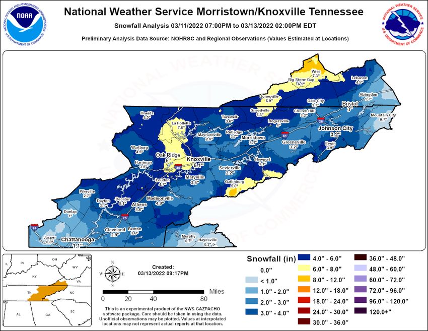
March 2022 Tennessee State Climate Summary

                                             8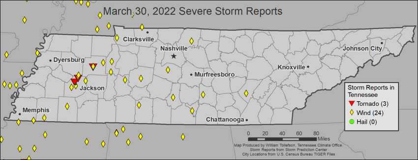
March 2022 Tennessee State Climate Summary

Drought Monitor:
Despite the drier and warmer than normal conditions in most of the state, Tennessee remained free of
drought or abnormally dry conditions on the US Drought Monitor for the month of March 2022.

                                                                                                       9
March 2022 Tennessee State Climate Summary

Soil Moisture:
The USDA Crop Progress report released March 29 rated topsoil moisture as 4% short, 72% adequate, and
24% surplus; and rated subsoil moisture as 4% short, 78% adequate, and 18% surplus across Tennessee.
Looking at the NASA SPoRT Land Information System soil moisture products, most areas of the state were
near or above normal for soil moisture from the surface down to 2 meters depth, although areas along
the mountains and northern portions of the Cumberland Plateau were running below normal for this time
of year. Looking at monthly changes in soil moisture, all areas except the western-most counties in the
state saw drops in soil moisture percentiles. However, there had been a large increase in soil moisture
during February, so these drops brought the soil moisture percentiles closer to the normal range for this
time of year.

                                                                                                      10
March 2022 Tennessee State Climate Summary
11March 2022 Tennessee State Climate Summary
Streamflow:
Averaged throughout the month, most stream gauges in Tennessee reported normal streamflow levels,
with a few streams in Middle and southwest Tennessee reporting above normal streamflow and a few
streams in northeast Tennessee and on the northern Cumberland Plateau recording below normal
streamflow. As a dry pattern set up in northeast Tennessee throughout March, there were more streams
in that area reporting below normal streamflow by the end of the month.
Miscellaneous:
Crop Conditions from USDA: Tennessee experienced varied precipitation and temperatures in March.
Some areas reported wet conditions and cold temperatures, with a few reports indicated flooding in low
areas. Fieldwork is gearing up for the growing season. Corn planting preparations are starting as
conditions allow. Pastures are reported as mostly fair. Winter wheat is reported as mostly good with little
disease. Hay and roughage supplies appear adequate for the rest of the winter season. Supplies have
lasted longer than expected despite the impacts on pastures from wet weather. Late freezes may have
impacted pastures and hay, and cold and dry conditions in East Tennessee were a concern for winter
wheat in the region.
12March 2022 Tennessee State Climate Summary
Fire Danger: The Interagency Fire Center significant wildland fire potential outlook for April shows that all
of Tennessee, along with surrounding regions of neighboring states will have normal potential for
significant wildland fires.
13March 2022 Tennessee State Climate Summary
Snow: There was one significant snowfall event in March, with widespread accumulation across the state
from March 11-12. Northern portions of the Cumberland Plateau reported the highest snow totals, but
for many areas in East Tennessee this was the largest snowfall event since the Blizzard of 1993. A total of
107 weather stations (including CoCoRaHS gauges) reported measurable snowfall during March 2022.
Spring Greenup: Maps from the US Phenology Network showing the First-leaf anomaly indicate that most
of Tennessee saw the spring greenup delayed by about a week due to cold spells in early/mid-March,
although warm weather in East Tennessee in February and March did lead to a greenup that was a few
days earlier than normal.
14March 2022 Tennessee State Climate Summary
Story of the Month:
The major stories of March 2022 were the snowstorm of March 11-12 and the high winds and wildfires
that occurred at the end of the month.
A strong cold front swept the state from March 11 to 12, bringing widespread snow accumulation across
the state, with northern portions of the Cumberland Plateau reporting the highest snow totals. For many
areas in East Tennessee this was the largest March snowfall event since the Blizzard of 1993, including
Knoxville where there were numerous reports of over 6” of snow.
15March 2022 Tennessee State Climate Summary
March 12 snow accumulation reports from the NWS Nashville Forecast Office.
There were numerous small wildland fires reported across the state at the end of the month as a few
weeks of dry weather, low humidity, and gusty winds brought dangerous fire weather conditions to
portions of the state.
In Sevier County, two large wildfires broke out and were responsible for burning more than 3,000 acres
over several days beginning March 30th. The Sevier County fires were located in the Wears Valley and
Chilhowee Mountain areas of the county, west of Gatlinburg/Pigeon Forge. The larger of the two fires,
named the Hatcher Mountain/Indigo Lane Fire, caused the evacuation of over 11,000 homes. Additionally,
schools in the area were closed and students were bussed to an evacuation center so their parents could
pick them up. There were over 200 people from 70 agencies dispatched to help fight the fires. 219
structures were impacted by the fires, some sustaining just minor damage while others were completely
destroyed. Luckily, no fatalities were reported due to the fires, but two firefighters and a civilian were
injured while fighting the fires.
16March 2022 Tennessee State Climate Summary
Satellite-derived potential fire hotspots across Tennessee and surrounding regions for the week ending March 31.
Image from the NASA FIRMS (Fire Information for Resource Management System):
https://earthdata.nasa.gov/earth-observation-data/near-real-time/firms/about-firms
Image of the Hatcher Mountain wildfire from TEMA
17March 2022 Tennessee State Climate Summary
Sevier County GIS map of the Hatcher Mountain/Indigo Lane Fire footprint and impacted structures. Accessed at:
https://arcg.is/0DWDzr
18March 2022 Tennessee State Climate Summary
Storm Reports:
*Storm Reports are based on filtered NOAA Storm Prediction Center data or local NWS storm reports. Future quality
control checks may change the official record of severe events, please see spc.noaa.gov for any updates.
There were 3 days with severe storms reported in Tennessee with a total of 3 tornados, 27 severe wind
damage reports, and no severe hail reports.
March 22
Wind:
Time Speed
Location County Lat Lon Comments
(UTC) (mph)
TENNESSEE VALLEY WEATHER AND
FACEBOOK REPORTS INDICATED SEVERAL
3 NW TREES WERE BLOWN DOWN WITH MINOR
22:07 -- WAYNE 35.21 -87.79
COLLINWOOD DAMAGE TO OUTBUILDINGS AND POWER
OUTAGES BETWEEN COLLINWOOD AND
WAYNESB (OHX)
5 NW MINOR
22:55 -- LAWRENCE 35.09 -87.22 TREE DOWN ON POWER LINE. (OHX)
HILL
March 23
19March 2022 Tennessee State Climate Summary
Wind:
Time Speed
Location County Lat Lon Comments
(UTC) (mph)
SOCIAL MEDIA PHOTO OF A REVOLVING DOOR
1 ESE
18:00 -- KNOX 35.96 -83.93 DAMAGED AT A BUSINESS IN DOWNTOWN
KNOXVILLE
KNOXVILLE. TIME IS ESTIMATED FROM RADAR. (MRX)
March 30
Tornadoes:
Time
Strength Location County Lat Lon Comments
(UTC)
A SURVEY OF THE DAMAGE FROM
WEDNESDAY EVENINGS THUNDERSTORMS
4 NNW -
23:19 EF1 MADISON 35.68 RESULTED IN THREE CONFIRMED TORNADOES
JACKSON 88.86
IN WEST TENNESSEE. THESE TORNADOES
AFFECTED AREAS IN MADISON... GIBSO (MEG)
DAMAGE SURVEY FOUND EF-1 TORNADO
4 ESE - DAMAGE FROM OLD MEDINA ROAD...
23:31 EF1 MADISON 35.75
FAIRVIEW 88.79 NORTHWEST TINTO FAR SOUTHEAST GIBSON
COUNTY. (MEG)
6 SW - EF-1 DAMAGE WAS FOUND NEAR
23:52 EF1 CARROLL 35.95
HUNTINGDON 88.48 HUNTINGDON. (MEG)
Wind:
Time Speed
Location County Lat Lon Comments
(UTC) (mph)
3 WNW BLUE 1-INCH TREE LIMBS BROKEN; SHINGLES
17:53 -- MADISON 35.72 -88.63
GOOSE BLOWN OFF. (MEG)
LARGE TREE DOWN ON POWER LINES
LAYING ACROSS THE ROAD AT E HOLMES
21:15 -- 3 S COLLIERVILLE SHELBY 35.01 -89.69
RD AND BYHALIA RD. UTILITIES
AFFECTED. (MEG)
CORRECTS PREVIOUS TSTM WND DMG
REPORT FROM 3 S COLLIERVILLE. LARGE
22:20 -- 3 S COLLIERVILLE SHELBY 35.01 -89.69 TREE DOWN ON POWER LINES LAYING
ACROSS THE ROAD AT E HOLMES RD AND
BYHALIA RD. UTILITIES AFFECTED. (MEG)
20March 2022 Tennessee State Climate Summary
Time Speed
Location County Lat Lon Comments
(UTC) (mph)
POWERLINES DOWN ACROSS THE ROAD
22:30 -- 4 W MOSCOW FAYETTE 35.06 -89.47
ON HWY 57. (MEG)
MULTIPLE TREES DOWN NORTH AND
23:00 -- BOLIVAR HARDEMAN 35.27 -89 AROUND THE BOLIVAR AREA...
PARTICULARLY NEAR HWY 179. (MEG)
SEVERAL TREES DOWN IN WESTERN
23:05 -- 8 W DOVER STEWART 36.47 -87.99
PARTS OF THE COUNTY. (OHX)
CORRECTS PREVIOUS TSTM WND DMG
REPORT FROM JACKSON. ROOF CAME
OFF AT THE FORREST COVE NURSING
23:20 -- JACKSON MADISON 35.63 -88.83
HOME NEAR THE HOSPITAL. WINDOW
BLOWN OUT AT THE HOSPITAL AS WELL.
SEVERAL (MEG)
60 MPH WIND GUST MEASURED BEFORE
23:23 60 5 WNW BEMIS MADISON 35.6 -88.92
SITE LOST POWER. (MEG)
MULTIPLE TREES DOWN ON HOUSES ON
CHRISTMASVILLE RD. ALSO REPORTS OF
23:30 -- 1 SW MEDINA MADISON 35.79 -88.79
MULTIPLE TREES DOWN DAMAGING
HOUSES ON WESTOVER RD. (MEG)
MULTIPLE TREES DOWN ACROSS
23:30 -- MEDINA GIBSON 35.81 -88.78
MEDINA. (MEG)
CORRECTS PREVIOUS TSTM WND DMG
REPORT FROM 5 WSW HUNTINGDON.
5 WSW TREE DOWN ON A MOBILE HOME ON
23:45 -- CARROLL 35.97 -88.48
HUNTINGDON OLD STAGE RD... NO ENTRAPMENT BUT
SEVERAL POWER LINES AND TREES
DOWN ACROSS C (MEG)
MULTIPLE POWER LINES AND TREES
23:45 -- HOLLOW ROCK CARROLL 36.04 -88.27
DOWN ON HWY 70. (MEG)
POWER LINES DOWN ON HWY69A...
12 ESE BUENA
0:00 -- BENTON 35.88 -88.1 TREES DOWN ON HWY 192 AND LICK
VISTA
CREEK RD. (MEG)
TREE AND POWER LINE DOWN CAUSING
0:00 -- CAMDEN BENTON 36.06 -88.09
POWER OUTAGES. (MEG)
TRAINED SPOTTER ESTIMATED 60+ MPH
0:35 60 LOBELVILLE PERRY 35.75 -87.8
WIND GUST. (OHX)
A FEW TREES DOWN IN THE COUNTY
1:10 -- CENTERVILLE HICKMAN 35.78 -87.47
WITH THE MAIN LINE OF STORMS. (OHX)
11 WNW TREE DOWN AT GENSON RD AND TN-
1:31 -- LAWRENCE 35.32 -87.5
LAWRENCEBURG 240. (OHX)
MARSHALL COUNTY EMA REPORTED A 3
MILE LONG BY 1/2 MILE WIDE SWATH OF
WIND DAMAGE OCCURRED ACROSS THE
1:50 -- 1 N LEWISBURG MARSHALL 35.46 -86.79
NORTHEAST SIDE OF LEWISBURG. A
MOBILE HOME ON VERONA ROAD LOST
MUCH (OHX)
TSPOTTER REPORT AND PHOTO OF A
2:13 -- 3 W FRANKLIN WILLIAMSON 35.93 -86.9 TREE SNAPPED IN THE FOUNDERS
POINTE NEIGHBORHOOD. (OHX)
21March 2022 Tennessee State Climate Summary
Time Speed
Location County Lat Lon Comments
(UTC) (mph)
CORRECTS PREVIOUS TSTM WND DMG
REPORT FROM 1 N LEWISBURG.
MARSHALL COUNTY EMA REPORTED A 3
2:50 -- 1 N LEWISBURG MARSHALL 35.46 -86.79
MILE LONG BY 1/2 MILE WIDE SWATH OF
WIND DAMAGE OCCURRED ACROSS THE
NORTHEAST (OHX)
FACEBOOK REPORT OF A LARGE TREE
2:52 -- 4 NE GALLATIN SUMNER 36.43 -86.41 BLOWN DOWN ONTO A CAMPER ON
GIBBS LANE. (OHX)
4 SSW A TREE WAS REPORTED DOWN ON
4:05 -- MOORE 35.23 -86.39
LYNCHBURG LOUSE CREEK ROAD. (HUN)
FACEBOOK REPORT INDICATED A SMALL
5 WNW SHED WAS BLOWN OVER AND A FEW
4:25 -- COFFEE 35.51 -86.16
MANCHESTER SMALL TREES WERE BLOWN DOWN ON
NORTON ROAD. (OHX)
6:29 -- 5 NE PALIO BLEDSOE 35.53 -85.26 A FEW TREES DOWN. (MRX)
22March 2022 Tennessee State Climate Summary
CPC Outlooks for the Next Month:
The NOAA Climate Prediction Center monthly outlooks for April show that most of Tennessee will have
equal chances for above or below normal temperatures for the month, with the exception of the
southwestern and northeastern corners of the state which are leaning towards a warmer than normal
April. The entire state is leaning towards a wetter than normal April, with chances between 33-40%.
23You can also read