LOWER SWAN LOCALITY PLAN - Draft for public comment - March 2022 - Department of Biodiversity ...
←
→
Page content transcription
If your browser does not render page correctly, please read the page content below
Draft for public comment

LOWER SWAN
LOCALITY PLAN
March 2022
Draft for public comment

Ngala kaaditj Whadjuk moort keyen kaadak nidja Boodja
We acknowledge the Whadjuk people as the original owners of this land
Draft for public comment

CONTENTS
Introduction ........................................................................................................................................................................................................................................................................................... 4
Policy Area ............................................................................................................................................................................................................................................................................................. 6
Development Outcomes ........................................................................................................................................................................................................................................................................ 8
    Social Benefits ................................................................................................................................................................................................................................................................................... 8
         Maintaining the River System and its Setting as a Community Resource .................................................................................................................................................................................... 8
         Securing Public Access to the River System ................................................................................................................................................................................................................................. 8
         Maintaining a Sense of Place ....................................................................................................................................................................................................................................................... 8
         Providing Opportunities for Water Transport .............................................................................................................................................................................................................................. 9
    Environmental Values ....................................................................................................................................................................................................................................................................... 9
         Increasing Climate Resilience ....................................................................................................................................................................................................................................................... 9
         Protecting the Natural Environment ............................................................................................................................................................................................................................................ 9
         Protecting Fringing Vegetation .................................................................................................................................................................................................................................................... 9
         Creating and Maintaining Foreshore Reserves ............................................................................................................................................................................................................................ 9
         Minimising Dredging and Channel Disturbance ......................................................................................................................................................................................................................... 10
         Implementing Responsible Drainage Management Practices .................................................................................................................................................................................................... 10
         Applying Appropriate Water Management Practices ................................................................................................................................................................................................................ 10
         Rehabilitating the River System ................................................................................................................................................................................................................................................. 10
    Cultural and Natural Heritage ......................................................................................................................................................................................................................................................... 10
         Conserving the Cultural and Natural Heritage of the River System and its Setting.................................................................................................................................................................... 11
    Design and Development ................................................................................................................................................................................................................................................................ 11
         Promoting Sensitive Design and Built Form to Complement the River Landscape .................................................................................................................................................................... 11
         Creating Linkages and Greenways ............................................................................................................................................................................................................................................. 11
         Activating the Foreshores .......................................................................................................................................................................................................................................................... 12
ACTION PLAN ....................................................................................................................................................................................................................................................................................... 12
Draft for public comment
VISION
A healthy river for all, to be enjoyed and shared, now and in the future.
The social benefits, environmental values and cultural significance of the river are respected.
Land use, design and development ensure that the river and its value to the community is protected and enhanced.Draft for public comment INTRODUCTION The Swan Canning river system is a complex and dynamic natural landscape that extends beyond the river channel. A properly functioning river alters the position of its channels and foreshore, frequently spills over its banks and occasionally occupies its floodplain. The river should be understood as this larger natural system. The Lower Swan Locality Plan guides adjacent land use, civic design, and development to ensure that the value of the river and its setting to the community is maintained. The Locality Plan brings together “on” and “off” water considerations to provide guidance for recreation, development, restoration and rehabilitation of the Swan and Canning rivers. The Locality Plan is to be read in conjunction with Corporate Policy XX – Planning for Localities along the Swan Canning Development Control Area, which establishes key development principles to direct and inform development (including use of the land and water). These principles are supported by the below series of intended locality-specific development outcomes. The development principles and outcomes are to be demonstrated as part of any proposal. The Locality Plan is adopted as policy to support the implementation of the Swan and Canning Rivers Management Act 2006 and is to be given due regard in relation to strategic and statutory planning that may affect the river. The Locality Plan is supported by an Action Plan that aims to direct strategic planning and works in the locality. The actions, while not adopted as policy, should be delivered when opportunity presents. The Action Plan will be updated as needed. Delivery of the actions is subject to funding and resources. The extent of the Lower Swan locality is iden�fied in Figure 1. The development outcomes apply to land within and affec�ng (including visually) the Swan Canning development control area and includes public and private land.
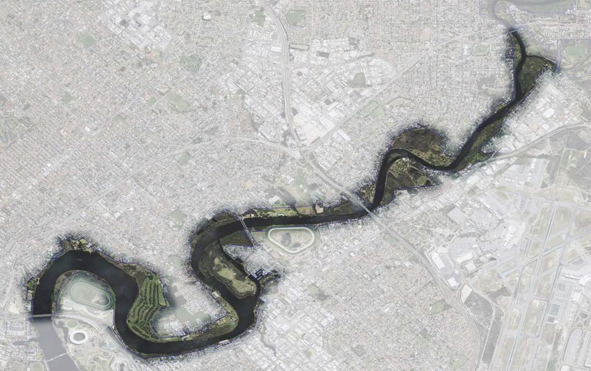
Draft for public comment

POLICY AREA
The Lower Swan locality extends from Windan Bridge to the Guildford Road Bridge and includes the confluence with the Helena River in Guildford.

 Figure 1: Lower Swan Locality
Draft for public comment

Once past Windan and Goongoonup bridges, the Swan River narrows and takes the form of large meanders around the Burswood, Maylands and Garvey Park
peninsulas. Open parkland, built and natural landscape characters are present in this locality, however it has a more natural river landscape than Perth and
Melville Waters. The relatively narrow channel is fringed by riparian vegetation of varying width and condition. The public foreshore reserve consists of many
low-lying wetland areas, such as at Berringa Park, Maylands Foreshore, Ascot Waters, Baigup Wetlands, Ashfield Flats, Garvey Park and South Guildford,
which are significant elements of natural landscape character. Other natural landscape elements include Ron Courtney Island and Kuljak Island and freshwater
springs that are located adjacent to Baigup Wetland and between Banks Reserve and Bardon Park.

Significant residential development and urban infilling has occurred. A mix of housing ranging from single residential heritage housing to medium-density
contemporary townhouses and apartments exist in the suburban areas. Higher density buildings, including multistorey apartments, hotels and commercial
buildings, are present at East Perth, Burswood, Rivervale and Ascot. The high-rise buildings are positioned on the elevated landform adjacent to the steep
foreshore embankment and extend beyond the narrow strip of fringing riparian vegetation, contrasting with Maylands foreshore on the opposite side of the
river, which is a predominantly flat, low-lying alluvial plain. In general, residential development on the northern side of the river is set back from the foreshore.
On the southern side of the river, there is generally a narrow band of natural or open parkland vegetation between the development and the river.

This locality has many public parks and recreational features that are integrated with riverside residential areas, which contribute to the natural and open
parkland character. Public access to the river and foreshore is not continuous due to historic land use, landform and private properties extending into the
floodplain or to the edge of the Swan River. However, there are numerous recreation nodes along the foreshore that provide passive and active recreational
opportunities with direct access to the water. Prominent built infrastructure within the foreshore includes the Belmont Park and Ascot Racecourses, the
Maylands Peninsula Golf Course and the East Perth Power Station which is a key heritage feature of the locality.

Water based ac�vi�es, such as fishing, sailing, kayaking, canoeing, horse swimming and water-skiing, are common in this locality.
Draft for public comment

DEVELOPMENT OUTCOMES
The Belmont Foreshore Precinct Plan applies to a por�on of this locality and is to be read as part of this policy. It applies to the City of Belmont local
government area, from Balbuk Reserve, Rivervale in the west to Hay Road, Ascot in the east.

SOCIAL BENEFITS
Maintaining the River System and its Setting as a Community Resource
4.1     Ensure that increases in density and subdivisions incorporate adequate foreshore and public open space reserves. Encourage the alignment of public
        open space abutting the foreshore reserve.
4.2     Development should maintain and enhance the quality and setting of the foreshore, particularly where there is no road interface with the foreshore
        reserve and it is a strata or multi-storey development.
Securing Public Access to the River System
4.3     Provide a safe and accessible public open space network. Particular attention should be given to public access:
            i. from Guildford Road Bridge to Kings Meadow Reserve;
           ii. from Guildford Road Bridge to Point Reserve;
         iii.  from Great Eastern Highway Bridge through Iho Park to Wilkie Street;
         iv.   from Anstey Road, through Pickering Park, to Sandy Beach Reserve, including connecting to Deakin Street;
           v.  from Ashfield Parade to Claughton Reserve;
         vi.   connections into the Tonkin Gap bridge project;
         vii.  from Garratt Road Bridge to Samphire Street;
        viii.  from Baigup Wetlands to Bath Street Reserve;
          ix.  from the Maylands boat ramp car park to Woodhouse Road, through the Maylands Peninsula Public Golf Course; and
           x.  around the Belmont Park Racecourse peninsula.
4.4     Account for the terrain, environmental values and landscape amenity of the foreshore reserve when providing public access.
           i. The design is to respond to the site and local context;
          ii. In some areas an informal path is preferred due to the topography or environmental sensitivities, such as between Point Reserve and Anstey
              Road; and
         iii. Access to the water may not always be practical or ecologically appropriate.
4.5     Move pathways away from the river’s edge to create space for foreshore treatments and restoring riparian vegetation.
Draft for public comment
Maintaining a Sense of Place
4.6 Enhance connections to the river foreshore, such as through wayfinding, from nearby community or activity centres. Particular attention should be
given to Surrey Street (Bassendean) and Hill Street (Guildford).
4.7 Use local native vegetation species within the foreshore and within public open space and road reserves that abut the foreshore to connect and
contribute to the river landscape’s sense of place.
4.8 With permission, use Whadjuk Noongar place names across the locality.
Providing Opportunities for Water Transport
4.9 Recognise the importance of the river for transport, recreation, tourism and leisure as well as its conservation and amenity value.
4.10 May consider a low-impact jetty with ferry services capacity at the East Perth Power Station and/or the Belmont Park Racecourse peninsula (where
appropriate noting the other gazetted uses of the river).
ENVIRONMENTAL VALUES
Increasing Climate Resilience
4.11 Adapt current foreshore use, infrastructure and management to allow for the river’s natural ‘flood retreat cycle’ to occur. Ensure buildings around
the foreshore are appropriately setback and other infrastructure within the reserve is designed to accommodate some inundation.
4.12 Retain and enhance existing vegetation, particularly large trees, and increase canopy coverage to combat the urban heat island effect. Encourage
the planting of local native trees within urban areas.
Protecting the Natural Environment
4.13 Protect the natural landform surrounding the river from earthworks (including filling of the floodplain), clearing and other intrusions that may impact
on the function and character of the river.
4.14 Maintain and restore natural landscape riparian elements, such as flat floodplains, wetlands, silty banks, sandy beaches and raised embankments,
and natural hydrology, such as maintaining water flows from natural groundwater springs (including those located adjacent to Baigup Wetlands and
between Banks Reserve and Bardon Park) and seasonal flooding of floodplains and wetlands. There should be no filling within the foreshore reserve.
Protecting Fringing Vegetation
4.15 Riparian trees on the riverside of development should be preserved to maintain the river’s visual character.
4.16 Reintroduce understorey and bolster fringing vegetation including to aid erosion control.Draft for public comment
Creating and Maintaining Foreshore Reserves
4.17 Protect and enhance sensitive foreshore areas, including samphire wetlands, Berringa Park, Baigup Wetlands, Ashfield Flats and Ayres Bushland.
4.18 Maintain the total area, and improve the environmental quality, of foreshore reserve in the locality.
Minimising Dredging and Channel Disturbance
4.19 Development should not restrict water flow through the floodway.
4.20 Disturbance of the riverbed is to be minimised where PFAS is present in above average concentrations, such as near stormwater outlets connected
to the airport.
Implementing Responsible Drainage Management Practices
4.21 Horse stalls are to have an impermeable floor with runoff to be directed to the reticulated sewerage network.
4.22 Implement improvements to the quality of stormwater entering the foreshore, with a focus on stormwater that discharges to the river between
Garratt Road Bridge and Windan Bridge . Implement water sensitive urban design, with the aim of incorporating at-source stormwater systems and
overland flow through vegetated systems within the catchment, rather than using end of pipe stormwater systems within the foreshore. Retrofit
stormwater/drainage pipes and trapezoidal drains where possible and retrofit piped river outlets.
Applying Appropriate Water Management Practices
4.23 Subdivisions and land use changes are to be connected to the reticulated sewerage network.
4.24 Development in unsewered areas is to be supported by a wastewater management plan that demonstrates no new sources of nutrients to the river.
4.25 Implement nutrient and irrigation industry best practice for active playing surfaces in proximity to the river, particularly in shallow groundwater
areas, including at the Belmont and Ascot racecourses and the Maylands Peninsular Golf Course. Establish buffers of native vegetation along the
river’s edge. New sporting grounds, for example ovals, are to be located outside of the foreshore reserve.
Rehabilitating the River System
4.26 Restore riparian vegetation, particularly at Belmont Park, Ascot to South Guildford, AP Hine Reserve, Bayswater Riverside Gardens, Redcliffe Bridge
salt marshes, Ashfield Flats, Sandy Beach Reserve, Kings Meadow and Helena River foreshore, Rivervale, Maylands Peninsular Golf Course and Tranby
Reserve. Succession planting is required at Point Reserve.
4.27 Link remnant wetland areas and enhance seasonally inundated riparian zones with plantings of local native species.
4.28 There is a preference for soft foreshore stabilisation approaches.Draft for public comment
4.29 The introduction of hard engineered riverbanks is to be supported by an overarching context analysis that considers the surrounding foreshore
management approaches and ensures an appropriate and integrated approach is used, including for areas of privately owned foreshore. Revetments
are to be avoided wherever possible.
CULTURAL AND NATURAL HERITAGE
Conserving the Cultural and Natural Heritage of the River System and its Setting
4.30 Protect and maintain the heritage buildings and heritage riparian infrastructure that are important landscape elements of the Swan River, including
the Garratt Road and Guildford Road bridges.
4.31 Maintain the visual connection and enhance the pedestrian connection between heritage buildings and the river foreshore, including the East Perth
Power Station and Peninsula Farm.
4.32 Protect places of Aboriginal cultural significance, including sites that may not be listed on the Aboriginal Heritage Places register.
DESIGN AND DEVELOPMENT
Promoting Sensitive Design and Built Form to Complement the River Landscape
4.33 Waterlines and ridgelines are dominant visual elements of the river. Ensure that new development is adequately set back from the foreshore and
addresses foundation stability within the lot so that it does not contribute to global instability of the adjoining foreshore reserve, particularly between
Tanunda Drive and Riversdale Road, and between Adachi Park and Graham Farmer Freeway. Construction methods are to minimise disturbance of
slopes, including cut/fill and use of retaining walls. Geotechnical reports may be required to accompany development applications.
4.34 Reduced setbacks to the Parks and Recreation reserve in the Belmont Park Racecourse peninsula may be considered where the required average
setback can still be achieved, any ground floor spaces within the standard setback area are activated and publicly accessible and a community benefit
can be demonstrated. A minimum 3.5m wide cycle/pedestrian pathway is to be incorporated adjacent to the Parks and Recreation reserve in Precinct
A and B to delineate the foreshore and the majority of the riverine edge and the foreshore reserve revegetated and remediated.
4.35 New carparking within the foreshore reserves should be set back as much as possible from the river’s edge, including relocating bays such as at
Pickering Park and Claughton Reserve.
4.36 Rock material used for foreshore works is to be limestone and laterite.
4.37 Do not support subdivision of land within the floodway.Draft for public comment
Creating Linkages and Greenways
4.38 Restore tributaries and drainage lines and promote biodiversity and habitat complexity through planting local native over, middle and understorey
species.
4.39 Enhance or create ecological linkages for local fauna between natural areas.
Activating the Foreshores
4.40 Activation in foreshore areas impacted by the floodway should be temporary, such as pop-up facilities and events with self-contained servicing.
Minor community amenities that can be inundated, such as nature-play, picnic facilities and pathways, may be accepted within the floodway. May
consider temporary food trucks/café vans at Bardon Park, Claughton Reserve, Garvey Park, Sandy Beach Reserve, Point Reserve and Kings Meadow.
4.41 Upstream of Garvey Park, community jetties are to be entirely fixed structures. Where appropriate, enhance the use of the river for kayaking and
canoeing, such as at Banks Reserve and Garvey Park. Jetty design should consider the incorporation of launching or short-term tie-up facilities for
kayaks and canoes.
4.42 Enhance passive recreation at existing park nodes by providing public facilities that enhance the community’s enjoyment of and connection to the
river environment, with a focus on nature-based activities.
4.43 Co-locate community clubs at established nodes. Ensure clubs using foreshore land incorporate safe public access including by sufficiently setting
back structures. Consolidate club facilities (with a preference for shared facilities) rather than expand multiple separate premises in the one node.
Clubs are to demonstrate a community benefit.
4.44 Ensure that commercial development within the foreshore reserve has a community focus, is small scale, occurs within established commercial
nodes, enhances the natural character of the foreshore, and ideally delivers multiple benefits or services. The established commercial node in this
locality is Peninsula Farm. Development is to be set back from the river’s edge as much as possible. New or expanded commercial development is to
be supported by an overarching context analysis that considers the broader foreshore and river uses to ensure a diversity of public facilities and
experiences. Over-water commercial development is not supported in this locality.
4.45 May consider small scale community and food and beverage development within Banks Reserve and Riverside Gardens where it can be demonstrated
to enhance the community’s enjoyment of the river environment and is consistent with the foreshore purpose of the reserve. The site should be well
connected to the principal shared path network.
4.46 Lease areas within foreshore land are to appropriately set back from the river, taking account of the site context, land use and development scale.
This includes realigning the riverside boundary of an existing lease area as part of any redevelopment of the site.
4.47 Provide opportunities to learn about river ecology, conservation, history and heritage, including through art, interpretation, signage, nature-based
play and nature-based tourism.Draft for public comment
ACTION PLAN
Action Timing Key agencies Notes
(years) (in addition to DBCA)
0-2, 2-5, 5+
4.48 Undertake long-term planning to increase the provision and width of the 5+ LGAs, DPLH Consider as part of
foreshore Parks and Recreation reserve in this locality, particularly in areas strategic planning
to accommodate the floodway, and at Fauntleroy Avenue (Ascot),
Rivervale, and between Sandy Beach Reserve and Point Reserve
(Bassendean). Account for the terrain, environmental values, landscape
amenity and anticipated public access when determining an appropriate
foreshore reserve width.
4.49 Formalise the foreshore within Belmont Trust land as Parks and Recreation 0-2 CoBe, DPLH
reserve under the Metropolitan Region Scheme to ensure continued
community use and access.
4.50 Acquire the Parks and Recreation reserve to create a continuous public 5+ DPLH Acquire consistent with
access corridor along the locality's foreshore, including along Swan View State policy and
Terrace in Maylands, Epsom Avenue to Ford Street in Ascot, Fauntleroy proactively when
Avenue, Bassendean Parade, and West Road and North Road in opportunity presents
Bassendean.
4.51 As a short-term measure, the route along West Road (Bassendean), 0-2 ToB
Bassendean Parade and North Road (Bassendean) should be enhanced
with improved way-finding, path treatments and planting of riverine
vegetation.
4.52 Investigate Ascot Waters Marina as a potential event-day ferry stop for 5+ DoT, PTA, CoBe, CoBa Driven by demand
activities at the Ascot Racecourse, and Tranby Jetty as a potential weekend
ferry stop for tourism and recreation.Draft for public comment
4.53 Undertake infill sewer connection for the Bayswater industrial area, North 5+ WC Undertake strategically
Road (Bassendean), Bassendean Parade, and West Road (Bassendean). and as part of related
proposals
4.54 Incorporate an interpretation node to recognise cultural heritage values at 5+ CoV,CoBe, CoBa To form part of foreshore
Banks Reserve, Belmont, Tranby, Ascot Waters, and Garvey Park, as improvement works in
identified in Marli Riverpark: An Interpretation Plan for the Swan and these locations
Canning Riverpark.
4.55 Undertake master planning for Riverside Gardens (including Hinds 5+ CoBa, DPLH, CoBe To inform foreshore
Reserve) and Kuljak Island, incorporating an urban forest and opportunities improvement works in
for new nature-based activities and river-related community uses. The these locations
master plans should aim to improve the natural landscape character and
public access to nature, acknowledging areas that are regularly inundated.
Investigate opportunities for the community clubs at Hinds Reserve to
share and co-locate facilities, when they are refurbished in the future.
4.56 Investigate transfer of public land on the riverside of Coolgardie Avenue to 2-5 DPLH, CoBe
the Parks and Recreation reserve under the Metropolitan Region Scheme
and its rehabilitation and incorporation into the Ayres Bushland.
4.57 Formalise a public corridor along the foreshore at the Maylands Amateur 2-5 CoBa, DPLH Undertake strategically
Boat Building Yard and the Maylands Peninsula Public Golf Course. and to form part of
Enhance recognition of the boat-building heritage of the Swan River and related proposals
improve connection of the Maylands Amateur Boat Building Yard to the
wider Peninsula Farm heritage precinct.
4.58 Investigate options for development of a shared facility incorporating 2-5 CoV To inform foreshore
kayak hire, pop-up or temporary café, public toilets and picnic facilities at improvement works in this
Banks Reserve, with the possible future provision of a multi-use location
community/food and beverage facility adjacent to Joel Terrace.Draft for public comment
4.59 Investigate connection of Bindaring Park to Pickering Park and 5+ ToB, CoBe To form part of road or
reconfiguration of The Esplanade (Ascot), to optimise provision of public foreshore improvement
open space. works and strategic
planning
4.60 Develop a master plan for Ashfield Flats and Sandy Beach that aims to 2-5 DPLH, ToB, WC To inform foreshore
improve water quality entering the foreshore, enhances the extent and improvement works in this
condition of wetland and riparian vegetation, encourages and manages location
passive recreation, responds to the ecological value of the samphire
wetlands and facilitates response to climate change over time.
4.61 Master plan Kings Meadow Reserve as an important environmental and 5+ CoS To inform foreshore
recreation site at the confluence of the Swan and Helena rivers. Consider improvement works in this
including the wider Guildford foreshore as part of the master planning location
process.
4.62 Undertake a foreshore risk assessment for the Riverpark to understand 2-5 DPLH, LGAs, DoT, Will inform management
potential climate change impacts. DWER, DFES approaches
CoBa City of Bayswater DFES Department of Fire and Emergency Services PTA Public Transport Authority
CoBe City of Belmont DoT Department of Transport ToB Town of Bassendean
CoS City of Swan DPLH Department of Planning, Lands and Heritage WC Water Corporation
CoV City of Vincent DWER Department of Water and Environmental Regulation
DBCA Department of Biodiversity, Conservation and Attractions LGA Local Government AuthorityYou can also read