Juneau Douglas Harbor - USACE Alaska District
←
→
Page content transcription
If your browser does not render page correctly, please read the page content below
Juneau Douglas Harbor

Douglas Harbor Page 2 of 10
Condition of Improvements
                             31 December 2019
                          Douglas Harbor, Alaska
                         (CWIS No. 072789, 180942)

Authorization Rivers and Harbors Act, 3 July 1958 (House Doc. 286, 84th Congress, 2nd
Session) as adopted, provides for a boat basin of 5.2 acres with entrance channel both to a depth
of -12 feet MLLW and protected by a rock jetty about 90 feet long off the northerly shore of
Juneau Isle adjacent to the basin entrance. A 130 foot breakwater extension on the northwest
side of the entrance channel, a 105 foot breakwater extension on the southeast side of the
entrance channel and a 230 foot floating breakwater were constructed under the authority of
Section 107(b) of the Rivers and Harbors Act, 14 July 1960 (Public Law 86-645), as amended.
Water Resources and Development Act of 2007, November 9, 2007 (Public Law 110-114),
Section 2022 amends Section 107(b) of Public Law 86-645 to increase the statutory limitation
for projects under this authority to $7,000,000.

  Table 1
                                                                                        Depth
  Existing Project                           Length (ft.)          Width (ft.)
                                                                                        (ft.)
  Basin                                      400                   380                  -12
  Entrance Channel                           345                   60                   -12
  Jetty                                      105
  Northwest Breakwater Extension             130
  Southeast Breakwater Extension             105
  Floating Breakwater                        230

Project Usage The small boat basin provides protected moorage for 100 small craft.
Douglas Harbor is one of three Corps of Engineers projects that provide moorage for the large
commercial fleet and recreational vessels in the Juneau/Douglas area (see Juneau Harbor and
Gastineau Channel). The government, commercial fishing, and tourism provide a unique and
diversified economy in the metropolitan area. All transportation to the area is by sea or air.

Douglas Harbor                                                                       Page 3 of 10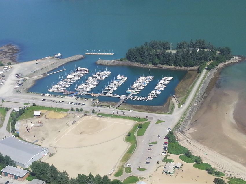
Progress of Work
 1961            Plans and specifications are prepared and the contract is awarded.
 1962            Construction of the breakwater begins in January and is completed in June.
                 Dredging of the basin follows in June and is completed in August. The
                 finished project includes gravel berm protection, gravel slope protection,
                 and quarry run slope protection rock.
 1993            A condition survey is performed in April.
 1995            Sampling and testing of harbor sediments is conducted.
 1997            The entrance channel is straightened and dredged to two feet over project
                 depth; 24,242 cubic yards of material are removed within the new limits.
 2000            The condition of the Federal project is checked by hydrographic survey in
                 May.
 2003            A Detailed Project Report is completed and approved in April for expansion
                 of the project. Vertical aerial photography is obtained in May.
 2004            A condition survey is performed in May.
 2007            Breakwater plans and specifications are prepared to protect the new
                 mooring area. Construction is scheduled for 2008.
 2008            A contract is awarded to Western Marine to construct a 130 foot rubble-
                 mound breakwater extension on the northwest side of the entrance channel
                 and a 105 foot rubble-mound breakwater extension on the southeast side of
                 the entrance channel at the end of the existing jetty on Juneau Island. Work
                 was completed in November 2008.
 2009            A project condition survey is completed in August.
 2011            The project is selected to participate in a pilot program where the Corps
                 provides engineering and design assistance to the local community for
                 dredging the Federal project. Funds were received in late August to initiate
                 the project and assist the community in obtaining environmental clearances
                 for dredging the boat basin.
 2012            A new concrete floating breakwater 230 feet long, 18 feet wide, and 8 feet
                 tall with 20 inches of freeboard and supported by pipe plies, was installed in
                 the entrance channel. [Inspection of cathodic protection should be scheduled
                 after 15 years (2027)] USACE Comprehensive Evaluation of Project
                 Datums Compliance report completed and recorded in September.
 2013            A condition survey was performed in May. In addition to the project limits,
                 a proposed disposal area was surveyed. There are 12,215 CY available to
                 Project depth and 4,605 CY available along the side slopes.

Douglas Harbor                                                                     Page 4 of 10
Progress of Work
2015 Plans and specifications were prepared to dredge the federal portion of the harbor
boat basin to -14 feet MLLW and dispose of the dredge material in Gastineau
Channel. Due to the presence of methyl mercury in the harbor sediment, the project
also includes placing a sand cap over the dredged area of the harbor and the dredge
material in the disposal site. In August, contract W911KB-15-C-0017 was awarded
to Western Marine Construction in the amount $5,797,100. The contract includes
monitoring activities during construction and 1-year after construction is completed.
Monitoring includes water quality monitoring during disposal activities, chemical
monitoring of bottom sediments and Sediment Profile Imaging (SPI) and Plan View
Imaging (PVI).
2016
Western Marine completed dredging in the harbor and placement of sand caps in the
harbor and the Gastineau Channel disposal site by early March. A total of 26,200
CY was dredged and placed in the disposal site; 4,500 cubic yards of sand cap placed
in the harbor and 42,000 cubic yards of sand cap placed at the disposal site. Post
sand cap surveys, Sediment Profile Imaging (SPI) and Plan View Imaging (PVI)
indicated an approximate 1 foot sand cap in the harbor and 4-7 feet of sand on the
main disposal mound at the disposal site. A thinner sand cap layer extended to the
flanks of the main disposal mound.
2017 One-Year Monitoring activities are completed in the harbor and Gastineau Channel
disposal site in March. Monitoring activities include a hydrographic survey,
Sediment Profile Imaging (SPI), Plan View Imaging (PVI) and chemical testing.
The harbor sand cap remains intact. A new layer of sediment has settled on top of
the disposal site sand cap. [Five-year monitoring should be scheduled for 2021]
2019 A condition survey of the harbor is conducted in March.
Table 2 Cost to Date
Project Description Cost $
072789 O&M Appropriations 8,370,240
O&M Costs 7,922,585
180942 CG Appropriations 4,614,246
CG Costs 4,614,246
CG Contributed Appropriations 1,110,104
CG Contributed Costs 1,110,106
Douglas Harbor Page 5 of 10Table 3 Range of Tides in feet
Tide Station Mean Range Diurnal Range Extreme Range
945 2210 Juneau AK 13.74 16.31 30.71
NOAA Publication Date: 02/16/2018
Controlling Depth: As of March 2019, most of the entrance channel is at project depth -
12 feet MLLW although points near the northern toe of the southern breakwater extension are
as high as -9.5 feet MLLW. Project depth -12 MLLW is effectively available throughout the
Federal portion of the basin, March 2019. Controlling depth is -10.5 under the Northeasterly
sections of the floats as you enter the basin.
Maintenance Dredging Supplement
A. General
1. The first maintenance dredging for this project is conducted Aug-Sep 1997 (a 35 year
span).
2. The entrance channel was straightened and dredged under the 1997 dredging contract.
3. A “no dredging” window from 15 April to 15 June is established by the State of Alaska.
4. Harbor is dredged to -14 feet MLLW and a sand cap is placed to a maximum finished
elevation of -13 feet MLLW to contain methyl mercury contamination in 2015/2016.
B. Sampling & Testing
1. Harbor sediment characterization performed for the City and Borough of Juneau in 2007
revealed elevated levels of methyl mercury and total mercury in the harbor sediment.
USACE permit POA-2000-495-M3 was issued to the City and Borough of Juneau in
2014 for dredging in Douglas Harbor with a requirement for sand capping and future
monitoring. USACE ultimately adopted the permit and associated special conditions for
federal dredging of 26,217 cubic yards of material in 2015. A sand cap was placed in
the harbor and over the disposal mound and the site is currently under a long term
monitoring plan. Backup documentation is available through the USACE Operations
Branch.
C. Disposal
1. Two dredge disposal sites were considered as possibilities for the 1997 contract: one, a
shallow water site across Gastineau Channel requiring additional improvement, and a
deep water site (> 100' deep) near the project entrance.
2. A deep water site was selected for the 2015 dredging with the following NAD 83
geographic coordinates.
Douglas Harbor Page 6 of 10Table 5 Disposal Area
Corner Latitude (N) Longitude (W)
1 58°16'44.90" 134°22'33.32"
2 58°16'37.85" 134°22'18.69"
3 58°16'31.20" 134°22'30.24"
4 58°16'38.25" 134°22'44.87"
3. Various options, including the possibility of upland disposal, must be considered for
future soils disposal.
D. Environmental Permits and Reports
1. USACE Permit POA 2000-495-M3 was issued to the City and Borough of Juneau on 20
June 2014 for dredging and placing sand cap in Douglas Harbor.
2. USACE subsequently received funding to dredge and cap the federal portion of the
harbor. An Environmental Assessment (EA) was disseminated by the Corps on 7 May
2015, and a Finding of No Significant Impact (FONSI) was signed by the District
Engineer on 29 May 2015.
3. A Sediment Cap Monitoring Plan dated 5 February 2015 was prepared by NewFields
and was adopted for the 2015 dredging and sand cap project.
4. A Chemical Data Report was previously prepared by the Corps in April 1995
subsequent to the sampling and testing of harbor sediments. Further sediment
characterization was performed by NewFields in November 2007. The screening level
was exceeded for mercury in all samples. All other chemicals of concern were below
screening level.
5. Tier III/IV assessment conducted in 2008 and 2011 found mercury exceeded screening
levels but there is a lack of measurable biological effects.
6. The following permits or authorizations are listed by agency below:
Table 6 Environmental Permits
Agency Name Date of Issue Date of Expiration
USACE Permit POA-2000-495-M3 20-Jun-14 n/a
Environmental Assessment May-15 n/a
Finding of No Significant Impact 29-May-15 n/a
ADEC Water Quality Certification 2-Jun-15 2-Jun-20
Douglas Harbor Page 7 of 107. Sediment samples were collected for mercury analysis before and after dredging under
the 2015 dredging contract. Four out of four samples in the harbor, three out of eight
samples at the disposal site and three reference samples taken 3-5 miles down Gastineau
Channel exceeded the PSDDA screening levels prior to dredging. After dredging, three
out of four samples in the harbor, three out of seven samples at the disposal site and
three reference samples taken 3-5 miles down Gastineau Channel exceeded the PSDDA
screening levels. Chemical sampling was not performed after placement of the sand cap
but will be included in the 1-year monitoring in 2017.
8. In 2017, one year after sand cap placement, two out of four samples in the harbor, five
out of eight samples at the disposal site and three reference samples taken 3-5 miles
down Gastineau Channel exceeded the PSDDA screening levels. Harbor sample results
are in areas where sand was minimal either due to breakwater rock or being on the side
slope where sand was not required. Disposal site results appear to be due to the
accumulation of new sediment from the surrounding environment settling on top of the
sand cap.
Douglas Harbor Page 8 of 10Douglas Harbor, Douglas, Alaska
Oblique of Douglas Harbor, July 2013
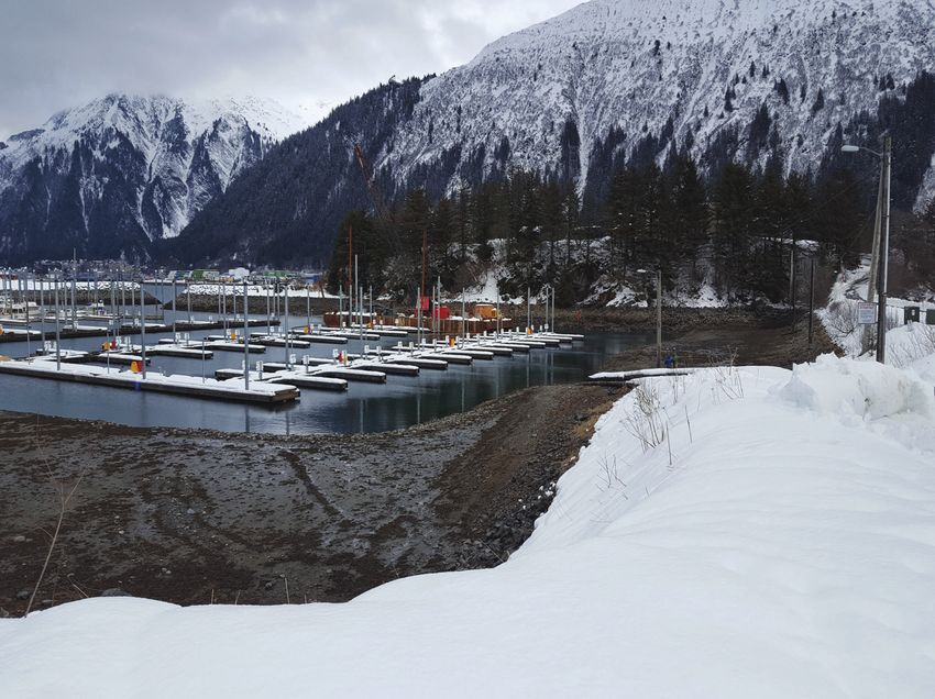
Douglas Harbor, March 2017
Douglas Harbor Page 9 of 10Douglas Harbor, Douglas, Alaska
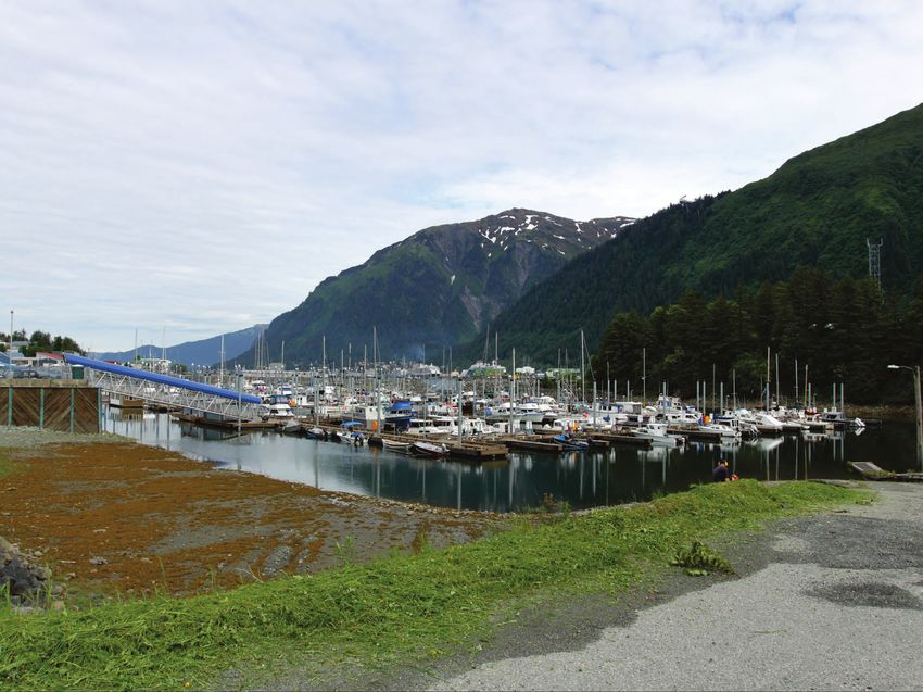
Entrance Channel, June 2017
Douglas Harbor, June 2017
Douglas Harbor Page 10 of 10You can also read