Hydrological surveys of the Lake Peschanoe and the Sernovodsky isthmus of Kunashir island (Greater Kuril сhain) - E3S Web of Conferences
←
→
Page content transcription
If your browser does not render page correctly, please read the page content below
E3S Web of Conferences 265, 02007 (2021)                                     https://doi.org/10.1051/e3sconf/202126502007
APEEM 2021

         Hydrological surveys of the Lake Peschanoe
         and the Sernovodsky isthmus of Kunashir
         island (Greater Kuril сhain)
         Mikhail Y. Grishchenko1,2,*, Vasiliy I. Krylenko1, Viktoria T. Ozhgikhina1, Artyom V.
         Gorbarenko1
         1 M.V.    Lomonosov MSU, Faculty of Geography, 119991, Moscow, Russia
         2 State   nature reserve "Kurilskiy", 694500, Yuzhno-Kurilsk, Russia

                        Abstract. The article is devoted to the study of the largest lake of the
                        island of Kunashir – the lake Peschanoe (means Sandy) – and the adjacent
                        sections of the coast of the Sea of Okhotsk. Despite its considerable size
                        and relatively easy transport accessibility, the lake still remains relatively
                        poorly explored. The topography of its bottom was studied, in particular,
                        the maximum depth of the lake (23 m) was measured; hydrological and
                        hydrobiological surveys of the lake were conducted; the influence of the
                        wind on the intensity of mixing of the lake’s waters was assessed; lagoon
                        origin of the lake was proven; the coastline of the Sea of Okhotsk in the
                        vicinity of the lake was examined. It was revealed that the lake lost
                        connection with the sea long enough so that there are no signs of salt in its
                        water, but not so long enough that it stopped being inhabited by
                        mesohalobiotic crustaceans. The influence of typhoons on the mixing of
                        the lake’s waters is very great that is surprising for such a large lake. This
                        is facilitated by its geographical position on the Sernovodsky isthmus, due
                        to which it is open to both winds blowing from east and west.

         1 Introduction
             Due to its remote location and peculiar natural conditions, Kunashir is still a poorly
         explored island. As a zone of active development of modern volcanism, the Kuril Islands
         (and Kunashir, in particular) are relatively well studied in geological and geomorphological
         terms. Geological structure and geomorphology of the island were generally described in
         the middle of the second half of the last century in the works of G.S. Gorshkov [1], E.K.
         Markhinin [2, 3], I.V. Melekestsev [4, 5] and others. In addition, there are a number of
         works on the structure and development of the island’s coastal relief [6, 7], as well as on
         some paleogeographical issues [8-10]. These works describe the nature of the hydrological
         objects. There is a range of works devoted to individual hydrological objects, in particular,
         to volcanic lakes [11, 12]. At the same time, there are still no generalizing works devoted to
         the hydrological issues of Kunashir. Researchers also pay little attention to major

         *
             Corresponding author: m.gri@geogr.msu.ru

   © The Authors, published by EDP Sciences. This is an open access article distributed under the terms of the Creative
   Commons Attribution License 4.0 (http://creativecommons.org/licenses/by/4.0/).
E3S Web of Conferences 265, 02007 (2021)                            https://doi.org/10.1051/e3sconf/202126502007
APEEM 2021

         hydrological objects that are not characterized by pronounced confinement to volcanic
         systems, such as the lake Peschanoe.
              The purpose of the adjustment work is to fill the gap in the study of the largest lake on
         the island as a hydrological object. The Sernovodsky Isthmus, most of which is occupied by
         Lake Peschanoe, is an interesting natural object due to the peculiarities of its geo-
         morphological structure. The study of these objects is of interest not only from a scientific,
         but also from an ecological and educational point of view, since the territory belongs to the
         Kurilskiy State Nature Reserve, and here the possibility of organizing a full-fledged
         ecological-tourist route is being considered.
              Kunashir is the southernmost island of the Greater Kuril chain and the fourth largest
         area of the Kuril islands. The island is washed by the sea of Okhotsk from the west and by
         the Pacific ocean from the east. Kunashir is separated from the Japanese island of Hokkaido
         by the Kunashir and Izmeny straits, from the Iturup island by the Catherine strait, and from
         the islands of the Lesser Kuril ridge by the South Kuril strait. The relief of the island is
         predominantly low-mountain; in some areas, it is mid-mountain, hilly, or flat; the volcanic
         origin of the main forms is clearly expressed. The island is formed by four volcanic masses,
         which are connected by low-lying isthmuses. The highest point of the island is the Tyatya
         volcano, 1819 m high. The coasts of the island are mostly rocky, steep with narrow rocky
         beaches, less often gentle with sand dunes and sandy beaches; the coastline is very slightly
         indented. The rivers of the island rise mostly in mountains; the valleys are deeply incised;
         rifts and waterfalls are quite common. Watercourses are characterized by a pronounced
         flood regime; discharge increases in the period of typhoons lasting from July to October
         inclusive. The lakes are of lagoon and volcanic origin. Kunashir's climate is oceanic, rather
         humid. The annual rainfall in Yuzhno-Kurilsk is up to 1300 m, while the interannual
         variability in rainfall is very high. Summer is cool, rainy, with frequent fogs, south and
         south-east winds. Typhoons and windstorms are rather common in summer and autumn.
         Winter snowfalls are alternated with thaws; winds blow mainly from the north and north-
         west.
              The lake Peschanoe is the largest lake of the island. It is located on the Sernovodsky
         (means Sulphur Water) isthmus, dividing the volcanic masses of the volcanoes of
         Mendeleev and Golovnin and representing a lowland plain, most of which is occupied by
         the basin of the lake. Its length is 4.5 km; width is 2.4 km; an area is 7.14 km2; the average
         depth is 4.2 m; the maximum depth is 23 m. The Pacific sector of the Sernovodsky isthmus
         is occupied by a swampy red thin forest; the dune field, very interesting from a
         geomorphological point of view. It is confined to the sea of Okhotsk; it is composed of
         polymictic sands (to which, probably, the lake owes its name) formed, apparently, as a
         result of wind activity. These characteristic features of the geosystems of the Sernovodsky
         isthmus are determined by the features of its wind regime – it is a natural channel for air
         flows from both the south and east, and from the west [13]. The lake lies in the territory of
         the Kurilsky nature reserve and its conservation zone.

         2 Materials and methods

         Field work on the lake Peschanoe was performed in the period from August 8, 2019 to
         August 29, 2019. It included installing a water gauging station and monitoring of the water
         level; bathymetric survey; temperature survey and temperature profiling; selection of
         hydrobiological samples of benthic organisms from the shallow water of the lake and from
         surrounding water bodies; study of the coastline of the lake. To measure the temperature
         and electrical conductivity of the water, the Mark 603 conductometer was used. The water
         level was monitored using a pole marked every 10 centimeters. The bathymetric survey was

                                                       2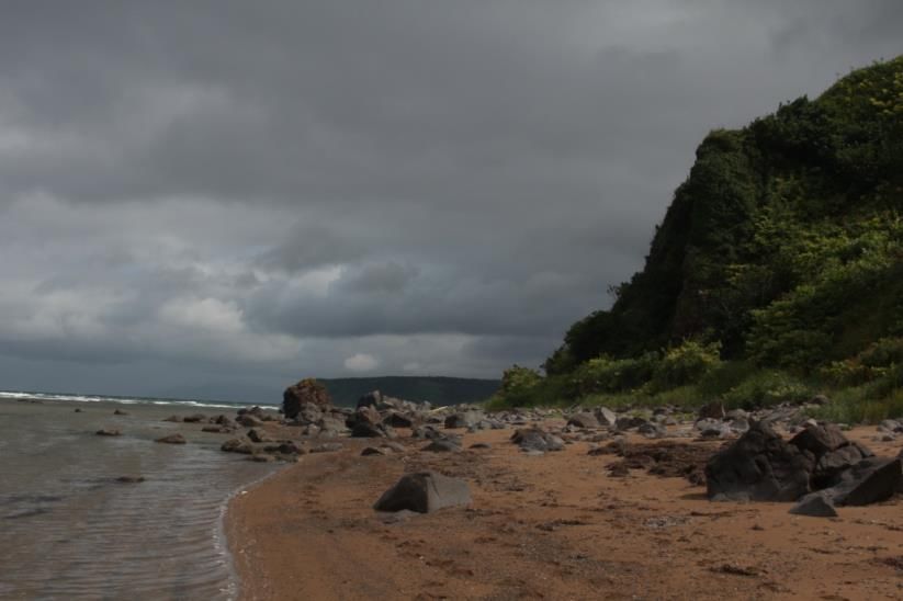
E3S Web of Conferences 265, 02007 (2021) https://doi.org/10.1051/e3sconf/202126502007
APEEM 2021
conducted using Lowrance echo sounder and YSI CastAway CTD probe. Temperature and
salinity indicators were also measured using this probe. The coastline of the lake and the
coastline of the sea of Okhotsk in the region of the Sernovodsky isthmus from the
Znamenka bay to the mouth of the Asin spring were studied.
3 Results and discussion
3.1 Bathymetry
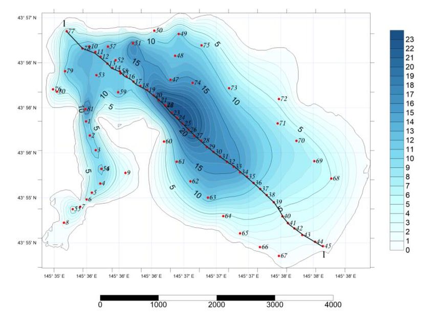
Based on the results of the bathymetric survey we generated a map of the depths of the lake
Peschanoe (fig. 1). It clearly shows that in the central part of the lake there is a deep basin
with characteristic depths of approximately 23 meters. To the northwest and southeast of it,
the depth of the lake decreases. The depth of the sea of Okhotsk near the shores of Kunashir
is approximately 20 m that reveals that there was a strait between two volcanic massifs on
the site of the lake Peschanoe. But due to geomorphological processes, such as the
accumulation of sedimentary material on the isthmus from the sea of Okhotsk and from the
Pacific ocean, the lake lost connection with the ocean. Therefore, it is a lake of lagoon type.
The lake Peschanoe is the remnant of the deepest part of the ancient strait, separated from
the sea by enclosures from marine and lagoon sediments.
Fig. 1. Bathymetric map of the lake Peschanoe.
3.2. Salinity
Further work, namely, measurements of the salinity of the lake’s waters, showed that the
lake lost connection with the sea a very long time ago, since no signs of sea water were
found in it. To determine the exact date of loss of connection with the sea, a series of works
should be conducted to study the watercourses flowing into the lake Peschanoe, namely, to
calculate their flow rate and to identify their mineralization. Thanks to this information and
the materials we have already collected (topography of the lake’s bottom), it will be
3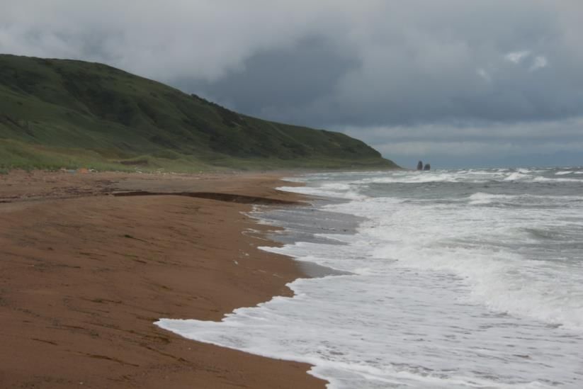
E3S Web of Conferences 265, 02007 (2021)                                 https://doi.org/10.1051/e3sconf/202126502007
APEEM 2021

         possible to calculate the period, during which salt water would have reached the current
         mineralization values.

         3.3 Temperature

         Over the entire period of studies, we set 81 hydrological stations, each of which measured
         the depth and temperature distribution over it. In the deepest place (23 m), we recorded a
         temperature of 15.8°С – one of the lowest temperatures in the observed period. The surface
         temperature in the shallowest place coincides with the air temperature registered that day –
         21.8°C. The most interesting phenomenon is the lens of cold water remaining after the
         previous large-scale mixing and cooling of water associated with the passage of a typhoon
         (fig. 2).

         Fig. 2. The distribution of temperature over the depth of the lake Peschanoe, August 11, 2019

             The dynamics of water temperature is very pronounced when comparing the
         temperature distribution over depth before a typhoon, immediately after it, and a few days
         after it. The longitudinal profile of the lake showed two edges of the lake bottom with a
         sharp difference in depths: 5 m and 10 m. Due to this feature, the relief of the lake’s
         bottom, the undulation in days with a calmer wind regime is not intensive enough to mix
         the water so much. Undulation continues till the first edge (5 meters of depth) with a
         pronounced isotherm. In the region of this edge, we observed a thermocline. The same
         phenomenon was observed near the second edge of the lake’s bottom (10 m).

         3. 4 Fauna

         The fact that the lake Peschanoye was previously connected to the sea is also confirmed by
         the composition of its fauna. It consists mainly of mesohalobiotic species of crustaceans,
         widely represented in reservoirs of the same type on the other islands of the archipelago.
         We noted five species from four families. Anisogammarus annandalei (Shen, 1954) and A.
         kygi (Derzhavin, 1923) (Anisogammaridae), which practically do not form joint clusters,
         are common for lakes and for adjacent streams. Among the isospods, we found specific
         mesohalobiotic Gnorimosphaeroma ovatum (Gurjanova, 1933) (Sphaeromatidae),
         Neomysis awatschensis misids (Brandt, 1851) (Mysidae), and penaeidae Palaemon

                                                           4
E3S Web of Conferences 265, 02007 (2021) https://doi.org/10.1051/e3sconf/202126502007
APEEM 2021
paucidens (De Haan, 1844) (Palaemonida). But the presence of many brook species in the
waters of the lake indicates its strong desalination.
3.5 Formation of the lake. Sea coast
The formation of lagoon lakes is generally characteristic of the island. The vast majority of
the large lakes of Kunashir are of lagoon origin. The coastline of the island is very
dynamic; materials composing the shore are constantly redeposited. Abrasion shores are
widespread – steep slopes abruptly terminate near the sea of Okhotsk or the Pacific ocean;
narrow rocky beaches are confined at their foot. Sandy beaches are less common. These are
rocky benches covered by sand. The coastline is slightly indented, without large bays.
Since the studied section of the coast of the sea of Okhotsk is confined to the low-lying
isthmus Sernovodsky, sandy beaches here are more widespread than on the island as a
whole (fig. 3), but here can be observed the same patterns. The section from Znamenka bay
to the beginning of the ledge of the Znamenka cape is represented by narrow sand and
pebble beach and a fairly wide sea terrace. In the area of the Znamenka cape, the coastline
acquires a distinct abrasion character, with a large number of boulders; the beach becomes
sandy-boulder with rocky outcrops of tuffs and small outcrops of basalts; the width of the
beach is reduced to 10 meters; its narrow strip stretches along the sodded dead cliff (fig. 4).
Directly on the cape are the Dva Brata (means Two Brothers) kekurs of basalt origin,
approximately 15 meters high. Such a nature of the shore is associated with the refraction
of sea waves near the capes.
Fig. 3. The sandy beach between the Znamenka cape and the Danilovsky stream mouth. In the
background - kekurs Dva Brata.
5E3S Web of Conferences 265, 02007 (2021) https://doi.org/10.1051/e3sconf/202126502007
APEEM 2021
Fig. 4. Rocky beach near the Znamenka cape.
This results in steep waves, and active bank abrasion, whereas sediment is intensively
accumulated in the bays with active deposition of the massive material. The accumulative
section of the coast lying farther stretches from Cape Znamenka to the mouth of the
Danilovsky spring. It is a relatively wide (50-60 meters) sandy beach with an avant-dune up
to 2 meters high, turning into a small sea terrace with a width of 100-150 meters followed
by bedrock slope. Directly on the Sernovodsky isthmus, the beach retains its width, but
after 1st sea terrace starts a dune field (sand dunes) forming a land plot between the sea of
Okhotsk and the lake Peschanoe. From the mouth of the Danilovsky spring to the cape
Otatomi, the strip of the beach narrows to 10-20 meters; in this place, a large number of
lumps are found on the beach. Right at the cape Otatomi, the nature of the coast is similar
to the nature of the coast at the cape Znamenka – it becomes stony and narrow. Farther, the
beach expands and becomes sandy-boulder; in this place, it is 30 meter wide; the height of
the dune is approximately 2 meters; an extensive sea terrace stretches up to 200 meters
wide, cut through by the valleys of the Lobanov and Asin springs.
Our study area revealed that the width of the beaches tends to reduce to the capes
whereas the widest beaches tend to be confined to the coastal areas south of the capes.
Perhaps this is due to the prevailing instability of the northern rhumbs [14]. The considered
section of the coast stretches from the southwest to the northeast, so the abrasion force of
the waves is directed to the coastline at an angle. This leads to the movement of beach-
forming sediments in the southern parts of the bays, where they accumulate and form
beaches of greater width.
4 Conclusions
1. The Lake Peschanoe is the remnant of the deepest part of the ancient strait, separated
from the sea by enclosures from marine and lagoon sediments, i.e. this lake is of a lagoon
type. It lost connection with the sea for quite a long time, since there are no signs of sea
water in it anymore.
2. The fauna of the lake Peschanoe is based on mesohalobiotic species of crustaceans,
widely represented in reservoirs of the same type in the Kuril islands. Moreover, the
presence of many brook species in the waters of the lake indicates that the rate of its
desalination has decreased significantly.
6E3S Web of Conferences 265, 02007 (2021) https://doi.org/10.1051/e3sconf/202126502007
APEEM 2021
3. The passage of typhoons over the island of Kunashir leads to very intensive mixing of
the lake’s waters, which is facilitated by its geographical position on the isthmus
Sernovodsky, due to which it is open to both winds blowing from the Pacific ocean and
winds blowing from the sea of Okhotsk.
4. In the area from the Znamenka bay to the mouth of the Asin spring, we found a pattern of
reducing the width of the beaches to the capes and the confinement of the widest beaches to
coastal areas south of the capes.
References
1. G.S. Gorshkov, Volcanism of the Kuril island arc. (Nauka, Moscow, 1967) (in
Russian).
2. Y.K. Markhinin, Volcanism of Kamchatka and the Kuril Islands. Tr. Labor. vulkanol.
AN SSSR, Vol. 17, 64-155 (Publishing house of the Academy of Sciences of the
USSR, Moscow, 1959) (in Russian)
3. Y.K. Markhinin, Magmatism and the relationship of minerals, (Gosgeoltekhizdat,
Moscow, 1960) (in Russian)
4. I.V. Melekestsev, Kamchatka, Kuril and Commander islands, 337-344 (Nedra,
Moscow, 1974) (in Russian)
5. I.V. Melekestsev, O.A. Braytseva, L.D. Sulerzhitskiy, N.N. Kozhemyaka,
N.V.Ogorodov, I.A. Yegorova, Y.G. Lupikina, Volcanism and the depths of the Earth,
68-74 (Nauka, Moscow, 1971) (in Russian)
6. A.P. Kulakov, Quaternary coastlines of the Sea of Okhotsk and the Sea of Japan,
(Nauka (Siberia), Novosibirsk, 1973) (in Russian)
7. A.M. Korotkiy, N.G. Razzhigayeva, L.M. Mokhova, L.A. Ganzey, T.A.
Grebennikova, V.B. Bazarova, Tikhookeanskaya geologiya, 15(1), 53-59 (1996) (in
Russian)
8. A.M. Korotkiy, N.G. Razzhigayeva, T.A. Grebennikova, L.A. Ganzey, L.M.
Mokhova, V.B. Bazarova, L.D. Sulerzhitskiy, K.A. Lutayenko, Tikhookeanskaya
geologiya, 18 (1), 25-40 (1999) (in Russian)
9. N.G. Razzhigayeva, T.A. Grebennikova, V.B. Bazarova, L.D. Sulerzhitskiy,
L.A.Ganzey, V.S. Pushkar', A.V. Chernov, Tikhookeanskaya geologiya, 19(2), 73-86
(2000) (in Russian)
10. N.G. Razzhigayeva, L.A. Ganzey, Sedimentation conditions of island territories in the
Pleistocene-Holocene (Dal'nauka, Vladivostok, 2006) (in Russian)
11. M.Y.Grishchenko, E.V.Belozyorov, M.I. Karashova, E.D. Kornilova, N.A. Maksakov,
A.V. Nepomnyashchaya, D.V. Petrov, Geoinformatsionnoye kartografirovaniye v
regionakh Rossii: materialy X Vserossiyskoy nauchno-prakticheskoy konferentsii
(Voronezh, 14-16 noyabrya 2018 g.), 33-38 (Nauchnaya kniga, Voronezh, 2018) (In
Russian)
12. D.N. Kozlov, R.V. Zharkov, Vestnik KRAUNTs, 14(2), 30-35 (2009) (In Russian)
13. L.M.Alekseyeva, V.V. Belashko, G.A.Voronov, et al., South Kuril islands (natural-
economic essay) (Yuzhno-Sakhalinsk, 1992) (In Russian)
7You can also read