Geological controls on petroleum plays and future opportunities in the North Sea Rift Super Basin - GeoScienceWorld

Page created by Byron Daniel
 
CONTINUE READING
Geological controls on petroleum plays and future opportunities in the North Sea Rift Super Basin - GeoScienceWorld
Geological controls on                                                                               AUTHORS

                   petroleum plays and future                                                                           John R. Underhill ~ Centre for
                                                                                                                        Exploration Geoscience, Institute of
                                                                                                                        GeoEnergy Engineering, School of Energy,
                   opportunities in the North Sea                                                                       Geoscience, Infrastructure & Society,
                                                                                                                        Heriot-Watt University, Edinburgh Campus,
                   Rift Super Basin                                                                                     Riccarton, Edinburgh, United Kingdom;
                                                                                                                        present address: Interdisciplinary Centre for
                   John R. Underhill and Nick Richardson                                                                Energy Transition, School of Geosciences,
                                                                                                                        Meston Building, King’s College, Aberdeen
                                                                                                                        University, Aberdeen, United Kingdom;
                                                                                                                        john.underhill@abdn.ac.uk
                   ABSTRACT                                                                                             John R. Underhill is the director of the
                   The North Sea Super Basin is a trilete rift system located in the                                    Interdisciplinary Centre for Energy Transition
                                                                                                                        and professor of geoscience and energy
                   maritime waters of the United Kingdom, Norway, Denmark, Ger-
                                                                                                                        transition at Aberdeen University, Scotland.
                   many, and the Netherlands. Created after a phase of regional ther-                                   He is the academic executive director of the
                   mal doming in the Middle Jurassic, the rift basin consists of the                                    Centers of Doctoral Training in Oil & Gas and
                   Viking Graben, Central Graben, and Moray Firth Basin and their                                       in GeoNetZero. He populates the Scottish
                   surrounding platform areas. Synrift extensional activity occurred                                    Science Advisory Council and United
                   during the Upper Jurassic followed by postrift thermal subsidence                                    Kingdom’s (UK) Exploration Task Force. John
                   from the Cretaceous to the present day. The basin’s main Upper                                       is a recognized expert on the North Sea Basin
                   Jurassic (Humber or Viking Group) source rocks were deposited                                        and is leading efforts to repurpose it for
                                                                                                                        carbon storage and the energy transition. He
                   contemporaneously with rifting. Their subsequent subsidence his-
                                                                                                                        has been an AAPG member for almost 40
                   tory led to progressive maturation, initially focused in the grabens,                                years during which time he has received
                   but becoming ever more extensive with time. Maximum burial of                                        AAPG’s George C. Matson, Grover E. Murray
                   the Upper Jurassic occurs at the present day leading to the efficient                                 Distinguished Educator, and Ziad Beydoun
                   charge of a diverse array of overlapping plays. The only exception                                   awards as well as the Geological Society’s Lyell
                   occurs in western parts of the Moray Firth rift arm, where Ceno-                                     Medal and their Energy Group’s Silver Medal.
                   zoic uplift arrested the maturation of Upper Jurassic source inter-                                  He is the corresponding author of this paper.
                   vals. However, Middle Jurassic (paralic), Lower Jurassic (marine),                                   Nick Richardson ~ Oil & Gas Authority
                   and Middle Devonian (continental) lacustrine source rocks                                            (OGA), Aberdeen, United Kingdom;
                   reached maturity there too and created an additional local petro-                                    Nick.Richardson@ogauthority.co.uk
                   leum system. The North Sea’s reservoirs span the entire geological                                   Nick Richardson leads the Exploration and
                   column and all of the post-, syn- and prerift megasequences.                                         New Ventures team for the UK OGA. He has a
                   Despite being stratigraphically older, the Devonian–Middle Juras-                                    B.A. degree in geology from Oxford University,
                   sic (prerift) reservoirs receive charge because the Upper Jurassic                                   an M.Sc. degree from The University of
                   source rocks lie structurally deeper in the graben.                                                  Edinburgh, and a Ph.D. from ETH Zurich. Nick
                      Since oil first flowed from the North Sea in 1975, 15 fields have                                    worked for Shell, Maersk Oil, and Dana
                   been found to contain more than 1 billion BOE in recoverable                                         Petroleum prior to joining the OGA in 2016.
                   reserves and more than 95 billion BOE have been extracted to
                                                                                                                        ACKNOWLEDGMENTS
                   date, making it one of the most significant petroleum basins in
                                                                                                                        This paper was first presented at the AAPG
                   the world. Production from the area allowed the United Kingdom                                       Super Basins Conference in Houston in March
                   and Norway to exceed their energy needs and become net                                               2018. J.R.U. acknowledges Charles Sternbach,
                                                                                                                        Claudio Bartolini, and AAPG Editor Robert K.
                   Copyright ©2022. The American Association of Petroleum Geologists. All rights reserved.              Merrill for their encouragement and invitation
                   Gold Open Access. This paper is published under the terms of the CC-BY license.                      to publish the outcomes of the study. We
                   Manuscript received May 22, 2020; provisional acceptance July 1, 2020; revised manuscript received   thank Duncan Erratt and the editors of the
                   May 6, 2021; final acceptance May 7, 2021.
                   DOI:10.1306/07132120084

                   AAPG Bulletin, v. 106, no. 3 (March 2022), pp. 573–631                              573
Downloaded from http://pubs.geoscienceworld.org/aapgbull/article-pdf/106/3/573/5542947/bltn20084.pdf
by guest
Geological controls on petroleum plays and future opportunities in the North Sea Rift Super Basin - GeoScienceWorld
thematic set for their constructive and helpful                      exporters for two decades. However, rates have declined signifi-
              reviews. The paper builds upon the work                              cantly, and the rift system is now considered to be a mature petro-
              undertaken by numerous students based in                             leum province. Despite the smaller volumes and reduced size of
              the Grant Institute of Earth Science at The
                                                                                   accumulations, companies continue to seek, identify, and drill
              University of Edinburgh and in the Centre for
                                                                                   prospects that will extend the life of the basin. The continued
              Exploration Geoscience in the Institute of
              GeoEnergy Engineering at Heriot-Watt                                 exploration activity and field development has led to an estimate
              University. Shell is thanked for financial                           that approximately 10–20 billion bbl of oil equivalent remains
              support for the Wouter Hoogeveen                                     to be developed. With many fields now depleted, efforts are
              Laboratory in which some of the work was                             increasingly focused upon decommissioning and the repurposing
              undertaken and for supporting J.R.U.’s                               and reemergence of the basin for an alternative (renewable) low-
              participation in the AAPG Super Basins                               carbon future that faces the energy transition and challenge to
              meeting. Paul Renaut (Sparos Graphics) is
                                                                                   meet stringent net zero emission targets. These include the evalu-
              thanked for drafting the diagrams. The UK
                                                                                   ation of safe subsurface storage sites for carbon dioxide, hydrogen,
              OGA, Norwegian Petroleum Directorate, and
              Danish Energy Agency are thanked for the                             methane, and compressed air, and the development of new
              publication of analyses derived from the                             energy integration projects such as coupled blue hydrogen, green
              resource assessments for their respective                            hydrogen, platform electrification using wind turbines, geother-
              offshore areas, available on their websites                          mal energy, gas-to-wire, and geothermal initiatives. The latter
              under the relevant licenses. We thank the staff                      will all become increasingly important as the basin addresses
              who support the OGA’s National Data                                  the energy transition and challenge to meet net zero emission
              Repository, whose dedication has enabled the
                                                                                   targets.
              public release of UK data on which many of
              our interpretations are based. Nick
              Richardson’s contribution has been approved
                                                                                   INTRODUCTION AND CONTEXT
              by the operations director of the OGA. The
              authors also acknowledge and credit the staff
              of the OGA and predecessor organizations                             Super basins are defined as those sedimentary basins from which
              (Department for Business, Energy and                                 more than 5 billion BOE have been produced and at least 5 billion
              Industrial Strategy; Department of Energy and                        BOE of reserves and undeveloped resources have also been identi-
              Climate Change; Department for Business,                             fied (Sternbach, 2018, 2020). As such, they host the most prolific
              Enterprise and Regulatory Reform;                                    and efficient petroleum systems in the world. Several prospective
              Department of Trade and Industry, etc.) for the                      sedimentary basins occur in the northwestern European continen-
              skill and care that they have exercised, and
                                                                                   tal shelf, yet only two meet the criteria that allows them to be clas-
              continue to exercise, in maximizing the value
              of the North Sea and wider United Kingdom                            sified as global super basins. One is the Anglo-Polish trough (also
              Continental Shelf for the benefit of the nation.                     referred to as the Southern Permian Basin), which stretches from
                                                                                   eastern England to Poland via the Netherlands, Germany, and Den-
                                                                                   mark (Figure 1). The other is the North Sea rift system, which
                                                                                   largely straddles the international borders of the United Kingdom,
                                                                                   Norway, and Denmark (Figure 1). The hydrocarbon volumes
                                                                                   extracted from both of these super basins places them in the top
                                                                                   25 productive basins of all time.
                                                                                        The aim of this paper is to describe the key factors that control
                                                                                   and underpin the exploration history, petroleum systems, and vol-
                                                                                   umes that lead to the North Sea rift being classified as a global super
                                                                                   basin. The basin’s geological success is founded on the presence of
                                                                                   one major and several minor source rocks (Cornford, 1998), multi-
                                                                                   ple reservoir play levels, occurrence of excellent regional top, and
                                                                                   intraformational seals. The oil and gas traps display a variety of
                                                                                   structural styles, an ideal timing of maturation after trap formation,
                                                                                   and the occurrence of highly efficient migration pathways. The
                                                                                   result of the favorable disposition of the geological elements has

          574                The North Sea Rift Super Basin
Downloaded from http://pubs.geoscienceworld.org/aapgbull/article-pdf/106/3/573/5542947/bltn20084.pdf
by guest
Geological controls on petroleum plays and future opportunities in the North Sea Rift Super Basin - GeoScienceWorld
10°W               5°W                      0°                    5°E             10°E          15°E          20°E                 25°E           30°E

                                                                                                                                                       NPB - Northern Permian Basin
                                                                                                                                                       MNSH - Mid North Sea High

                                                                                          ben
                                 West Shetland                                                                                                         MVS - Midland Valley of Scotland
                                    Basin                                                                                                              EB   - Egersund Basin

                                                                                Viking Gra
                    60°N                                                                                                                               OMF - Outer Moray Firth

                                                                                                NORTH SEA RIFT
                                                                                                SUPERBASIN
                              Inner Moray Firth

                                                                     OMF                               EB

                                                                               Ce
                                                                                                      NPB

                                                                                 nt
                                                                     PB

                                                                                   ra
                                                     MVS         N

                                                                                     lG
                                                                                       ra
                                                                                         be
                                                                                                            Ringkøbing - Fy
                                                                           MNSH                                            n High

                                                                                           n
                    55°N

                                                                                                  Anglo - Polish Su
                                        East Irish                                                                        per Basin
                                        Sea Basin                              East Midlands
                                                                               Province
                                                                                                            Groningen

                                 Southern
                                 Ireland                   Weald Basin
                                 Basin

                    50°N                                         Wessex Basin
                                                                                                                                                   0                km              500

                   Figure 1. Map showing the geographical extent of the main petroleum systems of the northwestern European continental shelf and the
                   position of the North Sea Rift Super Basin in relation to the Anglo-Polish Super Basin (or Southern Permian Basin), its Northern Permian Basin
                   counterpart, and other significant petroleum systems such as the West Shetlands, East Irish Sea, Wessex, and Weald Basins. The North Sea rift’s
                   petroleum system encompasses the three rift arms (Viking Graben, Central Graben and Moray Firth) as well as the Egersund Basin and Inner
                   Moray Firth outliers.

                   led to successful development of clastic and carbonate                                           Vail et al. 1984; Underhill 1991a, b; Galloway et al.,
                   reservoirs, the stratigraphy for which spans the Phaner-                                         1993; Partington et al., 1993a, b; Rattey and Hayward,
                   ozoic (Figure 2) throughout the rift system (Figure 3).                                          1993), plume-related volcanism and rifting (Underhill
                        As well as its immediate impact for the economies                                           and Partington, 1993, 1994), salt tectonics (halokine-
                   of the United Kingdom, Norway, and Denmark,                                                      sis; Penge et al., 1993; Davison et al., 2000a, b), clastic
                   exploration for and production from the North Sea                                                depositional systems (Johnson and Stewart, 1985),
                   has been a major stimulus for understanding the                                                  and injectites (Hurst et al., 2005), among others. The
                   generic development of rift systems. The knowledge                                               stratigraphy, geological evolution and exploration his-
                   obtained through seismic acquisition and drilling activ-                                         tory of the North Sea has been comprehensively docu-
                   ity in the super basin has been deployed to great effect                                         mented in a series of landmark publications (Wood-
                   in other extensional settings (Davison and Underhill,                                            land 1975; Illing and Hobson 1981; Rønnevik et al.,
                   2012), and several seminal papers resulted from the                                              1983; Brooks and Glennie 1987; Abbots, 1991; Hard-
                   studies in the North Sea that have had global applica-                                           man, 1992; Parker 1993; Steel et al., 1995; Glennie,
                   bility to rift systems. Examples include those with                                              1998a; Fleet and Boldy 1999; Evans et al., 2003;
                   impact on sedimentary basin evolution (e.g., McKen-                                              Gluyas and Hitchens, 2003; Dore and Vining, 2005;
                   zie, 1978), subsidence and compaction trends (Sclater                                            Vining and Pickering, 2010; Bowman and Levell,
                   and Christie, 1980; White and Latin, 1993; Nadin                                                 2018; Goffey and Gluyas, 2020), each of which con-
                   et al., 1995), seismic and sequence stratigraphy (e.g.,                                          tain an extensive set of references.

                                                                                                                                           UNDERHILL      AND   RICHARDSON          575
Downloaded from http://pubs.geoscienceworld.org/aapgbull/article-pdf/106/3/573/5542947/bltn20084.pdf
by guest
Geological controls on petroleum plays and future opportunities in the North Sea Rift Super Basin - GeoScienceWorld
Age in Millions of Years
                                                                   0

                                                                        CENOZOIC
                                                                                            Neogene

                                                                                                                                    POSTRIFT MEGASEQUENCE
                                                                                            Paleogene

                                                                                                                   O
                                                                                                                                                                                                                                                                                     R

                                                                                                                   E
                                                                                                                                                                                        Uplift                                   Balder Fm
                                                                                                                                                                                                                                                                                     R

                                                                                                                   P
                                                                       66 Ma
                                                                                                                                                                                                                                  Shetland

                                                                                                                   Upper
                                                                                                                                                                                                    Chalk                                                                            R
                                                                                                                                                                                                    Group                          Group

                                                                                            Cretaceous
                                                                                                                                                                                                                                                  Plenus Marl

                                                  100                                                                                                                                                                                                                                R

                                                                                                                                                               INTRAPLATE SETTING
                                                                                                                                                                                                          Cromer Knoll Group
                                                                                                                   Lower
                                                                        MESOZOIC

                                                                                                                                  SYNRIFT                                                                                      Humber Group                                     SR R
                                                                                                             Upper
                                                                                                                                                                                                                                                                                   R
                                                                                                                                                                                                                                                                                   R
                                                                                            Jurassic
                                                                                                                   Lower Middle

                                                                                                                                                                                                                                Fladen Group
                                                                                                                                                                                                                                                                                SR R
                                                                                                                                                                                        Doming                                                                                     R
                                                                                                                                                                                                                                                        Brent Group
                                                  200                                                                                                                                                                                  Dunlin Group                                R
                                                                                                                                                                                                                                                                                SR R
                                                                                                                                                                                                                                       Banks Group                                 R

                                                                                                                                                                                                                         ity
                                                                                                                                                                                                                                               Humber/Viking Group

                                                                                                                                                                                                                     form
                                                                                            Triassic                                                                                                            Uncon                  Hegre Group                                 R
                                                                       251 Ma
                                                                                                                                                                                                                                                Zechstein Group
                                                                                                                                                                                                         merian

                                                                                                                                                                                                                                                                                     R
                                                                                            Permian                                                                                                                                 Rotliegend Group                                 R
                                                                                                                                                                                                 Mid Cim
                                                                                                                   Upper
                                                                                            Carbonifeous
                                                                        UPPER PALEOZOIC

                                                                                                                                                                                                                                     Variscan
                                                                                                                                                               VARISCAN PLATE CYCLE
                                                                                                                                    PRERIFT MEGASEQUENCE

                                                  300
                                                                                                                                                                                                                                   Unconformity

                                                                                                                                                                                                                                                                                SR
                                                                                                                   Lower

                                                                                                                                                                                                                                                                                SR
                                                                                                                                                                                                                                                                                     R
                                                                                                        Devonian

                                                                                                                                                                                                                                 Eday Shales
                                                                                                                                                                                                                                                                                SR

                                                  400

                                                                       419 Ma
                                                                                                                                                                                                      Caledonian
                                                                                                                                                               CALEDONIAN PLATE CYCLE

                                                                                             Silurian                                                                                                Unconformity
                                                                                                                                                                                                                                                  LEGEND
                                                                        LOWER PALEOZOIC

                                                                                                                                                                                                                                                   R     Reservoir
                                                                                            Ordovician
                                                                                                                                                                                                                                                   SR    Source Rock
                                                                                                                                                                                                   NW Scotland

                                                                                                                                                                                                                                                         Contractional Tectonics
                                                                                                                                                                                                   Succession
                                                                                                                                                                                                    Foreland
                                                                                                        Cambrian

                                                  500                                                                                                                                                                                                    Extensional Tectonics

                                                                       541 Ma

                                                                       PRECAMBRIAN BASEMENT
                                                                                                                                                                                                    Lewisian Fractured
                                                                       AND ITS TORRIDONIAN COVER                                                                                                        Basement
                                                                                                                                                                                                                                                        Moine Schist

                                                                                          Mudstone                                                          Chalk                                                                              Deformed Metamorphics
                                                                                          Sandstone                                                         Volcanics                                                                          Igneous Basement
                                                                                          Shale                                                             Evaporites                                                                         Unconformity (Missing Section)
                                                                                          Conglomerate                                                      Heterolithic Clastic Sequences

          Figure 2. Stratigraphic column depicting the main plate cycles, unconformity-bound tectono-stratigraphic (pre-, syn-, and postrift) megase-
          quences, the occurrence of key source rock intervals, and the predominant reservoir plays in the basin. The prospective sedimentary reservoirs
          range in age from the Devonian to the Eocene. Although they are predominantly clastic depositional systems, upper Permian (Zechstein Group)
          and Upper Cretaceous (Chalk Group) carbonates also make a contribution to production in the central North Sea. E 5 Eocene; O 5 Oligocene; P
          5 Paleocene.

          576                The North Sea Rift Super Basin
Downloaded from http://pubs.geoscienceworld.org/aapgbull/article-pdf/106/3/573/5542947/bltn20084.pdf
by guest
Geological controls on petroleum plays and future opportunities in the North Sea Rift Super Basin - GeoScienceWorld
Legend
                                                                                                                                                                                                           62°N
                                      Stratigraphic Age
                                            Quaternary
                                            Neogene                                                                 Magnus
                                                                                                                                         Snorre
                                            Paleogene
                                            Upper Cretaeous

                                                                                                Vi ki ng Grab
                                                                                                                             Statfjord            Gullfaks
                                            Lower Cretaceous
                                                                                                                              Brent           Kvitebjørn                                                   61°N
                                            Upper Jurassic
                                                                                                                        Ninian
                                            Middle Jurassic                                                                                                        Troll
                                            Lower Jurassic                                                                                   Oseberg

                                                                                                             en
                                            Triassic
                                            Paleozoic

                                                                                                                                                                                                           60°N
                                                                                                                                        Frigg

                                                                                                                      Beryl

                                                                  DEVONIAN SOURCED INNER                                                Grane
                                                                  MORAY FIRTH PETROLEUM
                                                                  SYSTEM ‘OUTLIER’                                                                                                                         59°N
                                                                                                                                                  Johan
                                                                            Scapa &                                                               Sverdrup
                                                                            Claymore
                                                                                                                    Brae
                                                                   Moray Firth
                                                                                             Piper                          Sleipner
                                                                                                                                                       GEOGRAPHIC EXTENT OF THE
                                                                        Captain                                                                        NORTH SEA RIFT’S UPPER
                                                                               Goldeneye                                                               JURASSIC SOURCED
                                                       Beatrice
                                                                                                                                                       PETROLEUM SYSTEM
                                                                                                                                                                                                           58°N

                                                                                                                  Forties
                                                                                 Buzzard

                                                                                                                                                                                                           57°N

                                                                                                                                                            Ekofisk

                                                                                                                                    Fulmar
                                                                                                                                                                 Eldfisk
                                       Symbol Size                                                                      Ce
                                                                                                                             ntr                                Valhall
                                       Discovered Volumes                                                                          al
                                                                                                                                        Gr             Argyll
                                       Resources (2P)                                                                                        ab                                                            56°N
                                                                  10 BBOE                                                                         en

                                                                                       N                                                                                            Tyra
                                                                  5 BBOE
                                                                                                                                                                                 Halfdan
                                                                                                                                                                                           Dan
                                                                  2 BBOE
                                                                  1 BBOE               0          50                 100 km
                                                                  500 MMBOE
                                                                  100 MMBOE                                                                                                                                55°N
                                                                  20 MMBOE

                                      4°W                         2°W                      0°                                           2°E                                4°E                       6°E

                   Figure 3. The geographical extent of the distribution of fields classified by reservoir age and size with the field volumes illustrated by relative
                   diameter of the circles. Fifteen of the rift’s fields contain recoverable reserves of more than 1 billion BOE (BBOE), and a further 10 have recov-
                   erable reserves in excess of 700 million BOE (MMBOE). Seven of the largest fields sit in the Norwegian Sector: Troll, which contains more than
                   11 BBOE, Ekofisk (4.6 billion [B] barrels), Statfjord (4.4B), Oseberg (3.4B), Johan Sverdrup (2.7B), Gullfaks (2.5B), and Snorre (2B). The other
                   three lie in the United Kingdom sector: Forties (2.9M), Brent (2.7B), and Ninian (1.3B). As well as showing where the largest fields reside, the
                   diagram serves to demonstrate that the fields hosting Middle Jurassic reservoirs dominate the North Viking Graben and Paleocene ones are the
                   most significant in the Central Graben. The mapped extent of the Upper Jurassic Humber Group sourced petroleum system and the Devonian-
                   sourced “outliers” in the Inner Moray Firth rift arm and Egersund Basin are highlighted. 2P 5 proven plus probable reserves.

                                                                                                                                                                            UNDERHILL      AND   RICHARDSON       577
Downloaded from http://pubs.geoscienceworld.org/aapgbull/article-pdf/106/3/573/5542947/bltn20084.pdf
by guest
Geological controls on petroleum plays and future opportunities in the North Sea Rift Super Basin - GeoScienceWorld
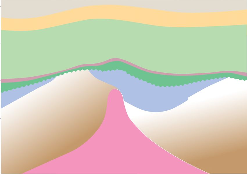
Significant advances in technology through                                               was not in place and only a few isolated wells were
          enhanced seismic acquisition, processing, and imaging                                        drilled in undisputed nearshore “territorial” waters
          together with improved drilling methods have                                                 that extended 5–20 km from the coast. Control over
          contributed to an ever-increasing understanding of                                           deeper waters that extended to the edge of the conti-
          the subsurface geology. The progressive sharpening                                           nental shelf, defined by the 200-m isobath, was con-
          of geological concepts resulting from the research in                                        tested by nation states. Because the North Sea lay in
          the North Sea combined with technological advances                                           shallower depths, the countries with a coastal
          and the construction of robust engineering networks of                                       boundary followed rules laid down by the 1958
          fields and pipeline infrastructure provided the platform                                      Geneva Convention, whereby equidistance outward
          upon which to explore and develop the super basin. The                                       from the nearest opposed coastline defined the median
          very same solid technical foundation, engineering, and                                       line. Significantly, that agreement meant that seismic
          drilling technology and infrastructure now offers new                                        surveys could be acquired prior to licensing arrange-
          opportunities to extend its life and major efforts are                                       ments being in place and the first offshore survey was
          not only going in to near-field exploration (NFE) or                                          shot in Danish waters in 1963 using 50-lb dynamite
          infrastructure-led exploration but also toward repurpos-                                     charges, and some 14,000 km had already been
          ing the basin to face the low-carbon energy transition in                                    acquired by 1967 (Childs and Reed, 1975).
          an effort to meet net zero emissions targets.                                                     The Continental Shelf Act (Legislation.gov.uk,
               Finally, having largely stable and attractive fiscal                                     1964) was passed by the United Kingdom Parliament
          (tax) regimes (Brzozowska et al. 2003), regular licens-                                      in 1964 and set out the rules for offshore licensing at
          ing rounds, a relatively rapid turnover of fallow acreage                                    the time. Similar laws were ratified in Denmark and
          leasehold, a governmental demand for indigenous oil                                          Germany in the same year, in Norway in 1965, and
          and gas to guarantee secure supply, and the public                                           finally, in the Netherlands in 1968. Although there
          release of data have all helped to promote its explora-                                      was consistency in defining quadrants by 1 of latitude
          tion, appraisal, development, and production history                                         and 1 of longitude, there were important differences
          (Brennand, 1984; Brennand et al., 1990).                                                     in the shape and size of individual license blocks. The
                                                                                                       United Kingdom subdivided their quadrants into 30
                                                                                                       blocks of approximately 200 km2; Norway decided
          EARLY HISTORY OF LICENSING AND                                                               to have larger subdivisions and defined 12 blocks in
          EXPLORATION                                                                                  each quadrant, each of which are approximately 500
                                                                                                       km2. Denmark settled upon 32 blocks per quadrant,
          There had been a long history of exploration success in                                      and the Netherlands and Germany both went for 18.
          several onshore areas of northwestern Europe prior to                                             Having agreed the size of license blocks and a pro-
          the development of the North Sea. Over the course of                                         cedure for exploration and exploitation in offshore
          the twentieth century, petroleum systems were well                                           waters, the United Kingdom led the way by launching
          established in the East Midlands, Midland Valley                                             the First Seaward Licensing Round on September 17,
          of Scotland, and Lancashire in the United Kingdom                                            1964. The outcome of the applications saw 53 licenses
          (Figure 1) (Lees and Cox, 1937; Lees and Taitt,                                              consisting of 394 blocks awarded to 51 companies that
          1945) as well as parts of Germany and the Nether-                                            formed part of 22 joint venture consortia. The first
          lands. The latter provided the catalyst for offshore                                         Norwegian licensing round for offshore exploration
          exploration in the North Sea with the drilling of the                                        was held in 1965 and included 278 of the 346 blocks
          Slochteren-1 well in 1959 and Ten Boer-1 well 4 yr                                           available for award. The first offshore licensing round
          later that discovered and appraised the giant Gro-                                           in the Netherlands was held in 1968. By way of con-
          ningen gas field in northern Holland (Stauble and Mil-                                        trast, in Denmark, the first and sole initial concession
          nus, 1970; de Jager and Visser, 2017). Its discovery                                         was granted to A. P. Møller-Maersk back in 1962 and
          renewed speculation that oil and gas reserves might                                          covered the entire offshore area. That was subse-
          be present in offshore basins beneath the North Sea.                                         quently amended in 1981 and paved the way for the
               Despite new-found interest in moving exploration                                        first Danish offshore licensing round to take place in
          activity offshore, there was no practical way of doing so                                    1984. No formal licensing rounds have been held in
          because the prerequisite legislation to govern licensing                                     offshore waters of Germany and individuals, corporate

          578                The North Sea Rift Super Basin
Downloaded from http://pubs.geoscienceworld.org/aapgbull/article-pdf/106/3/573/5542947/bltn20084.pdf
by guest
Geological controls on petroleum plays and future opportunities in the North Sea Rift Super Basin - GeoScienceWorld
bodies or commercial partnerships have been able to                                 As a consequence, licenses were offered over large
                   apply at any time.                                                                  swaths of the United Kingdom Continental Shelf
                        The first well drilled on United Kingdom licensed                               (UKCS).
                   acreage was Amoseas’ 38/29-1 well, which was                                             Although very few of the blocks in the northern
                   spudded in the Dogger Bank area on December 26,                                     North Sea initially attracted bids, one exception was
                   1964. Drilled some 200 km east of the English coast,                                the Shell/Esso joint venture, who bid for, and were
                   in what is now recognized as the mid North Sea high                                 awarded, block 211/29 in the third Licensing Round
                   (i.e., outwith the North Sea rift system as it would                                in 1970, with a commitment to acquire seismic data
                   now be defined), it was plugged and abandoned as a                                   and drill a well. Early explorers had little understanding
                   dry hole. Twelve other wells followed, all of which                                 of the stratigraphy that they might encounter. How-
                   were drilled farther south in the shallow waters of                                 ever, rather than this being a deterrent, there was gen-
                   the southern North Sea. The fourth well, British Petro-                             uine excitement and much speculation in the Shell/
                   leum’s (BP) 48/6-1, discovered gas in Permian (Rotlie-                              Esso joint venture as to what the drill bit might encoun-
                   gende) sandstones (in what was to become the West                                   ter especially in a seismically opaque package lying
                   Sole field) in 1965, thus paving the way for the offshore                            beneath a prominent unconformity (originally termed
                   part of the Anglo-Polish Basin to be opened up. It was                              the “X horizon” by operators in the early years of explo-
                   soon followed by gas discoveries by Conoco (Viking),                                ration). Some interpreters suggested that the surface
                   Shell and Amoco (Leman and Indefatigable), and Phil-                                represented a nonconformity and predicted that wells
                   lips Petroleum (Ann and Deborah). Arco made a fur-                                  would encounter nonprospective igneous or metamor-
                   ther discovery in Triassic sandstones in 1966 (Hewett                               phic basement below similar to the Scottish Highlands
                   field; Cumming and Wyndham, 1975).                                                   and Norway either side of the North Sea (Bowen,
                        Exploration moved north into the central North                                 1975). Those of a more optimistic mindset drew
                   Sea and led to the first oil discoveries being made in                               encouragement from the fact that the initial seismic
                   the North Sea rift system itself in Danish waters at                                data showed some dipping reflectors beneath the
                   Anne (1966), Roar and Tyra (1968), and Arne                                         unconformity (Bowen, 1975, 1992). They also drew
                   (1969). In Norway, early discoveries made at Valhall                                attention to best-fit restorations of the Atlantic (e.g.,
                   (1967) and Cod (1968) were followed by success at                                   Bullard et al., 1965), which placed the area closer to
                   the giant Ekofisk field by Phillips Petroleum in Decem-                               rift systems of East Greenland (Haller, 1971), where
                   ber 1969. The latter discovered oil in lower Cenozoic                               many of the stratigraphic, sedimentary, and structural
                   (Danian) and Upper Cretaceous carbonate reservoirs                                  components of a prospective petroleum system were
                   contained in a broad, open anticline created by salt                                recognized (Birkelund and Perch-Nielsen, 1969; Sur-
                   movement (halokinesis) of upper Permian (Zechstein                                  lyk et al., 1971, 1974; Surlyk and Birkelund, 1972; Sur-
                   Group) evaporites.                                                                  lyk, 1978).
                        The first oil to be discovered in the United King-                                   Drilled in 1971, at a location some 500 km north-
                   dom sector came when Amoco drilled Paleocene                                        northeast of Aberdeen, the 211/29-1 well was at the
                   clastics at the Montrose field and BP followed suit by                               time the most northerly offshore exploration well. Its
                   discovering the giant Forties field in the same reservoir                            target was an elongate four-way closure of the
                   interval in October 1970. In the same month, Shell dis-                             so-called X horizon defined using a sparse grid of
                   covered oil in upper Paleozoic (Permian) reservoirs at                              two-dimensional seismic data (Bowen, 1975). Its out-
                   Auk field, and the following year, Hamilton did like-                                come was to confound the skeptics, however, since it
                   wise at the Argyll field (Pennington, 1975). Because                                 proved that major oil-bearing Middle Jurassic clastic
                   it was oil rather than gas that was discovered, all of                              reservoirs lay beneath the “X,” which was rechristened
                   these discoveries proved to be the game changer that                                and thereafter referred to as the Base Cretaceous
                   really triggered the appetite for further frontier explo-                           unconformity. With the fourth Licensing Round
                   ration in deeper, less hospitable waters of the northern                            imminent, the well was quickly completed in the
                   North Sea. So, with an active oil-prone petroleum sys-                              Lower Jurassic and kept on a very strict tight-hole sta-
                   tem proven and multiple levels to explore, the race to                              tus so as not to alert competitor companies to the sig-
                   acquire acreage in the North Sea gathered pace and                                  nificance of the find. The subsequent appraisal and
                   subsequent licensing rounds were keenly contested.                                  testing only occurred in 211/29-2, which not only

                                                                                                                              UNDERHILL   AND   RICHARDSON   579
Downloaded from http://pubs.geoscienceworld.org/aapgbull/article-pdf/106/3/573/5542947/bltn20084.pdf
by guest
Geological controls on petroleum plays and future opportunities in the North Sea Rift Super Basin - GeoScienceWorld
found a 545 ft oil column but also located a deeper                                          which to extend geological observations and interpre-
          Triassic–Lower Jurassic (Statfjord Formation) reser-                                         tations from onshore outcrops to the subsurface of
          voir, albeit water-bearing at this location. The latter                                      the North Sea (e.g., Woollam and Riding, 1983; Voll-
          was to add pay at Brent and prove to be a major reser-                                       set and Dore, 1984; Partington et al., 1993a; Hesketh
          voir in other fields across the province including the                                        and Underhill, 2002), and the definition of new lith-
          Statfjord field from which it took its name.                                                  ostratigraphic units in the offshore (e.g., Rhys, 1974;
               The Brent discovery stimulated exploration activ-                                       Deegan and Skull, 1977 etc.). Conversely, the inte-
          ity for similar targets in the East Shetland Basin on the                                    gration of the seismic, well, and core data acquired
          western flank of the North Viking Graben during the                                           in the pursuit of petroleum reserves in the buried
          aforementioned fourth United Kingdom offshore                                                rift has added massive value to the understanding of
          licensing round. That round remains the only one in                                          the tectonic, stratigraphic, and sedimentological
          which financial bids were required and opened in                                              development and evolution of northwestern Europe.
          public. Such was Shell/Esso’s desire for more prime                                          The rich database also provides the foundation
          acreage in the same area that they tabled a bid of £21                                       upon which to evaluate sites for safe subsurface
          million to secure block 211/21, which subsequently                                           storage of carbon dioxide (CO2), hydrogen, and
          proved to be some £13 million higher than the next                                           methane gas as the basin evolves to face a low-
          nearest bid for it. Encouraged by the success seen in                                        carbon future.
          the United Kingdom northern North Sea, the Norwe-                                                 Integration of the subsurface data from onshore
          gian authorities made a special award of blocks 33/9                                         and offshore areas with field studies has demonstrated
          and 33/12 in the area in August 1973. The subsequent                                         that the North Sea domain was preceded by and sited
          drilling campaign led to the discovery of numerous                                           upon two complete Phanerozoic (Caledonian and
          giant fields either side of, and in some cases straddling,                                    Variscan) plate tectonic cycles (Figure 2), both of
          the border between the United Kingdom and Norway                                             which involved the construction (rift-drift), subduc-
          in what became known as the “Brent province.” These                                          tion, accretion of major (Iapetus and Rheic) oceans
          included the discovery of Cormorant (1972), Thistle                                          and their destruction through continental collision
          (1972), Ninian (1974), Statfjord (1974), Snorre                                              and mountain building (Ziegler, 1982, 1990a; Glennie
          (1974), Heather (1976), and Gulfaks (1978) in the                                            and Underhill 1998; Underhill, 2003).
          northern North Sea. Major discoveries were also                                                   Since the end of the (Permian–Carboniferous)
          made during the same period at Beryl (1972) in the                                           Variscan orogeny, the area has lain in an intraplate set-
          South Viking Graben, and Beatrice (1976) in the Inner                                        ting and, hence, only been affected by intraplate pro-
          Moray Firth.                                                                                 cesses that have primarily taken the form of extension
               Despite being found after the initial oil discoveries                                   and contraction (structural inversion) caused by far-
          in the province, the honor of being the first North Sea                                       field (intraplate) stresses driven by Alpine (Tethyan)
          oil producer belongs to the Permian (Rotliegende and                                         and Atlantic deformation. The early Cenozoic could
          Zechstein Group) reservoirs of Argyll field, with the first                                    arguably be considered an exception to this general
          oil on stream via a tanker in the Thames Estuary in June                                     intraplate setting, however, since the stratigraphic
          1975. Development of Paleogene reservoirs of the cen-                                        development of the British Isles was more closely asso-
          tral North Sea occurred in parallel to Argyll though and                                     ciated with the opening of the north Atlantic Ocean
          soon led to oil flowing through the Forties Pipeline Sys-                                     that propagated north at that time. Sea-floor spreading
          tem to Cruden Bay and Hound Point near Edinburgh                                             was initiated in the early Eocene, leading to creation
          later the same year. Oil from the Brent province came                                        of oceanic crust, and continental drift between Green-
          on stream on November 25, 1978, through the Sullom                                           land and northwestern Europe, a process that
          Voe terminal on the Shetland Islands.                                                        continues to the present day. The main tectonic conse-
                                                                                                       quences largely take the form of diffuse extension and
                                                                                                       structural inversion caused by the compressional reac-
          GEOLOGICAL EVOLUTION                                                                         tivation of former normal faults and deformation
                                                                                                       caused by thermal effects associated with the genera-
          The exploration activity that has occurred over the                                          tion and decay of mantle plumes under the North
          past six decades has provided a wealth of data upon                                          Sea and in Iceland.

          580                The North Sea Rift Super Basin
Downloaded from http://pubs.geoscienceworld.org/aapgbull/article-pdf/106/3/573/5542947/bltn20084.pdf
by guest
Geological controls on petroleum plays and future opportunities in the North Sea Rift Super Basin - GeoScienceWorld
The Caledonian Plate Cycle                                                          controlled by the occurrence and reactivation of Cale-
                                                                                                       donian and other basement lineaments together with
                   The early Paleozoic history of the British Isles and                                the presence of the aforementioned granitic plutons
                   North Sea areas was dominated by the late                                           (Underhill et al., 1988; Corfield et al., 1996). An
                   Cambrian–late Silurian, Athollian (former Grampian),                                east-west–striking passive continental margin devel-
                   and Caledonian orogenies, which are the tectonic prod-                              oped across much of southern parts of England and
                   ucts of continent-ocean, continent-continent collision,                             Wales that consisted of south-dipping normal fault sys-
                   and major transpression (Glennie and Underhill,                                     tems (Glennie and Underhill, 1998). To the north, a
                   1998). Prior to these events, the North Sea area com-                               series of intracontinental extensional half graben char-
                   prised three different continental fragments (Avalonia,                             acterized the East Midlands and northern England.
                   Baltica, and Laurentia) that were widely separated by                               Where the basement lineaments or the margins of Cal-
                   the southwest-northeast–striking Iapetus ocean and                                  edonian granitic intrusions were not favorably oriented
                   the northwest-southeast–striking Tornquist Sea. Clo-                                to take up dip-slip extensional displacement, strike- or
                   sure of the Iapetus ocean is thought to have been dia-                              oblique-slip deformation resulted across northern
                   chronous and achieved by both northwest- and                                        Britain (Underhill et al., 1988, 2008; Corfield et al.,
                   southeast-directed subduction (Phillips et al., 1976)                               1996).
                   and continental suturing and resulted in the creation                                    Continental sequences dominate the synrift depo-
                   of the Laurussia mega-continent.                                                    centers of northern Britain (e.g., the Midland Valley of
                        The collisional processes led to the formation of a                            Scotland; Underhill et al., 2008), reflecting their prox-
                   major (Caledonian) mountain range that stretched                                    imity to the Caledonian Mountains from which they
                   from the southern United States to eastern Canada                                   werederived.Moresoutherlydepocentersarecharacter-
                   (Appalachians) through northern Britain to the north-                               ized by marine sequences, with those of northern
                   ern end of the Greenland-Scandinavia craton. The line                               England dominated by fine-grained clastics (e.g., the
                   of closure is marked by a northeast-southwest-striking                              Bowland and Hodder Shales) that form source rocks
                   suture that can be traced from the Shannon Estuary in                               thatchargepetroleum systems intheEast IrishSea Basin,
                   western Ireland through Northern Ireland, beneath                                   East Midlands, and southern North Sea (Besly, 2018).
                   the Solway Firth and Northumberland trough to the                                   The same units also create shale gas targets (e.g., in Lan-
                   northeastern coast of England. The so-called “Iapetus                               cashire, Yorkshire, and Nottinghamshire). Farther
                   suture” passes out into the North Sea, to meet its Torn-                            south, the lower Carboniferous depocenters are domi-
                   quist counterpart at a triple junction in the central                               nated by carbonates that line the northern margin of
                   North Sea before reappearing in Norway. Each plate                                  the Rheic ocean and pass southward into basinal mud-
                   is characterized by different crustal rheology, some-                               stones of Devon and Cornwall (Ziegler, 1982, 1990a, b).
                   thing that is readily apparent from seismic tomography                                   The Variscan orogeny marked the subduction,
                   (Crowder et al., 2020). Reactivation of the structural                              accretion, and eventual closure of the Rheic ocean and
                   trends was to be a significant factor in later deforma-                              the creation of the supercontinent Pangaea. It led to
                   tion. The final stages of Caledonian collision were                                  the former passive continental margin being telescoped
                   accompanied by the intrusion of Early Devonian gran-                                to form a mountain belt and a northward-tapering, flex-
                   ites that subsequently played an important role in cre-                             ural foreland (foredeep) basin, the depocenter for
                   ating extensional fault blocks during the periods of                                which stretched from southwestern Ireland through
                   Carboniferous and Late Jurassic extension.                                          southern Wales, to Kent, the Ardennes of Belgium
                                                                                                       and beyond. The effects of the contractional deforma-
                   The Variscan Plate Cycle                                                            tionand associatedmetamorphism placeeffectivelimits
                                                                                                       on the southern extent of Devonian and Carboniferous
                   The Variscan plate cycle lasted from the Devonian to                                play fairways leading to the exploration potential being
                   the late Carboniferous. It began with a phase of Devo-                              severely challenged and extremely limited in south-
                   nian rifting initially driven by intramontane collapse of                           western England and the Western Approaches.
                   the Caledonian Mountains and the creation of the                                         Farther north, the intracratonic extensional and
                   Rheic ocean to the south. The structural configuration                               strike-slip basins of central and northern parts of the
                   of the British area appears to have been partially                                  United Kingdom, such as the Midland Valley of

                                                                                                                              UNDERHILL   AND   RICHARDSON   581
Downloaded from http://pubs.geoscienceworld.org/aapgbull/article-pdf/106/3/573/5542947/bltn20084.pdf
by guest
Scotland, Bowland Basin, Widmerpool Gulf, Edale                                              initially dominated by postrift thermal subsidence,
          trough, and Northumberland Basin, accommodated                                               which was accompanied by the development of wide-
          Variscan deformation through the contractional reac-                                         spread salinas and mudflats ascribed to the Mercia
          tivation (structural inversion) of the former exten-                                         Mudstone Group onshore and the equivalent units
          sional faults and regional uplift (Underhill et al.,                                         that are ascribed to the Haisborough Group offshore
          1988, 2008; Fraser and Gawthorpe, 1990; Underhill                                            (e.g., Rot, Muschelkalk, and Keuper halites and
          and Brodie, 1993; Corfield et al., 1996; Anderson                                             mudstones).
          and Underhill, 2020). Footwall closures, inversion                                                Continued subsidence led to marine waters
          structures, intrabasinal folds, and stratigraphic trunca-                                    returning to the northwestern European continental
          tion that resulted from the extensional and subsequent                                       interior in the Lower Jurassic (Hettangian) for the first
          contractional events contribute to the formation of                                          time since the upper Carboniferous, a period of more
          prospective traps in the Carboniferous play (e.g., in                                        than 115 m.y. The transgression was more pronounced
          the East Midlands and southern North Sea; Fraser                                             in areas where extension and growth faulting occurred
          and Gawthorpe, 1990; Corfield et al., 1996).                                                  such as in the Cleveland, Weald, and Wessex Basins
                                                                                                       and on the Ninian-Hutton fault, which controlled
          Intraplate Deformation                                                                       thickness and facies distribution of the Statfjord and
                                                                                                       Dunlin Formations in the East Shetland Basin. Data
          The early Permian extension led to extensive, rift-                                          from basins in Denmark and offshore Britain suggest
          related volcanism and igneous intrusion across north-                                        that marine incursion came from the south, with grad-
          western Europe in Norway (the Oslo graben), Poland,                                          ual onlap of marine strata to the north. This regional
          Germany, the Netherlands, the Midland Valley of                                              pattern supports the interpretation of a southerly dip-
          Scotland, the occurrence of the Whin Sill igneous com-                                       ping paleoslope toward a shoreline that was located up
          plex across northeastern England, and volcaniclastic                                         to 350 km southward of proximal fluvial environments
          sediments in Devon (the Exeter Volcanic Series).                                             in the North Viking Graben (Ryseth, 2001).
          Two, elongate, east-west–striking intracratonic                                                   The period of Triassic–Early Jurassic postrift
          basins were created, separated by the mid North                                              subsidence and transgression was terminated by a
          Sea high (Glennie, 1998b; Ziegler 1982, 1990a, b;                                            phase of latest Early Jurassic–Middle Jurassic doming,
          Brackenridge et al., 2020). Commonly referred to as                                          which reset the whole depositional system and con-
          the Northern and Southern Permian (or Anglo-Polish)                                          trolled subsequent basin rifting and thermal subsi-
          Basins, their development initially hosted an extensive                                      dence history (Ziegler, 1982, 1990a, b, 1992; Under-
          succession of aeolian and fluvial red beds belonging to                                       hill and Partington, 1993, 1994). Accompanied by
          the Rotliegende Group that gave way to a succession of                                       igneous activity (the Rattray Volcanic Series; Dixon
          carbonate-evaporite cycles ascribed to the Zechstein                                         et al. 1981; Quirie et al., 2019), the uplift was centered
          Group. Although the latter forms an extensive top                                            on the central North Sea and is interpreted to have
          seal for Rotliegende reservoirs in the area, basin-                                          resulted from the development of a warm, diffuse,
          margin Zechstein Group carbonates also form reser-                                           and transient plume head that created “the North
          voirs locally in the North Sea rift, as exemplified by                                        Sea dome” (Figure 4) (Underhill and Partington,
          production at Auk and Argyll in the Central Graben                                           1993, 1994). Ammonite faunas demonstrate that the
          (Brennand and Van Veen, 1975; Trewin et al., 2004).                                          dome created a barrier between Arctic and Tethyan
               Extensional activity was renewed in the Triassic,                                       (sub-Mediterranean) waters, which complicated
          with the development of numerous half-graben depo-                                           regional stratigraphic correlations (Morton et al.,
          centers in areas such as the East Irish Sea Basin, Wessex                                    2020). The North Sea dome also created a quaquaver-
          Basin, Worcester graben, Cheshire Basin, and Vale of                                         sal pattern of drainage was established with the pro-
          Eden. The United Kingdom basins form part of a wider                                         gressive outward progradation of significant volumes
          pattern of distributed rifting that extends across the                                       of fluvio-deltaic sediments derived from erosion of
          North American seaboard (e.g., Newark Basin) and                                             central areas (Figure 4). The resultant major deltaic
          Norway (e.g., the Stord and Egersund Basins, where                                           wedge created the main Brent Group reservoir play
          there was accompanying igneous activity). The Trias-                                         fairway in the East Shetland Basin of the northern
          sic Period of extensional basin development was                                              North Sea (Budding and Inglin, 1981; Eynon, 1981;

          582                The North Sea Rift Super Basin
Downloaded from http://pubs.geoscienceworld.org/aapgbull/article-pdf/106/3/573/5542947/bltn20084.pdf
by guest
by guest
                                                                                                                               5°W                             0°                                            5°E                                                           10°E                              5°W                                      0°                           5°E                                        10°E

                                                                                                                                                                                                                                                                                                                                                                              s
                                                                                                                                                                                                                                                                                                                                                                             cie
                                                                                                                                                                    Corr                                                                                                                                                                       n Basi
                                                                                                                                                                        ela
                                                                                                                                                                            ti                               ity                                                                                                                          lenia      nW               a
                                                                                                                                                                                          ve          rm                                                                                                                             a Aa              ar          tF
                                                                                                                                                                                               C on fo                                                                                                                           Intr                     d S hi f
                                                                                                                                                                                                                                                 Horda                                                                                n                                                          Horda
                                                                                                                                                                                                                                                                                                                                  nia      ian
                                                                                                                                                                                                                                                Platform                                                                       alo E Bajoc                                                      Platform
                                                                                                                                                                                                                                                                                                                          LA

                                                                                                                                                                       in Facies
                                                                                                                                                                                                                                                                                                                                    L Bajocian

                                                                                                                                                                                                                   l Sediment Input

                                                                                                                                                                     Basinward Shift
                                                                                                                                                                                                                 a
                                                                                                                                                                                                             Loc
                                                                                                                                                                                                                                                                                                                                                                        L Bajocian
                                                                                                                    60°N                                                                                                                                                                          60°N
                                                                                                                                                                                                                                                          Fenno-Scandian                                                                                                                                     Fenno-Scandian
                                                                                                                                                                                                                       F                                      Shield                                                                                                                 F                           Shield

                                                                                                                                                                                                                                                                                                                                                                                      e

                                                                                                                                                                                                                           en
                                                                                                                                                                                                                                                                                                                                                                                       n
                                                                                                                                             East Shetland                                                                                                                                                                East Shetland                                     Bathonian

                                                                                                                                                                                                                             no
                                                                                                                                               Platform                                                                                                                                                                     Platform                                                    no

                                                                                                                                                                                                                               -Sc
                                                                                                                                                                                                                                                                                                                                                                                          -Sc
                                                                                                                                                                                                                                                                                                                                                  Halibut

                                                                                                                                                                                                                                   an
                                                                                                                                                                                                                                                                                                                                                                                              an

                                                                                                                                                                                                                                                                                                                                                   Horst

                                                                                                                                                                                                                                            di a
                                                                                                                                                                                                                                                                                                                                                                                               di a

                                                                                                                                                                                                                                                 n
                                                                                                                                                                                                                                                                                                                                                                                                   n

                                                                                                                                                                                                                                                  B
                                                                                                                                                                                                                                                                                                                                                                                                    B

                                                                                                                                                                                       Forties Volcanic                                              or                                                                                                                                                or
                                                                                                                                                                                       Centre                                                             de                                                                                                                                                de
                                                                                                                                                                                                                                                               r Zo                                                                                                                                               r Zo
                                                                                                                                                                                                                                                                      ne                                                                                                                                                 ne
                                                                                                                                                                                                                                                                                                                                                                                                                                E Kimmeridgian

                                                                                                                                                                                                                                                                                                                                 Tr i ass
                                                                                                                                                                                                                                                                                                                                                                             E Kimmeridgian             L Oxfordian

                                                                                                                                                                                                                                                                                                                                         ic S
                                                                                                                                                                                                                                                                            Basinward                          L Callovian
                                                                                                                                                                                                                                                                            Shift in Facies

                                                                                                                                                                                                                                                                                                                                             upc
                                                                                                                                                                                                                                                                                                               E-M Callovian

                                                                                                                                                                                                                                                                                                                                                 ro
                                                                                                                                                                                                          SINEMURIAN

                                                                                                                                                                                                                                                                                                                                              p
                                                                                                                                                                                                                                                                                                               Bathonian/E Callovian
                                                                                                                                                                                                                                                                                                                                   E Oxfordian

                                                                                                                                                                                                                                           OP
                                                                                                                                                                                                                                                                                                                                     M Oxfordian

                                                                                                                                                                                                                                       BC R
                                                                                                                                                                                                                                                                                                                                       L Oxfordian

                                                                                                                                                                                                                                      SU

Downloaded from http://pubs.geoscienceworld.org/aapgbull/article-pdf/106/3/573/5542947/bltn20084.pdf
                                                                                                                                                                                        T R IA
                                                                                                                                                 Mid North Sea                                SSIC OR BASE M E N T
                                                                                                                                                                                                                                                                                                                               Mid North Sea                                                           E Kimmeridgian

                                                                                                                                                                                                                                           P
                                                                                                                                                     High                                                                               RO                                                                                         High
                                                                                                                                                                                                HETTANGIAN S U B C                                                         Ringkøbing                                                                                                                                         Ringkøbing
                                                                                                                    55°N                                                                                                                                                    Fyn High              55°N                                                                                                                         Fyn High
                                                                                                                                                                                                SINE
                                                                                                                                                                                                    MURI
                                                                                                                                                                                                        AN S                                                                                                                                               Aalenian
                                                                                                                                                                                                             UBCR O P
                                                                                                                                                                                                                                                                                                                                                           Bathonian
                                                                                                                                                                                          PLE
                                                                                                                                                                                             INSB                                                                                                                                                          E Kimmeridgian
                                                                                                                                           Pennine                                                ACHIAN SUBCRO P                                                                                                       Pennine
                                                                                                                                                                                                                                                                                                                                                                                                             i on
                                                                                                                                                                                                                                                                                                                                                                                                         at

                                                                                                                                            High                                                                                                                                                                         High                                                                                c
                                                                                                                                                                                                                                                                                                                                                                                                      ru n
                                                                                                                                                                                                                                                                                                                                                                                          im   it of T
                                                                                                                                                                                                                                                                                                                                                                                     ter L
                                                                                                                                                                                                         P         ROP                                                                                                                                                             Ou
                                                                                                                                                                                                      RO       SUBC                                                                                                                                         E Kimmeridgian
                                                                                                                                                                                                            AN
                                                                                                                                                                                                    BC LENI
                                                                                                                                                                                                       AA
                                                                                                                                                                                                 AN RA

                                                                                                                                                                                                 NT SU
                                                                                                                                                                                               CI I
                                                                                                                                                                                           AR
                                                                                                                                                                                         TO IT TO
                                                                                                                                                                                          LI M                                                                                                                                                                                                                   Bathonian

                                                                                                                                                              ity
                                                                                                                                                              ne
                                                                                                                                                          chro
                                                                                                                                                      Dia

                                                                                                       UNDERHILL
                                                                                                                                                                                                                                           Lond                                                                                                                                            Lond
                                                                                                                                                                                                                                               on-B                                                                                                                                             on-B

                                                                                                       AND
                                                                                                                                                                                                                                                    r                                                                                                                                                r
                                                                                                                               Poor Data Area                                                                                                 Mass abant
                                                                                                                                                                                                                                                   if
                                                                                                                                                                                                                                                                                                                                                                                              Mass abant
                                                                                                                                                                                                                                                                                                                                                                                                    if
                                                                                                                                                                                                                                                                                                             Poor Data Area
                                                                                                                    50         Basinward Shift in Facies                                                                                                                                          50
                                                                                                                                                    300 km
                                                                                                                                                                                                                                                                                              N                                      300 km
                                                                                                                                                                                                                                                                                                                                                                                                                                            N
                                                                                                                           0       SCALE                                                                                                                                                                 0      SCALE

                                                                                                       RICHARDSON
                                                                                                                    Figure 4. Diagram showing the extent of the Middle Jurassic North Sea dome and record of subsequent transgression along the nascent rift arms (modified after Underhill and Partington,
                                                                                                                    1993, 1994). E 5 Early; L 5 Late; M 5 Middle.

                                                                                                       583
Graue et al., 1987; Helland-Hansen et al., 1992) on the                                                       0°                  4°E                      6°E
                                                                                                                                                           Ac
          northern flank of the North Sea dome (Figure 4)                                                                             A                           0         Scale   200km

          (Underhill and Partington, 1993, 1994).                                                      60°N
               The initial deflation of the dome occurred in the
          Middle to Upper Jurassic (Bathonian–Oxfordian) fol-                                                                                              Bc
                                                                                                                                                                 FENNOSCANDIAN
                                                                                                                                                                     SHIELD
                                                                                                                                 B
          lowing igneous and volcanic activity (Underhill and

                                                                                                                                                       0
          Partington, 1993, 1994). Its collapse led to the progres-                                    58°N

                                                                                                                                                  1k
                                                                                                                                                  m
          sive yet punctuated (subseismic) onlap along the                                                                                                  Cc
                                                                                                                             C
          nascent rift arms prior to more substantive (seismic-

                                                                                                                                 2k

                                                                                                                                          2k 3k
                                                                                                                                     m

                                                                                                                                            m m
          scale) normal faulting (Figure 4) (Underhill and Part-                                                                                                             Denmark
          ington, 1993, 1994), the effect of which was to create                                       56°N

          a triple junction intersection at the center of the

                                                                                                                                     1k
                                                                                                                                      m
          thermal dome. The trilete rift system’s formation,
          deflation, and collapse not only drove Late Jurassic to

                                                                                                                                 0
          earliest Cretaceous extensional tectonics but also led                                       54°N

          to deep-water sedimentation along the graben axes
          (Underhill and Partington, 1993, 1994).                                                             N
               Seismic interpretations ably demonstrate that the                                                  England
                                                                                                       52°N
          Viking Graben, Central Graben, and Moray Firth were                                                                                                          Paleozoic &
                                                                                                                       Cenozoic               Mesozoic
          all characterized internally by extensional fault-block                                                                                                      Precambrian

          rotations leading to the formation of major three-way                                        Figure 5. Depth to Base Cenozoic showing the elongate nature of
          fault-bound structural traps (Beach, 1984; Badley                                            the North Sea Basin’s postrift fill. The lines of section correspond to
          et al., 1988; Yielding, 1990; Underhill, 1991b; Yield-                                       the cross sections shown in Figure 6.
          ing et al., 1992; Underhill, 1998, 2003). The clear
          inference taken from this is that each rift arm was dom-                                     development of a saucer-shaped basin superimposed
          inated by dip-slip extension (Davies et al., 2001),                                          on the three rift arms (Figure 5) to create a typical
          meaning that there is no need to accommodate the                                             “steer’s horn” cross-sectional basin geometry (Figure
          deformation in a single regional slip vector (cf. Roberts                                    6). The synrift-postrift boundary is commonly taken
          et al., 1990; Bartholomew et al., 1993; Erratt et al.,                                       to be marked by the Base Cretaceous unconformity.
          1999), thus ruling out the need to appeal to major                                           Although it is a very prominent seismic horizon event,
          strike- or oblique-slip movement in two of the three                                         its name was ascribed as a consequence of the early
          rift arms.                                                                                   wells, and more detailed studies now demonstrate
               The occurrence and strike of the Permian–Triassic                                       that it does not coincide with the Jurassic–
          faults had long been supposed to have contributed to                                         Cretaceous boundary and is not even an unconformity
          Upper Jurassic fault activity through reactivation. How-                                     in the basin depocenters. Instead, it represents a con-
          ever, improvement in seismic technologies and imaging                                        densed stratigraphic interval in the rift arms and the
          haverevealedthatthetwosetsof extensionalfaultscom-                                           erosional unconformity is confined to footwall highs
          monly have a different strike and dip polarity, implying                                     and the basin margins (Rawson and Riley, 1982).
          thattheywerelargelyindependentofoneanother(Tom-                                                   Source rocks belonging to the Upper Jurassic,
          asso et al., 2008) and only a few Upper Jurassic faults can                                  Kimmeridge Clay, and Heather Formations of the
          be attributed to the reactivation of Permian–Triassic                                        Humber, Viking, and Vestland Groups were buried
          faults.Asaresult,thetrileteNorthSeariftisnowthought                                          sufficiently deeply to mature during the postrift phase
          to be largely independent from and superimposed on                                           of subsidence (Cornford, 1998). That led, in turn, to
          older structures with the thickest Triassic depocenters                                      petroleum migration out from the deepest parts of
          (e.g., the Stord Basin) occurring to the east under the                                      the basin to charge reservoirs contained within sealed
          Horda platform (Tomasso et al., 2008).                                                       traps through updip fill-and-spill that has made the
               The phase of Late Jurassic extensional basin devel-                                     North Sea Basin the prolific oil and gas province that
          opment was followed by a phase of Cretaceous–                                                it has become (Goff, 1983; Burley, 1993). Additional
          Cenozoic postrift thermal subsidence leading to the                                          source rock potential of Middle Devonian and Lower

          584                The North Sea Rift Super Basin
Downloaded from http://pubs.geoscienceworld.org/aapgbull/article-pdf/106/3/573/5542947/bltn20084.pdf
by guest
A                                                                                                                                                 A„
                    WNW                                                                                                                                          ESE
                                                                                                                                                                                                                                        Norway
                            EAST
                          SHETLAND            EAST SHETLAND BASIN               VIKING GRABEN                                 HORDA PLATFORM                          NS                                                                               Ac
                          PLATFORM                                                                                                                                                                              A

                                                                                                                                                                                                                              n    be
                                                                                                                                                                                                    Shetland Is.
                                                                                                                                                                           0

                                                                                                                                                                                                                        Viking Gra
                    Sea Bed

                                                                                                                                                                                                                                                                   60°N
                                                                     Cenozoic                         Base Cretaceous
                                                                                                      Unconformity                                                                    Orkney Is.
                                                                                                                                                                                                           B
                          Quaternary                                                                                              Troll
                                                    B ase Cenozoic                 POSTRIFT                                                                                                                             Egersund            Bc
                      Base Cretaceous                                            MEGASEQUENCE                                                                                                                           Basin
                      Unconformity                                                                                                                             2500ft                            Moray
                                                             Ninian                                                                                                                              Firth                     No
                                                                        Alwyn                          Upper Cretaceous                                                                                                       rth
                                                                                                                                                                                                                                  er         Cc
                                                                                                       Huldra                                                                                                                   Ba n P

                                                                                                                                                                                                      in
                                                                                                                                                                                Scotland                                           sin erm

                                                                                                                                                                                                    as
                      Lower Cretaceous

                                                                                                                                                                                                                        Ce
                                                                                                                                                                                                                                           ian

                                                                                                                                                                                               B
                                                                                                                                                                                                       C

                                                                                                                                                                                        rm rn

                                                                                                                                                                                                                           n
                                                                                                                                                                                           ian
                                                                                                                                                                                      Pe rthe

                                                                                                                                                                                                                                 tra
                         Upper Jurassic
                                                                                      SYNRIFT

                                                                                                                                                                                                                                        lG
                                                                                                                                                                                       No
                           Middle Jurassic

                                                                                                                                                                                                                                            ra
                                                                                                                                                               5000ft

                                                                                                                                                                                                                                               b
                                                                                      PRERIFT

                                                                                                                                                                                                                                              en
                                 Triassic

                                                                                                                                                            1000 ft
                                                       Base Cenozoic                                                                                                                      Midland Valley
                                                                                                                                                                                          of Scotland                  Mid North
                                                                                                                                               100 kms                                                                 Sea High

                                                                                                                                                                                                                                                                   55°N
                                                                                                                                                                                England
                                                                                                                                                                                                           0°                                                5°E

                     B                                                                                                                                                                            B„
                    NW                                                      GUDRUN                                                                                                               SE
                              EAST SHETLAND              SOUTH VIKING       TERRACE
                                PLATFORM                   GRABEN                                     UTSIRA HIGH                 LING GRABEN              ANCA GRABEN

                    Sea Bed                                                                                                                                                                         0

                                                                          Cenozoic                            Base Cretaceous             Quaternary
                                           Base Cretaceous                                                    Unconformity
                              Base C       Unconformity                                     Johan
                                       enozoic               POSTRIFT                     Sverdrup
                                                           MEGASEQUENCE

                                                                                                                Avgvald                                                                         2500ft
                                                                                                                Graben
                                                                                              Haug

                                                                                                                   Avaldnes
                            Upper Cretaceous                                                                           High
                                                                                                  alan

                              Lower Cretaceous
                                                                                                      dH

                                                                                SYNRIFT
                                                                                                      ig h

                                Upper Jurassic
                                  Middle Jurassic                                                                                                                                               5000ft

                                                                                                                                                                                      1000 ft
                                                                                 Triassic
                                                                                                     Base Cenozoic
                                                                         PRERIFT                                                                                  100 kms

                     C                                                                                                                                                                                                                                         C„
                    SW                                                                                                                                                                                                                                         NE
                                    WEST CENTRAL SHELF                              CENTRAL GRABEN                                                     NORWEGIAN (EASTERN) PLATFORM
                                                                                           FORTIES
                                                                           WEST           MONTROSE            EAST
                                                                          CENTRAL           HIGH             CENTRAL          JAEREN HIGH                                                                           EGERSUND BASIN
                                                                          GRABEN                               HIGH
                                                                                                                                                                                                                                                                   0
                                                                                                                                                            Base Cretaceous Unconformity
                                                              Base Cretaceous                                                                  Cenozoic
                                                              Unconformity
                                                                                                           Salt Diapir        Base Cenozoic                                                                                             T
                          Quaternary                                        POSTRIFT                                                                                                                                   SYNRIF
                                                                          MEGASEQUENCE
                                                                                            Forties
                      Upper Cretaceous                                                                                                                                                                                                                       2500ft

                         Lower Cretaceous
                                                                                   SY
                                                                                      N                              SY
                           Upper Jurassic                                                                                N                         Middle Jurassic
                                                               PRE
                                                                                                                                                                                                 Triassic
                                                                                                             PRE
                                                                                           FORTIES                                                                                                                                                           5000ft
                                                                                                                                                                                                                                                   1000 ft

                                                                                          MONTROSE                                    Base Cenozoic
                                                                         WESTERN            HIGH             EASTERN
                                                                         TROUGH                              TROUGH                                                                                                   100 kms

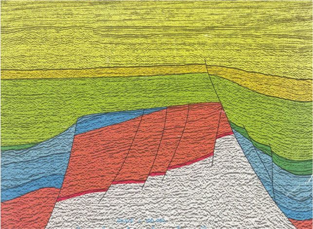
                   Figure 6. Three regional west-east–striking (dip) cross sections across the North Sea rift system illustrate the basin’s three main (pre-, syn-,
                   and postrift) tectono-stratigraphic megasequences. The main rift-related platform-graben structural domains such as the Shetland platform,
                   the East Shetland Basin, the Viking Graben, the Horda platform and Norwegian shelf, Utsira high, Stord Basin, Western platform, Western
                   trough, Forties Montrose high, Eastern trough, Jaeren high and Egersund Basin are all highlighted. The cross sections serve to illustrate
                   how migration out from the stratigraphically younger, but structurally deeper Upper Jurassic (synrift) source rock can fill-and-spill into rota-
                   tional fault blocks housing prerift reservoirs, their synrift counterparts in half-graben hanging-wall depocenters and into reservoirs belonging to
                   the typical “steer’s horn” postrift section too.

                                                                                                                                                                               UNDERHILL        AND      RICHARDSON                                           585
Downloaded from http://pubs.geoscienceworld.org/aapgbull/article-pdf/106/3/573/5542947/bltn20084.pdf
by guest
and Middle Jurassic occurs in the Inner Moray Firth,                                                The creation of oceanic crust between Greenland
          where it cosourced waxy crude found in the Beatrice                                          and northwestern Europe during the Eocene, com-
          field and its satellites.                                                                     bined with the effects of Tethyan (Alpine and Pyre-
               The development of the Atlantic Ocean had a pro-                                        neean) collision (Ziegler, 1987), has led to additional
          found effect on the northwestern European shelf in                                           phases of compressional on the Atlantic margin (e.g.,
          general and the North Sea in particular. Cretaceous                                          Tuitt et al., 2010) and in the neighboring plate interiors
          extension linked to the northeastward propagation                                            thereafter. Numerous Mesozoic Basins experienced
          and eventual onset of sea-floor spreading in the north                                        basin inversion with the formation of major anticlines
          Atlantic Ocean in the early Eocene led to a series of                                        as a consequence (e.g., the Wessex Basin [Colter and
          northeast-southwest–striking sedimentary basins                                              Harvard, 1981; Underhill and Paterson, 1998; Under-
          being formed, the most notable of which is the                                               hill and Stoneley, 1998], the Weald Basin [Butler and
          Faroe-Shetland Basin (Lamers and Carmichael,                                                 Pullan 1990], the Cleveland Basin, and in the southern
          1999). Although that basin is also prospective and con-                                      North Sea [e.g., Glennie and Boegner, 1981; Ziegler,
          tains the largest single oil pool in the United Kingdom                                      1982, 1990a, b; Van Hoorn, 1987; Badley et al.,
          in the 7 billion bbl Clair field (Coney et al., 1993; John-                                   1989]). Although the North Sea appears to have
          ston et al., 1995; Witt et al., 2010), it has a distinctive                                  escaped the most significant effects of the deformation,
          structural history and its total volumes fall well short of                                  it is still characterized by punctuated subsidence, local-
          those in the North Sea.                                                                      ized uplift, and fault reactivation.
               The Magnus field represents an example of a struc-
          ture lying in the North Sea Rift Super Basin that                                            The Overprint and Impact of Climate
          resulted from the postdepositional footwall uplift of                                        Change, Continental Drift, and Eustasy
          Upper Jurassic deep-water clastic reservoirs driven
          by Cretaceous extension. The far-field effects of Atlan-                                      Although the aforementioned tectonic history and
          tic rifting also drove structural inversion during the                                       consequent sedimentary responses are significant, it is
          Lower Cretaceous and the formation of anticlinal traps                                       important to underline that the changing pattern of
          during the Lower Cretaceous including those contain-                                         crustal fragmentation and reunification occurred
          ing prospective Upper Jurassic (synrift) clastics of the                                     against a backdrop of an overall slow northward passive
          Brae trend in the South Viking Graben.                                                       drift of the continents with consequences for climate.
               The subsequent development of the Iceland hot-                                          This drift took the North Sea area from south of the
          spot, the northward propagation of the North Atlantic,                                       equator prior to the Carboniferous to its present loca-
          and instigation of sea-floor spreading between north-                                         tion over halfway from the equator to the northern
          western Europe and Greenland have all impacted the                                           pole (Habicht, 1979; Smith et al., 1981). The inexora-
          North Sea. The inception of the mantle plume led to                                          ble northward-drift had a pronounced effect on fauna
          the creation of the North Atlantic Large Igneous Prov-                                       and on sedimentation as the area passed through suc-
          ince (Mussett et al., 1988) and significant igneous                                           cessive latitudes and climatic belts.
          underplating of the continental crust. Underplating                                               The development of major ice sheets in the polar
          led to Cenozoic exhumation of large parts of the British                                     regions provided an additional impact on climate
          Isles and punctuation of the postrift subsidence by                                          that modified the effects of Britain’s northerly drift.
          periods of uplift in western areas (Nadin et al., 1995)                                      During the Phanerozoic, the Earth’s climate appears
          that is particularly well documented in the western                                          to have oscillated between a state of global warming
          part of the North Sea rift (the Inner Moray Firth; Hillis                                    and incubation (“greenhouse conditions”) and one of
          et al., 1994; Thomson and Underhill, 1993), where                                            global cooling and refrigeration during which ice sheets
          progressively older subcrop patterns occur (Guari-                                           grew and dominated the poles (“icehouse conditions”).
          guata-Rojas and Underhill, 2017). The associated fault                                       In total, seven oscillations appear to have occurred
          reactivation also added to the structural complexity                                         with greenhouse conditions prevailing during the early
          and was largely detrimental to petroleum prospectivity                                       Cambrian–Late Ordovician (570–458 Ma), early
          (Argent et al., 2000) and affects the carbon storage                                         Silurian–early Carboniferous (428–333 Ma), and late
          potential of saline aquifers in the area (Guariguata-                                        Permian–early Cenozoic (258–55 Ma). Conversely,
          Rojas and Underhill, 2017).                                                                  icehouse climate affected the late Proterozoic–early

          586                The North Sea Rift Super Basin
Downloaded from http://pubs.geoscienceworld.org/aapgbull/article-pdf/106/3/573/5542947/bltn20084.pdf
by guest
Phanerozoic (800–570 Ma), Late Ordovician–early                                     (Draupne) and Heather Formations, which form com-
                   Silurian (458–428 Ma), early Carboniferous–late                                     ponent parts of the Humber (Viking) Group (Barnard
                   Permian (333–258 Ma), and early Cenozoic onward                                     and Cooper, 1981; Chung et al., 1992; Cornford,
                   (55 Ma to the present day).                                                         1998; Isaksen et al., 2002). Deposition of the Upper
                       Several factors also combined to control global                                 Jurassic source intervals was contemporaneous with
                   (eustatic) sea levels through the Phanerozoic, but                                  Upper Jurassic synrift fault activity and their gentle
                   they were particularly responsive to changes in the                                 (postrift) subsidence led to thermal maturation and
                   size of ocean basins resulting from variations in                                   petroleum migration occurring from the early Ceno-
                   sea-floor spreading rates, periods of continental defor-                             zoic to the present day. The effect was to set up a highly
                   mation, and times of high sediment supply. In combi-                                efficient petroleum system in the North Sea Basin,
                   nation, climate and eustasy influenced the nature of                                 whereby extensional fault blocks created traps con-
                   sedimentation by determining the extent to which                                    taining reservoir-seal pairs that received its petroleum
                   continental land masses were flooded, the depth of                                   charge from neighboring kitchen areas (Goff, 1983;
                   water in oceans and the degree of water circulation                                 Burley, 1993).
                   within and between basins. The variation in global                                        Although the Upper Jurassic sources dominate,
                   sea level has largely mirrored the climate through                                  there is a recognition from geochemical analyses that
                   time as exemplified by the glacio-eustatic cyclothems                                other sources also contribute to some fields. High total
                   that controlled Carboniferous deposition and Late                                   organic carbon characterizes parts of the Lower Juras-
                   Cretaceous warming that drove global sea levels to                                  sic (Dunlin and Lias Groups), Permian (Zechstein
                   their highest levels during the Phanerozoic with the                                Group), Carboniferous (Dinantian and Namurian)
                   creation of marine seaways and chalk deposition over                                Bowland Shale, and the Middle Devonian sedimentary
                   large areas of the continental interior.                                            sequences. Additional source intervals include the
                                                                                                       Middle Jurassic Sleipner and Brora Coal Formations,
                                                                                                       the upper Carboniferous (Pennsylvanian) Coal Meas-
                   THE NORTH SEA RIFT’S PETROLEUM SYSTEM                                               ures Group, the lower Carboniferous (Mississippian)
                                                                                                       Scremerston Coal Group of northeastern England,
                   A petroleum system encompasses all of the essential                                 the West Lothian Oil Shale in the Midland Valley of
                   elements (source, reservoir, seal, and overburden                                   Scotland (Underhill et al., 2008), and the Middle
                   rock) processes (trap formation, generation-migra-                                  Devonian lacustrine (fish-bearing) Eday Shale clay-
                   tion-accumulation) and all genetically related petro-                               stones of the Orcadian Basin. The latter makes a signif-
                   leum that originated from one pod of active source                                  icant contribution in western parts of the Moray Firth
                   rock and occurs in shows, seeps, or accumulations                                   rift, where Upper Jurassic source intervals are too shal-
                   (Magoon and Dow, 1994). The geographical extent                                     low and cool to be mature, creating a petroleum system
                   of a petroleum system is commonly delineated by a                                   that charges the Beatrice field and its satellites (Peters
                   line within which all fields, discoveries, shows, and                                et al., 1989). The occurrence of the waxy lacustrine
                   seeps ascribed to a specific source rock occur. The fol-                             source rocks even necessitated the construction of a
                   lowing sections describe the key elements of the North                              dedicated refinery at Nigg to handle the waxy crude
                   Sea rift’s petroleum system and the controls on its main                            derived from the Middle Devonian source rocks.
                   reservoir play fairways. Comparison between the three
                   rift arms highlights significant differences in the distri-                          Sedimentary Play Fairways
                   bution of the prospective reservoirs, the controls on
                   which we will attempt to explain.                                                   Paleozoic and Older Reservoirs
                                                                                                       A variety of upper Paleozoic and older rock formations
                   Source Rocks                                                                        host petroleum in several parts of the North Sea
                                                                                                       (Figure 7), albeit without forming any giant fields in
                   The key to the success of any petroleum province is the                             their own right. Their distribution is almost exclusively
                   occurrence and maturity of an extensive, thick, and                                 confined to upstanding areas lying on the graben flanks
                   rich source rock. In the North Sea rift, pride of place                             or in intrabasinal horst blocks, especially those that lie
                   goes to source horizons within the Kimmeridge Clay                                  within the inner confines of the uplift resulting from

                                                                                                                              UNDERHILL   AND   RICHARDSON   587
Downloaded from http://pubs.geoscienceworld.org/aapgbull/article-pdf/106/3/573/5542947/bltn20084.pdf
by guest
You can also read