Geologia Marina Anno accademico 2017 2018 - Moodle@Units
←
→
Page content transcription
If your browser does not render page correctly, please read the page content below
Corso di Geologia Marina 2017-18

         Università di Trieste
LAUREA MAGISTRALE IN GEOSCIENZE
        Curriculum Geofisico
  Curriculum Geologico Ambientale

   Anno accademico 2017 – 2018

    Geologia Marina

   Modulo 6.X Jurisdiction at sea

         Docente/Lecturer:
      Angelo Camerlenghi (OGS)
            Daniel PRAEG
        OGS & Géoazur, Nizza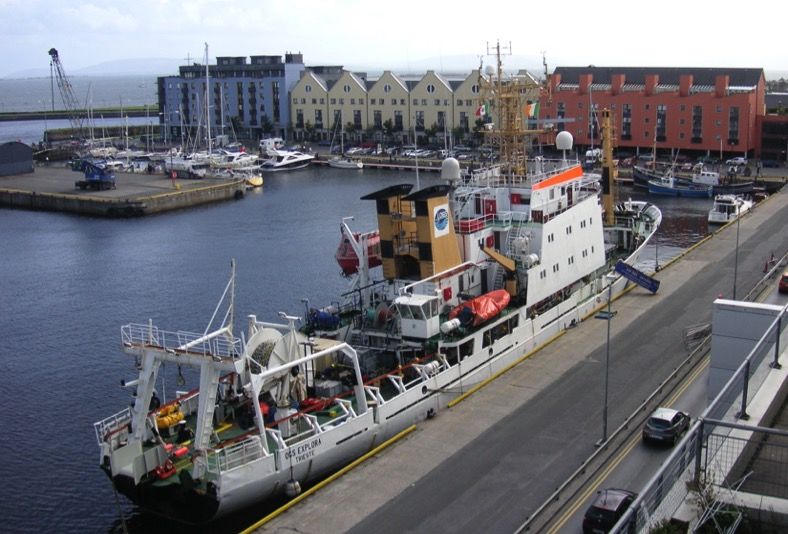
Corso di Geologia Marina 2017-18

Two ways to see the world :
Pure Research (Natural SCIENCE)
• Exploring the ‘blue planet’ - 71% oceans
• Onshore geology dominated by submarine deposits
• ‘No geology without marine geology’ (Kuenen 1958)
• To understand how the Earth works (in the past,
  present and future), we need to study what goes on

                                                                                 Sources: Wikimedia commons
  in and beneath the oceans over time

Applied Research (Natural R€$OURC€$)
• Using the seabed (for cables, pipelines, platforms…)
• Exploring for opportunities (solid, liquid & gas)
• All offshore activities require some understanding of
  how the Earth works, for exploration/exploitation
• In turn, an important driver for pure research activity
  (both technologically and financially)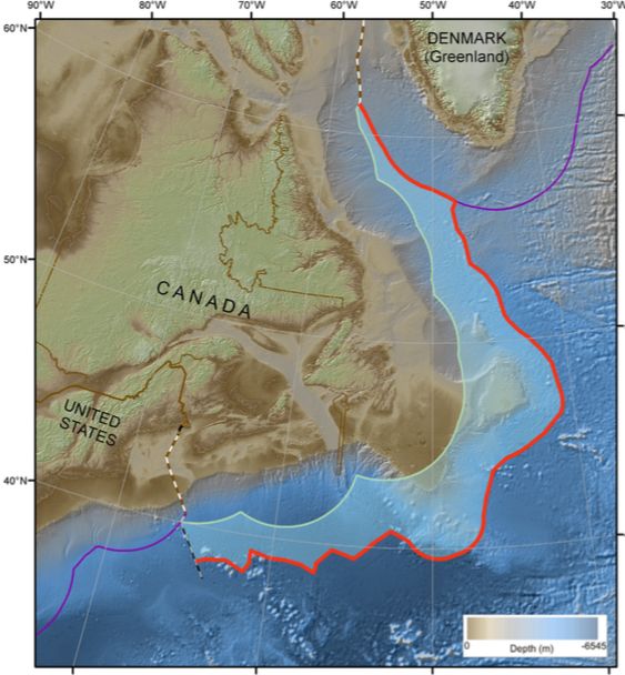
Corso di Geologia Marina 2017-18

    Ø Working at sea is expensive - vessels cost 10,000-100,000€/day
OGS Explora: a publicly-funded research vessel
•     acquired by OGS in 1989, only ocean-going ship owned by a research institute
•     scientific campaigns worldwide (from Antarctica to the Arctic)
              • € 106/year from Italian government for use & maintenance

       OGS Explora in                                                               Operating costs
       Galway harbour,                                                              offshore :€15-
          Ireland, 2009                                                             25,000/day In
    (International Polar                                                            port :€6-
        Year campaign)                                                              10,000/day)

                            Secondary activity: commercial service work
                            •   contracted to offshore companies (e.g. Fugro)
                            •   geophysical/geological surveys (e.g. cables, exploration…)
                            •   return to origins: originally a Geco-Prakla seismic boat (1973-1989)
Corso di Geologia Marina 2017-18

OUTLINE
• The Law of the Sea – who owns what?
                                          discussion / pause
• Offshore (geo-) economic activities
   o   Submarine cables & pipelines                   Seabed installations,
   o   Renewable energies (wind farms)                    old & new
   o   Seabed mapping (a service industry)
   o   Nearshore sand and gravel mining
   o   Deep sea mineral mining
                                                             Natural
   o   Bio-prospecting (sub-seabed)                        resources,
   o   Hydrocarbon exploration                            nearshore to
   o   Methane hydrates?                                    deep-sea

• Career paths for (potential) young marine geoscientists
         what kind of activity might interest you?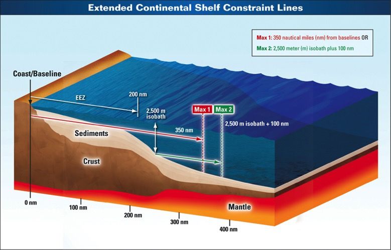
Corso di Geologia Marina 2017-18

WHO OWNS THE SEAS?
Roman Empire : Mare nostrum (Mediterranean), based on control of
 surrounding coasts; seas not territorial, i.e. not ‘owned’
Republics of Venice, Genoa : local forms of Mare clausum: in parts of
  Mediterranean, control of shipping by military force
15-16th centuries : Mare clausum – Age of Discovery, Iberians claim
  vast areas of globe --> conflict with French, Dutch, British…
17th century : Mare liberum (Hugo Grotius 1609)
  > the High Seas are the common property of all…
18th century: codified by Bynkershoek in
     De dominio maris (1702) :
  > coastal waters = one cannon shot = 3 nautical miles

                                                                                 Source of images:
                                                                                Wikimedia commons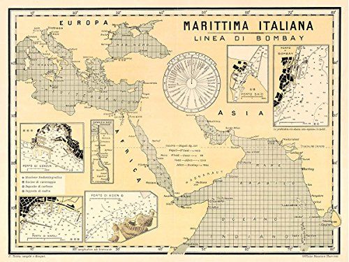
Corso di Geologia Marina 2017-18

Nautical Miles
 Earth divided into 360°, equator to pole 90°
 Each degree divided into 60 minutes

 1 nautical mile = 1 minute of latitude                                                               Source of
                                                                                                       image:
               (= 1843 m at the equator,                                                              Wikimedia
                                                                                                      commons
                 1861 m at the poles,
                 mean length 1852.216 m)

 1 International Nautical Mile = exactly 1852 m

  http://moblog.whmsoft.net                     http://www.sailingissues.com   http://www.coastalnavigation.com/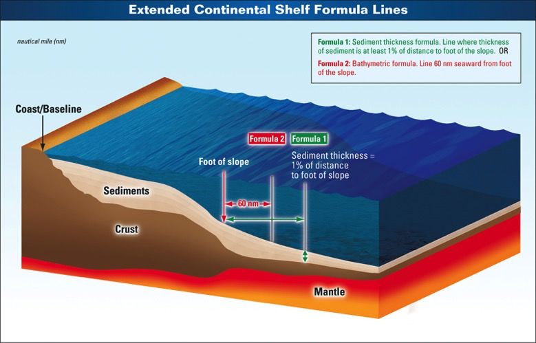
Corso di Geologia Marina 2017-18

WHO OWNS THE SEAS?
19-20th centuries (ever bigger cannons …)
• Mare liberum respected by most nations – ‘territorial’ seas to 3 nm,
  Spain to 6 nm (although control of high seas disputed during wars)
• Growing interest in marine resources (mineral, but mainly biological)

1945 : something new (from the USA)
• Presidential Proclamations (2667, 2668) established jurisdiction
  and control of natural resources & fisheries in high seas adjacent
  to the coastline, across the ‘Outer Continental Shelf’       See http://www.trumanlibrary.org/proclamations/index.php

• Many nations responded, extending their territorial waters to 12 nm
  (eastern Europe, Middle East) or even to 200 nm (Peru, Ecuador, Chile)

1947: 1st offshore oil platform (Gulf of Mexico,  added to agenda the question of determining legal extent of offshore waters
Corso di Geologia Marina 2017-18

United Nations Convention on the Law of the Sea
= UNCLOS
• based on a series of international conferences from 1958-1982
• convention in force since 1994 (when 60th signatory ratified)
• not a law, but a treaty currently ratified by 166 parties plus the European Union
• one of the longest treaties in history – 320 articles + 9 annexes
• addresses many issues:
  navigation, piracy, pollution,
  conservation, scientific
  exploration, economic rights…
• Mare liberum or freedom of
  the seas replaced by
  internationally agreed rules

                                                                                                                         Sources: Wikimedia commons
                                         http://www.un.org/depts/los/convention_agreements/texts/unclos/UNCLOS-TOC.htm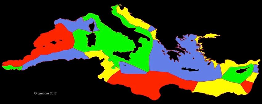
Corso di Geologia Marina 2017-18

UNCLOS & CONTROL OF NATURAL RESOURCES
• extends national jurisdiction of biological and mineral resources
  seaward to the edge of ‘the Continental Shelf’:
   Ø Article 77.1 : The coastal State exercises over the
     continental shelf sovereign rights for the purpose of
     exploring it and exploiting its natural resources.
   Ø 77.4: The natural resources referred to … consist of the
     mineral and other non-living resources of the seabed
     and subsoil together with living organisms belonging to
     sedentary species… unable to move except in constant
     physical contact with the seabed or the subsoil.

• creates a series of defined maritime zones, Exclusive
  Economic Zone (EEZ) extends to 200 nms, beyond
  which is the ‘Continental Shelf’…
• beyond the Shelf, international jurisdiction and
  management of the resources of The Area (Part XI)
                                                                                     Sources: Wikimedia commons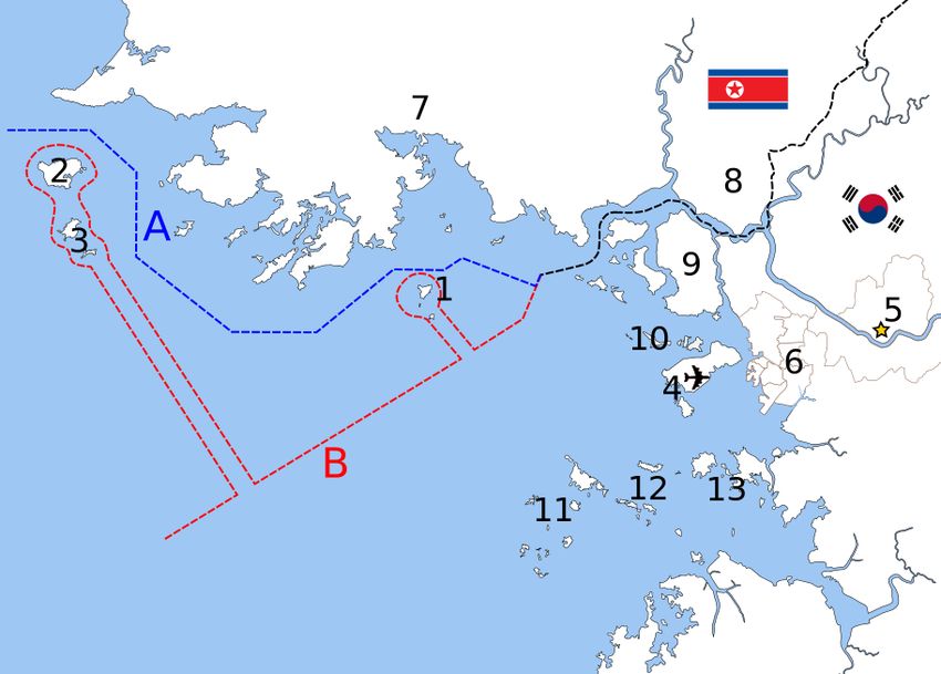
Corso di Geologia Marina 2017-18

UNCLOS MARITIME ZONES
•   Baseline = low water line (or straight line between headlands)
•   3 nm = Coastal Waters (one cannon shot…)

                                                                                                  Sources: Wikimedia commons
•   12 nm = Territorial Seas (right of ‘innocent passage’)     National control of resources
•   24 nm = Contiguous Zone (zone of ‘hot pursuit’)                in & beneath the seas
•   12-200 nm = Exclusive Economic Zone (EEZ)
•   12-350 nm or more = Continental Shelf                       National control of resources
                                                                            at & beneath seabed

                             International Waters

• Beyond: The Area                                                      Internationally managed
Corso di Geologia Marina 2017-18
The Exclusive Economic Zone (EEZ)
• Simple definition: extends up to 200 nm
offshore (from a baseline)
• International waters, in which coastal
nation has rights to all resources in and
Sources: Wikimedia commons
beneath the seas
• Contains 99% of world’s fisheries, and
>80% of hydrocarbon reserves
(see http://www.eoearth.org/view/article/156775)
Nonetheless, there are disputes
• Where nations areCorso di Geologia Marina 2017-18
Examples of EEZ disputes :
Canada vs France (Saint-Pierre-et-Miquelon) The two Koreas (unresolved…)
RESOLVED
Sources: Wikimedia commons
1999Corso di Geologia Marina 2017-18
Mediterranean EEZs
Example:
One possible representation of Mediterranean maritime jurisdictions
(Suarvez de Vivero 2007) (http://www.guidopicchetti.it - UNEP-MAP, The Mediterranean Sea)
Sources: Wikimedia commons
Consequence: increasing difficult for
research vessels to conduct
international surveys in eastern Med
(e.g. myself offshore Egypt in 2007,
Greece-Turkey 2014)Corso di Geologia Marina 2017-18
A Mediterranean EEZ continuing dispute :
http://en.wikipedia.org/wiki/Croatia%E
2%80%93Slovenia_border_disputes
Since 1992, based on differing interpretations of UNCLOS Note that EEZ
and Slovenian wish for access to International waters) disputes do not
involve geologyCorso di Geologia Marina 2017-18
Shelf break depths
The ‘Continental Shelf’ typically 200-500 m
• To a geologist, the continental
shelf (la piattaforma continentale)
is a physiographic feature, based
on geomorphology and geology
• For UNCLOS, the continental shelf mixes geology with a legal concept -
a ‘natural prolongation of land areas’ in which a coastal nation has
exclusive rights to mineral and biological resources (Article 76)
• The Continental Shelf lies beneath
the EEZ (200 nm) and extends past it International Waters
as the ‘Extended Continental Shelf’
(ECS) to at least 350 nm
• ECS may extend well beyond the
geological platform, but geology is
still used to define it…Corso di Geologia Marina 2017-18
‘Extended Continental Shelf’
Limits Defined
UNCLOS Article 76 :
• criteria of geomorphology and
geology used to define…
Formula lines
(maxima?)
Constraint lines
(minima?)
Each in any combination; used
together to define (maximise) the
Extended Continental Shelf (ECS)
US Extended Continental Shelf Project,
http://www.continentalshelf.gov/)Corso di Geologia Marina 2017-18
Extended Continental Shelf claims
• Based on submissions to the UN Commission on the Limits of the
Continental Shelf (CLCS), within 10 years of ratifying UNCLOS
• Require supporting information on:
Ø bathymetry (multibeam sonar data)
Ø sediment thickness (seismic profiles)
Source: http://continentalshelf.gov/
• Preparation of ‘Law of the Sea claims’ can
mean national funding for marine
geoscience (e.g. USA, Canada, Australia…)
• OGS Explora has been contracted to acquire
data for Canada’s ECS program
EEZ ECS
Partial submission of Canada to the CLCS
regarding its continental shelf in the
Atlantic Ocean, 2013
(precedes submission on Arctic shelf) Submitted limits of the ‘Extended
Continental Shelf’ of Atlantic CanadaCorso di Geologia Marina 2017-18
Extended Continental Shelf claims also lead to disputes…
‘The race for the Arctic’
(The Economist, 14 May 2009)
• A race for control of resources,
arbitrated through the UN via
submissions to the CLCS
• A slow race: within 10 years of
ratifying UNCLOS, many still in
preparation (joined at different
times, or not joined yet – USA)
• Arctic disputes have made the
news (e.g. North Pole), but
over relatively small areas…
• Versus national jurisdiction of
almost the entire Arctic Ocean
(and its resources)
Source: The Economist, 14 May 2009Corso di Geologia Marina 2017-18
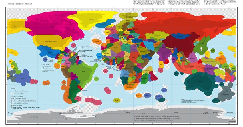
One way to see EEZs : ‘a rock in the ocean = 430,000 km2 exploitable surface offshore’
(Theo Deutinger)
Source: http://td-architects.eu (2009)
EEZs represent approximately 1/3 of the oceans (or 1/4 of the planet)
an ‘invisible global chessboard’ for control of world’s natural resourcesCorso di Geologia Marina 2017-18
Beyond the ECS and national jurisdiction lies…
‘The Area’ = more than 50% of the Earth’s surface
• International jurisdiction
UNCLOS Preamble & Part XI :
…the seabed and ocean floor and the subsoil thereof, beyond the limits of national
jurisdiction, as well as its resources, are the common heritage of mankind…
• ‘freedom of the seas’ replaced by the international management of marine resources
• called for wealth and technology transfers from developed to undeveloped nations
International Seabed Authority (ISA), Jamaica
founded
1994
Opposed and weakened by developing nations e.g. USA (‘market forces…’)
ISA retains control over geo-resources (mining)
Being (con)tested in regard to bio-prospecting
Publications: T. Scovazzi (2004, 2006), Prof of Intl Law, Milano-BicoccaYou can also read