EVIDENCE OF REPEATED WILDFIRES PRIOR TO HUMAN OCCUPATION ON SAN NICOLAS ISLAND, CALIFORNIA
←
→
Page content transcription
If your browser does not render page correctly, please read the page content below
Monographs of the Western North American Naturalist 7, © 2014, pp. 35–47

               EVIDENCE OF REPEATED WILDFIRES PRIOR TO HUMAN
                OCCUPATION ON SAN NICOLAS ISLAND, CALIFORNIA
                   Jeffrey S. Pigati1,3, John P. McGeehin2, Gary L. Skipp1, and Daniel R. Muhs1

    ABSTRACT.—Understanding how early humans on the California Channel Islands might have changed local fire
regimes requires a baseline knowledge of the frequency of natural wildfires on the islands prior to human occupation. A
sedimentary sequence that was recently discovered in a small canyon on San Nicolas Island contains evidence of at least
24 burn events that date to between ~37 and 25 ka (thousands of calibrated 14C years before present), well before
humans entered North America. The evidence includes abundant macroscopic charcoal, blackened sediments, and dis-
crete packages of oxidized, reddish-brown sediments that are similar in appearance to sedimentary features called “fire
areas” on Santa Rosa Island and elsewhere. Massive fine-grained sediments that contain the burn evidence are inter-
preted as sheetwash deposits and are interbedded with coarse-grained, clast-supported alluvial sediments and matrix-
supported sands, pebbles, and cobbles that represent localized debris flows. These sedimentary sequences suggest that
the catchment area above our study site underwent multiple cycles of relative quiescence that were interrupted by fire
and followed by slope instability and mass wasting events. Our 14C-based chronology dates these cycles to well before
the arrival of humans on the Channel Islands and shows that natural wildfires occurred here, at a minimum, every
300–500 years prior to human occupation.

    RESUMEN.—Entender cómo los primeros habitantes humanos de las Islas del Canal de California podrían haber
cambiado los regímenes de incendios locales, requiere de un conocimiento básico de la frecuencia de incendios fore-
stales naturales en las islas antes de la ocupación humana. Una secuencia de sedimentación que se descubrió reciente-
mente en el pequeño cañón de la Isla de San Nicolás contiene pruebas de al menos 24 incendios que datan de entre
~37 y 25 ka (miles de calibrados 14C años antes del presente), mucho antes de que los humanos llegaran a
Norteamérica. Las pruebas incluyen abundantes carbones macroscópicos, sedimentos carbonizados y paquetes discretos
de sedimentos oxidados de color rojo-marrón que se parecen a los rasgos sedimentarios llamados “áreas de incendio” de
la Isla Santa Rosa y otros lugares. Enormes sedimentos de grano fino que contienen pruebas de incendios se interpretan
como depósitos de erosión laminar, y están intercaladas con sedimentos aluviales, apoyados por clastos de grano grueso
y con arenas, guijarros y rocas soportados por la matriz, que representan corrientes de sedimentos localizados. Estas
secuencias sedimentarias sugieren que el área de captación del sitio de estudio sufrió múltiples ciclos de relativa inac-
tividad interrumpidos por el fuego y seguidos por inestabilidad de la ladera y eventos de remoción en masa. Nuestra
cronología basada en 14C, sitúa con certeza estos ciclos mucho antes de la llegada de humanos a las Islas del Canal, y
demuestra que ocurrieron incendios forestales naturales, como mínimo, cada 300–500 años antes de la ocupación
humana.

   Sedimentary charcoal is relatively common                                Erlandson et al. 2012, Rick et al. 2012). How-
in the Quaternary record on the California                                  ever, assessing the role that humans have had
Channel Islands. Previous researchers have                                  in the fire history of the islands is made diffi-
found charcoal in paleosols, eolian and alluvial                            cult by the fact that both natural (lightning-
sequences, and sediment cores dating to the                                 induced) and anthropogenic fires leave behind
late Pleistocene and Holocene on Santa Rosa,                                similar evidence in the geologic record, espe-
San Miguel, and Santa Cruz islands, among                                   cially during times when human populations
others (Orr 1968, Johnson 1977, Cole and Liu                                are relatively low.
1994, Anderson et al. 2009, Pinter et al. 2011b,                               On mainland North America, humans have
Scott et al. 2011). For decades, researchers                                used fire since at least the late Pleistocene to
have been interested in understanding fire                                  clear land for cultivation, remove underbrush,
regimes on the Channel Islands and the role                                 drive or trap game, and alter plant communi-
early humans might have had in using fire to                                ties (Greenlee and Langenheim 1990, Keeley
transform the island landscapes (Orr 1968,                                  2002, Bowman et al. 2009). Evidence for such
Kennett et al. 2008, Pinter et al. 2011a,                                   activities goes back even further in time in
   1U.S. Geological Survey, Denver Federal Center, Box 25046, MS-980, Denver, CO 80225.
   2U.S. Geological Survey, 12201 Sunrise Valley Drive, MS-926A, Reston, VA 20192.
   3E-mail: jpigati@usgs.gov

                                                                       35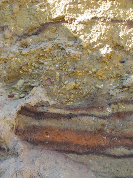
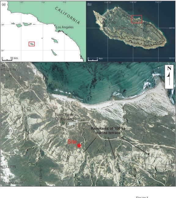
36                    MONOGRAPHS OF THE WESTERN NORTH AMERICAN NATURALIST                                      [Volume 7

   Fig. 1. Reference maps: a, location of San Nicolas Island (denoted by red box), off the coast of California; b, topography
of San Nicolas Island (the catchment area for Chukar Canyon includes a portion of the >250-m area near the center of
the island); c, site location and local topography for the Chukar Canyon section.

Africa, Europe, Asia, and Australia, where evi-                 per decade in areas below ~200-m elevation,
dence of fire in the geologic record often coin-                with only 2%–5% of those strikes resulting
cides with the onset of human occupation                        in wildfires (Minnich et al. 1993, Wells and
(Brown et al. 2009, Mooney et al. 2011, Roe-                    McKinsey 1995). In the recent geologic past,
broeks and Villa 2011, Archibald et al. 2012,                   particularly during the late Pleistocene, cooler
Berna et al. 2012). Thus, in ecosystems that                    temperatures and increased moisture would
are susceptible to burning but where ignition                   have limited the number of natural fires even
sources are limited (such as a low-relief island                more (Heusser 1995, Daniau et al. 2012).
in a Mediterranean climate), the arrival of hu-                 Therefore, California’s coastal region and the
mans could potentially create a significant                     Channel Islands may have been especially
change in the local fire regime.                                sensitive to the introduction of a novel ignition
   Today, low-lying areas in coastal southern                   source when humans first arrived. Physical and
California have one of the lowest lightning-                    chronologic evidence from Arlington Canyon
induced fire frequencies in North America due                   on Santa Rosa Island shows that humans have
to a general lack of convective storms in the                   been present on the islands since at least 13 ka
summer and high fuel-moisture content in                        (thousands of calibrated 14C years before pres-
the winter (Junak et al. 1995, Keeley 2002).                    ent; Orr 1968, Johnson et al. 2002, Stafford et
In San Diego County, for example, the Bureau                    al. 2008). Thus, to determine the frequency
of Land Management’s Automated Lightning                        of natural wildfires on the islands, we must
Detection System has recorded, on average,                      examine evidence of fire in sediments that date
only one lightning strike per square kilometer                  to before this time period (Bowman et al. 2011).
2014]                         WILDFIRES ON SAN NICOLAS ISLAND                                     37

    Charcoal from the Channel Islands has          marine sandstones and siltstones, with minor
been recovered from Holocene-age sediment          amounts of interbedded conglomerate and
in cores taken on Santa Rosa Island (Cole and      pebbly mudstone (Vedder and Norris 1963).
Liu 1994, Anderson et al. 2009), and isolated      Numerous marine terraces are present between
fragments of charcoal dating to the late Pleis-    the modern shoreline and the upper reaches
tocene have been reported from Santa Rosa          of the island, reflecting episodes of tectonic up-
Island (Orr 1968, Pinter et al. 2011b, Scott et    lift that have occurred for at least the past half
al. 2011) and San Miguel Island (Johnson           million years (Muhs 1985, Muhs et al. 2012).
1977). Farther afield, charcoal has been recov-        Deeply incised canyons drain the outer parts
ered from core ODP 893 in the Santa Barbara        of the island, including a canyon on the north
Basin, although this finding probably reflects     side that we refer to informally as “Chukar
burn events on the California mainland more        Canyon” because of the large number of par-
than the islands themselves (Heusser and           tridges (Alectoris chukar) that were present
Sirocko 1997). Thus far, there have not been       during each of our site visits. The catchment
any published reports of a continuous se-          area of Chukar Canyon represents one of the
quence of late Pleistocene sediments any-          largest drainages on the island and includes a
where on California Channel Islands that           portion of the island’s highest mesa-like re-
contains charcoal, spans several centuries or      gion: a broad, nearly flat landscape dominated
millennia and dates to >13 ka.                     by old marine terraces and located in the cen-
    In this study, we describe a sedimentary       tral part of the island (Fig. 1b). Vegetation in
sequence that was recently discovered in a         the catchment area today consists largely of
small canyon on the north side of San Nicolas      coastal scrub, sparse grassland, and abundant
Island. The sequence contains abundant char-       tickseed (Coreopsis; Junak et al. 1995).
coal, spans several millennia, and dates to well       Chukar Canyon is incised into Eocene bed-
before the arrival of humans. It also contains     rock approximately 1 km south of the site be-
several discrete packages of discolored sedi-      fore it descends from the mesa’s edge, cutting
ments that are consistent with fire areas that     through alluvium and a 100-ka marine terrace
have been documented on Santa Rosa Island,         just above the study site (Muhs et al. 2012).
San Miguel Island, Santa Cruz Island, and, to      Adjacent to a U.S. Navy facility outbuilding,
a lesser extent, mainland California (Orr and      resistant bedrock forces the drainage to turn
Berger 1966, Orr 1968). Combined, these fea-       east/southeast at a sharp angle before redi-
tures provide an unusual opportunity to quan-      recting northward and ultimately reaching the
tify the frequency of natural wildfires on San     Pacific Ocean (Fig. 1c). At this bend, a ~5-m
Nicolas Island and establish a baseline for        thick sedimentary sequence that contains
evaluating the impact of anthropogenic fires       abundant macroscopic charcoal, blackened
during the early stages of human occupation        sediments, and discrete packages of discolored
on the Channel Islands.                            red and dark brown sediments is preserved
                                                   in the canyon walls (Fig. 2). After working in
                 STUDY AREA                        Chukar Canyon, we surveyed every canyon of
                                                   significant size on San Nicolas Island (>35 in
    San Nicolas Island is a small (~58-km2),       all) but did not find either a similar package
remote island located approximately 100 km         of alluvial sediments or clear evidence of re-
from mainland California (Fig. 1a). As one of 8    peated fire events in any of the other canyons.
islands that compose the California Channel
Islands, San Nicolas Island is separated from                         METHODS
Santa Barbara Island, its nearest neighbor, by
45 km of open ocean. Notably, San Nicolas             In the field, we set up a 1 × 1-m grid over
Island was not connected with the other is-        sediments exposed in Chukar Canyon for de-
lands or the mainland during the late Pleis-       scription and sampling purposes. Some of the
tocene, even when sea level was ~90 m lower        sediments were covered or obviously slumped,
than modern during the Last Glacial Maximum        but most were well exposed and in their origi-
(Muhs et al. 2012). The island is relatively low   nal depositional positions. We identified at
and flat (the maximum elevation is only 277 m      least 24 layers that we called “burn zones”
asl), and bedrock consists primarily of Eocene     based on darkening or discoloration of the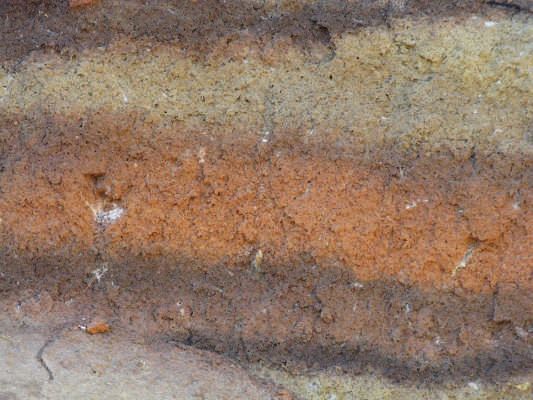
38 MONOGRAPHS OF THE WESTERN NORTH AMERICAN NATURALIST [Volume 7
paleosol
Pigati et al - SNI fire manuscript
Figure 2 (revised)
11
31.85±0.73
BZ22
23
10
BZ17
BZ18
BZ23
BZ24
9
slump
34.78±0.87
covered
8
21
36.8±1.5
19
7
31.01±0.37
BZ16
BZ19
32.80±0.97
BZ21
BZ20
BZ9
6
20
10
31.15±0.22
BZ12
81
BZ10
slump
32.98±0.94
5
8
9
30.36±0.59
BZ11
BZ15
BZ13
4
31.94±0.77
25.07±0.59 (r)
24.88±0.42
BZ14
5
3
C sample location
31.19±0.40
2
17
slump
debris flow
burn zone
active soil
2
silt/clay
BZ3
BZ1
BZ8
29.10±0.38
BZ7
14
slump
14
BZ2
9
1
depth scales
BZ5
(in meters)
BZ4
BZ6
lateral &
0
1
2
3
4
5
6
Fig. 2. Stratigraphy of the Chukar Canyon section. Ages in the yellow boxes are given in ka (thousands of calibrated
14Cyears before present). Burn zone numbers are shown in bold (marked BZ), and sample numbers are shown in italics.
sediments along with macroscopic fragments laboratory in Reston, Virginia, for radiocarbon
of charcoal associated with many of the dis- (14C) dating. There, charcoal samples were
colored zones. Charcoal was picked from several subjected to the standard acid-base-acid
of the burn zones in the field and was submitted (ABA) treatment and were combusted to CO2
to the U.S. Geological Survey’s radiocarbon under vacuum in the presence of CuO and Ag.
2014]                         WILDFIRES ON SAN NICOLAS ISLAND                                     39

The resulting CO2 was split into 2 aliquots.       corresponds to a 2q range of + – 0.04°. The CPS
One aliquot was converted to graphite by           data of the glycolated aliquot were taken from
using an iron catalyst and the standard hydro-     the expandable clay (smectite) peak (5.2°, 2q,
gen reduction process and was submitted to         17 Å), the mica/illite peak (8.8°, 2q, 10 Å), and
the Center for Accelerator Mass Spectrometry       the kaolinite-plus-chlorite peak (12.4°, 2q, 7.1
at Lawrence Livermore National Laboratory          Å) and were calculated as follows:
for AMS 14C analysis. The second aliquot was
submitted for δ13C analysis to correct the            E (expandables) = CPS at 5.2° 2q
measured 14C activity for isotopic fractiona-         I (mica/illite) = 3 × CPS at 8.8° 2q
tion. All 14C ages were calibrated using the          K (kaolinite plus chlorite) = 2 × CPS at
IntCal13 data set and CALIB 7.0 (Stuiver and             12.4° 2q
Reimer 1993, Reimer et al. 2013). Ages are            T (total) = E + I + K
presented in thousands of calibrated 14C years
BP (Before Present; 0 yr BP = 1950 AD), and        Two lines of evidence indicated that chlorite
uncertainties are given at the 95% (2σ) confi-     was absent from the Chukar Canyon sediments:
dence level.                                       (1) the 12.4° 2q peak collapsed after heating to
    We also collected samples of sediment from     550 °C, and (2) we did not observe a signifi-
within and adjacent to the burn zones for clay     cant peak at 18.7° 2q. Thus, we interpret the
mineralogy to determine whether these zones        12.4° 2q peak to represent only kaolinite in
were related to fire events. If the sediments      the samples analyzed here.
sampled were heated by fire during burial, for         Finally, clays recovered from 2 samples, BZ8-
example, clays that are sensitive to high tem-     3 and BZ8-4, were selected for step-heating
peratures (e.g., smectite and kaolinite) would     experiments to determine the highest tempera-
be either absent or present in lower concen-       ture the sediments were subjected to during
trations than in the adjacent, unheated host       burial. We reasoned that if the smectite or
sediment (Carroll 1970). In the laboratory,        kaolinite peaks remained unchanged during a
clays (
40                   MONOGRAPHS OF THE WESTERN NORTH AMERICAN NATURALIST                                     [Volume 7

 a                                                                Interbedded with these fine-grained de-
                                                              posits are discrete units up to ~1 m thick that
                                                              are coarse grained and poorly sorted. Some of
                                                              the coarse units are clast supported, which
                                                              we interpret as high-energy alluvial deposits;
                                                              whereas others are matrix supported, which
                                                              we interpret as localized debris flows (Fig. 3).
                                                              In both types of deposits, the large clasts are
                                                              subangular to subrounded, range up to 3–5 cm
                                                              in diameter, and are composed of the local
                                                              Eocene sandstones and siltstones. Both are
                                                              present in clearly defined channels and ex-
                                                              hibit sharp-to-clear contacts with the adjacent
                                                              fine-grained sediments.
 b                       overbank                                 The 24 burn zones that we identified in
                         deposits                             Chukar Canyon were all contained within the
                                                              fine-grained facies described above. The zones
           BZ 5                                               are lens-shaped or elongated and horizontal to
                                                              subhorizontal, and they range from ~20 cm to
                                                              nearly 5 m across. The burn zones exhibited
                                                              the same field texture and grain size as the
                                                              adjacent, unmodified sediments. Moreover, the
                                       debris flow            colors of the burn zones were dark reddish
                                       sediments              brown (5YR3/3) to reddish brown (5YR4/4)
                                                              near their centers, and graded into lighter, less
                                              overbank        oxidized colors toward their edges, then tran-
                                              deposits
                                                              sitioned entirely into the yellowish-brown
                                                              (10YR5/6) host sediment. Combined, these
  BZ 7                                                        features suggest that the burn zones were
                                                              formed in situ rather than as a result of pro-
                                                              cesses operating upstream followed by deposi-
                                BZ 8                          tion at the site. Burn zone 8 (BZ8) was particu-
                                                              larly unusual in that it exhibited a ~5-cm
                                                              thick lens of yellowish-red (5YR5/8) sediments
                                                              surrounded by dark-reddish brown (5YR3/3)
          slump                                               sediments (Fig. 3c), a combination that is
                                                              nearly identical in appearance to some of the
 c            BZ 7                                            fire areas described on Santa Rosa Island first
                                                              by Orr (1968, his Fig. 26) and later by Rick et
                                                              al. (2012, their Fig. 3c).
                                                                  Although we did not observe any discrete
                                                              layers or beds of charcoal, large (5–25-mm)
                                                              fragments of disseminated charcoal were com-
                                                              mon in the fine-grained facies (Fig. 4). Nearly
                                              BZ 8            all of the charcoal was found in association
                                                              with burn zones, although a few of the large
                                                              pieces were found in unmodified host sedi-
                                                              ment. Notably, we did not observe any micro-
                                                              scopic charcoal in the fine-grained sediment.
                                                              The reason for the presence of macroscopic

   Fig. 3. Photographs of the Chukar Canyon sedimentary sequence: a, looking west (cliff face is ~8 m high); b, close-up
showing different sedimentary facies near the middle of the exposure (field of view is ~1 m high); c, extreme close-up of
burn zone BZ8 (~10 cm thick). See Fig. 2 for stratigraphic position. Note that the texture, sorting, and grain size of the
fine-grained sediments do not change across the color gradient, suggesting the discoloration occurred in situ.
2014] WILDFIRES ON SAN NICOLAS ISLAND 41
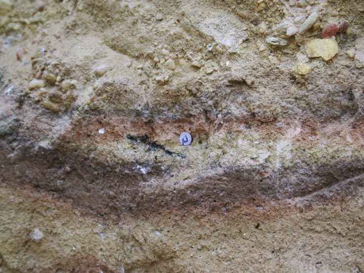
macroscopic
charcoal
Fig. 4. Photograph showing in situ macroscopic charcoal. Diameter of nail head shown is ~8 mm.
charcoal and absence of microscopic charcoal consistency, sample SNI1-17 was analyzed
is unclear but may be due to variable effects of twice (in May and September 2010) and
oxidation processes on different sizes of char- yielded ages that are statistically indistinguish-
coal (large versus small; Cohen-Ofri et al. able (24.88 +
– 0.42 ka and 25.07 + – 0.59 ka).
2006, Ascough et al. 2010), differences in the Thus, we are confident that the ages pre-
preservation potential of the various types of sented here are robust and show little effects
burned vegetation (grass, bushes, trees; Scott of secondary contamination. The calibrated
2010, Ascough et al. 2011), or other factors ages show that the section at the base of
beyond the scope of the current investigation. Chukar Canyon dates to the latter part of
14C marine isotope stage (MIS) 3 and that sedi-
Analysis
mentation continued into early MIS 2.
Our calibrated 14Cages (n = 13) range
Clay Mineralogy
from 24.88 + – 0.42 ka to 36.8 + – 1.5 ka for
samples collected at depths of 0.5 and 4.5 m, Smectite and kaolinite are known to be
respectively, and largely maintain correct sensitive to high temperatures (Carroll 1970)
stratigraphic order (Table 1; Fig. 2). The ages and, therefore, can be used to evaluate whether
are consistently older with depth even when sediments have been subjected to fire events
samples are closely spaced vertically, which during burial. Lower concentrations of these
occurrence is remarkable considering the dis- clays in suspected burn zones than in the adja-
proportionately large effect that small amounts cent host sediment would support the hypothe-
of contamination can have on the measured sis that the burn zones were indeed a prod-
14C activities in older samples (Bird et al. uct of fire. In contrast, if smectite and kao-
1999, Pigati et al. 2007). As a check of internal linite concentrations within suspected burn42 MONOGRAPHS OF THE WESTERN NORTH AMERICAN NATURALIST [Volume 7
aCalibrated ages were calculated using CALIB v. 7.0., IntCal13.14C data set; limit 50.0 calendar ka BP. Calibrated ages are reported as the midpoint of the calibrated range. Uncertainties are calculated as the difference between the midpoint and
zones are identical to those in the host sedi-
1.00
1.00
1.00
1.00
1.00
1.00
1.00
1.00
1.00
1.00
1.00
1.00
1.00
Pb
ment, then other processes would have to be
considered.
At Chukar Canyon, smectite and kaolinite
abundances decrease across the profiles of
Age (cal ka BP)a
BZ8 and BZ5 such that the lowest concentra-
– 0.42
– 0.59
– 0.38
– 0.22
– 0.40
– 0.59
– 0.37
– 0.77
– 0.97
– 0.94
– 0.73
– 0.87
tions are found in samples taken from within
– 1.5
24.88 +
25.07 +
29.10 +
31.15 +
31.19 +
30.36 +
31.01 +
31.94 +
32.80 +
32.98 +
31.85 +
34.78 +
the burn zones and the highest concentrations
36.8 +
are in samples collected in the adjacent host
sediment (Fig. 5). The kaolinite abundances
show the greatest decrease (~9%) in the yel-
lowish red sediments at BZ8 (sample BZ8-3)
age (14C ka BP)
compared to the host sediments. The net de-
– 0.14
– 0.23
– 0.16
– 0.16
– 0.30
– 0.26
– 0.29
– 0.33
– 0.37
– 0.37
– 0.32
– 0.47
– 0.58
crease of smectite and kaolinite is also readily
20.67 +
20.85 +
25.05 +
27.19 +
27.24 +
26.21 +
26.95 +
27.93 +
28.86 +
29.03 +
27.84 +
30.79 +
32.55 +
apparent in the concomitant relative increase
in mica/illite abundances.
The step-heating results of samples BZ8-3
14C
and BZ8-4 also show patterns that implicate
fire as the source of discoloration of the burn
(‰ vpdb)
zones (Fig. 6a, b). After glycolation and heat-
d 13C
–26.0
–23.0
–23.0
–22.6
–22.9
–23.3
–22.7
–21.6
–22.3
–25.6
–24.6
–22.0
ing, the X-ray diffractogram for sample BZ8-3
–25c
shows a clear decrease in the 5.2° 2q smectite
peak after heating to only 150 °C (Fig. 6c),
whereas sample BZ8-4 shows a decrease in
the smectite peak after heating to 250 °C (Fig.
Burn
zone
2
2
4
5
11
12
13
14
15
18
21
21
7
6d). The diffractogram patterns of both samples
show that the 12.4° 2q kaolinite peak re-
either the upper or lower limit of the calibrated age range, whichever is greater (reported at the 95% confidence level; 2σ).
mained stable until the sediments were heated
to 450 °C (Fig. 6e, f ). Above this temperature,
Material
charcoal
charcoal
charcoal
charcoal
charcoal
charcoal
charcoal
charcoal
charcoal
charcoal
charcoal
charcoal
charcoal
the kaolinite peaks in both samples collapsed
dated
entirely.
TABLE 1. Summary of sample information, 14C ages, and calibrated ages.
DISCUSSION
bP = probability of the calibrated age falling within the reported range as calculated by CALIB.
Clay Mineralogy of the Burn Zones
CAMS-147418
CAMS-149133
CAMS-148513
CAMS-149870
CAMS-147416
CAMS-147411
CAMS-147420
CAMS-147412
CAMS-147417
CAMS-147413
CAMS-147422
CAMS-147421
CAMS-147419
Most researchers initially accepted Orr’s
AMS #
hypothesis that the discrete packages of dis-
colored sediments he called fire areas were
related to burn events (e.g., Johnson et al.
1980, Wendorf 1982). This hypothsis was
eventually challenged by a group invoking a
groundwater process to explain the features
(Cushing et al. 1986, Cushing 1993). Although
WW-7858
WW-8061
WW-8015
WW-8161
WW-7853
WW-7856
WW-7860
WW-7854
WW-7857
WW-7855
WW-7862
WW-7861
WW-7859
the groundwater hypothesis does not appear
Lab #
to have gained much support by researchers
working on the islands, it wasn’t until recently
that Rick et al. (2012) used multiple lines of
evidence, including clay mineralogy, to demon-
c d13C value not measured.
strate that the fire areas were indeed the
SNI1-17 (rerun)
result of fire and not groundwater processes.
The results of our study further support
Sample #
this conclusion for several reasons. First, the
SNI1-17
SNI1-20
SNI1-10
SNI1-23
SNI1-21
SNI1-19
SNI-14
SNI-81
SNI1-2
SNI1-9
SNI1-5
SNI1-8
presence of abundant in situ charcoal is a clear
indicator of fire. Most of the discrete pieces of2014] WILDFIRES ON SAN NICOLAS ISLAND 43
a c smectite kaolinite mica/illite
8-1 BZ8-1
8-2 BZ8-2
8-3
BZ8-3
8-4
BZ8-4
8-5 BZ8-5
0% 10% 20% 30% 40% 50% 60% 70% 80%
b
5-6 d smectite kaolinite mica/illite
BZ5-6
5-7
BZ5-7
5-8 BZ5-8
BZ5-9
5-9
0% 10% 20% 30% 40% 50% 60% 70% 80%
Fig. 5. Photographs and sample locations for 2 burn zones: a, BZ8; b, BZ5 (see Fig. 2 for stratigraphic positions). Rela-
tive percentages of smectite, kaolinite, and mica/illite for samples collected at 2 burn zones: c, BZ8; d, BZ5.
charcoal observed in the Chukar Canyon sedi- smectite is known to be physically smaller
ments were associated with features that we than kaolinite, with a typical diameter of 0.01
would interpret as burn zones (based on the mm (10 times smaller than kaolinite), and is
discoloration of the sediment) even if charcoal therefore potentially more physically mobile
was not present. Second, we did not observe in the natural environment (Grim 1962, Gibbs
any difference in grain size, sorting, or other 1965). It is possible to envision a scenario in
features that would suggest that groundwater which sediments were heated originally to
preferentially moved through the burn zones. 350–450 °C during a burn event and buried
If these sediments exhibited a higher porosity shortly thereafter, and then some amount of
and permeability than adjacent sediments, for younger (nonheated) smectite was transported
example, then it might be conceivable that from above by pedogenic eluviation/illuviation
groundwater flowed through and preferen- processes, essentially acting as a contaminant.
tially altered some sediments more than others. Regardless, the burn zones at Chukar Canyon
This was not the case, however, as grain size are similar in appearance to fire areas on Santa
and porosity did not change across the fea- Rosa Island. The burn zone and the physical
tures. Finally, the results of our step-heating and mineralogical evidence presented here
experiments show that the sediments have support the conclusion that these areas were
been heated previously to at least 150–250 °C indeed the result of heating or burning rather
(based on smectite peaks) and, more likely, to than groundwater processes.
as high as 350–450 °C (based on kaolinite
Frequency of Natural Wildfires
peaks). We favor the higher estimate because
on San Nicolas Island
the kaolinite peaks were clearer, more stable,
and therefore easier to interpret than the The oldest documented evidence of human
smectite peaks at all temperatures (including occupation on San Nicolas Island is ~8.5 ka
the unheated, air-dried aliquot). Moreover, (Schwartz and Martz 1992), although evidence44 MONOGRAPHS OF THE WESTERN NORTH AMERICAN NATURALIST [Volume 7
1200 1200
a b
BZ8-3 BZ8-4
1000 0 ºC raw 1000 0 ºC raw
0 ºC 0 ºC
Intensity (Counts)
150 ºC 150 ºC
800 800
250 ºC 250 ºC
350 ºC 350 ºC
450 ºC 450 ºC
600 600
550 ºC 550 ºC
c d
400 400
e f
200 200
0 0
3 5 7 9 11 13 15 3 5 7 9 11 13 15
500 500
c d
450 450
400 400
Intensity (Counts)
350 350
300 300
250 250
200 200
150 150
4.2 4.4 4.6 4.8 5.0 5.2 5.4 5.6 5.8 6.0 6.2 4.2 4.4 4.6 4.8 5.0 5.2 5.4 5.6 5.8 6.0 6.2
350 350
e f
300 300
Intensity (Counts)
250 250
200 200
150 150
100 100
50 50
11.4 11.6 11.8 12.0 12.2 12.4 12.6 12.8 13.0 13.2 13.4 11.4 11.6 11.8 12.0 12.2 12.4 12.6 12.8 13.0 13.2 13.4
2 (º) 2 (º)
Fig. 6. X-ray diffractograms for samples BZ8-3 (a, c, e) and BZ8-4 (b, d, f ), including the full spectrum from 3° to 15°
(a, b), the smectite peak centered at 5.2° (c, d), and the kaolinite peak centered at 12.4° (e, f ). See Fig. 5 for specific sam-
ple locations. Legends shown in the top panels are the same for all panels. The thin black line denotes raw data taken at
0.02° increments. All other lines represent running 5-point mean averages, which correspond to a 2q uncertainty of
0.04°. Note the clear decrease in the kaolinite peaks (e, f ) for both samples when heated to 450 °C, which suggests that
the sediments had been heated previously to 350–450 °C.
from Santa Rosa Island suggests that hu- is inconsequential as the calibrated 14C ages
mans were present on the northern Channel of the burn zones at Chukar Canyon date to
Islands by ~13 ka (Orr 1968, Johnson et al. between ~37 and 25 ka, well before the
2002, Stafford et al. 2008). Whether or not arrival of humans in North America in general
humans first arrived on San Nicolas Island in (Meltzer 2009) and coastal southern California
the early Holocene or several millennia earlier and the Channel Islands in particular. Thus,2014] WILDFIRES ON SAN NICOLAS ISLAND 45
we can safely assume the fires that created Direct comparison of the Chukar Canyon
the burn zones at Chukar Canyon are not record with other nearby charcoal-based rec-
anthropogenic. ords is not possible because continuous char-
The mean fire interval (MFI) is a useful coal sequences from other localities in coastal
metric for quantifying fire regimes and repre- southern California either do not predate the
sents the average amount of time between arrival of humans (Cole and Liu 1994, Ander-
fires at a given location over a specific time son et al. 2009) or represent an undefined spa-
period (McBride 1983). Here, calculated MFI tial extent (Heusser and Sirocko 1997). Thus,
values represent the average duration be- our results provide the first baseline of MFI
tween fire occurrences in the Chukar Canyon values against which future studies of fire
drainage basin over the period defined by recurrence intervals on the Channel Islands
the calibrated 14C ages. As a whole, the allu- can be compared directly.
vial sequence at Chukar Canyon suggests that
as many as 24 different fire events occurred Conclusions
here in a span of ~12 ka, corresponding to The sedimentary sequence discovered at
an overall MFI of ~500 years. However, burn Chukar Canyon on the north side of San Nico-
zones BZ4 through BZ21 apparently occurred las Island provides an opportunity to quantify
in a relatively short amount of time, only ~6 the frequency of fire on the California Chan-
ka, meaning that the MFI was only ~300 nel Islands prior to the arrival of humans. Our
years between approximately 29 and 35 ka. 14C-based chronology and the sedimentology
Whether examining the record in its entirety of the deposits exposed at Chukar Canyon
or looking only at the peak frequency period, show that fires that were large enough in both
the MFI values presented here should be magnitude and intensity to be preserved in
viewed as maxima because it is likely that the geologic record occurred at least every
smaller, less intense burn events that were not 300–500 years in this catchment area between
captured in the geologic record occurred at ~37 and 25 ka, and likely more often than
our study site during this period. Moreover, that. These recurrence intervals are similar to
considering the relatively low elevation of both modern observations and modeled pre-
the Chukar Canyon catchment area, which anthropogenic values on the mainland, al-
does not exceed ~275 m asl, the calculated though the validity of such comparisons is lim-
MFIs are likely on the high end for the Chan- ited because of differences in vegetation types,
nel Islands as a whole if we extrapolate the climate regimes, sedimentary processes, and
relation between elevation and the number the methodologies used in the various studies.
of lightning-induced fires observed today Nevertheless, our study provides a baseline
(Keeley 2002). against which to compare future assessments
The MFI values calculated for the Chukar of fire regimes in this region, as well as studies
Canyon catchment area are similar to modern aimed at determining if and when fire was
MFI values (200–500 years) observed in the used by early humans to alter late Pleistocene
San Diego County–northern Baja California landscapes on the Channel Islands.
area for an area of similar size (~1 km) and
when accounting for only lightning-induced ACKNOWLEDGMENTS
fires (Minnich et al. 1993, Wells and McKin-
sey 1995). The Chukar Canyon results are also We thank Lisa Thomas-Barnett and Steven
broadly similar to modeled MFI values for Schwartz for logistical and scientific support
preanthropogenic MFIs in the redwood forests on San Nicolas Island. We also thank Eugene
of Santa Cruz County, located farther north in Schweig and DeAnna Laurel for field assis-
central California (MFI = 135 years; Greenlee tance and Paco van Sistine for technical as-
and Langenheim 1990). However, the validity sistance. This manuscript benefitted from con-
of such comparisons is limited by differences structive reviews from Diane Stephens, Jenny
in vegetation and climate regimes, spatial ex- Briggs, Janet Slate, Annie Little, and an anony-
tent of the areas studied, size of the fires mous reviewer. This project was funded by the
(small fires may not be accounted for in the U.S. Geological Survey’s Climate and Land Use
Chukar Canyon sediments), and the method- Change Research and Development Program.
ologies employed (Marlon et al. 2009, 2012). Any use of trade, product, or firm names is for46 MONOGRAPHS OF THE WESTERN NORTH AMERICAN NATURALIST [Volume 7
descriptive purposes only and does not imply Barbara Museum of Natural History, Santa Barbara,
endorsement by the U.S. Government. CA.
CUSHING, J.E., A.M. WENNER, E. NOBLE, AND M. DAILY.
1986. A groundwater hypothesis for the origins of
LITERATURE CITED the “fire areas” on the northern Channel Islands,
California. Quaternary Research 26:207–217.
ANDERSON, R.S., S. STARRATT, R.M. JASS, AND N. PINTER. DANIAU, A.L., P.J. BARTLEIN, S.P. HARRISON, I.C. PREN-
2009. Fire and vegetation history on Santa Rosa TICE, S. BREWER, P. FRIEDLINGSTEIN, T.I. HARRISON-
Island, Channel Islands, and long-term environmen- PRENTICE, J. INOUE, K. IZUMI, J.R. MARLON, ET AL.
tal change in southern California. Journal of Quater- 2012. Predictability of biomass burning in response
nary Science 25:782–797. to climate change. Global Biogeochemical Cycles 26:
ARCHIBALD, S., A.C. STRAVER, AND A. LEVIN. 2012. Evolu- GB4007, http:/dx.doi.org/4010.1029/2011GB004249
tion of human-driven fire regimes in Africa. Pro- ERLANDSON, J.M., T.C. RICK, T.J. BRAJE, M. CASPERSON, B.
ceedings of the National Academy of Sciences USA CULLETON, B. FULFROST, T. GARCIA, D.A. GUTHRIE,
109:847–852. N. JEW, D.J. KENNETT, ET AL. 2012. Paleoindian sea-
ASCOUGH, P.L., M.I. BIRD, S.M. FRANCIS, B. THORNTON, faring, maritime technologies, and coastal foraging on
A.J. MIDWOOD, A.C. SCOTT, AND D. APPERLEY. 2011. California’s Channel Islands. Science 331:1181–1185.
Variability in oxidative degradation of charcoal: in- GIBBS, R.L. 1965. Error due to segregation in quantitative
fluence of production conditions and environmental clay mineral X-ray diffraction techniques. American
exposure. Geochimica et Cosmochimica Acta 75: Mineralogist 50:741–751.
2361–2378. GREENLEE, J.M., AND J.H. LANGENHEIM. 1990. Historic
ASCOUGH, P.L., M.I. BIRD, A.C. SCOTT, M.E. COLLINSON, fire regimes and their relation to vegetation patterns
I. COHEN-OFRI, C.E. SNAPE, AND K. LE MANQUAIS. in the Monterey Bay area of California. American
2010. Charcoal reflectance measurements: implica- Midland Naturalist 124:239–253.
tions for structural characterization and assessment GRIM, R.E. 1962. Applied clay mineralogy. McGraw-Hill
of diagenetic alteration. Journal of Archaeological Publishing Company, New York, NY.
Science 37:1590–1599. HALLBERG, G.R., J.R. LUCAS, AND C.M. GOODMEN. 1978.
BERNA, F., P. GOLDBERG, L. KOLSKA-HORWITZ, J. BRINK, S. Semi-quantitative analysis of clay mineralogy. Pages
HOLT, M. BAMFORD, AND M. CHAZAN. 2012. Micro 5–22 in G.R. Hallberg, editor, Standard procedures
stratigraphic evidence of in situ fire in the Acheu- for evaluation of Quaternary materials in Iowa. Iowa
lean strata of Wonderwerk Cave, Northern Cape Geological Survey, Iowa City, IA.
Province, South Africa. Proceedings of the National HEUSSER, L.E. 1995. Pollen stratigraphy and paleoeco-
Academy of Sciences USA 109:E1215–E1220. logic interpretation of the 160-k.y. record from Santa
BIRD, M.I., L.K. AYLIFFE, L.K. FIFIELD, C.S.M. TURNEY, Barbara Basin, Hole 893A1. Proceedings of the
R.G. CRESSWELL, T.T. BARROWS, AND B. DAVID. 1999. Ocean Drilling Program, Scientific Results 146
Radiocarbon dating of “old” charcoal using a wet (pt. 2):265–279.
oxidation, stepped-combustion technique. Radiocar- HEUSSER, L.E., AND F. SIROCKO. 1997. Millennial pulsing
bon 41:127–140. of environmental change in southern California from
BOWMAN, D.M.J.S., J.K. BALCH, P. ARTAXO, W.J. BOND, J.M. the past 24 k.y.: a record of Indo-Pacific ENSO
CARLSON, M.A. COCHRANE, C.N. D’ANTONIO, R.S. events? Geology 25:243–246.
DEFRIES, J.C. DOYLE, S.P. HARRISON, ET AL. 2009. JOHNSON, D.L. 1977. The Late Quaternary climate of
Fire in the Earth system. Science 324:481–484. coastal California: evidence for an ice age refugium.
BOWMAN, D.M.J.S., J.K. BALCH, P. ARTAXO, W.J. BOND, Quaternary Research 8:154–179.
M.A. COCHRANE, C.N. D’ANTONIO, R.S. DEFRIES, JOHNSON, D.L., D.D. COLEMAN, M.A. GLASSOW, R.S.
F.H. JOHNSTON, J.E. KEELEY, M.A. KRAWCHUK, ET GREENWOOD, AND P.L. WALKER. 1980. Late Quater-
AL. 2011. The human dimension of fire regimes on nary environments and events on the California
Earth. Journal of Biogeography 38:2223–2236. Channel Islands and adjacent mainland. Bulletin of
BROWN, K.S., C.W. MAREAN, A.I.R. HERRIES, Z. JACOBS, the Ecological Society of America 61:106–107.
C. TRIBOLO, D. BRAUN, D.L. ROBERTS, M.C. MEYER, JOHNSON, J.R., T. STAFFORD, H. AJIE, AND D.P. MORRIS.
AND J. BERNATCHEZ . 2009. Fire as an engineering 2002. Arlington Springs revisited. Page 541–545 in
tool of early modern humans. Science 325:859–862. D. Browne, K. Mitchell, H. Chaney, editors, 5th Cali-
CARROLL, D. 1970. Clay minerals: a guide to their X-ray fornia Islands Conference. Santa Barbara Museum
identification. Geological Society of America Special of Natural History, Santa Barbara, CA.
Paper 126:1–80. JUNAK, S., T. AYERS, R. SCOTT, D. WILKEN, AND D. YOUNG.
COHEN-OFRI, I., L. WEINER, E. BOARETTO, G. MINTZ, 1995. The flora of Santa Cruz Island. California
AND S. WEINER. 2006. Modern and fossil charcoal: Native Plant Society, Santa Barbara Botanic Gar-
aspects of structure and diagenesis. Journal of Ar- dens, Santa Barbara, CA.
chaeological Science 33:428–439. KEELEY, J.E. 2002. Native American impacts on fire
COLE, K.L., AND G.W. LIU. 1994. Holocene paleoecology regimes of the California coastal ranges. Journal of
of an estuary on Santa Rosa Island, California. Qua- Biogeography 29:303–320.
ternary Research 41:326–335. KENNETT, D.J., J.P. KENNETT, G.J. WEST, J.M. ERLANDSON,
CUSHING, J.E. 1993. The carbonization of vegetation asso- J.R. JOHNSON, I.L. HENDY, A. WEST, B.J. CULLETON,
ciated with “fire areas”: mammoth remains and T.L. JONES, AND T.W. STAFFORD. 2008. Wildfire and
hypothesized activities of early man on the northern abrupt ecosystem disruption on California’s North-
Channel Islands. Pages 551–556 in F.G. Hochberg, ern Channel Islands at the Allerød–Younger Dryas
editor, Third California Islands Symposium: recent boundary (13.0–12.9 ka). Quaternary Science Reviews
advances in research on the California Islands. Santa 27:2530–2545.2014] WILDFIRES ON SAN NICOLAS ISLAND 47
MARLON, J.R., P.J. BARTLEIN, D.G. GAVIN, C.J. LONG, R.S. The Younger Dryas impact hypothesis: a requiem.
ANDERSON, C.E. BRILES, K.J. BROWN, D. COLOM- Earth Science Reviews 106:247–264.
BAROLI , D.J. H ALLETT, M.J. P OWER , ET AL . 2012. REIMER, P.J., E. BARD, A. BAYLISS, J.W. BECK, P.G. BLACK-
Long-term perspective on wildfires in western USA. WELL, C. BRONK RAMSEY, P.M. GROOTES, T.P. GUILDER-
Proceedings of the National Academy of Sciences SON, H. HAFLIDASON, I. HAJDAS, ET AL. 2013. Int-
USA 109:E535–E543. Cal13 and Marine13 Radiocarbon Age Calibration
MARLON, J.R., P.J. BARTLEIN, M.K. WALSH, S.P. HARRISON, Curves 0–50,000 Years cal BP. Radiocarbon 55:
K.J. BROWN, M.E. EDWARDS, P.E. HIGUERA, M.J. 1869–1887.
POWER, R.S. ANDERSON, C. BRILES, ET AL. 2009. Wild- RICK, T.C., J.S. WAH, AND J.M. ERLANDSON. 2012. Re-
fire responses to abrupt climate change in North evaluating the origins of Late Pleistocene fire areas
America. Proceedings of the National Academy of on Santa Rosa Island, California, USA. Quaternary
Sciences 106:2519–2524. Research 78:353–362.
MCBRIDE, J.R. 1983. Analysis of tree rings and fire scars ROEBROEKS, W., AND P. VILLA. 2011. On the earliest evi-
to establish fire history. Tree-Ring Bulletin 43:51–67. dence of habitual use of fire in Europe. Proceedings
MELTZER, D.J. 2009. First peoples in a new world: colo- of the National Academy of Sciences USA 108:
nizing Ice Age America. University of California 5209–5214.
Press, Berkeley, CA. SCHWARTZ, S., AND P. MARTZ. 1992. An overview of the
MINNICH, R.A., E.F. VISCAINO, J. SOSA-RAMIREZ, AND Y. archaeology of San Nicolas Island, southern Califor-
CHOU. 1993. Lightning detection rates and wildland nia. Pacific Coast Archaeological Society Quarterly
fire in the mountains of northern Baja California, 28:46–75.
Mexico. Atmosfera 6:235–253. SCOTT, A.C. 2010. Charcoal recognition, taphonomy, and
MOONEY, S.D., S.P. HARRISON, P.J. BARTLEIN, A.L. DANIAU, uses in palaeoenvironmental analysis. Palaeogeogra-
J. STEVENSON, K.C. BROWNLIE, S. BUCKMAN, M. phy, Palaeoclimatology, Palaeoecology 291:11–39.
CUPPER, J. LULY, M. BLACK, ET AL. 2011. Late Qua- SCOTT, A.C., N. HARDIMAN, N. PINTER, AND R.S. ANDER-
ternary fire regimes of Australasia. Quaternary Sci- SON. 2011. Evidence of fire regimes in the Pleis-
ence Reviews 30:28–46. tocene of the California Islands. Pages 59–60 in E.
MOORE, D.M., AND R.C. REYNOLDS. 1989. X-ray diffraction Badal and Y. Carrión, editors, 5th International
and the identification and analysis of clay minerals. Meeting of Charcoal Analysis, Valencia, Spain.
Oxford University Press, Oxford. STAFFORD, T.W., J.R. JOHNSON, AND G.J. WEST. 2008. New
MUHS, D.R. 1985. Amino acid age estimates of marine ter- chronological and geological data from the Arlington
races and sea levels on San Nicolas Island, California. Springs site. Page 73 in Seventh California Islands
Geology 13:58–61. Symposium, Channel Islands National Park, California.
MUHS, D.R., K.R. SIMMONS, R.R. SCHUMANN, L.T. GROVES, STUIVER, M., AND P.J. REIMER. 1993. Extended 14C data-
J.X. MITROVICA, AND D. LAUREL. 2012. Sea-level his- base and revised CALIB radiocarbon calibration pro-
tory during the Last Interglacial complex on San gram. Radiocarbon 35:215–230.
Nicolas Island, California: implications for glacial VEDDER, J.G., AND R.M. NORRIS. 1963. Geology of San
isostatic adjustment processes, paleozoogeography Nicolas Island, California. U.S. Geological Survey
and tectonics. Quaternary Science Reviews 37:1–25. Professional Paper 369. 65 pp.
ORR, P.C. 1968. Prehistory of Santa Rosa Island. Santa Bar- WELLS, M.L., AND D.E. MCKINSEY. 1995. Lightning strikes
bara Museum of Natural History, Santa Barbara, CA. and natural fire regimes in San Diego County, Cali-
ORR, P.C., AND R. BERGER. 1966. The fire areas on Santa fornia. Pages 193–194 in D.R. Weise and R.E. Mar-
Rosa Island, California. Proceedings of the National tin, editors, The Biswell Symposium: fire issues and
Academy of Sciences USA 56:1409–1416. solutions in an urban interface and wildland ecosys-
PIGATI, J.S., J. QUADE, J. WILSON, A.J.T. JULL, AND N.A. tems. General Technical Report PSW-GTR-158, Pacific
LIFTON. 2007. Development of low-background Southwest Research Station, USDA Forest Service,
vacuum extraction and graphitization systems for Berkeley, CA.
14C dating of old (40–60 ka) samples. Quaternary WENDORF, M. 1982. The fire areas of Santa Rosa Island:
International 166:4–14. an interpretation. North American Archaeologist 3:
PINTER, N., S. FIEDEL, AND J.E. KEELEY. 2011a. Fire and 173–180.
vegetation shifts in the Americas at the vanguard of
Paleoindian migration. Quaternary Science Reviews Received 27 February 2013
30:269–272. Accepted 17 April 2014
PINTER, N., A.C. SCOTT, T.L. DAULTON, A. PODOLL, C. Early online 26 August 2014
KOEBERL, R.S. ANDERSON, AND S.E. ISHMAN. 2011b.You can also read