Erdbeobachtung in der Arktis Herzlich Willkommen
←
→
Page content transcription
If your browser does not render page correctly, please read the page content below
Erdbeobachtung in der Arktis

                                                                                      Herzlich Willkommen

                                  Erdbeobachtung in der Arktis, Potsdam, 22.11.2017
© CNES 2005, Distribution Airbus DS
1
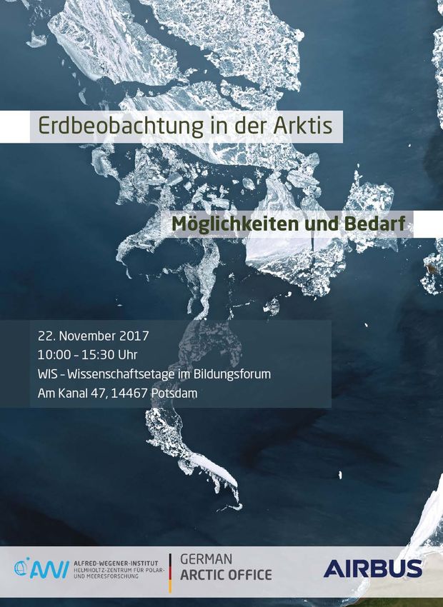
Erdbeobachtung in der Arktis
Operationelle Möglichkeiten der
Radarfernerkundung
Dr. Oliver Lang

Potsdam, 22. November 2017
Erdbeobachtung in der Arktis, Potsdam, 22.11.2017
Airbus Defence and Space - Intelligence
Constellation of Optic and SAR Satellites
    Pléiades                   SPOT                             TerraSAR-X              DMC                       FORMOSAT-2
                                                                TanDEM-X                Constellation
    • Very high resolution     • High resolution twin           • Radar satellite       • Vast daily collection
                                                                                                                  • Reactive 2m-res
      twin satellites [50cm]     satellites [1.5m]                formation               capacity
                                                                                                                    satellite
    • Daily revisit capacity • 60km swath for                   • Various resolutions   • 600km swath for
                                                                                          rapid coverage and      • Daily revisit capacity
      and highly reactive      large-area coverage                [0.25m to 40m] and
      tasking                                                     scene sizes             revisit
                             • Daily revisit capacity

                          Erdbeobachtung in der Arktis, Potsdam, 22.11.2017
4
Gulf of Bothnia
                                                    TerraSAR-X Wide ScanSAR, 17.03.2013
                                                    HH-Polarization
© DLR e.V. 2013 and © Airbus DS Geo GmbH 2013

                                                5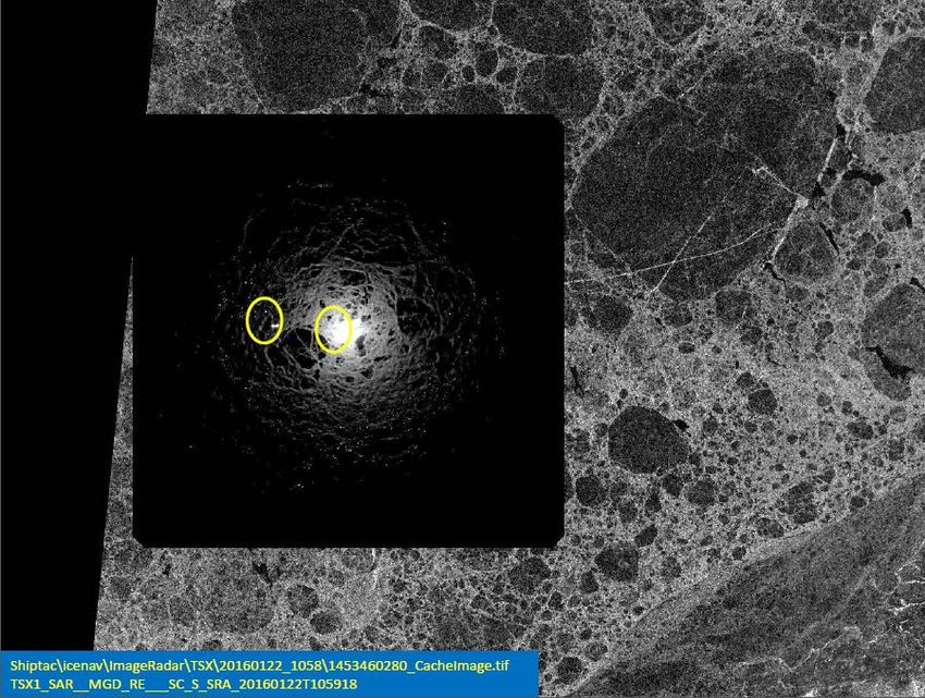
Spaceborne Radar imagery: an ideal source for maritime surveillance

             Erdbeobachtung in der Arktis, Potsdam, 22.11.2017
6
Erdbeobachtung in Polarregionen mit SAR-Sensoren: Möglichkeiten heute

                                                                 Trend zu zunehmendem Schiffsverkehr und
                                                                 Gewinnung von Bodenschätzen in der Arktis

                                                                 Fernerkundung trägt zur taktischen und
                                                                 strategischen Lageerfassung bei

    © USGS

                                                                 •   Routenoptimierung
                                                                 •   Search and Rescue
                                                                 •   Ice Charting
                                                                 •   Detektion von Eisgefahren (z.B. Eisberge,
                                                                     Presseisrücken)

             Erdbeobachtung in der Arktis, Potsdam, 22.11.2017
7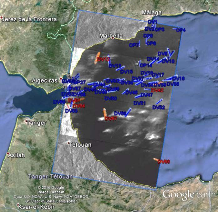
Daten auf die Brücke: Demonstration mit Endnutzer (Reederei)

                                                                                                                 Nunavik

                                                               7 RadarSAT2 Images: Jan20 to Jan 26th   Arctic   AIS Tracks
                                                               Dual pol( HV/HH) SCWA

                                                               6 TerraSAR-X: Jan. 20 – 23
           Erdbeobachtung in der Arktis, Potsdam, 22.11.2017   ScanSAR, HH-Pol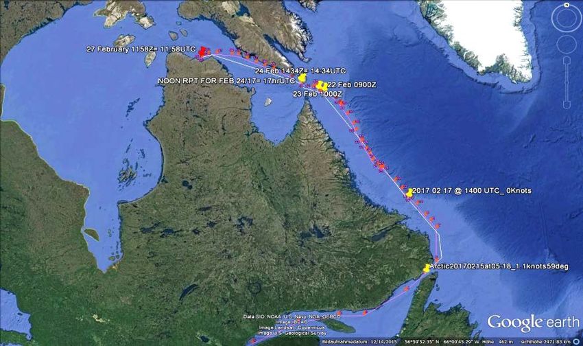
Daten auf die Brücke:
                                                    Demonstration mit
                                                    Endnutzer (Reederei)

                                                    TerraSAR-X ScanSAR
                                                    +
                                                    FedNav on board ice radar

Erdbeobachtung in der Arktis, Potsdam, 22.11.2017
Datenveredlung: operationelle Schiffsdetektion
Incl. automatic
vessel detection /
AIS correlation
Erdbeobachtung in der Arktis, Potsdam, 22.11.2017
10Datenveredlung: Operationelle Objektdetektion
Schiffe: vergleich mit AIS Eisberge
AIS data provided by 2014-08-03, 21:17:00 UTC, TerraSAR-X ScanSAR: 36,14° – 43,92°
Detection kindly provided by DLR
SAR/AIS merge provided by
11TerraSAR-X
Scientific Study:
TanDEM-X
Sea-Ice Topography from bistatic data
• Goal: Detection of sea-ice hazards
• Method: Interferometric measurement
of sea-ice topography using bistatic
data of the TanDEM mission
• Geometry: eff. Baseline > 500m,
incidence angle < 45°
• Data access not operational today
Ice Ridging Sample
Image by P. Clemente-Colon / I. Rigor
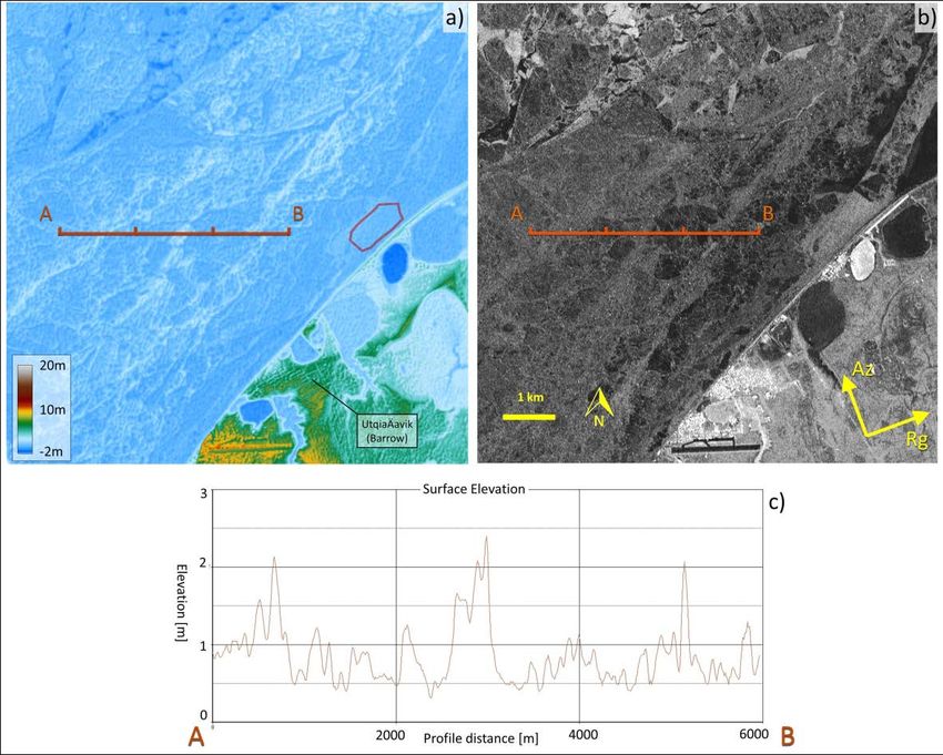
12Scientific Study:
Sea-Ice Topography from
bistatic data
• Example: Pt. Barrow, Alaska
• Publication:
Dierking, W., Lang, O., and Busche, T.: Sea ice
local surface topography from single-pass satellite
InSAR measurements: a feasibility study, The
Cryosphere Discuss., doi:10.5194/tc-2017-40, in
review, 2017. (http://www.the-cryosphere-
Acquisition: March 29, 2015
discuss.net/tc-2017-40/) Effective Baseline = 1113 m
Height of Ambiguity = 7.4 m
Inc. Angle = 27.3°
Pixel size: 12 m
STD (z) = 0.12 m
13Ausblick: WorldSAR Konzept – laufende und kommende Missionen
HRWS (2022)
PAZ (2018)
TerraSAR-X (2007) Export Type A
Export Type B
TanDEM-X (2010)
WorldSAR Next Generation
§ PAZ
WorldSAR
§ HRWS
Constellation cooperation
§ Export Mission(s)
with Hisdesat (ES)Ausblick: Lageerfassung durch Sensorverbund
Idee: Integriertes
Sensorkonzept
• Satellit
• HAPS (Pseudo
Satelliten)
• UAV, Flugzeug
• Terrestrische
Sensorik
• Schiffsradar
15Vielen Dank
Dr. Oliver Lang
Head of SAR-Monitoring Services, Intelligence
Airbus Defence and Space
Platz der Einheit 14, 14467 Potsdam, Germany
T +49 331 237 484 24
M +49 151 1822 0827
E oliver.ol.lang@airbus.com
www.intelligence-airbusds.com Wilkizki Strait, Colorized TSX ScanSAR,
August 2012 – April 2013
16You can also read