Environment Committee Meeting - Separate Attachment 15 March 2018 - This attachments relate to Item 5
←
→
Page content transcription
If your browser does not render page correctly, please read the page content below
Environment Committee
       Meeting
          15 March 2018

    Separate Attachment
       (as indicated this is attached separately)

This attachments relate to Item 5
          in the Agenda
MEMORANDUM FROM DEBS MARTIN
           ON BEHALF OF THE ROYAL FOREST AND BIRD PROTECTION SOCIETY OF
                                          NEW ZEALAND INCORPORATED

                                                              TO

                  ENVIRONMENT COMMITTEE, MARLBOROUGH DISTRICT COUNCIL

                                                       15 March 2017

Royal Forest and Bird Protection Society of New Zealand Inc
PO Box 266
Nelson
7040

1. My name is Debs Martin and I have worked as Regional Manager for the Royal Forest & Bird
   Society of NZ Inc. since November 2004.

2. Forest and Bird has been in existence since 1923, 95 years ago, and was formed because of
   the strong concerns of a community of people within our country (including well known and
   respected scientists of the time), about the huge degradation of our natural environment.
   At the time, the large scale felling of forests along and alarming rate of bird species declines,
   were our primary concerns, hence the name.

3. Our organisation now numbers around 70,000 members and supporters across the country.
   Our mission remains the same – to protect the indigenous biological diversity and natural
   features of New Zealand. We are the longest standing, and most widely recognised and
   respected conservation organisation in the country.

4. Forest & Bird has a long association in Marlborough – our Marlborough Branch formed in
   1969 and currently numbers around 250 members with an additional 500 engaged
   supporters. Our members participate in a number of restoration projects in the region.
   They have played leading roles in the establishment of Kaipupu Point Sanctuary, and more
   recently the Picton and Rarangi Dawn Chorus predator control projects. Our members are
   also involved in bird identification, monitoring and banding – especially on the Wairau River
   and alongside members of the Ornithological Society of NZ (Birds NZ).

5. The role of Regional Manager within the organisation is to work with regionally, nationally
   and internationally significant conservation issues within the region to progress the key
   objective of Forest and Bird’s constitution:
   To take all reasonable steps within the power of the Society for the preservation and
    protection of the indigenous flora and fauna and natural features of New Zealand.

6. My presentation to you today is to request that you invoke Traffic Bylaw 2017 section 9(1)
   with respect to prohibiting the use of motor vehicles on any unformed legal road or beach
   along the East Coast of Marlborough between Marfells Beach and the Waima/Ure River
   mouth to give effect to the New Zealand Coastal Policy Statement and a number of the
   Objectives, Policies and Map Overlays in the proposed Marlborough Environment Plan.

7. I am aware of the effects of the 14th November 2016 earthquake on the coastal margin,
   including substantial uplift that has raised the beach and related geological formations
   several metres above their former level. Forest & Bird has had representation on the East
   Coast Protection Group and has participated in discussions to help try to alleviate some of
   the problems caused by vehicle access to the beach over the past year, but is very
   disappointed that no action has been taken to restrict damaging access.

8. I have visited the site on numerous occasions, most recently on the 24th January 2018. On
   that day I travelled alongside the beach on Lighthouse Road from Canterbury Gully to Cape
   Campbell, visited Marfells Beach, and walked from Ward Beach to Chancet Rocks.

9. The coastline is identified in the proposed Marlborough Environment Plan as an area of
   outstanding natural landscape (including marine and to the nearest visible ridgeline –

                                                                                                   1
excluding the quarry north of Chancet Rocks), and has natural character values of
              outstanding, very high and high. The length of the area from the western side of Cape
              Campbell through to just south of the Needles is an ecologically significant marine site. The
              entire marine area (including Clifford Bay) is an ecologically significant marine mammal
              (whale) site; and Clifford Bay for a distance directly eastwards of Cape Campbell is an
              ecologically significant marine mammal (dolphin) site. Almost the entire terrestrial aspect of
              the coastline (excluding a small stretch north of Chancet Rocks) is mapped as a threatened
              environment.

f Environment Plan - Ovei x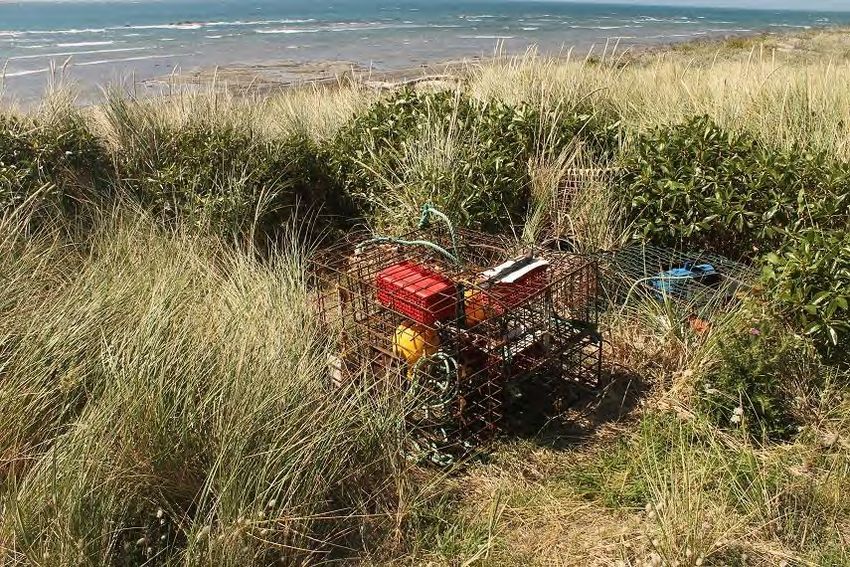
—
                                                                              'kma
                                                                                      »r

                                                      2-
                                                -j*            m
                                             / r -■
                                            j£r*i
m                          mm
                   m■*-          I*
                    - V^'

Figure 2: From Department of Conservation site at Marfells Beach looking toward Mussel Point. [24 Jan 2018]

    13. Figure 3 shows the view from Cape Campbell as it sweeps around Clifford Bay towards
        Mussel Point and on to Marfells Beach.

                                                                             Xv

                                             #■

Figure 3: Cape Campbell towards Marfells Beach [24 Jan 2018]

                                                                                                          3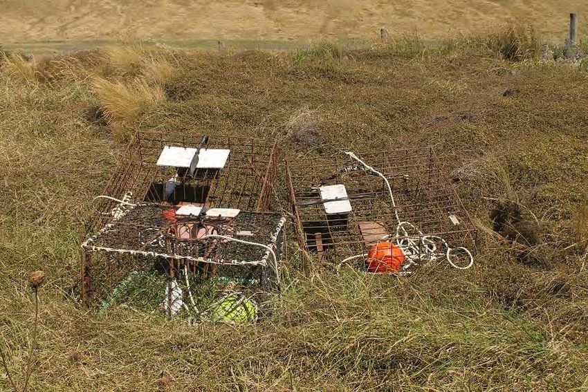
14. Figure 4 below is taken from the southern side of the Lighthouse looking south, showing the
        coastline in both directions and the landscapes forming part of the “Limestone Coastline” as
        described in Boffa Miskell (2015)1. Three sites within the Limestone Coastline are identified
        in the New Zealand Geopreservation Inventory, and referred to by Boffa Miskell: Needles
        Point Cretaceous-Tertiary Boundary, Flaxbourne River folds and thrusts, and the Chancet
        Rocks2.

                                                                                                     ■V
                                                                                                      - w
                                                                                                    . ^      ■ >

                                                                                                         .

Figure 4: View from Cape Campbell looking south west across the limestone based geologies [24 Jan 2018].

    15. Figure 5 below shows the uplifted coastline looking south from the Cape Campbell airstrip
        towards Long Point and then on to Chancet Rocks. The extensive sandstone pavements are
        visible here and at other places along the coast, especially between Ward Beach and
        Chancet Rocks.

1
  Boffa Miskell Ltd and Marlborough District Council (August 2015). Marlborough Landscape Study: Landscape
Characterisatiaon and Evaluation. p152-153.
2
  http://www.geomarine.org.nz/NZGI/

                                                                                                                   4
-V

                                                                 r
                                                              Wl 1                                    u
                                                       iMwa                                           iW
Figure 5: Looking from Cape Campbell airstrip south towards Chancet Rocks [24 Jan 2018]

       16. Figure 6 shows the extensive coastline looking northwest from Chancet Rocks scientific
           reserve towards Long Point and then onto Cape Campbell in the far distance.

                                                       - •   y?r-
m
                                                                                  ' -•
                                                               a.- ' > - i

                                                                              k-- -, '^r .        . . ^ v-^ftl   - > -e- - : -
                                                                              Ki l l I'n >3^... '     . ' vm••
                                                                                                      -\j}            '
 mxt
-1
                                                                                                ..»r, V - ^
                                                                                                    v - •
                                                                                                        ^^v.-:
                                            -:                                                                 v- •-
                                                                                               ■^ . r

Figure 6: Chancet Rocks to Cape Campbell [24 Jan 2018]

                                                                                                                           5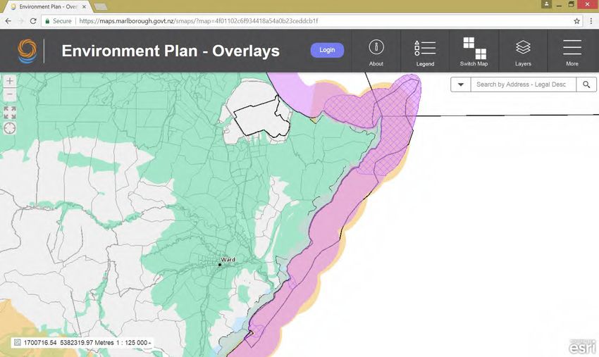
17. Figure 7 shows part of the internationally significant Chancet Rocks scientific reserve and
         geopreservation site. The site is ranked A: internationally important with a vulnerability
         index of 1: vulnerable to complete destruction by human activity3. The photo is taken
         looking south east from the northern most point of the largest tilted rock.

                                                                                         i ^
                                                                 u:                     iA
                                                                                  m

                                                                  y                            %

                                                                                  WJ
                                                                                               I
                                                                                  K
                                                            o                                         '!

                                                                                       5^ *                m
                                                      J               4-.
                                             >■ /<                                s
                                                 v
I j'sfe
->
1
*<
.- ^,-:r r.'
•A' W
;-
3r
'■
f m
Mr
z& :*?£«r
'V
Figure 8: Taken from within Chancet Rocks scientific reserve looking northwest. Notice native iceplant
growing on the rocks in the foreground. [24 Jan 2018]
19. Figure 9 below shows the Chancet Rocks formation as it continues out into the sea.
- • .>•
M: :•«■;
„J|^^ r»
» •:?4!»'
Figure 9: Chancet Bay Beach and out towards rocks [23 Jun 2017]
720. Figure 10 below is standing on the south side of the Chancet Rocks looking down towards
Ward Beach and on to the Needles. The row of rocks out to sea encloses the south end of
Chancet Bay, mirroring a similar row of rocks to the north (just out of view).
- ■ • - a
C* -
1
r?f* >-> .>
.*
k&K t'^4 I *- - • .• * ^ ■"
I , : ' ^
>
■ 1:, I
-• '* t-
1
V
5S .. LOV
■ '■>
^r V ■*i 1 f
►- - . x. .t;
-Jft
Figure 10: Chancet Bay looking south [24 Jan 2018]
21. Figure 11 is taken from the same position using a zoom lens to show the detail through to
the Needles4. Again the Needles is noted in the geopreservation inventory, this time with a
classification of B for importance (i.e. national) and 3 for its vulnerability: probably not
vulnerable to any likely human actions. The rocks in the coastal area foreground are part of
the geopreservation site near Ward Beach (further details below) and have been uplifted
during the earthquake.
4
From the New Zealand Geopreservation Inventory: http://www.geomarine.org.nz/NZGI/ Needles Point pinnacles
and CretaceousTertiary boundary. Map: P29; Classification: B3. Significance: Good KT boundary exposures and spectacular
coastal erosion features.
8Bm3
Ks—^ ^ * »_
■'' .-■* pr - r
''K^Pms^-
tfv n'mii
s
Figure 11: The Needles from Chancet Rocks [23 Jun 2017]
22. Figure 12 below is on the dunelands looking north back towards Chancet Bay with the two
rows of rocks forming the bay clearly visible. The dunelands in this area are part of the
conservation zone, with an unformed legal road running through the dunes.
—
n l \K T■
M *
W- T"'
,VW^ ^ , _v ^ - • JflR^l «- Am
1 A> ft> f •": ^ ^ -%v kfe
'i IB1 l *c
-V.
•*-• ■ V;:
r
Figure 12: Chancet Bay from coastal dunes. [23 Jun 2017]
923. Figure 13 below shows part of the geopreservation site listed in the landscape report
prepared for the Marlborough Environment Plan. The site is identified as the Flaxbourne
River folds and thrusts5. It is ranked as C for importance (i.e. regionally important); and the
vulnerability is ranked as 3, i.e. probably not vulnerable to any likely human actions.
However, an unformed legal road is mapped across this geological feature.
1^ -..
.
V
- :N
-
J
m
n
r-
Figure 13: Flaxbourne thrusts and folds as they emerge from the dunelands. Note the person standing behind
on the dunes for scale. [23 Jun 2017]
24. Figure 14 below shows the enclosed Ward Beach taken from just below the public carpark.
This site is at a road end, similar to Marfells Beach, and has regular visitors (from personal
observations) as well as a New Zealand Motor Caravan Association camp spot on private
land nearby.
5
From the New Zealand Geopreservation Inventory: http://www.geomarine.org.nz/NZGI/ Flaxbourne River folds and thrusts.
Map: P29; Classification: C3. Significance: A well exposed example of complexly folded (several fold generations) late
Cretaceous-Paleocene sedimentary rocks. Excellent exposure of KT boundary sequence.
10•\->
'-^uW
Figure 14: Ward Beach [23 Jun 2017]
25. The next series of photos show some of the more specific geological and biological points of
interest. Some are mobile or difficult to see, including the banded dotterel, so I have not
included photos of birdlife. However, the beach is a known site for many birds, including
those like the banded dotterel, that have a threat classification. I have attached, as
Appendix A, a survey of birdlife along this stretch of coast done by the Marlborough Branch
of Birds NZ (formerly New Zealand Ornithological Society). I have removed the names for
privacy reasons.
26. Figure 15 below shows some of the detail on the rocks within the Chancet Reserve. The
rocks are also known to contain fossils as is detailed in the geopreservation inventory.
11-> vy
>
;V v
V.
>
*^- .• -N
r« /
-Sr V U; %
u
r
•-
Figure 15: Detail of rocks within the Chancet Rocks Scientific Reserve [23 Jun 2017]
27. Figure 16 below shows what has now become known as the “mini Moeraki” boulders. These
arise in the sedimentary pavements and are known as ‘concretions’. They emerge over
time as the softer pavements erode.
Figure 16: Concretions at Ward Beach [23 Jun 2017]
1228. Figure 17 shows a New Zealand fur seal just emerging from behind a rock within the Chancet
Rocks reserve. Fur seals are known to frequent this area as a safe haul out and resting site.
From personal observation the number of fur seals vary at each visit, but on each occasion I
have always ‘surprised’ one resting under one of the larger rock shelves.
4 » m
&
*
>- V> rm-c— '
^6
-
wa »2
m
v
s< r.
Mr ^ -
.-■
;; rl
c_
Ok
. i
Figure 17: New Zealand fur seal at Chancet Rocks scientific reserve. [24 Jan2018]
29. Figure 18 below shows six fur seals (more of the group are not visible in the photograph)
hauled out onto the beach within Chancet Bay. More seals were on the southern sides of
the rocks on this day than I have previously noted, but a brisk northerly was blowing and it
was more sheltered on this side.
13i-Z
^VJ ■^. ^,1^■^^**, - -.TL-
4^ ^fr-C- -■•
•:>; m*
■ ^2 - ^acsSgfc ©»>'-*■■ •'
aoatej-fe^a. r.--- -v m
v"-
mw^B-v^ -:-. :,. -- r.-^jgge^jv __. ,- .-_ ^,,
" ,/;-. .ft . •;■'■ -•• - • -.•; •; ._' ; 1-r V■•-:■■-
' -.v.. ... ''' : ;
" r*'
Sg*^*
-; •;-•• £5fe;#2^ -^;'~ .~ .
-■m
BRBH.'■■■
s '>'.'• w^asm
•- -'.v. m^mzm
r' -- J S! --.
7
-"-
--
Figure 18: NZ fur seals within Chancet Bay. Notice some resting on the rocks to the right of the picture. [24
Jan 2018]
30. Figure 19 is looking northwest alongside the larger of Chancet Rocks. Flattened grass just
above the rocks indicates the site being used by fur seals as a resting area. Seals can often
be seen high around these rocks.
s. v
...^ \. . - /
■ - a- -
rs&je?
•:
■f. A :%
v. ■ *>*<
r mm''
v
'£
.A
JL* ■ -* M 'P
' '/
V
w.-cp -1
S)
» *
/2>: «a
-• wa
SB
'
Figure 19: NZ fur seal resting area at Chancet Rocks reserve. [24 Jan 2018]
1431. Figure 20 shows the iconic Marlborough rock daisy growing over the Chancet Rocks, finding
sufficient nutrients within the cracks.
.• r
m *
r^J rs
f to
ar*:
s
riV
r--*
V /f
'' v »tr
•! ^ >
Figure 20: Marlborough Rock Daisy Pachystegia insignis [23 Jun 2017]
32. Figure 21 below shows native New Zealand daphne growing in amongst the gravelly areas
within the dunes and on an area of unformed legal road.
15*
-^
m
¥ 1
K3
v
T
'-. it
^f. .V *v N
► /v.
/
t>
Figure 21: NZ daphne Pimelea prostrata [23 Jun 2017]
33. Figure 22 shows the complexity of the dune ecosystem with Shrub daisy (Olearia solandri),
tauhinu (Ozothamnus leptophylus), and coastal flax (Phormium cookianum) all visible within
a hollow in the marram dominated duneland off the Chancet Beach – again within the
footprint of an unformed legal road.
-K- vf.^p^T-^S^-r -
^v ,K flA.
t ..::ti
m :\n .Va
. >,
'-j . m
i|gP V m
'; rl>.-//>
••- r^y; fay •
7 , •"■ ^-' W^iPrfS v.f^,-
Ij,^, ■ /•>:.: ..^ V,
W'-;- ^SS5;:vW
vi:■
f* :$- ■;-'' - ? ~.i£!-&i WtwWC'** Mww* ; sMl
V" 1
--
•';' ,yiWSj&p' -i i i '' : .
v Mm
A- •> ;< :'. ^-yUAS-'v"",,»w
hj>' mk'mx ■ MMmm,
/Via!'w-'itfawA
>-- fitit
i 4 i'fnfi. .f&'-S.* ' ., - >•- i" .. .r • v/
^m.
i *■. wMi$%::-
--»
S- i'-.-l-
r£m
-
i
S'-V,;.'- -^/gl
•. WM-m%
m ma&mm m
m
& V./.V •'ml? » MmM
.'3^ kfiP'S
«i
3? /• '• ■--■ 11
I< 4'
IB
16Figure 22: Duneland vegetation alongside Chancet Beach. [23 Jun 2017]
34. The margins between the gravels, dunes, and beach often give rise to other small native
New Zealand plants like the sand sedge in Figure 23 below.
CJ
V;
W/T;.
//
WA 'fmm
/yy /; ' /"/a^
mMmm
f.
-: ^/■ i
MHZkL
?mr% ^2® MB
\Vi ^V
A «5g
■ -
m m
B PR
t'> m
m
'f
'M
m
A
Figure 23: Sand sedge Carex pumila along Ward Beach [23 Jun 2017]
35. Many of our native plants are very small and colonise areas quickly given the opportunity in
natural ecosystems. Below in figure 24 is the New Zealand shore bindweed within the
Chancet Rocks Scientific Reserve.
17f&A
n y
•.i--
/
%■
-.V'
i ■%, v ct* •e^KV..
•-•' i-;-,"C.\ -;-■
1/-' V5: Jy<
5- .'>- "• V'
rr m
■$-*.. -
i. •* - ,
-> r->
^',a >^
•! —
-ft -- -- ~
- >1
-m: * +:>. : ,
*n
Figure 24: New Zealand shore bindweed Calystegia soldanella
36. Finally, one of the smallest plants on the shoreline, with a preference for moist light gravel
areas is the shore buttercup, whose tiny leaf clusters are smaller than a fingernail (figure 25).
They are not common along the Marlborough coast.
-f
m X.
m
sr &
V
'k
V/
*•
A •r
<
5!
;
Figure 25: Shore buttercup Ranunculus acaulis
1837. These places, the geology and the plants and animals that inhabit them are all part of a
highly valued natural environment. They are – to varying degrees – subject to damage,
destruction, or disturbance if vehicles are permitted through this area. For example, a
motorbike or 4WD quad bike would cause incredible damage to the Chancet Rocks reserve.
Any vehicle moving at some speed could easily run over a nest occupied by a banded
dotterel without being aware, or rip through some of the very few small patches where the
shore buttercup tenaciously holds on to existence.
38. This awareness resulted in the efforts by the community to protect these values. Figure 26
below shows a sign erected by the community, especially the Flaxbourne Settlers
Association, with the support of Sport Tasman and the Marlborough District Council
encouraging walkers only along the beach to the north of the carpark at Ward Beach. This
area has long been appreciated for its conservation values, with the Chancet Rocks reserve
around 1.5km along the pea gravel beach and past rock outcrops and platforms. This
informal protection measure has not been formalised, but has been largely respected.
"V
-f -
01 ■
I ', - I O 9
Beach
mm Conservation Area
Walkers Only Please
n
n 'XftxiKKi
StrtURS MAmoOBOVOH
Sport Tatman AVNOCVATir^' ■-• OHwccow-u $■:> ■
-
1,-.
"4 -r\- ■
:»
y
V' N
\
Figure 26: Sign at Ward Beach encouraging walkers only. [14 Dec 2017]
39. As I have stated, these environments are very susceptible to the damage of vehicle access,
and it is upon Council and their requirements under the New Zealand Coastal Policy
Statement and the broader Resource Management Act, to protect our indigenous
biodiversity and natural features.
40. The New Zealand Coastal Policy Statement has two policies relating to access: policies 19
(Walking Access) and 20 (Vehicle Access). It is clear that public access is a strong value held
by the community, but that does not translate into the same expectation that vehicles
should provide that access. The policy on vehicle access starts by recognising that the
“control” of the use of vehicles may be required. I have highlighted the aspects of the policy
that I believe are relevant here.
19Policy 20 Vehicle access
(1) Control use of vehicles, apart from emergency vehicles, on beaches,
foreshore, seabed and adjacent public land where:
a. damage to dune or other geological systems and processes; or
b. harm to ecological systems or to indigenous flora and fauna, for
example marine mammal and bird habitats or breeding areas and
shellfish beds; or
c. danger to other beach users; or
d. disturbance of the peaceful enjoyment of the beach environment;
or
e. damage to historic heritage, or;
f. damage to the habitats of fisheries resources of significance to
customary, commercial or recreational users; or
g. damage to sites of significance to tangata whenua;
might result.
41. The policy is clearly providing for a precautionary approach to be taken as it says “might
result”, not “does result”, or “will result” or even “will most likely result” – it says “might”. It
would then anticipate events that the RMA considers, e.g. low probability with high impact;
or high probability with low impact.
42. The traffic bylaw could be used as a method within a plan to achieve the outcomes of the
RMA, or any resulting directives and/or guidance given by policy statements. That does not
mean that the bylaw has to wait for the plan before it can be brought into effect – in a
similar way to the SNA process providing a method for supporting landowners with
biodiversity on private land, i.e. it is a method that can stand alongside and within a plan.
43. It is our request to you that there is already damage occurring in this environment, and/or
the potential for damage to occur or worsen, and we ask that this action is taken
immediately. If at a future time the Council wanted to consider some more limited vehicle
access in this area, then it would be able to do so through other provisions within the bylaw
(section 9(2)), or under Policy 20 (2) or (3) of the NZCPS.
44. The East Coast Protection Group have tried for a long time to grapple with this issue, but as
with many collaborative processes whereby there is no expected standard of outcome, and
the status quo will preferentially favour one group in the process, no outcome has been
reached. In such a circumstance it is inappropriate to allow that process to continue to
flounder with key statute responsibilities at stake. If the process was deemed useful, then it
could still be used to look at a longer term solution of identifying any needed points of
20access or boat launching sites, whilst the beach and unformed legal road is protected from
any current or potential negative impacts.
45. It is those impacts that we turn to now in looking at the remaining series of photos showing
current vehicle access along the route.
46. Figure 27 below is taken just north of Canterbury Gully and shows a myriad of tyre tracks
crossing over the pea gravel beach well above the newly formed mean high water springs.
Tracks also cross the sandstone pavements, and criss cross along the gravels. All of these
places, are habitat for threatened and other indigenous birds.
—c -r- -
I*
•vi
m
" i- --- .i<
'-t- at m ?*
m
-w - f- » i
K: v;
J y/y't
Figure 27: Beach north of Canterbury Gully showing numerous tyre tracks. [24 Jan 2018]
47. Figure 28 below shows tyre marks evident across the full beach profile.
21- -r >A
1-
.
m .
Figure 28: Photo looking north towards the Cape Campbell airstrip showing tyre tracks across the beach
profile. [24 Jan 2018]
48. Figure 29 is taken from the point immediately in the foreground in photo 28, and shows the
deep tyre tracks being formed by continuous vehicle use along the foreshore. The tyres are
causing compaction, change in drainage patterns, and are affecting the natural profile and
landscape of the beach. It has the impression of a road.
22r-^
-7- -
wm
m&mm .-./W
■■ ~
iS! 2> i
-v?V.T
«>
. -:
v tii
-*5 ->
m
- ■r ■
.•;?
-,
, m B SSk-V -
■■■
^ ^
-•.- :W . • --. v-^?
/-v * •.•-%"-tvc:.-
^■ ■-.,•-% ;ft ■-1 ^• ? 'A
8™
Figure 29: Compacted vehicle tracks along the beach south of Cape Campbell.
49. Figure 30 below shows numerous vehicle tracks driving along the beach, with one track
veering off up into the dunes to the right.
•■^. - ■ I
' 7^
V si
M
m
Xi-Si W2P ■•:^M
- - -•^■^.- :.^
: ' . ''- - . - . - •■
7j -T ..::7":-4C>a-V:
:•: T
"X 7'jv^>'
.'.;:.^v
^7- -i./"'V-'v-^H
Figure 30: Tyre tracks on beach south of Cape Campbell. [24 Jan 2018]
2350. Figure 31 below shows deeper and larger tracks as they move around the foreshore and
across the pea gravels overlying rock pavements. The lighthouse of Cape Campbell is in the
distance.
•*
V
- , '
\
. ■ -v.- . ?3»
. . -v, r
-
-- :
v.
SK mm
•H mV-."^ ?-*: sa
Figure 31: Tyre tracks in beach approaching Cape Campbell. [24 Jan 2018]
51. Figure 32 shows deep tracks in the pea gravels just north of Ward Beach. The tracks create
hollows that have altered the drainage patterns of silt-laden stormwater. The stormwater
had solidified at the time the photo was taken.
24■ t'j:---: - v -.-'
*Y-' ^
?mmmsk
gm.
mat
4-:
-
4-
•.r-. No
>- y.
-r.
r-,
ZSS&
*r544*^
4&S&
Figure 32: Tyre tracks filled with silt laden stormwater that had set. [24 Jan 2018]
52. Figure 33 shows the deep furrows caused by vehicle tracks moving through the deep pea
gravels north of Ward Beach. These areas are habitat for banded dotterel, and during an
earlier visit in December, several birds were noted running around this area.
> ' _>_ ■-.
S
10
V-
■■i . ■: .
-
aEB£ 4-:
■ ^^
' ^ t.wV- v^-:• -
*>-
W-i
3
Figure 33: Deep vehicle tracks in pea gravels north of Ward Beach. [24 Jan 2018]
2553. Figure 34 below the criss-crossing of many tracks where the beach widens at Chancet Bay.
This is above the Mean High Water Springs.
r.*
-v
MS
. c < IT^ ' ^ 4.. " '-"
r
-
■A
-■>
. v-r
.. -• ^
ifrrr^
r#
» y
r
-. - S:
^5
Figure 34: Tyre tracks at Chancet Bay [24 Jan 2018]
54. Figure 35 again shows deep tracks in the pea gravels at Chancet Beach as it pulls into the bay
(alongside the Chancet Rocks scientific reserve).
26?:
*
.v
-••••••
-•■
Wmmmmtets s,-: • ■»
>'.'■ '
'^hp,. x
~ ^ m ■ mm? -••:•■ r- .-
: ■
>:r •V-
@^teuSSfeiK'Sw3|
r«s«M5 .9. =.
----- ^5:
■■■-■
■
:.-. --- > - -
» V-.- VI: -
--- r ;9 ii -r
•-■ --'
V--
4- V-:
irr- v>
-:-
^U~'' ^ Z :"*-■*•'£' 'J*
X'.'. •
v-- .-
Figure 35: Deep tyre tracks at Chancet Bay. [24 Jan 2018]
55. Figure 36 below shows a well laden 4WD going along Marfells Beach. I viewed the vehicle
travelling possibly around 50km/hour until it disappeared out of view around Mussel Point
where it drove up over the low headland.
.»
m
rf f
,>*** v-r
- - -' - F-"*^ ■
igi^
zzm »:■ —
-■
■f-3!r43 -
- ■ ^ - T
- y^or^' H •ia
27Figure 36: 4WD at Marfells Beach above Mean High Water Springs [24 Jan 2018]
56. Figure 37 below shows craypots hidden in the dune vegetation just south of Cape Campbell.
SB mm
M Kll
'v
i
M /:•
5f •<
fill
%
0
W.i^ •>4v'
.-r
Figure 37 Craypots [24 Jan 2018]
57. Figure 38 below shows more craypots thrown onto an area of native vegetation dominated
by Muehlenbeckia complexa. This site is high above the beach and into the dunes.
289m s -■
Figure 38: Craypots on native vegetation on dunelands above the beach. [24 Jan 2018]
58. Figure 39 below shows that regular and ongoing damage has been caused by driving up and
over these dunes (probably by quad bike) to access the craypots.
s. ••
p2
: . •W'- >■'-
mm IM
'•
■'fa.
;•>
Figure 39: Vehicles accessing dunes to store and retrieve crayfishing pots. [24 Jan 2018]
2959. Finally, tensions over access have resulted in the removal of the three signs at Ward Beach
asking for Walkers Only. This sign was removed sometime between 14 December 2017
(figure 26) and 24 January 2018 (figure 40 below).
m--
M
n >:
rial-', wt *41
-- V-
'LW . 4
A \''
. /Vi '■
& *'->
>4
*
&
-.
V.
--
Figure 40: Sign previously supporting the community request for walking access removed. [24 Jan 2018]
60. It is often difficult to say “no” to people when they believe they have a “right” to something,
and when they strongly “voice” these “rights”. However, in many instances in
environmental protection, those rights don’t exist unmanaged and there is a need to do just
that – say “no”, where previously there may have been unrestricted access.
61. Education and encouragement will be part of the answer, but when that fails and
environmental impacts accrue, restrictions are needed. Compliance and enforcement will
be needed along with restrictions to help with the education and identification of the “small
few” who may oppose protective measures.
62. The craypots are a good example. People have been asked not to store the craypots on the
dunes, nor drive on the dunes above the wet – yet that hasn’t stopped that activity from
persisting. The East Coast Protection Group spent some time in putting together an
information booklet, but on the 24th January, when we were onsite at Marfells Beach, there
were no pamphlets left, and the vehicle that drove off down the beach didn’t stop anyway
to check on how they might “behave appropriately”.
63. This situation has been going on for too long. The uplift caused by the earthquake
exacerbated the issues by making previously difficult areas more available. Yet the very
environmental treasures that we value along the beach are being damaged, altered, and
destroyed by this activity. Now that the warning signs have been removed at Ward Beach,
30there is real concern amongst our membership and supporters that access to Chancet Rocks
will be the next area compromised, and that vehicles will attempt to navigate the rocky area
and open up a through route between Marfells and Ward beaches.
64. “By resolution publicly notified” does not mean that you are required to undertake a
consultation process – you have already done that through the ratification of this bylaw. We
strongly urge Council as soon as possible to use the powers available to you under section 9
of the Traffic Bylaw 2017 to protect this very special environment.
65. Thank you for the opportunity to be heard.
312nd December 2017 Coastal Bird Survey
Marfell's Beach - Waima River mouth survey - Marlborough NZ - 2nd Dec 2017 9am
Marfell's Cape Crooked Hut - Ward Beach - Total
Beach - Cape Campbell - Ward Beach Waima River
Campbell Crooked Hut Mouth
Person 4— Marlborough
Banded 32 (27 adults + 10 32 29 (25 adults + 103
Dotterel 5 chicks) 4 chicks)
Ruddy 35 10 45
Turnstone
Caspian Tern 9 1 3 3 16
Black fronted 6 6
tern
White fronted 64 16 13 1 94
tern
Variable 37 15 (+ 1 nest 7 3 (1 banded 62
oystercatcher with 1egg) L green/yellow
R black/orange)
SIPO 8 10 3 21
Pied stilt 10 2 12
Black backed 177 12 60 17 266
gull
Red billed gull 240 14 141 40 435
Black billed 7 7
gull
Spotted Shag 1 1 2
Pied 16 4 12 32
Cormorant
Great 1 3 4
Cormorant
Little pied 2 1 7 10
Cormorant
Little black 1 1 1 3
Cormorant
Paradise duck 4 5 9
Australasian 7 1 8
Gannet
White capped
Albatross
Wandering
Albatross2nd December 2017 Coastal Bird Survey
Marfell's Cape Crooked Hut - Ward Beach - Total
Beach - Cape Campbell - Ward Beach Waima River
Campbell Crooked Hut Mouth
Albatross 2 2
Fluttering 50 50
Shearwater
White faced 4 1 3 3 11
Heron
Pacific Reef 2 1 3
Heron
Welome 1 2 1 4
Swallow
Australasian 1 1
Harrier
House 3 2 5
Sparrow
Rock pigeon 13 13
European 79 19 98
Starling
Gold finch 1 1
Spur winged 10 9 19
Plover
Australasian 4 3 2 9
Magpie
Eurasian 2 10 3 15
Skylark
Song Thrush 3 3
Australasian 2 2
Pipit
Yellowhammer 2 2
European 1 1
Greenfinch
* Beach wrecks
* 2 x Sooty Shearwater
* 2 x Fluttering Shearwater
* 2 x Little Blue Penguin
* 1 x Salvin's MollymawkYou can also read