Engineering and geological features of technogenic deposits and cultural layers in the territory of Samara
←
→
Page content transcription
If your browser does not render page correctly, please read the page content below
IOP Conference Series: Materials Science and Engineering

PAPER • OPEN ACCESS

Engineering and geological features of technogenic deposits and cultural
layers in the territory of Samara
To cite this article: D Vasilieva et al 2021 IOP Conf. Ser.: Mater. Sci. Eng. 1015 012052

View the article online for updates and enhancements.

                                This content was downloaded from IP address 46.4.80.155 on 22/08/2021 at 02:08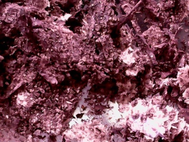
XXIX R-P-S Seminar 2020                                                                                                  IOP Publishing
IOP Conf. Series: Materials Science and Engineering              1015 (2021) 012052           doi:10.1088/1757-899X/1015/1/012052

Engineering and geological features of technogenic deposits
and cultural layers in the territory of Samara

                     D Vasilieva, M Baranova and A Maltsev
                     Department of Engineering Geology, Bases and Foundations, Samara State Technical
                     University, 244 Molodogvardeyskaya St., Samara, Russia, 443100

                     E-mail address: vasilievadi@mail.ru

                     Abstract. The engineering and geological features of technogenic deposits in the territory of the
                     city of Samara have been studied. Their features are revealed and a classification is carried out. The
                     article presents the results of a petrographic study of samples taken at the archaeological site of
                     Staraya Samara, Khlebnaya Square, carried out in 2019. The object represents cultural layers that
                     were formed in the XVIII-XIX centuries at the site of the alleged location of the second Samara
                     fortress. The studies were performed under a binocular microscope at an 8.75-fold magnification,
                     in the passing light of a polarization microscope at a 72-fold magnification, and under a digital
                     microscope at a 10-fold magnification. It has been determined that the pebble fraction is
                     represented by quartzite and jasper flint, the sandy and silty fractions are angular quartz fragments
                     with an admixture of undecomposed organic remains. Organic cultural layers, which reach 7-8
                     meters or more in the ancient part of the city, are especially powerful. Their presence is a limiting
                     factor in modern urban construction.

1. Introduction
The study of man-made deposits and ancient cultural layers of settlements and cities provides a large
amount of information about the first stages of settlement and use of the territory, about which few
written sources have survived. Involvement of the methods of natural sciences, including soil science
and geology, makes it possible to comprehensively consider the problems that people faced at the initial
stages of the development of the territory, and understand the ways to solve them. The study of the
history of changes in the geological environment under the influence of anthropogenic activity helps in
making forecasts of its development and, possibly, in preventing geoecological problems.

2. Methods
Much attention is currently being paid to the study of technogenic deposits and cultural layers, but it is
noted that their unified classification has not yet been created, which would take into account the
different conditions and factors of their formation of technogenic deposits, the peculiarities of the inflow
and transformation of technogenic material and the intensity of technogenic impact [1].
    Technogenic deposits are a specific genetic group of modern continental formations, the origin of
which is associated with practical human activity [2, 3]. The term "cultural layer" first appeared in the
scientific works of archaeologists, who used it to refer to layers or formations of rocks and soils that
have traces of ancient human activity and contain ancient artifacts [1]. The accumulation of cultural
layers occurs constantly in the course of human life on a certain territory – during the production of
earthworks, construction, landscaping, as well as during the accumulation of garbage.
    In the Samara region, technogenic landscapes predominate, of which 75.93% account for agricultural

              Content from this work may be used under the terms of the Creative Commons Attribution 3.0 licence. Any further distribution
              of this work must maintain attribution to the author(s) and the title of the work, journal citation and DOI.
Published under licence by IOP Publishing Ltd                          1
XXIX R-P-S Seminar 2020                                                                               IOP Publishing
IOP Conf. Series: Materials Science and Engineering     1015 (2021) 012052       doi:10.1088/1757-899X/1015/1/012052

landscapes; 6.72 % - urban landscapes, 1.32 % - industrial, including mining industrial landscapes [4].
On the territory of the city of Samara, the following technogenic deposits can be identified (table 1).
                       Table 1. Classification of technogenic sediments of the city of Samara.

       Complex                 Type                       Kind                              Variety
Bulk                  Construction           Soils of modern buildings       Loam and sandy loam with inclusions
                                                                             of building material
                                             Road soils and road             Carbonate crushed stone, gravel, sand
                                             embankments
                      Industrial             Waste of modern production Slag, ash
                      Household              Soils of modern and former      Loam with inclusions of brickwork,
                                             cemeteries                      stones, bones
                                             Cultivated soils of orchards    Loam, sandy loam, enriched with
                                             and vegetable gardens           humus
                                             Mixture of household and        Specially stacked or spontaneously
                                             household waste                 accumulated
                      Polygenic              Filled-in ravines               Loam, sand, organic deposits and
                                                                             variegated material
Sediments of          Sediments              Soils of floodplains of the     Alluvial sands
artificial reservoirs of a reservoir         Volga, Soka and Samara
                                             rivers

    Technogenic sediments are found throughout the Samara city, while the most ancient part of the city
is covered with a sedimentary sheath. Several zones can be distinguished on the urban territory:
    1) unchanged relief, which is not characterized by the formation of technogenic sediments;
    2) minimal changes in the relief, where the power of technogenic sediments does not exceed 1 m;
    3) the maximum change in the relief, with the power of technogenic sediments over 5-6 m.
    For the oldest part of the city Samara is characterized by the maximum change in relief and the
greatest thickness of technogenic sediments.
    The aim of the article is the study of the structure and engineering-geological peculiarities of
technogenic sediments and cultural layers in the most ancient part of the city Samara, the examples of
archaeological excavation at Khlebnaya Square and materials of a technical survey of the pavilion-cafe
on the territory of the River Station.
    Methods of scientific literature analysis, tabular and graphical methods were used in the research
process. With the help of generally accepted methods researches under a binocular microscope (at
magnification 8.75 times), in passing light of a polarization microscope (at magnification 72 times) and
under a digital microscope at magnification 10 times were carried out.

3. Results and discussions
The territory of the research object “Old Samara. Wooden structures, erected no later than the middle of
the XIX century ", located on the Khlebnaya square in the Samara district of the city Samara (figure 1).
Archaeological excavations of this object were carried out many times, starting in 2013, which made it
possible to obtain a large amount of data on the early stages of the settlement of Samara. Archaeological
research in 2019 was carried out by JSC Transenergoproekt (Saratov) on the basis of an open sheet of
V.V. Tikhonov. In the 2019 excavation, part of the slope of the second above-floodplain terrace of the
Samara river was uncovered.
   In geomorphological terms, the investigated territory represents the above-floodplain terraces of the
Samara and Volga rivers of different ages and complex structures, with a significant slope of the terrain
and gradually turning into the watershed surface [5].

                                                           2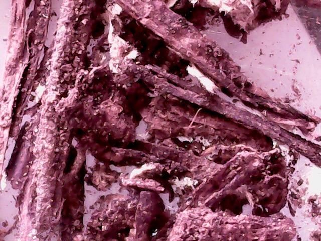
XXIX R-P-S Seminar 2020 IOP Publishing
IOP Conf. Series: Materials Science and Engineering 1015 (2021) 012052 doi:10.1088/1757-899X/1015/1/012052
Pavilion-cafe
Excavation at
Khlebnaya Square
Figure 1. The layout of the objects of research in the historical center of Samara.
For this territory, before the development and leveling of the surface, the following exogenous
geological processes were characteristic: ravines, planar erosion, landslides, flooding, etc. [6].
Gully formation is a very unfavorable exogenous geological process [7]. Most of the ravines belong
to ancient erosional incisions, and only some of them are the result of modern erosion [8-10]. Perhaps
it was to strengthen the construction site and prevent the activation of gully formation at the site of the
fortress that wooden structures were erected, uncovered by archaeological excavations in 2013-2014
and 2017.
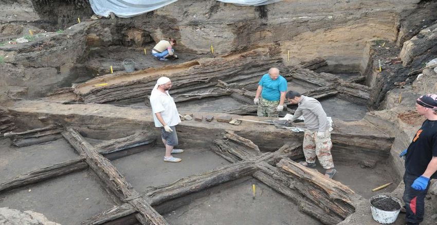
The 2019 excavation revealed the edge of the second terrace above the floodplain in Samara and a
sharp drop in the relief to the first terrace. To smooth out the unevenness of the relief from about 1722
(the date was determined from the coins found in the cultural layers), the lowered areas of the terrain
were backfilled with organic remains and construction debris. At present, the thickness of these layers
reaches 7-8 meters and more (figure 2).
Figure 2. General view of the archaeological excavation site of Khlebnaya Square in 2019.
3
XXIX R-P-S Seminar 2020 IOP Publishing
IOP Conf. Series: Materials Science and Engineering 1015 (2021) 012052 doi:10.1088/1757-899X/1015/1/012052
The cultural layers are located on the "mainland" - yellow ancient alluvial sand with a large number
of ferruginous interlayers. At present, we can observe a sharp change in the continental layer up to 3 m
high, which is completely planned by filling in organic cultural layers.
The pavilion-cafe object is located on the Volga river Embankment near the intersection of M.Gorky
and Pionerskaya streets in the Samara district of Samara. The technical condition survey was carried out
by employees of the Samara State Academy of Architecture and Civil Engineering (SamGASA) under
the guidance of one of the co-authors of this article. In structural terms, the object was a one-story frame
building made of metal elements, measuring 16 x 12 m in plan, operated only in the summer. The
purpose of the survey is the possibility of reconstructing the building and replacing the light metal frame
with capital brick walls for year-round operation of the cafe.
An analysis of the engineering-geological conditions of the pavilion-cafe site showed that, in
geomorphological terms, the surveyed area is confined to the left-bank floodplain of the river Volga.
Before the start of the Embankment construction, the absolute elevations of the natural relief were 30.1-
34.0 m. As a result of planning works by the method of soil filling during the construction of the river
station, the site currently has a flat surface with absolute elevations of 36.2-36.4 m with a weak slope in
the northwest direction towards the river Volga.
Based on the results of engineering-geological surveys in the soil massif of the site of the building
under study, 8 engineering-geological elements (IGE) were identified:
IGE-1 (tQIV) - bulk soil, packed, compacted, complex composition-a mixture of black soil (60%),
clay, sand, crushed stone, broken bricks and glass, with a capacity of 0.5 to 2.4 m;
IGE-2 (tQIV) - bulk soil, similar to IGE-1, with a manure content of up to 30%, with a thickness of
1.8 to 3.2 m;
IGE-3 (tQIV) - black manure, decomposed, with a content of black soil and sand up to 20%, up to 2.0
m thick;
IGE-4 (tQIV) - brown-brown bulk sand, medium size, dense and medium density with inclusions of
broken brick and glass, low moisture, up to 3.2 m thick;
IGE-5 (aQIV) - sand is dark gray, fine, medium density, moist, from a depth of 7.10 m from the
ground surface, water-saturated, slightly humus, with a thickness of 2.8 to 4.2 m;
IGE-6 (aQIV) - gray sandy loam, plastic, slightly humus, up to 1.6 m thick;
IGE-7 (eP2kz) - gray, highly weathered, loose dolomite, reduced strength, up to 3.4 m thick;
IGE-8 (eP 2kz) - grey dolomite, highly weathered, fractured, low-strength, with a thickness of 0.6 to
2.2 m.
The main indicators of soil properties are shown in table 2.
Table 2. Basic physical and mechanical properties soils the base.
Organic Deforma- Limit of Calculated
Soil Adhesive Internal
Number Name content, tion compressive resistance of
density power friction angle
IGE IGE in unit modulus strength the base soil
g/cm3 fractions E MPa
c kPa deg. RС MPa R0 kPa
1 Bulk soil 1.80 0.09 15 – – – 120
2 Bulk soil with a
1.75 0.20 7 – – – 100
manure to 30 %
3 Manure with a
content of black soil 1.50 0.40 3 – – – 50
and sand up to 20%
4 Bulk sand 1.80 – 30 0 34 – –
5 Sand fine 1.78 – 22 0 30 – –
6 Plastic sandy loam 1.87 – 10 10 20 – –
7 Dolomite strongly
weathered of 1.90 – 6 – – 4 –
reduced strength
8 Dolomite highly
weathered low- 2.20 – 35 – – 12 –
strength
4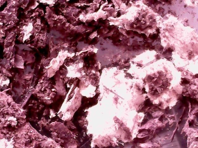
XXIX R-P-S Seminar 2020 IOP Publishing
IOP Conf. Series: Materials Science and Engineering 1015 (2021) 012052 doi:10.1088/1757-899X/1015/1/012052
The technical inspection of the object showed that the massif is represented by soils of different
thickness and character of bedding, significantly differing in their physical and mechanical characteristics.
Therefore, the base is characterized by heterogeneity and anisotropy of properties. Directly below sole of
the existing foundations, the bearing layer is bulk soil. In addition, the base to a depth of 4-6 m is
represented by various weak bulk soils (having low values of the design soil resistance in the range from
50 to 120 kPa), which are underlain by low-strength dolomites.
Most of the verification calculations showed that under the brick walls of the cafe building after its
reconstruction, a strip foundation with a width of 1 m and depth laying down of the bottom plane of the
foundation of 1.9 m, resting on bulk soils IGE-1, is sufficient. However, the presence of large amounts
of manure and chernozem (i.e. organic matters) in the weak underlying layers of the IGE-2 and IGE-3
base made it possible to classify these soils as biogenic and consider their stress-strain state as
unstabilized. The calculation for a weak underlying layer led to the fact that as the foundation for a small
one-story cafe, a foundation plate was recommended for the entire building with dimensions in the plan
of 18 × 14 m.
Therefore, the superstructure of existing and the construction of new multi-storey buildings in the
historical center of Samara is associated with the need to take into account the complex geological
conditions during construction. The presence of man-made and cultural layers, prone to heterogeneity
and anisotropy of the properties and texture of the soil massif, in most cases leads to uneven settlements
of the foundation under the load from the building. In addition, deformations of the base can be long in
time and the dependence of settlement on time is not always predictable.
The study of engineering and geological features of construction on the territory of Samara depends
on the physical and geographical conditions and geological structure, including stratigraphy, tectonics,
karst occurrences and the level of groundwater.
Back in 1969, the research of doctor of geological and mineralogical sciences V.I. Rachitsky [12] made
it possible to identify the engineering-geological area, confined to the high part of Samara from the street
Polevay to the Khlebnaya Square. It covers the territory of distribution of quaternary alluvial deposits of
the second above-floodplain ancient terrace at the confluence of the Volga and Samara rivers. The edges
of the terrace are lowered by denudation processes and, especially on the Samara slope, are poorly
expressed in the relief. This area, according to V.I. Rachitsky, composed of layered and cross-bedded
ancient quaternary alluvial sands and sandy loams up to 30 meters thick. Sands and sandy loams were very
well studied by V.I. Rachitsky from their physical and technical side (table 3).
Table 3. General characteristics of the properties of alluvial deposits.
Physical and mechanical properties of soils Loams Sandy loams Sands
Soil moisture, w , % 17.25 13.50 8.60
Degree of soil moisture, Sr , in unit fractions 0.75 0.30 0.30
Density of mineral particles, s , g/cm3 2.67 2.66 2.62
Soil density, , g/cm3 1.91 1.78 1.76
Porosity, n , %. 38.20 42.00 43.00
Porosity coefficient, e , in unit fractions 0.62 0.73 0.76
Humidity at the border of plasticity, wр , % 16.75 16.60 -
Plasticity number, Jp , % 10.85 3.86 -
Calculated ground resistance of the base at a
270.00 234.00 200.00
depth of 2 m, Ro , kPa
As follows from table 3 loam, sandy loam, and sand are partially suitable for construction.
The sand sequence is underlain by limestones and, more rarely, dolomites, and is partially suitable
for construction. But in general, a specific engineering-geological region is less favorable, since in this
region there are fears of encountering karst rocks of the Kazan tier. The groundwater level confined to
the Kazan aquifer is located at absolute elevations from 30 to 40 m.
The authors carried out a petrographic study of the material of samples taken from the continental layer
5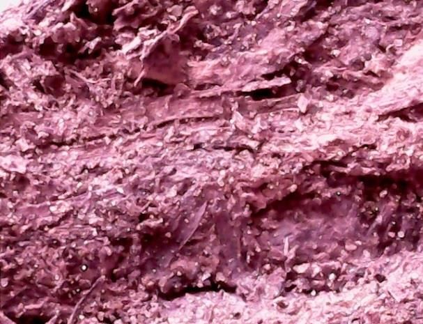
XXIX R-P-S Seminar 2020                                                                          IOP Publishing
IOP Conf. Series: Materials Science and Engineering   1015 (2021) 012052    doi:10.1088/1757-899X/1015/1/012052

and organic cultural layers. The research was carried out under binoculars at an 8.75-fold magnification,
in the passing light of a polarizing microscope at a 72-fold magnification, and under a digital microscope
at a 10-fold magnification. Generally accepted methods were used [13-18].
    Samples from the underlying "mainland" layer are represented by a weakly compacted bulk mass in
the amount of 2 kg. The color of the whole mass is brown. The sandy-siltstone fraction predominates, in
which there are single dense well-rounded pebbles.
    Pebble fraction. The shape of the fragments is slightly flattened elliptical, ranging in size from 5 to
20 mm. The surface is well smoothed with shallow indentations, dark brown to black in color. In the
cleavage, brown fragments have a conchoidal fracture, a light gray color with a faint creamy tint, and a
fine-grained structure. On the action of 10% hydrochloric acid solution, boiling is observed. The Mohs
hardness is 3, which indicates limestone. Black fragments in the cleavage also have a conchoidal
fracture, cherry-red color, structure from fine-grained to latent-crystalline. The Mohs hardness is slightly
above 6, indicating jasper-like flint (figure 3).
  A)                                                          B)

                         Figure 3. Photo of the pebble fraction (A-jasper flint, B-limestone).
    Sand-siltstone fraction. The sand fraction has a size from 0.1 to 0.8 mm. The predominant grain is
rounded with a strong glass luster, translucent in the passing light of a polarizing microscope, with a
refractive index close to 1.54, which indicates quartz. In smaller quantities, there are dark brownish non-
translucent angular fragments of the same size and large with a sliver-like elongated shape up to 3 mm
in size, which probably indicates soil and plant formations (figure 4). The siltstone fraction has a size
from 0.01 to 0.05 mm. Their shape is lamellar, angular. The composition is the same as in the sand
fraction, but dark dusty grains predominate (figure 5).

          Figure 4. Photo of the sand fraction.               Figure 5. Photo of the siltstone fraction.

                                                         6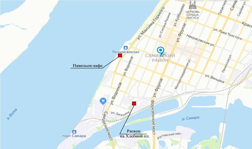
XXIX R-P-S Seminar 2020                                                                         IOP Publishing
IOP Conf. Series: Materials Science and Engineering   1015 (2021) 012052   doi:10.1088/1757-899X/1015/1/012052

    Samples from man-made deposits (organic cultural layers) are represented by a dense mass of dark
brown color with not clearly defined layering. When splitting, the mass easily splits into lumpy and
flattened fragments, in the cleavage of which there are intermittent and very thin layers of white color.
Cracks are observed in these layers (figure 6). The mass structure is porous granular-fibrous. The pore
configuration varies from incorrectly isometric to elongated in one direction (figures 6 and 7). Fine-
grained inclusions are present in the total mass, but elongated wood remains with preserved
microstructure predominate (figures 7 and 10). The contact of dense and uniformly porous layers is
observed in individual samples. Cracks are present in dense layers, and oval formations are present in
porous layers (figure 8).

                        Figure 6. Chipped surface with cracks and white interlayers.

                                  Figure 7. Treelike inclusions in a fine-grained mass.

                                 Figure 8. Contact of dense and porous layers.

                                                         7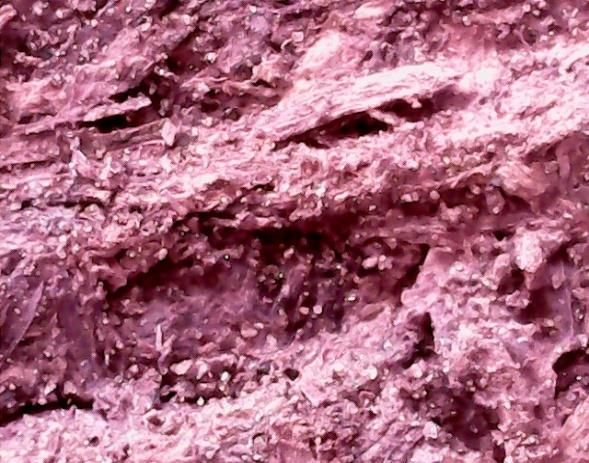
XXIX R-P-S Seminar 2020                                                                              IOP Publishing
IOP Conf. Series: Materials Science and Engineering   1015 (2021) 012052      doi:10.1088/1757-899X/1015/1/012052

   These formations are covered with a white crust, which have a mossy surface, possibly fungal
formations on oval inclusions of organic debris (figure 9). In the loose fraction, tree-like remains and
individual quartz grains are clearly distinguished (figure 10).

                                Figure 9. White formations on oval inclusions.

                  Figure 10. Plant residues and grains of transparent quartz in a loose fraction.
    Thus, at the initial stage of settling the territory of Samara, the settlers faced significant difficulties due
to the natural components of the landscape: high dissection and relief changes, loose sandy soils, active
erosion processes. At the location of the modern Khlebnaya Square, these problems were solved with the
help of the construction of wooden structures and the forming high-capacity of anthropogenic deposits of
high power from organic materials and construction waste.

4. Conclusions
As a result of the study, the following conclusions can be drawn:
    1. Technogenic deposits of Ancient Samara are characterized by a large thickness of organic cultural
layers (7-8 meters or more), compacted, having a layer-by-layer occurrence, a porous structure, with
remnants of wood and household waste.
    2. Natural ancient alluvial deposits in the form of sand, sandy loam and gravel are located as the
underlying rocks under the technogenic organic deposits.
    3. Engineering and geological features of technogenic sediments can complicate the use of the
territory for urban construction.

                                                         8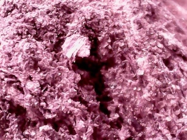
XXIX R-P-S Seminar 2020                                                                         IOP Publishing
IOP Conf. Series: Materials Science and Engineering   1015 (2021) 012052   doi:10.1088/1757-899X/1015/1/012052

References
[1] Kazdym A A 2014 Technogenic soils and technogenic deposits, technogenic landscapes and the
        cultural layer - modern problems of classification and taxonomy Soil science 1 pp 54-70
[2] Afonin A P, Dudler I V and Ziangirov R S et al. 1990 Classification of technogenic soils
        Engineering Geology 1 pp 115-21
[3] Petrenko S A and Koff G L 1989 Engineering-geological structure and engineering-geological
        typification of Moscow In: Engineering Geology and Hydrogeology of Moscow (Moscow:
        Institute of the Lithosphere of the USSR Academy of Sciences) pp 22-45
[4] Report on the state and use of land in the Samara region in 2018. Federal Service for State
        Registration, Cadastre and Cartography Directorate of the Federal Service for State
        Registration, Cadastre and Cartography for the Samara Region 2019 (Samara)
[5] Baranova M N and Vasilyeva D I 2016 Geological and geomorphological zoning on the territory
        of Samara Traditions and innovations in construction and architecture Construction (Samara:
        Samara State University of Architecture and Civil Engineering) pp 189-92
[6] Vasilyeva D I 2015 Geological conditions for the construction of the Samara fortress of the 18th
        century on the Khlebnaya square of the city of Samara Building a collection of articles
        “Traditions and innovations in construction and architecture” ed. M I Balzannikova and etc.
        (Samara: Samara State University of Architecture and Civil Engineering) pp 252-7
[7] Vasilyeva D I, Baranova M N and Pivovarova L V 2018 Ravines as a geoecological factor in the
        use of land in settlements Materials of the 7th international scientific-practical. Conf.
        “Bioecological local history: world, Russian and regional problems (Samara: SGSPU)
        pp 107-10
[8] Kovalev S N 2001 Gully erosion in urbanized areas Soil erosion and channel processes Release
        13 (Moscow: Moscow State University) pp 55-84
[9] Lyubimov B P and Kovalev S N 2006 Zonal and regional types of ravines Geomorphology 1
        pp 11-9
[10] Ibragimova S A and Kazantsev I V 2014 Characteristics of erosion processes on the territory of
        the Samara region Bulletin of the Samara Scientific Center of the Russian Academy of Sciences
        16 (1-1) pp 243-6
[11] Scientific and technical report on the topic: “Inspection of the technical condition of the building
        of the pavilion - a cafe located on the Embankment of the river Volga in the Samara region,
        Samara " 2000 (Samara: SamGASA)
[12] Rachitsky V I 1969 Engineering-geological zoning of the Kuibyshev region. Collection Geology,
        geochemistry and exploitation of oil fields (Kuibyshev: KPTI)
[13] Platonov M V and Tugarova M A 2004 Petrography of clastic and carbonate rocks: textbook
        Allowance (St. Petersburg: SPbGU) p 72
[14] Baranova M N and Maltsev A V 2015 Fundamentals of petrography of sedimentary rocks:
        Method instructions (Samara: SGASU) p 32
[15] Kostyuk V P 2002 Fundamentals of mineralogy and petrography: a course of lectures (Samara:
        SGASU) p 156
[16] Kochurova R N 1977 Fundamentals of Practical Petrography (Leningrad: Leningrad State
        University) p 176
[17] Naumov V A 1981 Optical determination of the components of sedimentary rocks (Moscow:
        Nedra) p 203
[18] Tatarsky V B 1965 Crystal optics and immersion method (Moscow: Nedra) p 306

                                                         9
You can also read