Ecological site F093AY006MN Depressional Wet Hardwood Forest
←
→
Page content transcription
If your browser does not render page correctly, please read the page content below
Natural Resources
       Conservation Service

                                  Ecological site F093AY006MN
                                Depressional Wet Hardwood Forest
                                                   Accessed: 06/27/2022

General information
Figure 1. Mapped extent

Areas shown in blue indicate the maximum mapped extent of this ecological site. Other ecological sites likely occur
within the highlighted areas. It is also possible for this ecological site to occur outside of highlighted areas if detailed
soil survey has not been completed or recently updated.

MLRA notes
Major Land Resource Area (MLRA): 093A–Superior and Rainy Stony and Rocky Till Plains and Moraines

The Superior Stony and Rocky Loamy Plains and Hills, Western Part is located and completely contained in
northeastern Minnesota (Figure 1). This area has both the highest and lowest elevations in the state, as well as
some of the state’s most rugged topography (Ojakangas and Matsch, 1982). The MLRA was glaciated by numerous
advances of the Superior, Rainy, and Des Moines glacial lobes during the Wisconsin glaciation as well as pre-
Wisconsin glacial periods. The geomorphic surfaces in this MLRA are geologically very young (i.e., 10,000 to
20,000 years) and dominated by drumlin fields, moraines, small lake plains, outwash plains, and bedrock-controlled
uplands (USDA-NRCS, 2006). There are thousands of lakes scattered throughout the region that were created by
these glacial events. Most of these lakes are bedrock-controlled in comparison to adjacent glaciated regions where
glacial drift deposits are much thicker and the lakes occur in depressions atop the glacial drift (Ojakangas and
Matsch, 1982). In contrast to adjacent MLRAs, the depth to the predominantly crystalline or sandstone bedrock in
MLRA 93A is relatively shallow because the most recent glacial events were more erosional than depositional
(Ojakangas and Matsch, 1982).

Classification relationships
Major Land Resource Area (MLRA): Superior Stony and Rocky Loamy Plains and Hills, Western Part (93A)

USFS Subregions: Northern Superior Uplands Section (212L); North Shore Highlands Subsection (212Lb)

Ecological site concept
Depressional Wet Hardwood Forests are widespread throughout the distribution of the Superior Lobe glacial
advance within MLRA 93A. These sites are developed primarily from low lying mineral soils, but can have up to
sixteen inches of organic surface. Parent materials include both till and outwash from Superior lobe deposits. They
occur on small to moderate sized closed depressions and shallow, low gradient drainage networks, surrounded by
an upland forest matrix. Ponding occurs throughout the spring and much of the early growing season. Later in the
growing season ponded usually recedes, but they will again pond during moderate to heavy rainfall events.
Hummocks from fallen trees create unique micro-topography, with micro-depressions that may hold water all year
and adjacent root wads that shed water. Soil texture is of limited importance since these sites are saturated nearly
all year.

Plant communities include an array of species that are adapted to periods of prolonged ponding and soil saturation.
Black ash (Fraxinus nigra) is the dominant tree species, along with northern white cedar (Thuja occidentalis). Yellow
birch (Betula alleghaniensis) is often an important component in the subcanopy. Both northern white cedar and
yellow birch find rooting medium in the aforementioned hummocks, created by fallen trees, and other large sized
downed woody debris, usually from fallen black ash or northern white cedar.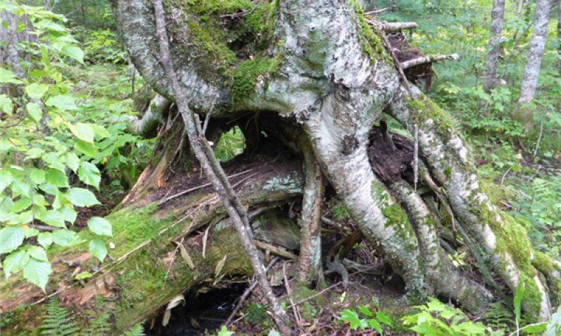
Relative to other forested wetland communities in the MLRA, Depressional Wet Hardwood Forests are
comparatively richer, and have a diverse assemblage of ground flora. Wetland species like yellow marsh marigold
(Caltha palustris), fowl mannagrass (Glyceria striata), are almost always present. Interestingly, the drier conditions
on hummocks allow a number of common upland species to persist. In contrast, the adjacent wet micro-
depressions often host obligate wetland species that are characteristic of more permanent wetlands.

Associated sites
F093AY013MN Till Upland Forest
            This ecological site is surrounded by upland soils and landforms. There are often rims of somewhat poorly
            and poorly drained soils of the same parent material adjacent to this site. To date, Till Upland Mesic
            Hardwood Forests (093AY001) is the only associated ecological site description developed in the MLRA.
            In some cases, these are isolated depressions that are completely surrounded by a Till Upland Mesic
            Hardwood Forest matrix. In other cases, shallow drainageways meander back-and-forth through many
            adjacent ecological sites.

Table 1. Dominant plant species

Tree           (1) Fraxinus nigra
               (2) Thuja occidentalis
Shrub          (1) Alnus incana
               (2) Acer spicatum
Herbaceous (1) Glyceria striata
           (2) Caltha palustris

Physiographic features
Wet Depressional Hardwood Forests are located on end moraines, ground moraines, outwash plains and inter-
drumlins associated with the Automba and Nickerson phases of the Superior Lobe glacial advance (Table 1). The
most common landforms are ponded depressions and subtle, concave areas. They can also occur in shallow, low
gradient drainageways that may receive concentrated flow (e.g., incipient drainage ways). Slope shape can be
either linear or concave up slope, and is always concave across slope. Individual sites can be quite small in size,
ranging from less than one acre, to ten acres. These sites are ponded throughout the spring and early summer
months, and generally dry out by August, and pond again in low to moderate rain events. During dry times the water
table is generally within 10 inches, but can be as low as 24 inches. These sites receive runoff and lateral subsurface
flow from adjacent, upslope ecological sites. They also produce runoff and lateral subsurface flow downslope, to
streams, rivers, and large peatland basins. Elevation is mainly above 1,000 feet and below 1,600 feet.

Table 2. Representative physiographic features

Landforms              (1) Depression
                       (2) Drainageway
Flooding frequency None
Ponding duration       Brief (2 to 7 days) to very long (more than 30 days)
Ponding frequency Occasional to frequent
Elevation              1,000–1,600 ft
Slope                  0–1%
Ponding depth          0–6 in
Water table depth      0–24 in
Aspect                 Aspect is not a significant factor

Climatic features
The average freeze-free period of this ecological site is about 140 days, and ranges from 131 to 149 days (Table 2).
Average annual precipitation is 32 inches, which includes rainfall plus the water equivalent from snowfall. About 65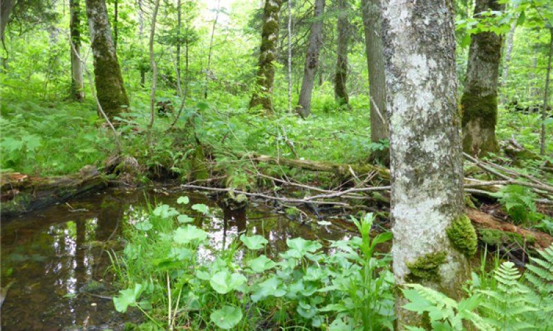
percent of the precipitation falls as rain during the growing season (from May through September), and about 21
percent falls as snow (Table 3). Most of the spring snowmelt runs off the steeply sloping or high relief surfaces into
high gradient drainageways and then into wetlands, streams or lakes. Most of the rainfall during the growing season
is transpired by plants, which leaves a small proportion of the total precipitation for deep aquifer recharge. Much of
the distribution of this ecological site is located in the highlands above Lake Superior which receive the most
snowfall in Minnesota, averaging over 70 inches annually (Flaccus and Ohmann, 1964; MN DNR, 2013a). This lake
effect snow is the result of warm, moist air rising and moving inland from the lake, ultimately cooling to produce
localized snowfall (Anderson and Fischer, 2015; MN DNR, 2013a). The average annual low and high temperatures
are 28 and 48 degrees Fahrenheit, respectively (Table 3). Frost pockets and of cold air drainage from above make
this ecological site colder and wetter than adjacent ecological sites (SNF, unpublished report a, b). As a result,
snow and frost remain longer in the spring, thus resulting in shorter growing seasons than the adjacent uplands.
Climate data and analyses are derived from 30-year averages gathered from four National Oceanic and
Atmospheric Administration (NOAA) weather stations contained within the range of this ecological site, but were not
necessarily located on correlated map units (Table 4).

Table 3. Representative climatic features

Frost-free period (average)       119 days
Freeze-free period (average) 139 days
Precipitation total (average)     34 in

Climate stations used
  (1) LUTSEN 3NNE [USC00214918], Lutsen, MN
  (2) WOLF RIDGE ELC [USC00219134], Finland, MN
  (3) DULUTH [USW00014913], Duluth, MN

Influencing water features
These sites can be incipient drainage networks, with small perennial streams, or they can be in closed, isolated
depressions. Seasonal ponding is most prominent during March through June and October through November.
Water tables and water table recharge closely mimics annual rainfall graphs. They are either at or above the surface
much of the year, and may drop to a low of low of 12 inches during the dry months. In addition to precipitation
inputs, these sites receive surface and subsurface water from surrounding sites. They also discharge water to lower
elevation ecological sites, and ultimately to rivers, lakes, or large peatland basins. In these relatively young morainic
landscapes, well established dendritic drainage networks have not yet been developed. Instead, these sites exhibit
water flow though after significant rainfall events. Landforms behave like closed depressions until an overflow
threshold is achieved, wherein they begin to behave like drainageways. It is a complex interaction that is dependent
upon factors like relative elevation and degree of incision. Stream orders associated with these sites are first,
second, third, and fourth (SNF, unpublished report b). These sites also provide deep percolation for water table
recharge.

Depressional Wet Hardwood Forests are classified as a Palustrine System, Forested Wetland Class, and
depending on the State of vegetation, either a Broadleaf Deciduous or Dead Subclass, as described by Cowardin et
al. (1979).

Soil features
The parent material for these soils includes coarse-loamy and fine-loamy till, as well as outwash, from the Superior
lobe glacial advance (Table 5). Although these are primarily mineral soils, up to 16 inches of organic parent material
may be on the surface. On a given site, organic deposits (if existing) will be thickest near the center of the landform.
In some cases there may be deeper organic surfaces that classify as true Histosols , but this is not typical condition
of these landforms, and may be a relic of a past climatic or hydrologic time period. These soils are ponded, and as
a result, are very poorly drained. However, wetness varies seasonally on these soils, which is a primary site factor
defining this ecological site. Due to concave landforms and very poorly drained and ponded soils, soil textural
classes are not a significant site factor for vegetation. Surface texture is loam or sandy loam, and subsurface
textures range from loam to very gravelly coarse sand. Soil pH on contributes to the rich nature of these plant
communities, and ranges from 5.5 (moderately acid) to 6.5 (slightly acid), which is relatively high when compared to
other wetland ecological sites in the MLRA. Soil orders are Inceptisols, and taxonomic classes are either Typic or
Histic Humaquepts. Giese, Twig, Wahbegon, and Hulligan are all representative soil series for this ecological site.

Table 4. Representative soil features

Parent material                         (1) Ablation till–gabbro
                                        (2) Outwash–sandstone
                                        (3) Lodgment till –basalt
Surface texture                         (1) Very gravelly loam
                                        (2) Sandy loam
Family particle size                    (1) Loamy
Drainage class                          Very poorly drained
Permeability class                      Slow to rapid
Soil depth                              80 in
Surface fragment cover
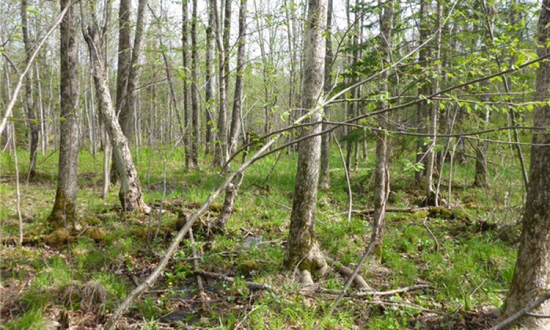
mature windthrown trees (MN DNR, 2014; Landfire, 2007; Gucker, 2005). Tree species common to this ecological
site have shallow and spreading root systems, which is further exacerbated by a limited rooting zone resulting from
frequent high water tables. As canopy trees reached the dominant canopy class they became more susceptible to
these smaller scale, often microburst, wind events. Black ash are especially susceptible to this this type of
windthrow (MN DNR, 2011; Wright and Rauscher, 1990). Climatic variation, both in terms of drought as well as
excess precipitation, interacted with wind events to develop these canopy openings, whereby drought and extended
ponding stressed trees to the point of being susceptible to disease and overall decline, and weakened their ability to
withstand strong winds. These fine to moderate scale windthrow events likely occurred on an average 110 year
rotation and possibly as frequent as 40 years (MN DNR, 2014; Landfire, 2007).

Currently, the dynamics of plant communities in this ecological site are similar to what they were historically.
Although these sites are broadly distributed, they are generally small in size, and are part of a broader matrix of
various upland forest types. As a result, they weren’t affected as much as some forest types during the logging era
following European settlement. There is some reference of early settlers using black ash as firewood, but it was
probably used on a small scale and local basis (MN DNR, 2011). In some regions, northern white cedar and other
softwoods were selectively logged, leaving monotypic black ash stands. Consequently, while black ash has always
been dominant on these sites, it is possible that their abundance has increased during the last Century. Overall,
these sites were largely left undeveloped, and a majority of Depressional Wet Forest ecological sites closely
resemble communities described in the Reference State (Figure 2).

In general, alteration of natural hydrology is probably the most important driver of state change in this ecological
site. Damming waterways backs up water and produces near permanent flooding, transitioning sites to open water
wetlands. This can happen naturally as a result of beaver (Castor canadensis) activity, or as a result of human
development (primarily road building). In some cases, road building activities can also block the flow of water to
these sites, drying them out. This condition has not been documented within the MLRA, but it is surmised that such
a condition would result in unique and novel plant communities. Another way hydrology can be altered is by the
complete loss of forested canopy, which can cause significant alterations in effective transpiration of water, resulting
in consistently higher water tables, and ultimately to a non-forested state (Mitsch and Gosselink, 2007; Palik et al.,
2012; Erdmann et al., 1987). These situations result similar hydrology found in shrub swamps and wet meadows.
This can result from poor silvicultural practices, extreme wind events, or significant insect or disease outbreaks.

Average site index at base age 50 for black ash averaged 46 feet, and ranged between 42 and 54. Site index curves
were developed by Carmean (1978). This is relatively low for black ash in comparison to sites in some upland
forests, which can be as high as 80 (Carmean, 1989). There may be some differences in productivity, species
composition, or response to disturbance on small, isolated depressions compared to shallow drainage networks. It
has been noted that a higher abundance of bluejoint, less structural development of the overstory, and less black
ash regeneration occur in these situations (Chel Anderson, MN DNR Ecologist, personal communication). This may
be related to dense till and perching of water. More research is needed to determine if there are significant
differences.

State and transition model
Figure 6. State-and-transition diagram.

State 1
Reference State
Community phases within the Reference State are related to scattered small and moderate sized canopy openings
from dead and/or windthrown trees. Windthrown trees are primarily dominant, above the canopy, and more
exposed to wind events. These trees, with shallow root systems, were likely previously weakened by either
excessive drought or ponding, leaving them open to attack by forest pests (MN DNR, 2014). Standing dead trees
from excessive ponding or drought may also provide these canopy openings. An estimated rotation of such events
is 110 years (MN DNR, 2014; MN DNR, 2005). This produced a patchwork of young and mature forests, all
dominated by black ash. Black ash is fairly shade tolerant as a seedling, and is often the only advanced
regeneration present in the understory, and thus it tends to replace itself in many situations (Gucker, 2005;
Erdmann et al., 1987). Black ash is also a long-lived species and can live to over 250 years old (Gucker, 2005).
Without larger openings, structure and composition of mature stands can be nearly perpetual, and gradually
regenerate new trees via small, one to many tree sized openings (Table 7). As a result of rather frequent, small
scale openings, stands do not often become old growth (i.e., greater than 135 years; MN DNR, 2014). But in cases
where they do, canopy structure is complex, and generally includes a component of long-lived and more shade
tolerant white spruce and balsam fir.

Northern white cedar and yellow birch often find their primary rooting substrate on downed woody debris associated
with these openings. Both species regenerate well on mossy, rotting wood (i.e., nurse logs) that have consistent
moisture (Smith, 2008 Erdmann, 1990; Johnston, 1990). Eventually, initial rooting media from downed woody
debris can leave roots exposed to air and result in poorly formed trees (Figure 3). Northern white cedar can also
regenerate by vegetation reproduction. These stems usually are developed from fallen trees and root from branches
that come in contact with moist rooting media and are extremely shade tolerant (Erdmann, 1990). Hummocks and
micro depressions resulting from windthrown trees are an important component of the Reference State. This
variability in microsites provides opportunity for obligate wetland species in ponded micro depressions and upland
species on the drier hummocks.

Today, much of the distribution of this ecological site is in community phases very similar those in the Reference
State.

Community 1.1
Mature Forest

Figure 7. Reference State (Community Phase 1.1 Mature Forest

Figure 8. Photo of a yellow birch with aerial roots, rooted

By stand age 75, a more characteristic, closed canopy and multi-tiered forest structure begins to develop (Table 8;
Figure 4). Stands are initially dominated by black ash, but regeneration opportunities for northern white cedar,
yellow birch, and white spruce begin to increase as the forest ages (Table 9). Also during this time, a build-up of
down woody debris accumulates, as well as the characteristic hummocks and adjacent micro-depressions begin to
increase micro-topography, and provide more sites for a diversity of ground flora species. Many sites will be
essentially self-sustaining at this point, with periodic canopy openings keeping stands from attaining old growth
status.

Table 5. Soil surface cover
Tree basal cover                            1-10%
 Shrub/vine/liana basal cover                4-13%
 Grass/grasslike basal cover                 9-15%
 Forb basal cover                            20-40%
 Non-vascular plants                         5-20%
 Biological crusts                           0%
 Litter                                      10-30%
 Surface fragments >0.25" and
Figure 9. Reference State (Community Phase 1.2 Young Forest)

The initiation of stand development follows partial canopy loss by windthrow or canopy openings developed from
pocket of dead trees (Figure 5). Black ash advanced regeneration is the dominant regenerating tree, but is
accompanied by other hardwoods, such as paper birch, balsam poplar (Populus balsamea), or quaking aspen
(Populus tremuloides). Increased light also favors some wetland shrubs and ground flora, particularly speckled
alder and bluejoint. Co-dominant canopy trees generally reach a diameter of around eight inches before
transitioning to a mature forest.

Pathway 1A
Community 1.1 to 1.2

Mature Forest                 Young Forest

Stand-levelling disturbance or small areas of partial canopy openings from wind or dead trees.

Pathway 2A
Community 1.2 to 1.1

Young Forest                  Mature Forest

Succession (75+ years without disturbance).

State 2
Flooded State
The Flooded State develops as a result of dammed or blocked waterways. Flooding is caused primarily by either
beaver activity or development associated with road building. Only drainageway landforms are affected, and
isolated depressions do not go through this state. Sites that have blocked water drainage from roads may become
perpetual open water wetlands. In natural settings, the Flooded State can last for many years, but it ultimately
depends on maintenance of high quality habitat conditions for beaver to proliferate. Once a site is abandoned,
dams will gradually decline and ultimately drain, thereby beginning the transition to the Non-Forested State.

Beaver populations in North America were drastically reduced by broad scale fur trapping during the Colonial time
period, into the 1800s (Mitsch and Gosselink, 2007). As a result, natural conversion of these sites to the Flooded
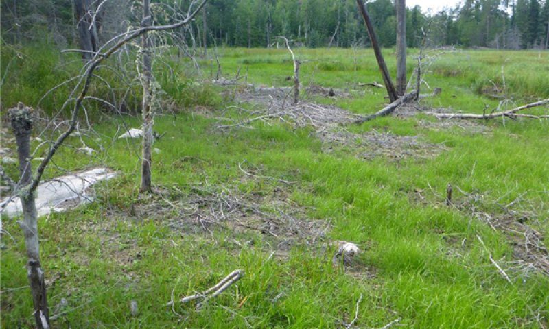
State may be less common today than it was prior to European settlement.

Community 2.1
Open Water Wetland

Figure 10. Flooded State of a black ash depression, similar t

The only community phase in this state is characterized as having dead or dying overstory trees, flooded by up to
several feet of essentially permanent water (Figure 6). Depending on depth of water, there will be areas with
emergent aquatic vegetation, as well as scattered areas of marsh-like conditions.

State 3
Non-Forested State
Sites can transition to this state by relatively sudden and complete loss of the tree canopy, thereby losing the
transpiration of water from trees needed to keep water tables at bay and allow tree species to continually
proliferate. This can happen as a result of intensive logging, forest pests, or general forest decline. This state will
likely become common in the MLRA if the invasion of the exotic emerald ash borer (Agrilus planipennis) beetle is
not halted (Slesak et al., 2014; Palik et al., 2012).

Sites can also transition to this state from the Flooded State, following drainage of backed up water from beaver
activity or road building. Initially, sites are wet meadows dominated by graminoids (e.g., bluejoint and sedges),
eventually becoming invaded by wetland shrubs depending on level of ponding and soil saturation. These sites may
have different soil characteristics depending on the extent and depth of sedimentation, which is largely dependent
on how long the site was dammed (Naiman et al., 2005)and is also related to nearby land use and landscape-level
soil geomorphology. More research is needed on how soil properties change following long term flooding from
blocked hydrology.

Other than a few scattered trees, these sites do not seem to regenerate trees well. Transition to the Reference
State is relatively unknown, and will require long term ecological succession over the course of many decades.
There is limited evidence that these communities succeed to a forested structure within a reasonable time frame
(SNF, unpublished report b). Non-forested wetland conditions may persist for decades, and even centuries (Naiman
et al., 2005; Terwilliger and Pastor, 1999). Viability of black ash seeds is only 8 years (Wright and Rauscher, 1990),
so seeds are probably at least initially extirpated from the site. And since most sites are small and isolated, there
may not be a reliable seed source nearby. The loss of important mycorrhizal relationships may also impede
succession of forest trees. It has been shown that long-term flooding kills mycorrhizae that form essential
relationships with tree species in other types of forested wetlands in the region, and recolonization following
draining may be inhibited (Anderson and Fischer, 2015; Terwilliger and Pastor, 1999), which may be the case in this
ecological site as well. All of this, in combination with extreme competition with resident vegetation, make
succession to a forested state difficult.

Community 3.1
Shrub Swamp
Figure 11. Non-Forested State similar to Community Phase 3.1

In this phase, shrubs are greater than 25% cover (Figure 7; MN DNR, 2005). Dominant species are speckled alder,
redosier dogwood, and willows (Salix spp.). Bluejoint and a variety of sedges are also dominant, along with a
myriad of sun-loving wetland forb species. There may be scattered trees as well, but they comprise low cover and
are not significant to the overall structure of the plant community. With a continued lowering of the water table, it is
possible for this phase to succeed to the Reference State if black ash and other trees can successfully establish.

Community 3.2
Wet Meadow

Figure 12. Non-Forested State similar to community Phase 3.2

In this phase, shrubs are less than 25% cover (Figure 8; MN DNR, 2005). Bluejoint, sedges, and a variety of sun-
loving wetland forbs dominate this phase. Lake sedge (Carex lacustris), the hummock-forming tussock sedge (C.
stricta), and beaked sedge (C. utriculata) are the most common sedges, and can be dominant (MN DNR, 2005).
The most common shrubs are speckled alder, redosier dogwood, and willows. There may be scattered trees as
well, but they comprise low cover and are not significant to the overall structure of the plant community.

Pathway 1A
Community 3.1 to 3.2

Shrub Swamp                    Wet Meadow

Increased ponding, soil saturation.
Pathway 2A
Community 3.2 to 3.1

Wet Meadow                  Shrub Swamp

Decreased ponding, soil saturation.

State 4
Non-Forested State
Sites can transition to this state by relatively sudden and complete loss of the tree canopy, thereby losing the
transpiration of water from trees needed to keep water tables at bay and allow tree species to continually
proliferate. This can happen as a result of intensive logging, forest pests, or general forest decline. This state will
likely become common in the MLRA if the invasion of the exotic emerald ash borer (Agrilus planipennis) beetle is
not halted (Slesak et al., 2014; Palik et al., 2012).

Sites can also transition to this state from the Flooded State, following drainage of backed up water from beaver
activity or road building. Initially, sites are wet meadows dominated by graminoids (e.g., bluejoint and sedges),
eventually becoming invaded by wetland shrubs depending on level of ponding and soil saturation. These sites may
have different soil characteristics depending on the extent and depth of sedimentation, which is largely dependent
on how long the site was dammed (Naiman et al., 2005)and is also related to nearby land use and landscape-level
soil geomorphology. More research is needed on how soil properties change following long term flooding from
blocked hydrology.

Other than a few scattered trees, these sites do not seem to regenerate trees well. Transition to the Reference
State is relatively unknown, and will require long term ecological succession over the course of many decades.
There is limited evidence that these communities succeed to a forested structure within a reasonable time frame
(SNF, unpublished report b). Non-forested wetland conditions may persist for decades, and even centuries (Naiman
et al., 2005; Terwilliger and Pastor, 1999). Viability of black ash seeds is only 8 years (Wright and Rauscher, 1990),
so seeds are probably at least initially extirpated from the site. And since most sites are small and isolated, there
may not be a reliable seed source nearby. The loss of important mycorrhizal relationships may also impede
succession of forest trees. It has been shown that long-term flooding kills mycorrhizae that form essential
relationships with tree species in other types of forested wetlands in the region, and recolonization following
draining may be inhibited (Anderson and Fischer, 2015; Terwilliger and Pastor, 1999), which may be the case in this
ecological site as well. All of this, in combination with extreme competition with resident vegetation, make
succession to a forested state difficult.

Transition 1
State 1 to 2
Flooding, backed up water from beaver dam or road bed.

Transition 1B
State 1 to 3
Removal of tree canopy resulting in loss of transpiration and elevated water levels.

Transition 2A
State 2 to 3
Drainage of open water.
Restoration pathway 3A
State 3 to 1
Long term forest succession.

Transition 3A
State 3 to 2
Flooding, backed up water from beaver dam or road bed.

Additional community tables
Table 8. Community 1.1 forest overstory composition

Common                                                            Height    Canopy Cover    Diameter
Name             Symbol   Scientific Name             Nativity       (Ft)            (%)         (In) Basal Area (Square Ft/Acre)

Tree
black ash        FRNI     Fraxinus nigra              Native      16–80           50–75         8–15                            –
arborvitae       THOC2 Thuja occidentalis             Native      16–50            5–25        12–20                            –
yellow birch     BEAL2 Betula                         Native      16–40            5–25         5–10                            –
                       alleghaniensis
balsam fir       ABBA     Abies balsamea              Native      16–40             1–5          3–8                            –
white spruce     PIGL     Picea glauca                Native      16–40             1–5          3–8                            –

Table 9. Community 1.1 forest understory composition

Common Name                      Symbol      Scientific Name                               Nativity Height (Ft)   Canopy Cover (%)

Grass/grass-like (Graminoids)
fowl mannagrass                  GLST        Glyceria striata                              Native       0.1–3              10–50
bluejoint                        CACA4       Calamagrostis canadensis                      Native       0.1–3              10–50
bluejoint                        CACA4       Calamagrostis canadensis                      Native       0.1–3              10–50
bristlystalked sedge             CALE10 Carex leptalea                                     Native       0.1–2                5–15
greater bladder sedge            CAIN12      Carex intumescens                             Native       0.1–2                1–10
awlfruit sedge                   CAST5       Carex stipata                                 Native       0.1–1                1–10
graceful sedge                   CAGR2       Carex gracillima                              Native       0.1–1                1–10
softleaf sedge                   CADI6       Carex disperma                                Native       0.1–1                1–10
fringed brome                    BRCI2       Bromus ciliatus                               Native       0.1–2                 1–5
Forb/Herb
yellow marsh marigold            CAPA5       Caltha palustris                              Native       0.1–1              10–50
northern bugleweed               LYUN        Lycopus uniflorus                             Native       0.1–1                5–25
dwarf red blackberry             RUPU        Rubus pubescens                               Native       0.1–1                5–15
blue skullcap                    SCLA2       Scutellaria lateriflora                       Native       0.1–1                5–15
touch-me-not                     IMPAT       Impatiens                                     Native       0.1–3                5–15
purplestem aster                 SYPUP       Symphyotrichum puniceum var. puniceum         Native       0.1–3                5–15
parasol whitetop                 DOUMU Doellingeria umbellata var. umbellata               Native       0.1–3                1–10
wild sarsaparilla                ARNU2       Aralia nudicaulis                             Native       0.1–2                 1–5
starflower                       TRBO2       Trientalis borealis                           Native       0.1–1                 1–5
arctic sweet coltsfoot           PEFR5       Petasites frigidus                            Native       0.1–1                 1–5
spotted joe pye weed             EUMA9       Eutrochium maculatum                          Native       0.1–3                 1–5
naked miterwort                  MINU3       Mitella nuda                                  Native       0.1–1                 1–5
naked miterwort MINU3 Mitella nuda Native 0.1–1 1–5 harlequin blueflag IRVE2 Iris versicolor Native 0.1–2 1–5 tall bluebells MEPA Mertensia paniculata Native 0.1–1 1–5 woodland horsetail EQSY Equisetum sylvaticum Native 0.1–1 1–5 threeleaf goldthread COTR2 Coptis trifolia Native 0.1–1 1–5 Jack in the pulpit ARTR Arisaema triphyllum Native 0.1–2 1–5 small enchanter's nightshade CIAL Circaea alpina Native 0.1–1 1–5 giant goldenrod SOGI Solidago gigantea Native 0.1–3 1–5 eastern swamp saxifrage SAPE8 Saxifraga pensylvanica Native 0.1–2 1–5 wood anemone ANQU Anemone quinquefolia Native 0.1–1 1–5 Canada mayflower MACA4 Maianthemum canadense Native 0.1–1 1–5 bunchberry dogwood COCA13 Cornus canadensis Native 0.1–1 1–5 purple meadow-rue THDA Thalictrum dasycarpum Native 0.1–3 1–2 Fern/fern ally common ladyfern ATFI Athyrium filix-femina Native 0.1–2 5–25 intermediate woodfern DRIN5 Dryopteris intermedia Native 0.1–1 5–15 sensitive fern ONSE Onoclea sensibilis Native 0.1–2 5–15 western oakfern GYDR Gymnocarpium dryopteris Native 0.1–1 1–5 ostrich fern MAST Matteuccia struthiopteris Native 0.1–3 1–5 long beechfern PHCO24 Phegopteris connectilis Native 0.1–1 1–5 Shrub/Subshrub speckled alder ALINR Alnus incana ssp. rugosa Native 1–16 25–75 redosier dogwood COSE16 Cornus sericea Native 1–10 1–15 beaked hazelnut COCO6 Corylus cornuta Native 1–10 1–15 American fly honeysuckle LOCA7 Lonicera canadensis Native 1–5 1–5 American cranberrybush VIOPA2 Viburnum opulus var. americanum Native 1–5 1–5 red currant RITR Ribes triste Native 1–5 1–5 Tree mountain maple ACSP2 Acer spicatum Native 1–16 5–25 American red raspberry RUID Rubus idaeus Native 1–10 1–15 black ash FRNI Fraxinus nigra Native 1–10 1–15 chokecherry PRVI Prunus virginiana Native 1–10 1–5 Inventory data references A total of 12 integrated plots, ranging from Tier 2 to Tier 3 intensity, were used as a basis for this ecological site. Three of these were Type Locations representing the data-supported Community Phase 1.1 in the state-and- transition model (Figure 2), and included all necessary data elements for a Tier 3 dataset (Table 10). No other community phases were supported with quantitative data analysis. All 12 plots had soil pedon and site data collected by a professional soil scientist using a form equivalent to SF-232. Pits were hand-dug using spade shovels, sharpshooters, and/or bucket augers. Of the 12 plots, two were located at established MN DNR relevé points, obtained and used with permission from the MN DNR County Biological Survey. List of MN DNR relevé plots used with verified soils data: 3475 and 8301. Other references Anderson, C.E. and Adelheid Fischer 2015. North Shore: A Natural History of Minnesota’s Superior Coast. University of Minnesota Press. Minneapolis, MN.
Carmean, W.H. 1978. Site Index Curves for Northern Hardwoods in Northern Wisconsin and Upper Michigan.
USDA For. Serv. Research Paper NC-160. St. Paul, MN.

Carmean, W.H., J.T. Hahn, and R.D. Jacobs. 1989. Site Index Curves for Forest Tree Species in the Eastern United
States. USDA For. Serv. Gen. Tech. Rep. NC-128. St. Paul, MN.

Cowardin, L. M., V. Carter, F. C. Golet, and E.T. LaRoe. 1979. Classification of Wetlands and Deepwater Habitats
of the United States. FWS/OBS-79/31, U.S. Department of Interior-Fish and Wildlife Service, Washington, D.C.

Erdmann, G.G. 1990. Yellow Birch. In: Silvics of North America, Vol 2, Burns, R.M., and B.H. Honkala (tech cords).
USDA For. Serv. Handb. 654, Washington, DC.

Erdmann, G.G., T.R. Crow, R.M. Peterson, Jr., and C.D. Wilson. 1987. Managing Black Ash in the Lake States.
USDA For. Serv. Gen. Tech. Rep., NC-115.

Flaccus, E. and L.F. Ohmann. 1964. Old-growth Northern Hardwood Forests in Northeastern Minnesota. Ecology
45:3, 448-459.

Gucker, C.L. 2005. Fraxinus nigra. In: Fire Effects Information System, [Online]. USDA For. Serv. Rocky Mountain
Research Station, Fire Sciences Laboratory. Available online at http://www.fs.fed.us/database/feis/; last accessed
January 3, 2014.

Johnston, W.F. 1990. Northern White Cedar. In: Silvics of North America, Vol 2, Burns, R.M., and B.H. Honkala
(tech cords). USDA For. Serv. Handb. 654, Washington, DC.

Landfire. 2007. Biophysical Setting 4114810 Laurentian-Acadian Alkaline Conifer-Hardwood Swamp. In: Landfire
National Vegetation Dynamics Models. USDA For. Serv. and U.S. Department of Interior. Washington, DC.

Minnesota Department of Natural Resources. 2014. WFn64 – Northern Very Wet Ash Swamp: Natural Disturbance
Regime, Stand Dynamics, and Tree Behavior. Available online at
http://files.dnr.state.mn.us/forestry/ecssilviculture/plantcommunities/WFn64.pdf; last accessed November 11, 2014.

Minnesota Department of Natural Resources. 2013a. Climate – Frequently Asked Questions. Available online at
http://www.dnr.state.mn.us/climate/faqs.html; last accessed December 11, 2013.

Minnesota Department of Natural Resources. 2011. Ash Management Guidelines for Private Forest Landowners.
University of Minnesota Extension. St. Paul, MN.

Minnesota Department of Natural Resources. 2005. Field Guide to the Native Plant Communities of Minnesota: the
Laurentian Mixed Forest Province. Ecological Land Classification Program, Minnesota County Biological Survey,
and Natural Heritage and Nongame Research Program. St. Paul, Minnesota.

Minnesota Division of Forestry. 2013. Minnesota Department of Natural Resources Tamarack Assessment Project.
Available online at http://files.dnr.state.mn.us/forestry/ecssilviculture/policies/tamarackAssessmentProject2013.pdf;
last accessed November 11, 2014.

Mitsch, WJ. and J.G. Gosselink. 2007. Wetlands, fourth ed. John Wiley & Sons, Inc. New York, NY.

Naiman, R.J., H. Dècamps, and M.E. McClain. 2005. Riparia: Ecology, Conservation, and Management of
Streamside Communities. Elsevier Academic Press. San Diego, CA.

NatureServe. 2013a. Associations and Alliances of USFS Section 212L in Minnesota. NatureServe, St. Paul,
Minnesota.

NatureServe. 2013b. Ecological Systems of USFS Section 212L in Minnesota. NatureServe, St. Paul, Minnesota.

Ojakangas, R.W. and C.L. Matsch. 1982. Minnesota’s Geology. University of Minnesota Press. Minneapolis, MN.
Palik, B.J., M.E. Ostry, R.C. Venette, and E. Abdela. 2012. Tree Regeneration in Black Ash (Fraxinus nigra) Stands
Exhibiting Crown Dieback in Minnesota. Forest Ecol. Mgmt. 269: 26-30.

Slesak, R.A., C.F. Lenhart, K.N. Brooks, D.W. D'Amato, and B.J. Palik. 2014. Water Table Response to Harvesting
and Simulated Emerald Ash Borer Mortality in Black Ash Wetlands in Minnesota, USA. Can. J. Forest Res. 44:961-
968.

Smith, W.R. 2008. Trees and Shrubs of Minnesota. University of Minnesota Press. Minneapolis, MN.

Superior National Forest. Unpublished report(a).
Superior National Forest Ecological Landtype Descriptions. USDA For. Serv. Duluth, Minnesota.

Superior National Forest. Unpublished report(b). Superior National Forest Ecological Landtype Phase Descriptions.
USDA For. Serv. Duluth, Minnesota.

Terwilliger, J. and J. Pastor. 1999. Small Mammals, Ectomycorrhizae, and Conifer Succession in Beaver Meadows.
Oikos 85: 83–94.
United States Department of Agriculture (USDA),

Natural Resources Conservation Service. 2006. Land Resource Regions and Major Land Resource Areas of the
United States, the Caribbean, and the Pacific Basin. USDA Handbook 296. Washington, DC.

Wright, J.W. and H.M. Rauscher. 1990. Black Ash. In: Silvics of North America, Vol 2, Burns, R.M., and B.H.
Honkala (tech cords). USDA For. Serv. Handb. 654, Washington, DC.

Contributors
Kyle Steele

Rangeland health reference sheet
Interpreting Indicators of Rangeland Health is a qualitative assessment protocol used to determine ecosystem
condition based on benchmark characteristics described in the Reference Sheet. A suite of 17 (or more) indicators
are typically considered in an assessment. The ecological site(s) representative of an assessment location must be
known prior to applying the protocol and must be verified based on soils and climate. Current plant community
cannot be used to identify the ecological site.

Author(s)/participant(s)
Contact for lead author
Date
Approved by
Approval date
Composition (Indicators 10 and 12) based on Annual Production

Indicators

1. Number and extent of rills:

2. Presence of water flow patterns:
3. Number and height of erosional pedestals or terracettes:

 4. Bare ground from Ecological Site Description or other studies (rock, litter, lichen, moss, plant canopy are not
    bare ground):

 5. Number of gullies and erosion associated with gullies:

 6. Extent of wind scoured, blowouts and/or depositional areas:

 7. Amount of litter movement (describe size and distance expected to travel):

 8. Soil surface (top few mm) resistance to erosion (stability values are averages - most sites will show a range of
    values):

 9. Soil surface structure and SOM content (include type of structure and A-horizon color and thickness):

10. Effect of community phase composition (relative proportion of different functional groups) and spatial
    distribution on infiltration and runoff:

11. Presence and thickness of compaction layer (usually none; describe soil profile features which may be
    mistaken for compaction on this site):

12. Functional/Structural Groups (list in order of descending dominance by above-ground annual-production or live
    foliar cover using symbols: >>, >, = to indicate much greater than, greater than, and equal to):

    Dominant:

    Sub-dominant:

    Other:

    Additional:

13. Amount of plant mortality and decadence (include which functional groups are expected to show mortality or
    decadence):

14. Average percent litter cover (%) and depth ( in):
15. Expected annual annual-production (this is TOTAL above-ground annual-production, not just forage annual-
production):
16. Potential invasive (including noxious) species (native and non-native). List species which BOTH characterize
degraded states and have the potential to become a dominant or co-dominant species on the ecological site if
their future establishment and growth is not actively controlled by management interventions. Species that
become dominant for only one to several years (e.g., short-term response to drought or wildfire) are not
invasive plants. Note that unlike other indicators, we are describing what is NOT expected in the reference state
for the ecological site:
17. Perennial plant reproductive capability:You can also read