DOES ALL FLOODING COME FROM A RIVER? - Flooding is a shared responsibility between di erent agencies and individuals.
←
→
Page content transcription
If your browser does not render page correctly, please read the page content below

DOES ALL FLOODING COME FROM A RIVER?

Flooding is a shared responsibility between different
agencies and individuals.
Riverine flooding occurs when rivers and streams overflow into surrounding
areas. Conservation Authorities, like Toronto and Region Conservation Authority
(TRCA), work to reduce riverine flood risks.

Urban flooding is street and basement flooding and flooding of other
low-lying areas due to the overflow of local drainage systems. These
infrastructure systems are municipal assets.

TRCA has mapped the area of risk for riverine flooding which is called the
floodplain. Within the floodplain, there are some areas that were developed
before land-use planning practices kept people away from the risks. These
areas, where there are many buildings inside the floodplain, are called Flood
Vulnerable Clusters, or FVCs. These FVCs include Special Policy Areas (SPAs),
as well as historical flood damage centres.

FLOODING CAN HAPPEN AT ANY TIME OF YEAR

                         Summer
                         Thunderstorms – With a large amount of rain in a short period of time, intense,
                         localized downpours from thunderstorms can produce flash flooding.

                         Fall
                         Seasonal weather systems – Large wet weather systems, such as tropical
                         storms and hurricane remnants, can last several days. Prolonged and heavy
                         precipitation on top of already saturated soils can cause rivers to rise.

                         Winter
                         Ice jams – When temperatures and/or water levels rise, river ice breaks into large
                         chunks. These chunks can become jammed at bridges or other obstructions.
                         Rivers can become backed up and can overflow their banks.

                         Spring
                         Spring freshet – Accumulation of snow during the winter season can lead to
                         flooding during the early spring if conditions are right. When temperatures
                         rise, snow melts and turns to runoff.
UNDERSTANDING FLOOD RISK IN BOLTON

                               As a community that was historically developed around
                               river-based mill industries, well before the advent of
                               land use management practices to reduce flood risk, the
                               majority of downtown Bolton is within the floodplain
                               of the Humber River. The community is susceptible to
                               flooding during heavy rainfall events, the spring freshet,
                               and as most recently experienced, from ice jams.
                               TRCA identifies Flood Vulnerable Clusters as an area within the floodplain
                               that has a high concentration of buildings and roads that could be impacted
                               by riverine flooding. Bolton is ranked among the top 10 Flood Vulnerable
                               Clusters within TRCA’s jurisdiction. The cluster is in the village of Bolton in
                               the vicinity of Highway 50 and King Street, within the Town of Caledon. It
                               is a designated Special Policy Area.

                               While the Bolton berm and channel have served to provide functional flood
                               protection for most rainfall events, flooding occurred in 2019 due to an ice
                               jam in this area. Historical and recent ice jams have occurred in Bolton, in
                               the river reaches of Hickman Street (west of Queen Street), King Street and
                               Old King Road, and Sneath Road, downstream to Albion-Vaughan Road.
FLOOD PROTECTION IN DOWNTOWN BOLTON
KE
2009 Ortho-photography O D RD
CRESTWO
NT
LITTLE CRT
BR
Bolton Berm: How
FO
W RD
ID
RE
GE
Toronto and Region Conservation Authority Special Policy Area
ST
CR
GLASGO
CR
BOLTON - Existing Flood Mitigation Structures and TRCA Property
T
T
flood infrastructure in
SHE
RI N
HICKM
the area works
CRT
AN ST
QU EEN S T N
In the early 1980s, TRCA constructed a
network of berms and a flood control
HUMBERLEA R
channel in downtown Bolton from Highway
DIVERSION CHANNEL
50 to King Road. Berms were built along the MI LL
south bank of the river to prevent floodwater ST
DROP STRUCTURE BERM
D
from entering the Bolton core. A flood control WEIR
CHAPEL ST
STER NE S T
channel was constructed downstream of REPLACEMENT BRIDGE
ELM S
TEMPERANCE ST
Humber Lea Road to bypass the oxbow BERM
T
ANN ST
section of river. A culvert was placed under
King Road, which releases a maximum flow
of 10m3/ second into the oxbow section
KING ST E
LOW FLOW
CRIB WALL
DAVID ST
CULVERT
of the river. KING S T
W
OL
NEW BRIDGE
When high flows are present, most of the
JOHN ST
D
K IN
water runs through the flood control channel.
GR
JAMES ST
W ST
NAN
WILLO
QUEEN ST S
D
This configuration maximizes the capacity
CY S
of the river and reduces the risk of flooding Flood Control Structures
T
for the homes around the oxbow. Berm Drop Structure Bridge TRCA Property
LOUISA S
T
ALBERT ST
Crib Wall Weir Low Flow Culvert
Diversion Channel
ST
A B ETH
Z
ELI Mar 2013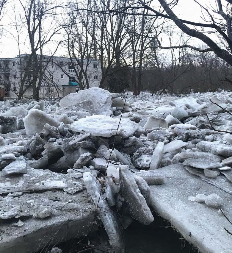
WAY
B IA
O L UM
C
CA
LE
BOLTON CORE
DO
NK
ING
FLOOD RISK MAP
TO
WN
LIN
ES
OU
TH
D
G ROA
River flooding occurs when a body of water exceeds its KIN
capacity. A river can only carry so much water within its
banks and it will fill up until it overflows, typically due to
heavy rainfall. Flooding can cause property damage and pose
T
a threat to safety, but the degree of risk varies depending on E A S
the location within the floodplain.
T
E
RE
ST
NG
• The greatest risk is to areas directly adjacent to the river. Q
AL
KI
U
EE D
BI
N A
Because the watersheds are small, short, and full of hard O
ON
ST R
RE I NG
V
landscape, rainfall will make water levels rise very quickly. ET D
K
AU
OL N
U
GH
Most watercourses in the GTA rise so quickly that sand- N
N
N
OR
VI
NRA
LL
bagging is typically not an effective protection measure.
TH
E
R
OAD
O
AD
• Properties near the outskirts of the flood plain boundary
are less likely to see riverine flooding than the lower lying
ones close to the river.
• Many crossings and culverts don’t have the capacity to pass Flood Extents Flood Vulnerable Areas
flows from a flooded river – water can back-up and pool More likely 2-year storm - 50% Institutional
to occur in a
behind these structures. given year
5-year storm - 20% Residential
Commerical/industrial
• Engineers use statistical models of different rainfall amounts Q 10-year storm - 10% Flood cluster boundary
T
U
ES
EE
25-year storm - 5% Flood-vulnerable roads
and durations, and simulate what flooding from those storms
W
N
ET
Non-real time stream gauge
ST
50-year storm - 2%
would look like through computer models. RE
R
T Real time stream gauge
ST
EE
SO 100-year storm - 1%
G
Very low
UT Precipitation gauges
N
likelihood to
KI
H occur in a
given year Regional storm < 1% Watercourse
Flow direction
City of Brampton, City of Toronto, Region of Peel, York Region, Province of Ontario, Ontario MNR, Esri Canada, Esri, HERE, Garmin, INCREMENT P, Intermap, USGS, METI/NASA, EPA, USDA, AAFC, NRCa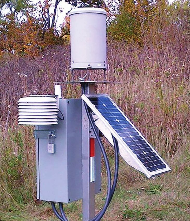
WHO SHOULD I CONTACT DURING A FLOOD IN BOLTON?

                    • If you are in danger or there is a threat to life and safety, call 911 immediately.
                    • If you see any potential damage to your property, call your insurance
                      representative as soon as possible.
                    • For power outages or to report downed wires, call Hydro One at
                      1-800-434-1235.
                    • If water rises above your electrical outlets, baseboard heaters, or furnace, or
                      is near the electrical panel, call Hydro One to have your power disconnected.
                    • To report localized flooding on municipal roads, blocked catch basins, or
                      municipal infrastructure, contact the Town of Caledon: info@caledon.ca,
                      905-584-2272 Ext. 7750.
                    • For after-hours emergencies such as downed trees on roads or flooding,
                      call the Region of Peel at 1-800-563-7881.
                    • To report river flooding, leave a voicemail on the TRCA floodline at
                      416-661-6514. A flood duty officer will return your call.
BOLTON SPA - HISTORY OF FLOODING
W CRE S
DALE ST
RD BIRCHV IE
W
GLAS GO
The Bolton SPA was established in the historic Toronto and Region Conservation Authority Special Policy Area
CE
NT
downtown area of Bolton to permit a limited BOLTON - Regional Flood Lines (Various Modelling Years)
EN
NIA
W DR
scope of development and redevelopment,
BIRCHLAWN RD
KINGSV IE
LD
R
maintain the vibrancy of the community, and
address the significant social and economic
DR
KE
FO
EY
OD RD
hardships to the community, while recognizing
NT
CRESTWO
RE
AL L
BR
HUMBERLEA RD
ST
ID
and managing the potential additional flood
GE
CR
SH E
CR
T
QUEEN ST N
risks, if no new development was permitted.
T
R IN
HICKMAN ST
CRT
VA LLE
In 2012, the Town of Caledon and TRCA
UN
DRY
Y
HE
ST
V IE W
initiated the Bolton Special Policy Area
S
PD
SACKVILLE ST
CRT
R
Update. New flood lines were created using HILLTOP CRT
modernized tools that included precision MI LL
mapping, new hydrologic data, and state-of-
S T
CHAPEL ST
the-art hydraulic modeling software. STER NE S
T
ELM S T
TEMPERANCE ST
ANN ST
DALTON ST
KING S T E
DAVID ST
This figure illustrates the historical delineation of the flood
KING ST W
JOHN ST
plain flood mapping (2013) and the existing SPA boundaries.
Generally, the extent of the flood line has not changed
NAN
W ST
WIL LO
substantially but it has been refined based on the more Flood Line (1979) SPA Boundary (Existing)
CY S
JAN E ST
detailed topographical mapping and updated hydrologic
JAMES ST
T
Flood Line (2003/04)
CONNAUGHT CRES
and hydraulic modelling of open water conditions. LOUIS A S
T ALBERT ST
Flood Line (2013)
QUEEN ST S
Ice jamming is not the basis for floodline mapping, but ice
OLD KING RD
jams may contribute to the extent of flood inundated areas. AB E TH
S T
The updated floodlines and SPA area were communicated ELI Z
NE
to the public via a public open house on April 2, 2013, July 8, CHERRY LA VICTORIA ST
2013, and March 10, 2015.
Mar 2013
2009 Ortho-photography
WHAT IS AN ICE JAM?

Long cold spells can cause the surface of rivers to freeze. When a rise
in the water level or a thaw breaks the ice into large chunks, these
chunks can become jammed at man-made and natural obstructions.
With no way past the obstruction, the river will become backed up
and can overflow its banks, causing flooding.

Ice Jams:

• Typically occur during spring thaw and rainfall
• Result from broken ice cover when pieces flow downstream
• Are very site-specific - accumulate at obstructions, bends, bridges, or
  sometimes just against other pieces of ice
• Can develop rapidly
• Multiple jams can form and release in the same place
• Can cause problems downstream if suddenly realeased as ice can
  pile up farther downstream

CAUSES OF 2019 BOLTON ICE JAM FLOOD

                                 TRCA/KGS Bolton Ice Jam Study Findings
                                 • There were two different ice-jam events in the winter of 2019.
                                 • The February 5 ice accumulation upstream of King Street subsequently
                                                  th

                                   cleared.
                                 • A second period of ice formation in upstream reaches occurred from the
                                   third week of February onwards.
                                 • Rain and warm temperatures in March caused this ice sheet upstream of
                                   Bolton to break up.
                                 • Higher flows, estimated around the 2-year event, facilitated the
                                   movement of ice downstream.
                                 • Ice jams began to form behind 181 King Street and downstream of the
                                   King Road bridge due to the shallower channel slope in this area.
                                 • Water began to back up the river toward the oxbow and overtopped in
                                   several locations including the berm at 181 King Street East.
                                 • The occurrence of ice jams is difficult to predict given the various factors
                                   (weather, river morphology, flow conditions) that contribute to ice jam
                                   formation. State-of-the-art river ice science does not provide means to
                                   predict when or where an ice jam will form.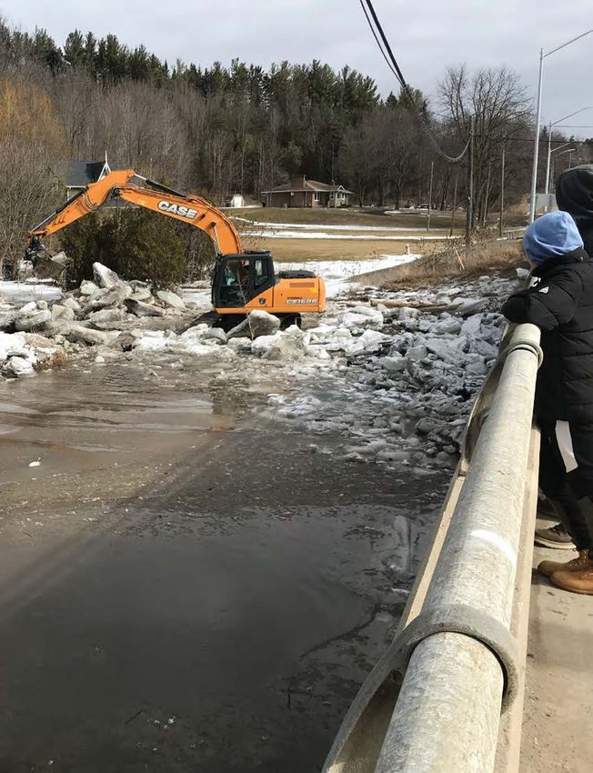
21
5
25
L
CO ITT
UR L E
T
2019 BOLTON ICE JAM MAP ¯
Q KIN
G STR E
ET E AST
ING
KIN
ROA
G
D
U D K
EE OL OAD
21
N R
0
ST
NU RO
210
250
R
EE
24
N A
21 T
5
N D
0 N
VI
O
LL
R
TH
E
24
210
21
210
0
0
Q
U
4859800
EE
SO N S
T
OLD KI U TR
ES
NG R TH E
OAD
W
T ET
E
T RE
IN GS Q
K U E
23
5 ST EE G AT
E WE SO N S EN S AR D
IV U TR E L EV
DR U
0
TH E Q OU
23
D
OO ET B
HUM C E L LW 0.5
BER O
L
LEA D ER
RO A
UR IN
D R A km
IV IN
CO ER
T
E E
220
SH
225
22
0
LEGEND
213.39
Spills
215
Berms
Crib Wall
215
Bridge
5m Index Contour (TRCA)
1m Contour (TRCA)
5
22
5
21
4859600
River Reaches
Culvert
T
EE
ST
R
A JO
ST
ETE H
Ice Jam in Channel
T
RE N
ER
S T ST
LB
NG R Flood Extent on March 16, 2019
KI EE
A
T
T
EE
R
ST
230
IA
R
TO
C
VI
5
JA
21
M
ES
ST
R NOTES:
EE
5
T
21
1. Image, Topographic Data, and High Water Marks provided by
T
21
Toronto and Region Conservation Authority (TRCA)
EE
5
R
5
ST
MI 21 2. All units are metric and in metres unless otherwise specified.
LL
OW
5
ST 23 Transverse Mercator Projection, NAD 1983, Zone 17. Elevations are
R in metres above sea level (MSL).
L
EE
IL
T
W
D
ST AV 215 215
RE ID
24
ET
0BOLTON BERM AND CHANNEL REMEDIATION STUDY
AND SPECIAL POLICY AREA UPDATE
WH
ES
IT EH
DR
CR
EAD
S
RR
RD
RE
W
TE
VIE
TC
LA
D
GS
GH
OO
In 2012 the Town of Caledon and 500-YR FLOOD DEPTH MAP (EXISTING CONDITION)
RI
N
I
SHAN G
TW
WR
KI
ES
HU
TRCA initiated the Bolton Special UNSTEADY INFLOW HYDROGRAPH (USING 1981/1983 MMM LIT
CR
MB
LAUREL PARK GATE QU E TL
R
ES
EE E
LE CR
CR
Policy Area Update to define the 500-YR FLOW = 155 CMS BASED ON FLOW N
ST FREQUENCY CURVE) A
RD
T
IEW
N
GRAY PARK DR
HV
flood risk in the Bolton core and
RC
C9
BI
confirm that the berm and channel
T R Y BLVD
were performing as per the original SHE
RIN
CR
design. Several technical studies E NGLISH R
O UN
OS E T
LA FO
NE
SC
R ES
were completed to investigate the CR
OS T CR T
C8
hydraulic, geotechnical, structural, C7 G RD
CEN JO KIN
and fluvial conditions of the berm. TEN
NIAL
DR
H N
ST OL
D
C6
New flood lines were created using
modernized tools that include E
BO
N
LA
ND
CK
ST
JA
ST
I
precision mapping, new hydrologic
ST
BR ME
RT
E
IA
R S
ST
BE
OR
HE
WA ST
AL
MI ML
CT
G
LL
KIN
data, and state-of-the-art hydraulic OC
VI
ST K
S
C1 C5 EL
modeling software. DA
T
M
T ST VI
ANS CH D
ST
M AP
HICK EL
ST
ST
SA
The Bolton Berm and Channel SA
UI
CK C4
LO
RD
VI TIM
Remediation Study and Special L OT
W
LE AN
GO
E
H
C3 ST Y
AS
ST
YL
ST
Policy Area Update concluded
GL
RR
OW
AN
T
HE
KS
ME
LL
N C
ST AD
WI
that the berm and channel system
OC
W
T
O
S
ML
ST
NE
D CR
LEGEND 500-Yr Flood Depth, m OO
HE
W
G
ER
does not provide the original level C2
N
VA
TE W
KI
EN
ST
LE
MP RT Study Area 0.00 - 0.10 L
G
C
DA ER QU
of service, which was the 500-year LT
ON
A NC
E
EE
N
ST
Bolton SPA Boundary
River Network
0.10 - 0.30
0.30 - 0.60
HE S ST ST NA
flood (0.2% chance of occurring in PD NC S Existing Flood Berm 0.60 - 0.80
DE E
R YS Existing Crib Wall 0.80 - 1.20
T
RV
VA
a given year). The berm was never Buildings 1.20 - 1.50
H ST
L LE NOTE:
AL
YV Flood Depth Mapping based on 2014 LiDAR DEM and 2015 Road Paved 1.50 - 1.80 D
L
IEW EL BE
VE
BE T
EY
Orthophoto. This mapping is intended for the sole purpose of
LL
designed to protect against ice jams. CR IZA Culvert/Bridge C1..C9 1.80 - 2.60
AIR
DR
floodplain study. Any other use of this information by a third
BE
O
T 2.60 - 3.50 DR
ZA
WL
party requires verification and is at the sole risk of that party.
TH HA DO
T
ST
ELI
NE
IN
YS
E V WN
D
SD
BL
DR
R TO N
EY
UN
R
FO NO
DRBOLTON BERM AND CHANNEL - CURRENT CONDITIONS
During the Bolton Special Policy Area Update in 2012,
TRCA reviewed the technical investigations of the Bolton
Berm and Channel to determine their conditions. The
technical findings determined the following:
1. The berm and channel don’t provide protection up to
the 500-year flood. Current protection for the berm in
some sections only passes the 100-year flood.
2. There are some minor geotechnical issues, but the berm
meets factor of safety guidelines for most conditions. Bolton Channel - flap gate, south bank Bolton Berm
3. Flap gates and culverts require maintenance.
4. There are several areas of erosion that require repair, as
does the berm around the pumphouse.
In order to fully protect against the 500-year event,
additional berms upstream of Highway 50 and downstream
of King Road would be required. These structures require
a Class Environmental Assessment and are not part of
this project.
Bolton Channel - McFall damBOLTON BERM AND CHANNEL UPGRADES
TRCA has developed several options to upgrade the TRCA is proceeding with Option 3B because it restores the original level of flood protection
berm. These include: and meets current engineering standards for stability. Option 4, while providing a higher
level of flood protection, is not practical given the property constraints of the area. The
OPTION 1: Undertake general maintenance only and construction of the proposed option is to be completed in the following phases:
maintain the berm as is with 100-year flood protection.
OPTION 2: Upgrade the berm to provide 350-year Phase 1: Phase 2: Phase 3:
protection and perform general repairs. Repair/replace flap Restore/raise the Restore/raise the
OPTION 3A: Upgrade the berm to provide 500-year gates, repair culvert flood berm west flood berm and
protection and maintain the current factor of safety end treatments of Humber Lea Rd. raise the crib wall
conditions including general repairs. and clean culverts and east of Queen east of Humber Lea
OPTION 3B: Upgrade the berm to provide 500-year (2019/2020) St. and repair the Rd. (2021/2022)
protection and to meet the current factor of safety diversion channel
guidelines. (2020/2021)
OPTION 4: Upgrade the berm to meet Regional storm
flood protection. TRCA has retained a consultant to complete final design drawings for Option 3B. TRCA is
also investigating the feasibility of raising the berm to protect against ice jams similar to
the event in March 2019. Property constraints may preclude raising the dyke to meet this
level. Additionally, there isn’t enough historical data on ice jams in this area to design for
ice jam protection.MITIGATING ICE JAMS
Options for mitigating ice jams are limited in this area
INFEASIBLE FEASIBLE
Pre-emptively breaking ice cover Ice jam removal
This option includes blasting and cutting ice before break up. This option involves using heavy equipment to mechanically
Due to the length of the Humber River and the unpredictable remove ice from the river, as was done in March 2019. This is
risks in blasting, this is not considered feasible. Blasting ice the most feasible option for ice jam mitigation in this area.
does not prevent re-formation of a jam elsewhere. Furthermore, Careful consideration is required to ensure that the movement
there are risks to property and nearby persons, as well as of jammed ice does not create or exacerbate flooding
potential damage to infrastructure including sewers and berms. conditions elsewhere. Staff should be available 24/7 to
respond when ice jams begin to form. Emergency support
Construction of ice control structures contracts should continue to be maintained with heavy
equipment contractors. An equipment access route to the
Ice control structures are similar to dams. The structures jam location can be identified and formalized.
capture and store ice upstream of areas at risk of ice jam
floods. This option is not feasible in Bolton because there Flood forecasting and warning upgrades
isn’t a suitable location upstream for this type of structure.
This is not a mitigation technique but instead provides early
River modifications warning when ice jams could be forming. Enhanced flood
warning components could include drone surveys, remote
This option includes modifications to the river to facilitate ice cameras, and additional gauges.
passage: deepening or widening the river to reduce the
possibility of ice jams. This option is also considered infeasible
in Bolton. The river is a natural watercourse and it is unlikely that
approval would be granted given the environmental impacts.TRCA FLOOD RISK MANAGEMENT
A principal mandate of TRCA is to reduce the risk to life and damage to
property caused by flooding. We do this by providing local agencies and PREVENTION & MITIGATION PREPAREDNESS
the public with notice, information and advice so that they can respond
Limiting exposure to risk: • TRCA’s flood contingency plan
during severe rainfall events that have the potential for flooding, and
• Implementing TRCA’s regulations and policies • Emergency plans
during flood related emergencies. • Emergency operations centre
Reducing risk:
• Training
• Operating a flood forecasting and warning program
• Public education
• Maintaining flood control infrastructure
• Creating a flood protection strategy for vulnerable areas
• Implementing remedial works projects Site-Specific Flood Response Plan
A Site Specific Flood Response Plan
Understanding the risks:
(SSFRP) is a tool to assist municipalities
• Climate, geology, watershed response, and potential for in responding to a flood emergency in a
climate change given flood-vulnerable neighbourhood.
It is meant to complement existing
Documenting the risks: emergency plans, such as a municipal
emergency plan or a risk-specific plan
• Floodplain mapping, identification of flood vulerable areas
for flooding.
RESPONSE RECOVERY
• Provide flood forecasting and warning • Flood event documentation and
(issuing flood messages) lessons learned
• Operate flood control infrastructure • Storm analysis
• Communicate information and advise
• Data managementREAL-TIME FLOOD MONITORING IN YOUR NEIGHBOURHOOD TRCA has a network of real-time river and rain gauges across the GTA to: • Monitor the water levels in specific streams and behind dams • Measure how much precipitation has fallen The measurements are displayed on TRCA’s Real-time Gauge flood monitoring website. While the website is primarily a tool for Flood Duty Officers to evaluate watershed conditions and assess the risk of flooding, the website is available to our municipal partners and the public: trca.ca/floodmonitoring The Station Map uses shapes, colours, and symbols to allow for a quick assessment of the conditions in the watersheds. TRCA Real-time Gauging Station Map Real-time Gauge
TRCA’S FLOOD MESSAGES

To support our municipal partners during storm events, Toronto and Region
Conservation Authority (TRCA) runs a Flood Forecasting and Warning
Program with staff on-call, 24/7. If flooding is possible or about to occur,
TRCA issues flood messages to designated individuals within municipalities,
local agencies, school boards, the media, and members of the public who
self-subscribe.

                    Sign Up for Flood Messages
                    To receive flood messages, you can either:

                    • Subscribe to email notices at trca.ca/floodmessages
                    • Follow us on Twitter at @TRCA_Flood

Flood messages are also posted on TRCA’s website at trca.ca/floodforecasting
You can also read