Data Enforced: An Exploratory Impact Analysis of Automated Speed Enforcement in the District of Columbia
←
→
Page content transcription
If your browser does not render page correctly, please read the page content below
Data Enforced: An Exploratory Impact Analysis of Automated Speed Enforcement in the District of Columbia
*accepted for publication at the 24th IEEE Intelligent Transportation Systems Conference (ITSC 2021)
Awad Abdelhalim Linda Bailey1 , Emily Dalphy1 , and Kelli Raboy2
1 2
Department of Civil and Environmental Engineering Vision Zero Initiative, ITS Program Manager
Virginia Polytechnic Institute and State University District Department of Transportation
Blacksburg, Virginia, USA Washington, District of Columbia, USA
atarig@vt.edu linda.bailey, emily.dalphy, kelli.raboy
Abstract—In 2015, the District of Columbia framed a Vision managing speeds and conflict points, and promoting safer
Zero mission and action plan, with a target of achieving zero modes of travel, such as transit, walking and cycling. However,
traffic fatalities by 2024. This study examines the impacts of challenges remain in our road safety program. Vulnerable road
Automated Speed Enforcement (ASE) and its role in achieving
the goals of Vision Zero. Independent datasets containing detailed users like pedestrians and cyclists remain over-represented in
information about traffic crashes, ASE camera locations and the District’s traffic fatalities and severe injuries, and some
citation records, and driving speeds across the District’s streets of the most at-risk populations for other types of violence
arXiv:2106.09933v1 [cs.CY] 18 Jun 2021
were collected, combined, and analyzed to identify patterns and are also suffering disproportionately from traffic deaths and
trends in crashes, speed limit violations, and speeding behavior injuries. ASE is a key pathway to achieving lower speeds and
before and after the ASE camera installation. The results of this
exploratory analysis confirm the safety benefits of ASE systems safer streets for the District. ASE is often publicly criticized
in Washington, D.C. The study also provides a blueprint for as a revenue tool for government agencies rather than a safety
the different means of evaluating the short-term impact of ASE measure. This study aims to assess the District’s ASE system
systems using different data sources which can aid practitioners both in terms of it’s impact on traffic safety as well as the rate
in better evaluating existing systems and support the decision and trends in issued citations.
making process regarding future installations.
B. Related Work
I. I NTRODUCTION
Various studies have been carried out through the years
Traffic crashes are one of the leading causes of death in
on Automated Traffic Enforcement systems, mainly red light
the World. In the United States, about 40,000 lives are lost
cameras (RLCs) and ASE systems. There has been a consensus
annually due to car crashes. In the District of Columbia, over
in the conclusions that ATEs lead to a reduction in the overall
7,000 people are involved in injury crashes every year; of
number of crashes, and a significant reduction in the severity
those crashes, over 300 result in serious, life-altering injuries,
of crashes. Some studies have concluded that RLCs may be
and in 2019, 27 have resulted in death. As the District works
associated with an increase in rear-end crashes as the drivers
to create safe streets for everyone, speed management is key.
come to abrupt stops in avoidance of citations. Other studies
Lower speeds allow drivers more time to avoid crashes, and
concluded that ASE may lead to a local reduction in speeds,
mitigate the severity of any crashes that do occur. Automated
but lead to drivers accelerating downstream of the enforcement
speed enforcement (ASE) is a critical part of reducing speeds,
site to make up the time lost driving at lower speeds.
particularly on large arterial roadways in the off-peak time
The vast majority of studies on ASE conclude that the
period, when traffic is lighter.
overall benefits overshadow the cons. Researchers have found
A. Vision Zero ASE cameras to lead to significant reductions in the frequency
The District of Columbia launched Vision Zero in 2015 to and severity of crashes in their vicinity, notably [1] , [2]
inspire and transform DC’s roadway safety efforts, and set [3]. A study by Shin et al. [4] concluded that ASE cameras
sights for a goal of zero fatalities or serious injuries on the lead to great reduction in all types of crashes but rear-end
District’s roads. Since then, DDOT has shifted to designing crashes. Cunningham et al. [5] concluded that ASEs not only
streets that are safe for everyone, however they choose to lead reduced frequency of crashes, but also positively affect
move around the city. The Vision Zero Division has developed the overall speeding behavior. Some studies have concluded
and implemented a myriad of safety projects that address the that the effect of the ASE cameras decays over time [6].
concerns of all the different groups of roadway users. Working Other researchers also propose the use of Automated Section
closely with community members to identify problems, as Speed Enforcement monitoring average speed over a closed
well as using data on past crashes, Vision Zero focuses on section as opposed to a fixed camera location and have
concluded that it produces substantial benefits [7], [8]. A
©2021 IEEE Personal use of this material is permitted. Permission from previous study evaluating automated speed enforcement in the
IEEE must be obtained for all other uses, in any current or future media, District of Columbia [9] has concluded that the system produces
including reprinting/republishing this material for advertising or promotional
purposes, creating new collective works, for resale or redistribution to servers substantial reduction in the District’s car crash frequency and
or lists, or reuse of any copyrighted component of this work in other works. in the severity of crashes.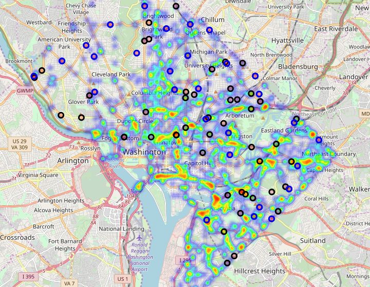
TABLE I: Data Sources Used In The Analysis
Details
Dataset Provider Information Contained Number of Records
DC Crashes PSI Traffic crashes details 92,360
Camera Locations MPD Geolocations of ASE cameras 84
Camera Citations MPD Hourly violations and citations records 72,965
Probe Vehicle INRIX Travel time and speed 1,997,410
C. Objective detailed information on the crash time and date, geo-location,
The objective of this study is to quantify the impacts of ASE severity, vehicles involved, influencing factors, alongside the
on crash frequencies, severity, and speeding behavior in select number and types of injuries.
locations within the District of Columbia, aiming to answer
Data quality issues came into question as the District’s traffic
the following questions: (1) is the ASE system beneficial to
crashes databases have experienced severe under-reporting prior
the overall traffic safety in the District, specifically in terms of
to changes in the reporting system made in August of 2015
reducing crash frequencies and severity? (2) what percentage
which have significantly enhanced the quantity and quality
of roadway users in the District are receiving citations due to
of data collected thereafter. In order to avoid data bias due
ASE? And (3) does the ASE system help in changing overall
to under-reported crashes prior to 2016, the crash data used
speeding behavior along corridors or is the speed reduction
in this analysis included only crashes that took place from
only occurring in the site of the enforcement cameras?
the beginning of 2016 until June of 2019. This has had a
II. M ETHODOLOGY significant impact on the number of study locations viable for
a before/after analysis, as the majority of the District’s 84 speed
A. Data Sources cameras have been installed prior to that. For the purpose of
To conduct the aforementioned analyses, we gathered, this analysis, 29 locations have been selected where camera
explored and analyzed multiple, independent, datasets collected installation or enforced speed limit change has taken place
by the District Department of Transportation (DDOT) and the between January of 2017 and mid-2018. This has limited the
Metropolitan Police Department (MPD) that include detailed period of comparative analysis for this study to a single year
data on traffic crashes, ASE camera locations and citations. before and after camera installation, which, albeit sub-optimal,
We also used a probe vehicle dataset collected by a third party could provide the high-level insight on the direct impact of ASE
containing the travel speeds across the District’s streets. The sought after by this exploratory study and ensures the crash data
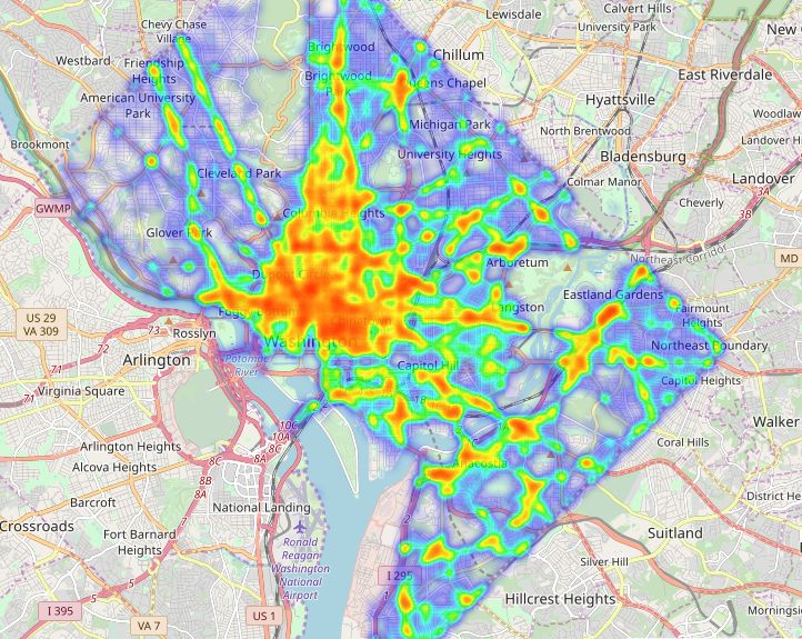
datasets used in this study and the sources they were obtained does not contain the aforementioned biases. Figure 1 shows
from are listed in table I. Crash data is available publicly the geo-spatial distribution of crashes in the District. Figure
through the OpenDC data portal based on police reports, but 1 (b) shows the crashes reported as resulting from speeding,
DDOT contracts a third party vendor, Precision Systems, Inc with the circles denoting the location of ASE cameras. The
(PSI) to further verify and clean the data. Hence, the crash blue circles denote the cameras included in the before/after
data was used from PSI’s database. The crash dataset includes analysis of this study.
(a) All car crashes in DC. (b) Crashes due to speeding.
Fig. 1: Heatmaps of traffic crashes in DC.Fig. 2: Quarterly crash counts and severity of collisions during the period of analysis (2016 to mid-2019).
Further data was obtained from MPD that includes hourly was involved. Figure 2 shows that there’s a very small number
records of passing data for all speed camera locations between of fatal crashes occurring in the District. Hence, the before and
2013 to mid-2019. The dataset includes the hourly counts of after analyses of crashes was conducted on all crashes, and
violators and non-violators, and their respective average passing then broken down to look specifically at injury and property
and violating speeds. This dataset allowed the analysis of the damage only (PDO) crashes.
trend in citations issued by the ASE cameras. Furthermore,
probe vehicle data that includes one-minute average speeds and C. Geo-spatial Clustering of Near-Camera Crashes
travel times on predefined roadway segments in the District
was obtained from INRIX, this was used for the analysis trends In order to identify the crashes taking place in the vicinity
and patterns in speeds along roadway segments prior to and of cameras, the distance from the location of each crash to the
post ASE camera installation in order to quantify and visualize location of the 29 selected locations of interest was calculated,
the impact (if any) that those cameras have on drivers behavior using haversine distance shown in equation 1.
within those roadway segments.
v
!
u
u
B. Data Pre-Processing and Exploration d = 2r ∗ arcsin tsin2
u φ2 −φ1
2
+cos(φ1 )cos(φ2 )sin2
λ2 −λ1
2
All dataset pre-processing, cleaning, and aggregation was (1)
carried out in SQL. During the period of interest between Where φ , φ , λ , λ are respectively the latitude and longitude
1 2 1 2
January of 2016 - June 2019, a total of 92,360 crashes have coordinates for the given car crash and the coordinates of ASE
taken place within the District of Columbia. Figure 2 shows cameras locations.
the quarterly breakdown and severity of the crashes. Crashes were then deemed to belong within the vicinity of
The geo-spatial mapping of crashes and speed camera a specific speed camera location if they fall within the area of
locations shown in figure 1 indicated that the majority of influence associated with that camera. In order to determine the
crashes that are reported as speed-related occur in locations area of influence for the speed cameras, a maximum distance
with no speed camera installed. The speed camera location of 750 feet was assumed. For locations where the distance
are indicated by circles, where the blue circles indicate the to the nearest adjacent intersection was greater than 750 feet,
camera locations of interest in the study. It is worth noting that this maximum distance was used. In locations with adjacent
only 2% of crashes (∼ 1,800 crashes) were reported as crashes traffic signals, the distance was decreased in order reduce the
where speeding was the causing factor. Such attribute is most upstream influence of traffic signals operations on travel speeds.
likely under-reported, since the police officers who produce For example, the camera located on the 3100 block of Alabama
the crash reports arrive on-site after the crash has taken place, Ave NE (facing northeast-bound travel) is influenced by the
and would most likely report the crash as a result of speeding upstream signal at the intersection of 32nd Street & Alabama
only if sufficient evidence exist (in terms of damage). Due to Ave SE. Thus, the area of influence was reduced to 400 feet.
the speeds of the majority of streets in the District being at
or below 30 miles per hour, this is typically under-reported. (
Furthermore, crashes resulting from Driving Under Influence argmin(d), if min(d) ≤ range
Camera assignment = (2)
(DUI) are not reported as speeding crashes, even if speeding None, otherwiseSince haversine distance is blind to topography and street TABLE III: Descriptive Statistics For The Total Before and
layout, crashes deemed to fall in the vicinity of each camera After Crash Counts For The 29 ASE Camera Locations
location were further queried using street identifiers (an attribute
in the crashes dataset) and the travel directions of vehicles All Crashes PDO Crashes Injury Crashes
involved in a crash, such that crashes are only assigned to an Before After Before After Before After
ASE camera location should they fall within the specified range
from the speed camera, and at least one of the vehicles involved min 0.00 0.00 0.00 0.00 0.00 0.00
is traveling on the same street and in the same direction that
25% 1.00 0.00 0.25 0.00 0.00 0.00
the camera is enforcing the speed limit. This was to ensure that
crashes that may have minor location accuracy errors and have 50% 2.00 2.00 2.00 1.00 1.00 0.00
occurred on crossing or nearby streets are not mistakenly taken
75% 4.00 5.00 3.75 3.00 2.00 2.00
into account. As previously mentioned, the ASE locations for
the before and after crash assessment were selected on the basis 90% 9.60 7.40 7.50 6.00 4.20 2.00
of data availability from 2016 onward. Hence, all locations
max 21.00 12.00 17.00 9.00 5.00 4.00
have at least one year of crash data before and after installation.
mean 3.74 3.10 2.92 2.15 1.36 0.96
III. R ESULTS
std 4.94 3.32 3.93 2.63 1.60 1.20
We present the results of our analyses in terms of three
different key points of interest: TABLE IV: District-wise Year-to-Year Changes
(A) Before and After Crash Counts
Crash Type 2016-2017 2017-2018
(B) Speed Limit Violations and Citation Rates
(C) Changes in Speeding Behavior All 0.05% 0.67%
PDO Crashes -1.67% 1.07%
A. Before and After Crash Counts Comparison at Speed
Injury Crashes 5.49% -0.46%
Camera Locations
The analysis of the before and after crash statistics at the
selected camera locations shows a downtrend in all crash types. B. Speed Limit Violations and Citations
For all the 29 locations, the average year-to-year reduction
Automated speed enforcement systems have always been a
in crashes in the vicinity of the cameras was 9.35%, 13.16%,
subject of public scrutiny due to the fear of unfair citations.
and 30.30% respectively for all crashes, property damage only
To assess this, we analyzed citation data obtained from the
(PDO), and injury crashes as shown in Table II. Table III shows
Washington D.C MPD to evaluate citation trends for the
the descriptive statistics of the before and after crash counts
selected subset of speed enforcement cameras. To account for
tallied for each of the 29 ASE camera locations. Significant
changing volumes, we looked at citations as a percentage of
reductions can be seen in average and maximum crashes near
passing traffic. For the 29 locations of study, the average citation
ASE camera sites after installation. The reduction in standard
percentage starts at 1.18% in the first month of installation,
deviation of crash frequencies after installation also indicates
steadily decaying to 0.79% after 12 months as illustrated in
that the reduction of crashes occurs across all sites.
Figure 3.
TABLE II: Before/After Crash Analysis
Aggregate Totals
Crash Type Before After % Change
All 107 97 -9.35%
PDO Crashes 76 66 -13.16%
Injury Crashes 33 23 -30.30%
Comparing the results above to the overall year-to-year
changes throughout the District showcases the positive safety
impact of the automated speed enforcement system. The year-to-
year changes across the different crash types doesn’t follow any
trend and seems almost stagnant, aside from a 5.5% increase
in injury crashes between 2016 and 2017, shown in Table IV.
It is worth noting that those annual statistics do not take into
account any changes in traffic volume. Fig. 3: Average percentage of citations over time.We contrast this to three locations with the highest historic segment broken down by different percentiles. Figure 5 shows
citation rates in the District. The three locations were not a the hourly distribution of those speeds before and after ASE.
part of the 29 sites used for the crash frequency assessment as
they have been installed prior to the period of interest in this TABLE V: DC 295 Location Speed Statistics
study. The same trend of decaying citation percentage over
Measure Before Enforcement After Enforcement
time was noticed as shown in Figure 4, going down to as low
as 0.5% three years after installation. Mean 53.01 50.51
Standard Deviation 6.62 4.88
25th Percentile 50 49
50th Percentile 53 51
75th Percentile 56 53
95th Percentile 63 57
99th Percentile 72 61
ASE cameras in the District issue citations after a passing
vehicle exceeds the speed limit by more than 11 mph. The
camera on this specific site is enforcing a 50 mph speed limit,
Fig. 4: Percentage of citations at high-citation locations.
hence issuing citations for vehicles whose speed exceeds 61
C. Speeding Behavior mph. Looking at the speed data before installation, the top 5%
To further assess the if the decaying citation rate and of the passing vehicles would have been issued citations if
reduced crash frequency were a result of changes in speeding they all do not comply. The site had a 2.2% citation rate in
behavior along the roadway segment and not just at the site of the first month after installation, meaning well over 50% of
enforcement, we used probe vehicle data to analyze the change those who were previously speeding have complied directly
in driving speed in the corridor of an ASE camera. The data upon enforcement. The speed data also shows that a year after
used contains high granularity speed data (up to one-minute enforcement, 99% of the drivers were driving at or below the
average) across roadway segments. We used the speed data threshold for citations, which conforms with the citation rate
for route which contains the site on DC 295 (also known as falling below 1% after the first year of installation as obtained
the Anacostia Freeway), for which the citations were shown from the citation data and illustrated in Figure 4. A year after
in Figure 4. Table V shows the year-to-year changes (a year enforcement, the average speed on site is equal to the desired
prior to installation, and a year after) of speeds in that roadway and enforced speed limit of 50 mph. The before and after
probability distribution of speeds is illustrated in Figure 6.
Fig. 5: Speed distribution of vehicles in the DC 295 location.from 1.18 percent of all passing drivers to 0.79 percent over
the first twelve months after camera activation. Finally, a third
analysis evaluates the distribution of speeds at a high-volume
ASE site along DC 295 before and after enforcement. While
mean speeds declined by less than 3 mph, the most aggressive,
fastest drivers in the top 1 percentile reduced their speeds by
over 10 mph, from 72 to 61 mph, in response to the presence
of the ASE.
The outcomes of this analysis will be used to guide the
selection of new installation sites for speed cameras and using
the available data in developing performance measures to
actively evaluate the impacts of current and future locations.
Limitations in data continuity over time, due to the dramatic
improvements in crash data reporting in the District since
Fig. 6: KDE of speed in the vicinity of DC 295 location. 2016, and the biased traffic patterns in 2020 due to the
To reduce errors in speed over-estimation, the speed data ongoing pandemic, impinged on the ability of the study to
provider caps the estimated speeds in the vicinity of the site cover multi-year periods before and after installation. Future
at 75 mph, hence a bias can be noticed in the probability studies should use the new baseline set through this analysis
estimate of 75 mph. The probability distribution of speeds to review the effect of ASE on crashes over longer periods of
shows the significant shift in speed distribution towards the time. Identifying and comparing ASE sites to similar sites or
desired 50 mph limit, accompanied by a significant reduction in corridors with no ASE presence for a more rigorous statistical
speeds above that limit. Similar behavioral shifts were observed assessment is also strongly recommended by the authors. Future
only 3 months after installation. Those results provide an research should continue to assess the association between
insight to practitioners for estimating the citations rate using traffic speeds at various percentiles and the likelihood of crashes
the existing speed data at a given site before enforcing a speed occurring on roadways. Crash analysis methodologies typically
limit. Gradually decreasing the enforced speed as the behavior require multiple years to lapse before any assessment can
change occurs may provide the desired safety benefits while be made on an intervention’s safety impact, whereas speed
aiding in reducing public skepticism towards ASE. data can be captured and analyzed almost immediately after
interventions are conducted given modern data availability.
IV. D ISCUSSION AND C ONCLUSION
V. ACKNOWLEDGEMENT
In this study, we quantified impacts of ASE on crash
frequencies, citations, and speeding behavior in select locations This study was supported by the Howard University Trans-
within the District of Columbia using traffic crash, ASE portation Research Center. The authors thank HUTRC for their
citations, and probe vehicle trajectory datasets collected within support.
R EFERENCES
the District’s streets. The results of this exploratory analysis
[1] C. Wilson, C. Willis, J. K. Hendrikz, R. Le Brocque, and N. Bellamy,
confirm that automated speed enforcement provides an evident “Speed cameras for the prevention of road traffic injuries and deaths,”
contribution to increasing safety and achieving the District’s Cochrane database of systematic reviews, no. 11, 2010.
Vision Zero goals. This exploratory analysis used several [2] T. S. Committee et al., “Towards zero deaths: National strategy on
highway safety,” FHWA, Undated.[Online]. Available: http://www. to-
distinct methods to understand the influence of automated wardzerodeaths. org/home. php.[Accessed 3 Novemeber 2014], 2014.
enforcement on driver behavior, in particular on the proclivity [3] E. De Pauw, S. Daniels, T. Brijs, E. Hermans, and G. Wets, “An evaluation
of drivers to speed, which has been identified as a critical of the traffic safety effect of fixed speed cameras,” Safety science, vol. 62,
pp. 168–174, 2014.
factor for reducing the number and severity of traffic crashes. [4] K. Shin, S. P. Washington, and I. van Schalkwyk, “Evaluation of the
By analyzing the pre and post-installation crash patterns near scottsdale loop 101 automated speed enforcement demonstration program,”
29 traffic cameras, the study shows a clear reduction in overall Accident Analysis & Prevention, vol. 41, no. 3, pp. 393–403, 2009.
[5] C. M. Cunningham, J. E. Hummer, and J.-P. Moon, “Analysis of automated
reported crashes in comparison to the District’s overall trends. speed enforcement cameras in charlotte, north carolina,” Transportation
In addition, injury crashes – which include the most severe Research Record, vol. 2078, no. 1, pp. 127–134, 2008.
and life-altering crashes on District roads – are reduced even [6] L. Carnis and E. Blais, “An assessment of the safety effects of the french
speed camera program,” Accident Analysis & Prevention, vol. 51, pp. 301–
more than less serious crashes. 309, 2013.
A key second analysis conducted through this study is [7] A. Montella, B. Persaud, M. D’Apuzzo, and L. L. Imbriani, “Safety
the citation rate over time, meaning the percentage of all evaluation of automated section speed enforcement system,” Transportation
research record, vol. 2281, no. 1, pp. 16–25, 2012.
drivers passing an ASE camera that receive citations. Data [8] D. W. Soole, B. C. Watson, and J. J. Fleiter, “Effects of average speed
from multiple cameras on high-volume roadways shows a clear enforcement on speed compliance and crashes: A review of the literature,”
pattern of decaying citation rates over time, as frequent flyers Accident Analysis & Prevention, vol. 54, pp. 46–56, 2013.
[9] J. Rogers, S. Dey, R. Retting, R. Jain, X. Liang, and N. Askarzadeh,
reduce their speeds to stay within the non-citation range for “Using automated enforcement data to achieve vision zero goals: A case
the ASE program. This matches the pattern identified in the 29 study,” in 2016 IEEE International Conference on Big Data (Big Data),
cameras studied for crash analysis, where citation rates decayed pp. 4029–4031, IEEE, 2016.You can also read


