Current Status and Future Plan of JAXA Earth Observation Missions for Climate Studies and Operational Applications
←
→
Page content transcription
If your browser does not render page correctly, please read the page content below
Current Status and Future Plan of
JAXA Earth Observation Missions
     for Climate Studies and
    Operational Applications

M. Kachi, H. Murakami, T. Kubota, A. Kuze,
     T. Tadono, R. Oki & T. Nakajima
 Japan Aerospace Exploration Agency (JAXA)

 with supports from M. Yamaji, M. Yoshida and JMA
                                        AOMSUC-10@Melbourne, Australia
                                                       4-6 Dec. 2019
Japanese Earth Observation Satellites
                                                                                 Work plan of Space Policy Committee, Cabinet Office
Targets (JFY: Apr-Mar)               2012     2013         2014     2015       2016 2017 2018 2019 2020 2021 2022 2023
Disasters & Resources                                    [Land and disaster monitoring]
JERS1/OPS, SAR (1992-1998)                                                  ALOS-2 / PALSAR-2                                         ALOS-4/Advanced SAR
ADEOS-I/AVNIR
ALOS/AVNIR2, PALSAR (2006-2011)                            ALOS-2CIRC
                                                                  ISS/CIRC                                                         ALOS-3/Advanced Optical

Climate System                           TRMM / PR 1997~              [Precipitation 3D structure]                                                                            [Wind, SST ,
•Water Cycle                       with NASA
                                                                    GPM / DPR                                              Feasibility study                                  water vapor,
ADEOS-II/AMSR (2003)                                                                                                                                                          precipitation]
                                                      with NASA
Aqua/AMSR-E (2002-2011)                                                                                                                        AMSR-2
                                                                                                                                               Successor Sensor

                                                       [Wind, SST , water vapor, rainfall]                                                                        TANSO-2      GOSAT-GW/
                                                                                                                                                                  Successor

                                                     GCOM-W / AMSR2
                                                                                                                                                                  Sensor

                                                                                                                                                                                AMSR3

•Climate change                                                                        [Vegetation, aerosol, cloud, SST, ocean color]
ADEOS-I/OCTS (1996-1997)                                                                                         GCOM-C / SGLI
ADEOS-II/GLI (2003)                                                                                                             [Cloud and aerosol 3D structure]
                                                                                                                                            EarthCARE / CPR
                                                                                                                                       with ESA
                                            [CO2, CH4]
                                  GOSAT / FTS, CAI 2009~                                                                                                                        GOAT-GW/
•Greenhouse gases                   with MOE
                                                                                                                                                                                 TANSO-3
                                                                                                          [CO2, CH4, CO]
                                                                                               with MOE                            GOSAT-2

JMA geostationary                       MTSAT-1R (Himawari-6)
                                                                                                                                        Himawari 10/11 planning
meteorological                                MTSAT-2 (Himawari-7)                           [Cloud, aerosol, SST]
satellites                          [Cloud, SST]                                                 Himawari-8/AHI
                                                                                                               Himawari-9 (standby)

 Mission status                                                                                                                                                                           2
                           Completed            On orbit             Development                     Pre-phase-A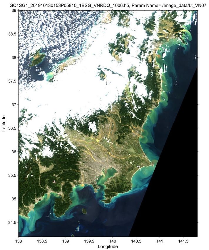
Launch of Greenhouse gases Observing
SATellite-2 (GOSAT-2)
                                GOSAT-2 launch on Oct. 29, 2018                              TANSO-FTS-2 first spectra
                                                                                            Dec. 13, 2018, Nagoya, Japan
                                TANSO-FTS-2
                                (1)Adding Carbon Monoxide (CO)                                                O2

                                   measurement to identify CO2
                                   enhancement by combustion
                                (2)Wider pointing angles
                                (3)Fully customized observation pattern                                CH4               CO2

                                (4)Cloud avoiding pointing

GOSAT-2 CAI-2-forward   GOSAT-2 CAI-2-Backward                        TANSO-CAI-2                CO
                                                                                                        CH4              CO2

                                                                      (1) 10 bands
                                                 Iran                 (2) Multi-viewing
                                                 Duba
                                                         Pakistan
                                                                      capability improved
                                                 i
                                                                      aerosol detection
  GOSAT CAI Nadir                                       Arabian Sea                              CO2               CH4
                        TANSO-CAI-2
                        first light
                        (Nov. 5, 2018)
                                                                                                       Dec. 13, Nagoya

                                                                                                                               3
Data Release of Global Change Observation
Mission – Climate (GCOM-C) in Dec. 2018
  Water-cloud                 Aerosol
 optical thickness        optical thickness     Leaf area index               PAR        Chlorophyll-a conc.

                                                                                                               ◀ GCOM-C provides
  Water-cloud                                                             Land surface
 effective radius        Snow grain size       Above ground biomass       temperature           SST            29 data products
                                                                                                               from G-Portal

                     Sea Surface Temperature                      Chlorophyll-a

                                                                                                      ◀ SGLI on GCOM-C has
                                                                                                      250-m resolution and
                                                                                                      captured fine structures of
                                                                                                      ocean current and eddies.

     2019/05/08
                                                                                                                               44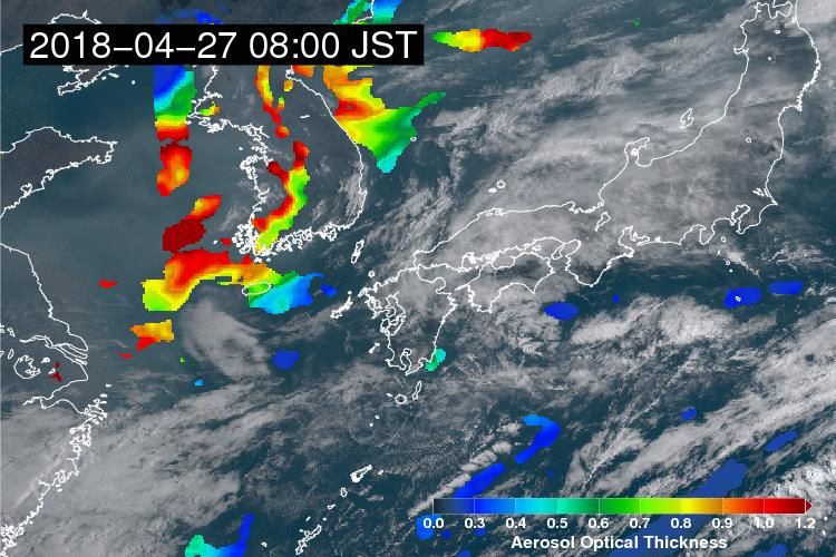
GOSAT-GW & AMSR3
Global Observation SATellite for GHG and Water Cycle
The GOSAT-GW satellite will carry two missions, AMSR3 and
TANSO-3.
◼ AMSR3, led by JAXA, will succeed AMSR series observations with new
high-frequency channels (166 & 183 GHz) for solid precipitation
retrievals and water vapor analysis in numerical weather prediction.
◼ TANSO-3, led by Japanese Ministry of Environment (MOE), will improve
observation capability of greenhouse gases from GOSAT-2/TANSO-2.
◼ Internal project approval review was completed in Nov. 2019, and
became official project in Dec. 2019. AMSR-2
Orbit Specification Successor Sensor
◼ 666 km altitude (same as GOSAT) and
13:30 LT in Ascending node (same as GCOM-W)
TANSO-2
Successor
Sensor
Mission Targets of AMSR3
◼ Understanding water cycle variation and impacts of climate change
◼ Improvements in numerical weather prediction, typhoon analysis, etc.
◼ Contributions to fisheries near coast
◼ Contribution to navigation support in polar oceans
5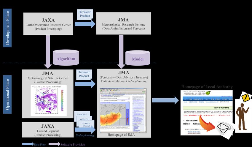
Example of Collaborations (1):
Aerosol Monitoring and Forecasts

                                             Jeju Island (altitude:1950m)
                                             (blocks the aerosol)

• The high and nearly continuous AOT over land
  and ocean are estimated from Himawari-8/AHI
• Transports of aerosols are captured by utilizing
  frequent (10-min) observations by AHI
                                                                            6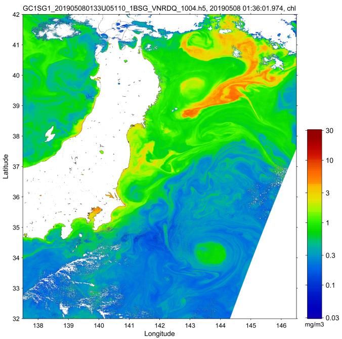
JMA-JAXA Collaboration Framework
for Aerosol Forecasts
                 Data assimilation
                                     • JAXA has provided the Himawari
                  (MASINGAR)
                                       aerosol algorithm (L2, L3) to JMA, and
                             MRI       JMA has implemented the algorithm to
                                       its operational system.
                                     • JMA plans to start data assimilation of
                                       the Himawari aerosol in its
                                       operational system in January
                                       2020.
                                     • Data assimilation of aerosol by polar
                                       orbital satellites (e.g. GCOM-C/SGLI)
                                       will be the next target.

                                                                                 7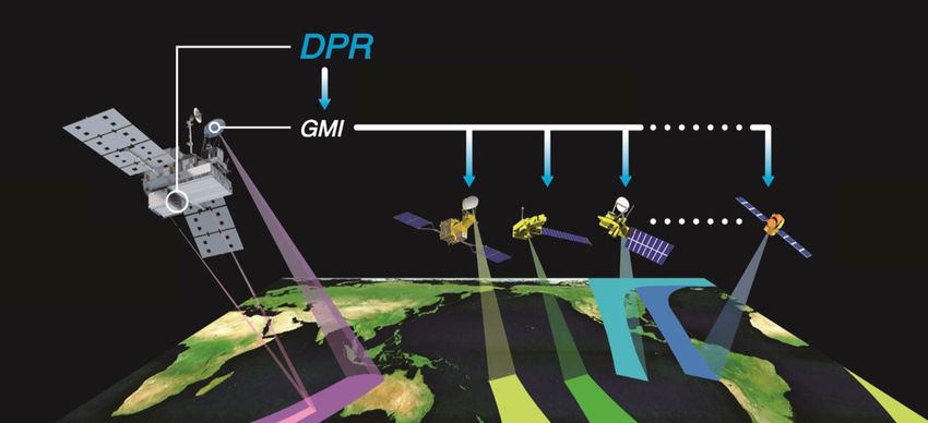
Example of Collaborations (2):
Global Satellite Mapping of Precipitation
                         Dual-Frequency
                                                         Gauge-adjusted
                         Precipitation                                    Quoted by JMA website

                         Radar       Providing reference standard
                                     GPM
                                  Microwave                                                                              cloud motion
                                   Imager
      Global                                                                                                           information by IR
      Precipitation                                                                                                        imager on
      Measurement                                                                                                    Geostationary satellite
      Core satellite                           Constellation satellites                                       ©JMA

                  Precipitation                 Microwave
                                                                                                  IR Imager
                     Radar                      Radiometer

 • hourly global rainfall data       Multi-satellite       Rainfall Product
 • 0.1x0.1deg. lat/lon                                                                             distribution
 • Various version such as realtime for
   monitoring or long-term gauge-                                                                  ・website ・CSV
   adjusted for climatological                                                                     ・netCDF ・Binary
   purposes                                                                                        ・GeoTIFF ・png
                                                                                                                                       8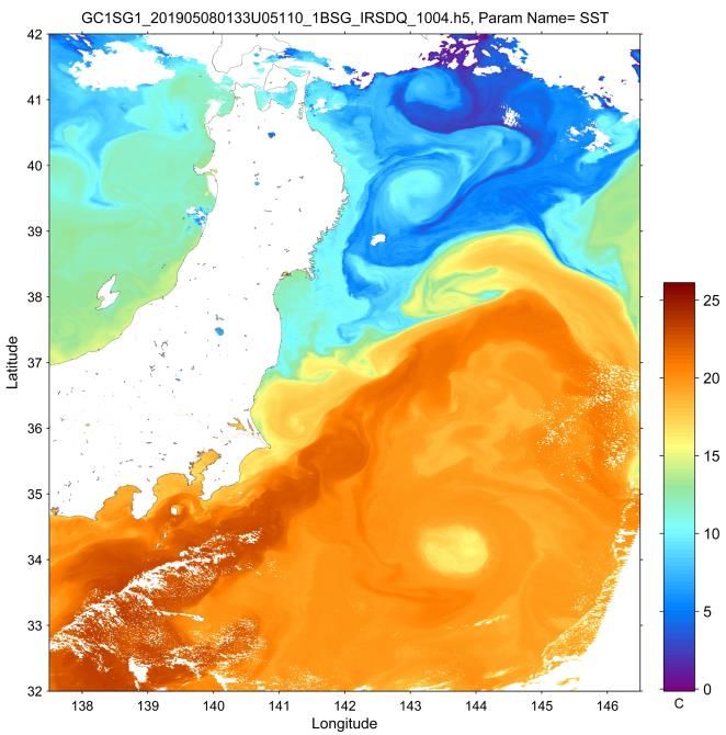
アフリカ, 100 , 4%                                           不明, 2, 0%

Utilization of GSMaP in Asia-Oceania
      ヨーロッパ, 177 , 7%

In Asian region,                                                                                                                                           In Oceania region,
                                           オセアニア, 79 , 2%
                          アフリカ, 148 , 4%               不明, 2, 0%

        Oceania 2%
                ヨーロッパ, 270 , 6%
                                               オセアニア, 41 , 2%
                                                                                                                                                          1000                          Increasing     Timeseries of
                                                                                         5380
                          アフリカ, 100 , 4%                     不明, 2, 0%

      Africa北米・中南米,
             3%
         北米・中南米,
                    256 , 10%
                 398 , 9% 177 , 7%
                                                                                         日本, 856 , 34%registered (data analysis) users from
                                                                                                                                                           800
                                                                                                                                                                       FIJI           during Cyclone
                                                                                                                                                                                                       PageView from
             ヨーロッパ,

                             Japan                                                                                                                                         TONGA         seasons
   Europe 7%
 Americas 9%                  32%
                           北米・中南米, 256 , 10%
                                                              日本, 1373 , 33%
                                                                                                   128 countries as of Oct.2019.                           600                                         Pacific Islands
                                                                                                                                                           400
                                                                      日本, 856 , 34%

                                 Asia
                                 アジア(海外)(中東含む),
                                                                                               79% of total registered users are                           200
           (including Middle East)   1915 , 46%
                                     アジア(海外)(中東含む),
                                         1083 , 43%                                                originally from      Asian region.                        0
                                                                                                                                                                               SOLOMON
                     47%
                    アジア(海外)(中東含む),
                                                1083 , 43%
                                                                                                                                                                   Users from Pacific islands use
           日本      アジア(海外)(中東含む)              北米・中南米        ヨーロッパ        アフリカ     オセアニア     不明

                Various application fields using GSMaP in Asia
           日本       アジア(海外)(中東含む)                 北米・中南米           ヨーロッパ          アフリカ     オセアニア   不明

                                                                                                                                                                      website for monitoring
 Operational                                                                    Disaster Report                          Agricultural                                                    Himawari
 Weather Monitoring                                                                                                      Climate Monitoring                                        Higher-resolution Cloud

 日本      アジア(海外)(中東含む)                                      北米・中南米                    ヨーロッパ        アフリカ     オセアニア       不明

                                                                                                          GSMaP

@BMKG, Indonesia                                                               @Disaster                                                                         @Solomon
Officers monitoring rainfall                                                   Management
                                                                                                                             Drought Anomaly                     met service
using GSMaP                                                                    Centre, SriLanka
                                                                                                                             in Thailand
                                                                               https://reliefweb.int/sites/reliefweb.                                                                         GSMaP
                                                                                                                             https://suzaku.eorc.jaxa.j
                                                                               int/files/resources/Situation_16_M
                                                                                                                             p/JASMIN/index.html                                    Directly observed Rainfall     9
                                                                               ay_2016.pdf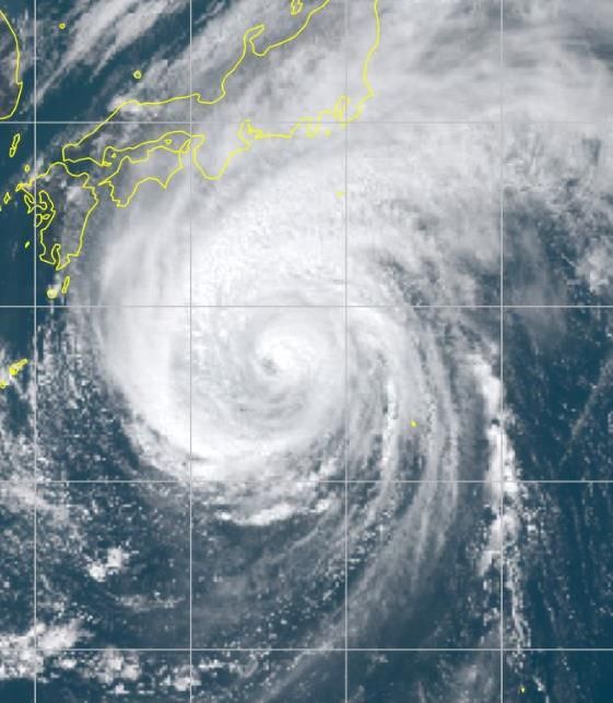
JAXA & JMA’s Collaboration in Technical
Development toward the Utilization of GSMaP
 WMO’s Regional Specialized Meteorological Centre Tokyo for
Nowcasting (RSMC Tokyo for Nowcasting) operated by JMA supplies
National Meteorological and Hydrological Services (NMHSs) with graphical
nowcasting products to help improve capacity for disaster risk reduction.
 JAXA and JMA started collaboration toward the utilization of GSMaP
data in the issuance of warnings by NMHSs in Asia and Pacific region
through the RSMC Tokyo for Nowcasting.

                                           Phase II (2020-2022)
                                                 Development of integrated regional
                                              QPE (Quantitative Precipitation Estimation)
 Phase I (2018-2019)                         and QPF (Quantitative Precipitation Forecast)

       Evaluation of uncertainties
  in rainfall analysis and prediction in
               GSMaP data

                                                                                             10
GSMaP’s Contribution to WMO SEMDP
Space-based Weather and Climate Extremes Monitoring Demo. Project
WMO Space-based Weather and Climate Extremes Monitoring (SWCEM) Demonstration Project
(SEMDP), East Asia and Western Pacific Regional Subproject initiated in 2018 (Kuleshov et al.
2019, DOI:10.5772/intechopen.85824).
JAXA participates to this subproject with the GSMaP, and provide the GSMaP_Gauge_NRT
product with 19yr-climate normal.
Targets are heavy rainfall and drought from 5-days up to a month.
WMO SEMDP Case study over Indonesia on Dec2014
Kinck-off Workshop, Reporting gauges
Satellite Detected Region of Extreme
Jan. 2018, BMKG, Heavy Rainfall based upon percentiles
Jakarta, Indonesia from past 19-yr data
GSMaP (v6) Gauge-NRT
WMO SEMDP
Workshop,
Nov. 2018, Kuala
Lumpur, Malaysia
(mm/day)
11Example of Collaborations (3):
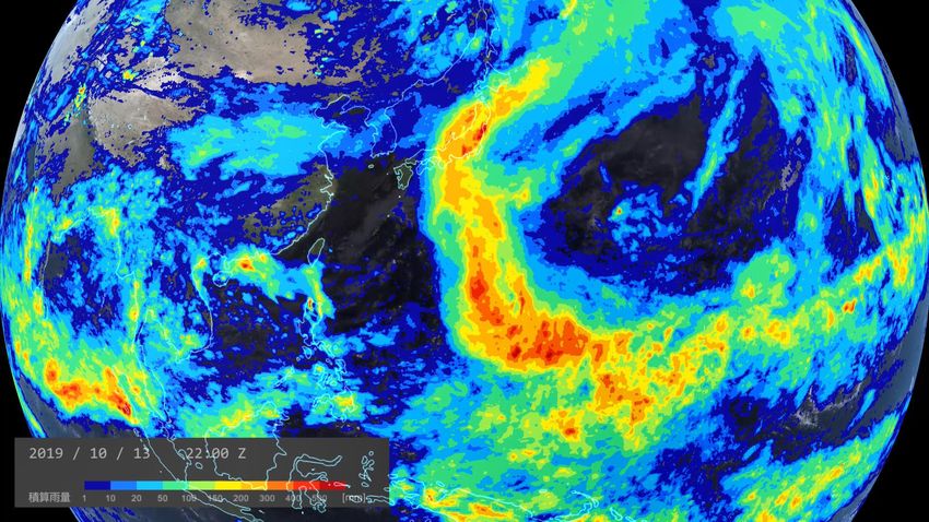
Multi-satellites and Models
Hourly animation of GSMaP accumulated
rainfall by the Super Typhoon No.19 “HAGIBIS”
from 00Z 5th Oct. to 23Z 13th Oct., 2019 12
12Inside Structure of the Super Typhoon No.19
“HAGIBIS” in Oct. 2019 by GCOM-W
Himawari-8/AHI VIS GCOM-W/AMSR2 Rainfall GCOM-W/AMSR2 TPW
3:50-59Z on 11 Oct. 2019
• AMSR2 can capture structure of
rainfall, total precipitable water and GCOM-W/AMSR2 All-Weather
wind speed under the typhoon clouds Sea Surface Wind Speed
13Capturing the Damages Caused by
the Typhoon by ALOS-2 and GCOM-C
Flooding
Simulation of river discharge by area
1-kmaround Chikuma
resolution land river detected by ALOS-2/PALSAR Sediment discharges/suspended solids along the coast
surface/floodplain modelat (Today’s
2:56Z onEarth
13 Oct. 2019.
- Japan) detected by GCOM-C/SGLI at 1:53Z on 13 Oct. 2019.
Flooding of Chikuma river was forecasted by the
model. 3m res., HH pol.
Flooding
area
Broken
bank
250m res.,
RGB composite
https://www.eorc.jaxa.jp/water/
14JAXA’s Open and Free EO Data and Services
Portal Name and URL
G-Portal
Provides products of GPM, GCOM-W, GCOM-C, GOSAT, and Past Satellites and Sensors (MOS-1/1b, JERS-1,
ADEOS, ADEOS-II, Aqua/AMSR-E, TRMM/PR) https://gportal.jaxa.jp/gpr/
(Contacts : z-gportal-support@ml.jaxa.jp)
GSMaP: Global Satellite Mapping of Precipitation
Provides hourly Global Rainfall Map in Near-Real-Time (GSMaP_NRT), available four hours after observation.
(GPM-Core GMI, TRMM TMI, GCOM-W1 AMSR2, DMSP series SSMIS, NOAA series AMSU, MetOp series AMSU,
and Geostationary IR)
https://sharaku.eorc.jaxa.jp/GSMaP/
(Contacts : z-trmm_real@ml.jaxa.jp)
JAXA Himawari Monitor
Provides multi-satellite products from the Himawari Standard Data provided by the Japan Meteorological Agency
(JMA) as well as the geophysical parameter data (Aerosol Optical Thickness, Sea Surface Temperature, Short
Wave Radiation, Chlorophyll-a, Wild Fire, Photovoltaic Power, Cloud Optical Thickness and Cloud Type) produced
by JAXA.
https://www.eorc.jaxa.jp/ptree/
(Contacts : z-ptree@ml.jaxa.jp)
GDAS: GOSAT Data Archive Service
(Operated by National Institute for Environmental Studies (NIES))
Provides GOSAT products (Methane and CO2).
https://data2.gosat.nies.go.jp/index_en.html
(Contacts: gosat-support@nies.go.jp)
15You can also read