Commencing at 5.00pm Wednesday, 26th of May 2021 - ADMINISTRATION CENTRE EATON Shire of Dardanup
←
→
Page content transcription
If your browser does not render page correctly, please read the page content below
To Be Held

Wednesday, 26 th of May 2021
  Commencing at 5.00pm
               At

        Shire of Dardanup
  ADMINISTRATION CENTRE EATON
     1 Council Drive - EATON

                    This document is available in alternative formats such as:
                                                               ~ Large Print
                                    ~ Electronic Format [disk or emailed]
                                                                Upon request.
(Appendix ORD: 12.3.1A)
Nathan Ryder

From:                               Luke Botica
Sent:                               Tuesday, 20 April 2021 6:13 PM
To:                                 Nathan Ryder
Subject:                            Fwd: Eaton Drive Proposed Intersection Treatments
Attachments:                        image001.jpg; image002.jpg; image003.jpg; image004.jpg; image005.png;
                                    image001.jpg; image002.jpg; image003.jpg; image004.jpg; eaton-dr-council-ave-
                                    roundabout-lou-v8-A1 1-500.pdf

Hi Nathan

See attached and below.

Regards
Luke

Luke Botica
Director Infrastructure
Shire of Dardanup

Begin forwarded message:

          From: "PALANDRI Lou (PMD)"
          Date: 20 April 2021 at 10:28:42 am AWST
          To: Luke Botica
          Cc: "COPPEN Matthew (PMD/A)"
          Subject: Eaton Drive Proposed Intersection Treatments

          Luke,

          Attached concept plan shows the alternative spiral treatment. Will obviously be subject to more
          detailed design if you decide to proceed with implementation.

          Pedestrian crossing between Hands Avenue and new Council Drive would have to be configured as a
          staggered crossing similar to what is shown on the plan. Pedestrians would have to activate the
          signals separately for crossing of each carriageway. Again, all this would have to go through a Main
          Roads approval process which would include an assessment of the location and need for a signalised
          crossing.

          Can’t see how signals at the new Council Drive intersection could be accommodated. Main issue is
          that it would be difficult to provide a right turn lane long enough on Eaton Drive to avoid the
          problem of right turning vehicles spilling into the through lane. Can also see some other potential
          issues, but you could investigate this further to absolutely prove the point.

          Happy to discuss.

          Regards

          Lou

                                                           1
(Appendix ORD: 12.3.1A)
From: Luke Botica
Sent: Monday, 19 April 2021 4:38 PM
To: PALANDRI Lou (PMD)
Cc: Nathan Ryder
Subject: RE: CM: Eaton Drive Proposed Intersection Treatments

CAUTION: This email originated from outside of Main Roads. Do not click links or open attachments unless you
recognise the sender and know the content is safe.

Hi Lou

Thanks for your feedback and help on this matter.

The spiral option is our preference if the roundabout has to stay. It would be great if you could
provide a sketch of it if it is not too much trouble.

With regards to the roundabout staying, would it be possible to include a signalised pedestrian
crossing for the pedestrian crossing shown on Eaton Drive between Hands Avenue and the future
Council Drive intersections? Could these signals be combined with the future Council Drive
intersection, thus enabling further manoeuvres at this intersection? Do you have any feedback
regarding this idea, as I am expecting this question from the Shire’s Councillors and probably the
community as well when we start consulting with them?

Thanks
Luke

Luke Botica
Director Infrastructure

Shire of Dardanup | 1 Council Drive | PO Box 7016 | Eaton WA 6232
p: 08 9724 0367 | m: 0427 447 050 | e: Luke.Botica@dardanup.wa.gov.au

From: PALANDRI Lou (PMD)
Sent: Monday, 19 April 2021 4:14 PM
To: Luke Botica
Subject: FW: CM: Eaton Drive Proposed Intersection Treatments

Luke,

Forgot to look more closely at the other spiral option for the Council Drive / Eaton Drive roundabout
that you and Nathan mentioned when we last met. This option which would maintain the current
lane configuration on the Council Drive approach would be easier to implement and probably work
better than the layout that we have provided.

Can get the plan adjusted if you need it.

Regards

Lou

                                                     2
(Appendix ORD: 12.3.1A)

SCALE   1:500   D:\Data\Acad Data\Eaton Drive\eaton-dr-council-ave-roundabout-lou-v8.dwg 20 April 2021
(Appendix ORD: 12.3.1A)
Nathan Ryder
From: Luke Botica
Sent: Monday, 19 April 2021 11:57 AM
To: Nathan Ryder
Subject: FW: Eaton Drive Proposed Intersection Treatments
Attachments: Signalised Pedestrian Crossing - Marmion Avenue.docx; Eaton-Dr-Council-Ave-4-
way-TCS-lou-v3-A1 1-500.pdf; eaton-dr-council-ave-roundabout-lou-v7-A1
1-500.pdf
Hi Nathan
Feedback from Main Roads regarding the various intersection treatments.
Thanks
Luke
Luke Botica
Director Infrastructure
Shire of Dardanup | 1 Council Drive | PO Box 7016 | Eaton WA 6232
p: 08 9724 0367 | m: 0427 447 050 | e: Luke.Botica@dardanup.wa.gov.au
From: PALANDRI Lou (PMD)
Sent: Friday, 16 April 2021 2:07 PM
To: Luke Botica
Cc: COPPEN Matthew (PMD/A) ; BARNSLEY Robert (DSWO)
Subject: Eaton Drive Proposed Intersection Treatments
Luke,
Comments on the proposed intersection treatments along Eaton Drive are as follows.
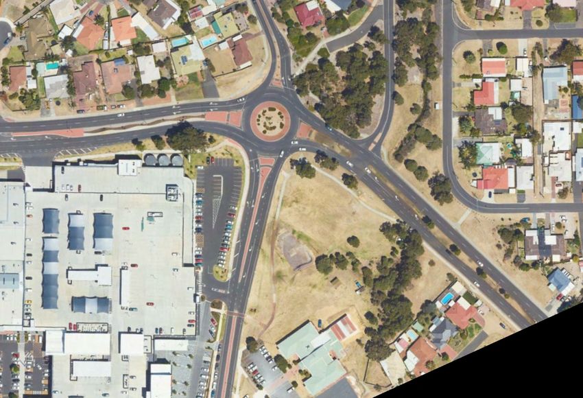
Council Drive / Hamilton Road Intersection
Conversion of existing roundabout to traffic signals is unlikely to be approved by Main Roads, given Main
Roads position that roundabouts are preferred over traffic signalisation. In order to obtain Main Roads
approval the applicant is required to demonstrate that a roundabout is not a suitable form of control, which
would be difficult in this case given that the roundabout exists and appears to be operating well.
As we understand it, the reasons for Council pursuing the conversion to traffic signals is to provide for safer
pedestrian crossing of Eaton Drive and address the problem that drivers are having turning right out of
Council Drive and then left into Hands Avenue. The attached concept plan show how the existing road
geometry could be modified to address both these issues without converting the intersection to signals.
1(Appendix ORD: 12.3.1A)
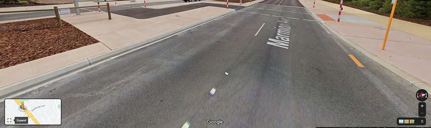
Note that it may also be possible to have the pedestrian crossing of Eaton Drive shown on the plan as a
signalised crossing. Attached is a photo of a signalised pedestrian crossing recently installed near a major
roundabout on Marmion Avenue in Kinross which shows how the staggered crossing shown on the plan
could be signalised.
As part of our assessment of the two options for this intersection, we also prepared a concept layout for the
signalisation (copy attached). Of note, is that the widening of Council Drive to develop the required lanes on
the approach to Council Drive would impact on the existing shopping centre car park.
Hands Avenue Intersection
Restricting the Hands Avenue intersection to Left-in / Left-out could result in a high number of U-turns at
the Frost Way intersection, which would be an undesirable outcome. If the roundabout at Council Drive /
Hamilton Road intersection is retained, a better option may be to also allow the right turn out of Hands
Avenue as shown by the attached concept plan. Features of the concept plan are as follows.
Moving the Hands Avenue intersection further from the intersection will provide significantly better
intersection sight distance to northbound vehicles.
The Eaton Drive median has been widened to allow for a staged crossing of Eaton Drive so that
drivers only have to deal with one direction at the time.
The intersection provides for semi-trailers which are "as of right" vehicles that should, but would
struggle to fit through the existing intersection.
Southbound vehicles on Eaton Drive will be able to get to Hands Avenue by U-turning at the Council
Drive / Hamilton Road roundabout.
New Council Drive Intersection
A new intersection at the proposed location is not desirable because of the closeness to other
intersections. If it is allowed, then it will need to be limited to Left-in / Left-out. U-turning at Frost Way
intersection could be an issue.
Eaton Drive / Forrest Highway Intersection
No issue with proposed double right turn from Eaton Drive. As you are aware, Main Roads already has
developed a plan showing how this can be developed.
Blue Wren Drive and Lavender Way Intersections
No issue with the proposed roundabout at Blue Wren Drive intersection. If Lavender Way intersection is
restricted to Left-in only, then this will reduce the priority from a timing perspective for the roundabout to
be constructed.
Restricting Lavender Way to Left-in only will direct more traffic to the Millard Street / Lofthouse Street
intersection and the proposal for a roundabout at this intersection is therefore supported.
Lofthouse Avenue Intersection
Traffic signals would appear to be the only practical way of achieving additional control at this intersection
because of the site constraints. These signals would need to be linked to the signals at Recreation Drive
during periods of peak flow.
2(Appendix ORD: 12.3.1A)
As previously advised, the double right turn at the Eaton Drive / Forrest Highway intersection is required to
improve the lane utilisation on the southbound approach on Eaton Drive, noting that many drivers are
currently using the median lane because of the difficulty of changing lanes before they get to the Forrest
Highway. It is therefore important that the Lofthouse Avenue traffic signals not be implemented before the
double right at the Forrest Highway traffic signals.
Glen Huon Boulevard Intersection
This site is less constrained than the Lofthouse Avenue intersection and our preliminary investigations
indicate that a roundabout may be feasible. In order to obtain Main Roads approval for traffic signals, you
will need to first demonstrate that a roundabout is unsuitable. For details refer to Main Roads Guidelines
for the Selection of Intersection Control (Roundabouts and Traffic Signals).
Peninsula Lakes Drive Intersection
Traffic signals would appear to be the only practical way of achieving additional control at this
intersection because of the site constraints.
New Council Drive / Recreation Drive Intersection
The proposed connection of the New Council Drive to Recreation Drive creates a short stagger to Cormorant
Entrance. This is a poor outcome, as it will effectively operate as a four-way intersection and make it
difficult to upgrade to a roundabout, which would be a logical treatment if this ever became a black spot. If
this can not be changed, then the closure or partial closure of Cormorant Entrance should be considered.
I hope that you find the above advice useful and please do not hesitate to contact Matt Coppen or myself if you
require any further assistance.
Regards
Lou Palandri BEng, MIE(Aust), CPEng
PROJECT MANAGER DEVELOPMENT
Telephone: (08) 97245600 Mobile: 0419904090
From: Luke Botica
Sent: Thursday, 25 March 2021 11:18 AM
To: PALANDRI Lou (On Leave) ; COPPEN Matthew (PMD/A)
Subject: Eaton Drive Proposed Intersection Treatments
Hi Lou and Matthew
I am just following up on any feedback you have regarding the proposed intersection treatments along Eaton Drive.
We are preparing to commence public consultation in April. We are not able to start this process until we have
MRWA support on the proposed intersections (as per Council resolution on the matter).
Please let me know if you wish to discuss it further. Nathan and I will be at your offices for a BORR meeting
tomorrow morning if you need to catch up with us.
3(Appendix ORD: 12.3.1A)
Thanks for your help on this project.
Kind regards
Luke
Luke Botica
Director Infrastructure
Shire of Dardanup | 1 Council Drive | PO Box 7016 | Eaton WA 6232
p: 08 9724 0367 | m: 0427 447 050 | e: Luke.Botica@dardanup.wa.gov.au
“This message contains privileged and confidential information intended only for the use of the addressee or
entity named above. Use of this information beyond this intended use is unauthorised”
4(Appendix ORD: 12.3.1A)
(Appendix ORD: 12.3.1A)
(Appendix ORD: 12.3.1A)
(Appendix ORD: 12.3.1A)

SCALE   1:500   I:\Bunbury Projects\z-Local 2080202 - Eaton Drive\0.88_slk_Council_Ave_Roundabout_pcg84\drawings\Sketches\eaton-dr-council-ave-roundabout-lou-v7.dwg 15 April 2021
RISK ASSESSMENT TOOL
OVERALL RISK EVENT:                 Changes to Strategic Intersection Treatments on Eaton Drive
RISK THEME PROFILE:

6 - Engagement Practices

RISK ASSESSMENT CONTEXT:            Project
                                                   PRIOR TO TREATMENT OR CONTROL                                                         AFTER TREATEMENT OR CONTROL
CONSEQUENCE                                                                                  RISK ACTION PLAN
                  RISK EVENT                                                    INHERENT                                                                             RESIDUAL
CATEGORY                                       CONSEQUENCE      LIKELIHOOD                   (Treatment or controls proposed)        CONSEQUENCE     LIKELIHOOD
                                                                               RISK RATING                                                                          RISK RATING
                                               Not Required -
                  No risk event identified                                                                                                               Not            Not
HEALTH                                            No Risk          N/A             N/A       Not required.                           Not required.
                  for this category.                                                                                                                  required.      required.
                                                 Identified
                  The loss of external         Not Required -
FINANCIAL                                                                                                                                                Not            Not
                  funding     should    the       No Risk          N/A             N/A       Not required.                           Not required.
IMPACT                                                                                                                                                required.      required.
                  project not continue.          Identified
                                               Not Required -
SERVICE           No risk event identified                                                                                                               Not            Not
                                                  No Risk          N/A             N/A       Not required.                           Not required.
INTERRUPTION      for this category.                                                                                                                  required.      required.
                                                 Identified
                  The potential of legal
LEGAL AND         action against Council for                                   Moderate (5   Develop appropriate designs        to
                                               Moderate (3)     Unlikely (2)                                                          Minor (2)      Unlikely (2)   Low (1 - 4)
COMPLIANCE        not mitigating the risk                                        - 11)       mitigate the risk of accidents.
                  accidents
                  Not mitigating risk of
                                                                                             Develop an appropriate project
                  accidents    and    poor                                      High (12 -                                                                          Moderate (5
REPUTATIONAL                                   Moderate (3)     Possible (3)                 delivery framework to mitigate the      Moderate (3)    Possible (3)
                  communication        and                                         19)                                                                                - 11)
                                                                                             risk
                  Community consultation.
                                               Not Required -
                  No risk event identified                                                                                                               Not            Not
ENVIRONMENT                                       No Risk          N/A             N/A       Not required.                           Not required.
                  for this category.                                                                                                                  required.      required.
                                                 Identified
                                                                                                                                                                                  (Appendix ORD: 12.3.1B)
RISK ASSESSMENT TOOL
OVERALL RISK EVENT: Regional Road Safety Program – Local Government Roads
RISK THEME PROFILE:
1 - Asset Sustainability Practices
RISK ASSESSMENT CONTEXT: Operational
PRIOR TO TREATMENT OR CONTROL AFTER TREATEMENT OR CONTROL
CONSEQUENCE RISK ACTION PLAN
RISK EVENT INHERENT RESIDUAL
CATEGORY CONSEQUENCE LIKELIHOOD (Treatment or controls proposed) CONSEQUENCE LIKELIHOOD
RISK RATING RISK RATING
Not undertaking Construct proposed treatments in
treatments at these Catastrophic compliance with Federal and State Moderate (5
HEALTH Possible (3) High (12 - 19) Major (4) Unlikely (2)
locations may result in (5) Blackspot Programs & Regional Road - 11)
further accidents. Group program.
Risk that assets are not
FINANCIAL Moderate (5 Not Not
upgraded or created to Moderate (3) Possible (3) Not required. Not required.
IMPACT - 11) required. required.
meet demand.
Not Required -
SERVICE No risk event identified Not Not
No Risk N/A N/A Not required. Not required.
INTERRUPTION for this category. required. required.
Identified
Not Required -
LEGAL AND No risk event identified Not Not
No Risk N/A N/A Not required. Not required.
COMPLIANCE for this category. required. required.
Identified
Council may receive
negative publicity for not
Moderate (5 Not Not
REPUTATIONAL addressing accidents Minor (2) Likely (4) Not required. Not required.
- 11) required. required.
which are eligible for
RRSP funding.
Not Required -
No risk event identified Not Not
ENVIRONMENT No Risk N/A N/A Not required. Not required.
for this category. required. required.
Identified
(Appendix ORD: 12.3.2)RISK ASSESSMENT TOOL
OVERALL RISK EVENT: Dardanup Church Access Road – Proposed Road Upgrade
RISK THEME PROFILE:
1 - Asset Sustainability Practices
3 - Failure to Fulfil Compliance Requirements (Statutory, Regulatory)
RISK ASSESSMENT CONTEXT: Project
PRIOR TO TREATMENT OR CONTROL AFTER TREATEMENT OR CONTROL
CONSEQUENCE RISK ACTION PLAN
RISK EVENT INHERENT RESIDUAL
CATEGORY CONSEQUENCE LIKELIHOOD (Treatment or controls proposed) CONSEQUENCE LIKELIHOOD
RISK RATING RISK RATING
Not Required -
No risk event identified Not Not
HEALTH No Risk N/A N/A Not required. Not required.
for this category. required. required.
Identified
Works are unbudgeted
FINANCIAL Moderate (5 Not Not
and may impact on other Minor (2) Possible (3) Not required. Not required.
IMPACT - 11) required. required.
capital works programs.
Not Required -
SERVICE No risk event identified Not Not
No Risk N/A N/A Not required. Not required.
INTERRUPTION for this category. required. required.
Identified
Failure to seek Council
approval for unbudgeted
LEGAL AND Moderate (5 Not Not
expenditure in Moderate (3) Unlikely (2) Not required. Not required.
COMPLIANCE - 11) required. required.
accordance with the
Local Govt Act 1995.
Road quality does not
meet the expectation of Moderate (5 Not Not
REPUTATIONAL Moderate (3) Unlikely (2) Not required Not required.
the adjoining property - 11) required. required.
owners.
Failure to seek Council
approval for unbudgeted
Moderate (5 Not Not
REPUTATIONAL expenditure could been Moderate (3) Unlikely (2) Not required Not required.
- 11) required. required.
seen in a negative light by
the community.
Not Required -
No risk event identified Not Not
ENVIRONMENT No Risk N/A N/A Not required. Not required.
for this category. required. required.
Identified
(Appendix ORD: 12.3.3)KEY OF PROPDSED LANDSCAPE WORKS LEGEND
EXISTING FEATURES
A AP- Existing light posts - reccrnmend renewal / upgrade as required 7 - At Scouts end
Toilets
B Access driveway
C Informal car parking
D Informal canoe launching area Proposed now local native trees (suggest Agonis flexuosa - WA Peppermint)
E Popular fishing area
F (recommended to be same material as proposed new River Heritage Trail)
Popular dog swim beach
G Services - covers (maintain access)
H Concrete path from car park to toilets Proposed now 2m wide concrete path link to match existing
J Maintenance vehicle access point
K Bore pump / irrigation controls
L Flood lights near toilets Proposed now crushed limestone path to match existing, to link bridge
OS Open space area - reticulated turf
with existing path along reserve (possibly seal in future, see below)
STAGE 1- RECOMMENDED WORKS 2020-21 (subject to funding)
1 Proposed iron filtration unit and enclosure
2 Proposed cement stabilised limestone path to link bridge to existing path Possible future new 2.5m wide sealed red coloured universally accessible pathway
(possibly seal in future with universally accessible material) (recommended to be sane material as proposed new River Heritage Trail)
with possible heavy logs along car park side of path to restrict vehide access
(suggest to replace logs in future with bollards)
3 Proposed shade shelter with accessible picnic setting Possible fulure circuit path link 2m wide
4 Proposed link path from toilets to river side path via gazebo to link with
River Heritage Trail project(due to be constructed in 2019-20)
5 Proposed low square multi-use seating platforms
Possible new future artwork location
6 Proposed doible bin enclosures
7 Proposed park welcome signage and possible code of shared use
(2 signs near car park in main part of reserve, 1 sign at Scouts end)
8 Proposed removal of existing U-bar in path
9 Proposed seat adjacent pa:h, near popular dog swim beach
10 Proposed renewal / upgrace of reserve lighting, as required
11 Make 'dog swim beach' safer by removing submerged rocksl2
Proposed new tree planting - suggest Agonis flexuosa (WA Peppermint)
13 Proposed installation of nesting boxes fcr native micro-bats (locate on site)
14 Retain and refurbish existing memorial seat; suggest relocating in future
onto 'future possible new rver river platform' (as identified in item 16 below)
General notes:
Recommended natural look and feel wherever possible,
including timber-look materials and earthy colours
Proposed retention of stumps and logs for dog play features and for habitat
FUTURE POSSIBLE WORKS (subject to funding)
15 Possible new 2.5m wide universally accessible path surfacing from
bridge to northern extent o' reticulated turf
16 Possible new river fishing rlatform - suggest a leaf shaped fixed deck
17 Possible renewal of existing gazebo and new accessible ramps
18 Possible drink fountain with dog bowl
19 Possible additional reservesignage including directional / informational
20 Possible upgrade to car parking - recommend natural look 'earth coloured'
surfacing (subject to detailed design)
21 Possible future parking area for trailers (work around existing trees - retain)
22 Possible future mobile trader bay (workaround existing trees - retain)
23 Possible modfication to access driveway entrance and bottom end, to create
two vehicle pall-over bays br safer vehicle access and egress
24 Possible new maintenance access points, with removable bollards
25 Possible future path circuit linking toilets with proposed new river platform
26 Possible new vehicle exclusion bollards around car park (e.g. composite
material) to replace existing bollards, limestone blocks and temporary logs
27 Possible future bicycle parking
28 Possible interpretive signage — to tie in with upcoming River Heritage
Trail project (2019-20)
29 Possible future refurbishment of steps at 'dog swim beach'
DESIGN OBJECTIVES
Recommend future environmental works including bushland weed removal 1 To preserve and enhance the natural landscape character of the reserve
and river bank erosion mitgation works (subject to funding) 10 -On 2 To improve access and inclusion opportunities for people of all abilities and their dogs
Possible future security camera - suggest on hinged pole and with sensor 3 To improve safety and security (real and perceived) for reserve users
light, in mostsuitable location with view to car park and toilets 4 To provide additional landscape amenities to enhance visitor comfort and experiences
Possible additional dog waste bag dispensers, if required 5 To protect and enhance the natural environment, Including the riparian edge, flora and fauna
Possible opportunities for 'art in the park' - e.g. dog themed / native fauna 6 To create opportunities for physical and social connectivity, including path links and cultural expression
Possible future improvements near the Scout Hall including to the river ,///
1.1rik via existing bridge and
platform and the access way, plus a new retaining wall adjacent the path 40 steps to Hear walk paths
aB DIAL BEFORE
YOU DIG
www.1;00.aeneu
AMENDMENT DESCRIPTION BY DATE APPR DESIGNED DRAWN DATE SURVEYED DRAWING TITLE
VP 20/11/2018 ENGINEERING &
JOB NUMBER.
WATSON RESERVE
DRAWN AUTHORISED
PRATT ROAD, EATON DEVELOPMENT SERVICES
VP LB J11615
(Appendix ORD: 12.3.4A)
GENERAL NOTES DRAWING NO. YEAR SHEET REVISION
T1
,
170
DrAPACATZS REMAIN THE PROP RTY or THE SHRE 4" DAMAN. ARO RR/ST NOT BE R ETAINED OR REPRODUCED Shire of Dardanup
LANDSCAPE CONCEPT PLAN - DRAFT
111,
T.FlEatniC
otff;r7VMD4IGNATI/RE fle DIRECTOR M.S.. AND DEVELOPMENT SEAVICE•THM DRAVA.
AdmInIstra5on Conte Eaton Telephone 08 9724 0000
1 ALL DINERS101.13 ARE IN METRE UNLESS NOTED OTHER.. PROPOSED LANDSCAPE IMPROVEMENT WORKS R25417-18-600-1-A
• ANNOTATED DitiENSIONS S.I.ALWAYS TAKE PRECEDENCE OMER SGIES DISTANCES P.O Box 7017-1 Ccuncplarive Faceir.le 08 9724 00)1
NOTE DATUM. DATUM SHEET NO Eaton Western MOOR 6232 Online www.dordinup we gov.01.1
PLAN FOR PUBLIC COMMENT Not to standard scale
:6ircrArAeurjalag« 1 ii8eTanfajWcIli..1218. .72.-rT5,9.9-
c* ,...siracrT0841,1-"Vrrin10,97nceR
`` GRID. SYSTEM GRID 4 A3 ABN 57 3)5 829 653Watson Reserve Concept Design – Submission Table March 2019 (updated May 2020)
All comments and feedback received during the public consultation period are summarised in the table below.
Full names recorded on the original draft submission table in 2019 have been abbreviated to a title and initial to protect respondents’ privacy.
Respondent Respondent Comment Officer Comment
Community
members:
1. Mr G. I regularly use Watson Park Reserve for my dog. I like it the Noted.
way it is and only really needs a few minor things that look
like they’re going to happen anyway.
The only other thing I suggest is another gazebo at the Additional shelter has been proposed for near the bridge
bridge end of the grassed area. It'd be great especially in end of the reserve.
winter time.
Oh and maybe a few more benches to sit on along the Additional seating has been proposed in the reserve and
side of the river. along the path.
2. Ms G. I have perused the draft concept plan for Watsons Reserve Any proposed signage relating to the reserve’s use as an off
and have a few queries and suggestions, which I will list leash dog exercise area will aim to be ‘friendly’ in style and
below. reinforce the requirement for dog owners to be in control of
Regarding 7 (&19) Signage - what will "shared "use" their dogs at all times, in accordance with the relevant Local
statement be? Will it reference "leash free area" and the Laws.
need for dog owners to CONTROL their dogs? NB: Response to submitter’s questions sent 6/3/2019
I regularly walk the trails along the Collie River and find that Noted.
many dog owners are apparently oblivious to their dogs’
whereabouts and actions, and most often do NOT call
their dogs away from certain situations.
Will there be upgraded signage at the top of the Upgraded signage can be considered for the top of the
driveway? Will it reference the shared use driveway, can it driveway. This – including the request for mention of a speed
have a 'speed limit'? limit – will be raised with the engineering design team who
look after the Shire’s roads.
And can dog exercise sign also state that owners MUST still Yes, this is intended.
control their dogs? Many other parks in the region do
have signs stating this.
12 (not numbered) Tree planting - Why is the proposal for Agonis flexuosa has been nominated as a focus tree species
(Appendix ORD: 12.3.4B)Respondent Respondent Comment Officer Comment
Dog poo bags - Almost pointless having the dispensers The Shire’s Parks and Environment team who are responsible
when very often there are NO bags in them. Who is for the replenishment of dog waste bags will monitor the
responsible for refilling these? Weekends from Friday supply of bags and top up as required.
afternoons often have large numbers of walkers and fishers
with dogs, and empty poo bag dispensers. Hard enough
to get some people to pick up after their dogs, but when
there are no bags, then much poo is left for people to step
in.
3. Ms F. First I hope no trees are going to be removed at all for this It is not proposed to remove any existing trees unless there
work to be done along the river flats. Their age and size are are any identified down the track to be hazardous to public
beautiful. It looks like the car park is planted on the safety. The car parking shown on the plan is indicative only
peppermint tree alongside the existing path. Don't take this and shown as ‘subject to detailed design’ – through which
out! every effort will be made to work around existing healthy
trees, ensuring that they are retained and protected. A brief
note to this effect can be included on the revised plan.
Second, where is the board walk in the design. It is an The advertised draft plan focused primarily on the main
important part of this area that needs to remain as it is open space area of Watson Reserve which is why the
used often. boardwalks did not appear on the original draft plan. The
plan can be amended to show the boardwalks. They are
valued by many reserve users and an important part of the
pathway access system through the reserve so it is intended
for them to be retained and improved as required and as
funds allow.
4. Ms R. The draft plan looks really good although I am still The proposal for a new picnic shelter and setting near the
concerned about the addition of a “good shade shelter popular fishing spot and proposed river platform may help to
with accessible picnic setting” as this apparently has to be provide an 'off the ground' picnic and general seating
a shared-use area. I am hoping that people who do not opportunity, as it is understood from comments received
have a dog will prefer to use the Foreshore park…… that misunderstandings can occur when dogs rush over and
although I think the shade shelter and picnic setting may jump on people who might be sitting on the ground having
encourage people to go to Watson’s Reserve for that a picnic. A raised table may help to reduce the incidence of
reason. I say this because having spoken to a number of such a situation occurring. The proposed picnic shelter has
regular dog owners who use the park, people without dogs been intentionally located at the other side of the park to
can sometimes be very confronting. where the dog exercise group generally tends to gather, to
(Appendix ORD: 12.3.4B)Respondent Respondent Comment Officer Comment
only Peppermint (Agonis) trees. The area has a very in this reserve in order to create a more connected canopy
diverse number of endemic trees, and already has an as refuge (for habitat and food) for the Western Ringtail
abundance of Peppys. Possum which has been found in this reserve. This species is
It would be preferable to have a more diverse range of listed as Critically Endangered fauna under the Biodiversity
trees including Acacias, Casuarinas, Banksias, Acers & Conservation Act 2016 which has informed the Shire’s design
some smaller species Eucalypts. I am certain the including tree species selection. Acer would not be
Leschenault Native Nursery can help with the choices, and considered for this Reserve as the focus in this location is for
a diverse range of trees will bring a diverse range of birds local native trees only. Other local native species could be
and insects to pollinate the various flowers they will considered.
produce. Please retain all current trees.
23 Access Driveway - Why is there only 'future proposal' This is noted as a future proposal since any significant work
regarding the driveway? This is a dual use driveway with on the driveway would be subject to feasibility (with a steep
many walkers & cyclists also accessing Watsons Reserve drop off on either side into existing wetlands, with significant
via the driveway. What are the 'shared use' rules for the earthworks and potential wetland environmental impacts)
existing driveway? Is it "might has right", which seems to be and to funding. This can also be raised with the Shire’s road
the case, as I have yet to meet up with a driver willing to engineering team.
wait mere seconds for any walker (with or without dog/s), There are not currently any advertised rules posted on
or cyclists. There is very little room to stand aside for an driveway signage however this can be considered.
often fast moving vehicle/s. The driveway needs work and
widening now, not in future. As the driveway has a bend in
it, the vision line is poor & it can be difficult to see if there is
a vehicle oncoming. Very many times I have watched a
vehicle reversing back to either top or bottom of
driveway.
When will the bridge be upgraded? I spoke with a Upgrading the bridge can be included in the amended
gentleman from the Shire last year when I came across him master plan; this will be subject to budget and the timing
measuring the bridge and pillars. He said that the wood subject to scheduling of works in the Shire’s ten year asset
was disintegrating and the Shire was planning to upgrade management plans.
it to make it safer.
Sprinklers - these are currently doing more damage than Noted. A reticulation system upgrade is being proposed in
good, as they miss huge patches and dig ruts in the grass conjunction with an iron filtration unit and enclosure which
and pathway in several areas and cause erosion. The will help to ensure a more effective reticulation system.
current reticulation system is inefficient. (Update – iron filtration unit installed in 2021)
(Appendix ORD: 12.3.4B)Respondent Respondent Comment Officer Comment
provide shade and seating opportunities for all legitimate
park users - including for dog owners, who may well also
enjoy having a table setting to sit at.
To be honest I don’t know why we cannot just have a While the Reserve is a designated off-leash dog exercise
designated area for unleashed dogs without encouraging area, it is also currently a popular fishing and recreational
people to picnic there which I think is just asking for spot as well as being used by other groups in the community
trouble. I have been confronted on two occasions by such as the Scouts who are based nearby (for occasional
people with picnics on the grass… actually sworn and activities) and Cross Country runners club (for an occasional
shouted at, all because I told them that it perhaps wasn’t - possibly annual - running event.) It is not currently deemed
such a good idea to have a picnic on the grass with loose feasible nor fair to try to exclude any particular group from
dogs around. the Reserve as it is enjoyed by many people for different
reasons and is proposed to remain as a shared use space,
therefore it is not intended to be nominated in the concept
plan or any subsequent detailed designs or management
plans as a 'dog exercise only' area.
5. Mr B. There is no plan to fix up the waters’ edge and get rid of The Shire is presently working with adjoining Local
the ugly boulders. Government areas and the Department of Water and
This was once a great family area for kids to swim in the Environmental Regulation on the Lower Collie River Master
river and even had a rope swing to swing out into the Plan project, which is considering erosion mitigation and
water. If a limestone wall was to be built to protect the river water quality along and in the river. The objective of this
bank and some steps to get into the water it would project is to plan a comprehensive solution across the whole
enhance the use by the greater public. of the river, and as working in one area will affect all other
parts of the river it will be done with a strategic plan in place.
Watson Reserve is being considered within the overall
context of this project and it is advisable to wait until an
overall strategy for the river is in place prior to undertaking
significant localised erosion control works. The Director of
Infrastructure has confirmed that the plans can be updated
to include the recommended treatments which could also
include some sections of limestone wall or other retaining
wall (e.g. sheet piles etc).
Placing a jetty to encourage boating people to use the A 'fishing platform' (in effect a multi-purpose deck
park and toilet facilities, this may encourage more river overhanging the water) has been proposed in the concept
(Appendix ORD: 12.3.4B)Respondent Respondent Comment Officer Comment
cruises to barbecue at this location. plan. This was intentionally kept subtle in form and scale, as a
majority of the respondents did not want to see too many
changes which might result in further user group conflicts
and in dogs potentially being excluded from this 24/7 off
leash dog exercise area. The merits of a jetty (e.g. floating
style out into the water) versus a smaller deck along the
shore could be investigated through detailed design,
including funding opportunities through the Department of
Transport.
A majority of respondents in the initial consultation in 2018
explicitly requested that no BBQ's be installed in the reserve
for this reason. As such, no BBQ has been included on the
master plan. This could be reconsidered in future should the
community come forward with considerable support for a
BBQ in this location, as the picturesque river setting and
presence of existing toilets do support the provision of a BBQ.
This location has also been used for weddings in the past It is acknowledged that this is a venue enjoyed by various
and if we place to big a canopy of trees the grass will not groups for gatherings including for special celebrations. The
grow to enhance the picturesque location. intent of additional tree planting is to create a more
continuous canopy for the existing community of
Endangered Western Ringtail Possums to be able to safely
move through the reserve to forage out of reach of any
visiting dogs or other potential threats. New plantings are
intended to be clustered, to allow for 'copses' of trees to
form and canopies to touch in points, but to still retain plenty
of areas where the sunlight permeates through to the
ground. Native shade-tolerant alternatives or supplements to
the existing turf could be considered.
Has any investigation or contact been made with the Names of recommended local elders to speak to about the
Aboriginal sector to see if this is a significant heritage stories of the Collie River in this area were sought from the
location, my reason for this question is 45yrs ago when I South West Aboriginal Land and Sea Council in 2018 and
moved into this area almost every weekend for over 20yrs subsequently provided. It is proposed that consultation with
indigenous families from the region would be swimming the appropriate elders take place prior to any interpretive
(Appendix ORD: 12.3.4B)Respondent Respondent Comment Officer Comment
and fishing for crabs in the estuary and cooking them at signage being produced, in order to incorporate local
this location. Indigenous cultural heritage stories into the site. The
publication 'Nyungar Values of the Collie River' (Beckwith
Environmental Planning, for the Department of Water March
2009) as well as the Shire of Dardanup Local Heritage Survey
(2016) has been referred to in the design process however it
would be appropriate to also refer the plan to the relevant
local Noongar contacts for input prior to any landscape
improvements being implemented.
When a member of the Leschenault Management Noted; to be considered in relation to any future erosion
Authority, that group built all the laterite retaining walls mitigation improvements.
which have since been destroyed because of a lack of
maintenance and the answer seems to be put boulders or
building rubble which is full of chemicals onto the river bed
to stop erosion.
Has there been a fire strategy produced for this area due A dedicated fire strategy has not yet been prepared for the
to only one exit by vehicle and three by foot going through Reserve however the Shire's Bushfire Risk Planning
the fire fuel area. Coordinator was consulted in 2018 and provided advice
with respect to bushfire considerations. The main
recommendation was to ensure that the firebreaks between
the Reserve and adjoining private properties be maintained,
which is an important operational consideration. It is
intended to retain and protect the existing wetland for
environmental reasons and in line with the consultation
outcome of ‘keeping the reserve as natural as possible’ in
addition to which the wetland itself could be seen as a fire
dampening ‘buffer’. In the event of a fire in the bush
surrounding the reserve, people may be more likely to head
towards the river rather than through the access driveway
and paths.
There needs to be pram access for young people to get to The bridge from the base of the existing steps across into
the park safely. Watson Reserve was nominated as the site 'boundary' for the
(Appendix ORD: 12.3.4B)Respondent Respondent Comment Officer Comment
purposes of this project. A potential long term future project
idea, subject to considerable grant funding, could be to
create an accessible zig-zag form 'skywalk' (ramped sections
of platform through the bush, avoiding high value remnant
vegetation) from the southern end of the bridge up to the
lookout, to allow bicycles, prams and other wheeled mobility
devices to more safely access the main part of the reserve
and connect to the path network along the river. Improved
and safer access into the reserve is worthy of inclusion in the
plan, with any discrete projects being subject to feasibility
and funding considerations. The engineering design team
can consider a possible upgrade of the roadway from Pratt
Road which could provide a shared zone with priority given
to pedestrians (including sign posting to this effect).
External
stakeholders
who
provided
feedback:
DBCA Comments received
Traditional Represented by Local Aboriginal Elders The Plan was referred to then Chairman of the Greater
Owners Bunbury Elders Group in August 2019 but
Update May 2021: The Amended Plan was presented to
Aboriginal Elders including the Traditional Custodian of the
Collie River, Mr Joe Northover, at a meeting in March 2021.
The Elders consulted were supportive of the plan and did not
express any concerns or objections to proposals in the Plan.
External
stakeholders
who
declined to
provide
feedback or
(Appendix ORD: 12.3.4B)Respondent Respondent Comment Officer Comment
who did not
reespond:
DBCA Comments received
(Appendix ORD: 12.3.4B)(Appendix ORD: 12.3.4C)
(Appendix ORD: 12.3.4C)
(Appendix ORD: 12.3.4D)

WATSON RESERVE MASTER PLAN

       PLAN REPORT

         MAY 2021
(Appendix ORD: 12.3.4D)
Shire of Dardanup
ADMINISTRATION CENTRE EATON
1 Council Drive - EATON
.(Appendix ORD: 12.3.4D) 3
WATSON RESERVE MASTER PLAN
T AB L E O F C O N T E N T S
1. ABOUT WATSON RESERVE ....................................................................................................................... 4
2. CURRENT USE OF THE PARK ................................................................................................................... 11
3. REDEVELOPMENT OPPORTUNITIES/VISIONS ......................................................................................... 13(Appendix ORD: 12.3.4D) 4
WATSON RESERVE MASTER PLAN
1. ABOUT WATSON RESERVE
Site location and context
Watson Reserve is a 7ha Shire of Dardanup Reserve (R 25417) located adjacent the Collie River at Lot
5536 Pratt Road, Eaton. Its main access way is the driveway at the northern end of Watson Street. It
is part of the Regional Open Space network and is included in the proposed Kalgulup Regional Park.
Nearby parks and reserves accessible via the existing path network include Leicester Ramble and
associated wetlands, the Charolais Mews linear bush reserve, the Pratt Road bush reserve and the
Eaton Foreshore further to the southwest. Below is an aerial image from May 2021.
Under the applicable Shire of Dardanup Town Planning Scheme, the adjoining private land holdings
on Leake Street whose fences abut the reserve fire break (Lots 1-10) are zoned as R12.5, with a
classification of Bushland Development Area. Other residential properties across the road from the
reserve are zoned R30.
Site Assessment
Watson Reserve is a high value environmental and recreational area. It has a secluded, intimate and
tranquil quality, bounded by the river and natural bushland, with a strong sense of nature
connection. The reserve is located within the flood fringe of the Collie River thus access through the
reserve varies seasonally, with winter bringing a greater level of inundation and occasionally
rendering some areas inaccessible.(Appendix ORD: 12.3.4D) 5
WATSON RESERVE MASTER PLAN
Visual water access is good, with views to the Collie River primarily from the open park area and from
along the existing limestone pathway along the river. Most of the riverine edge of the reserve is more
difficult to access physically due to existing rockwork (installed to mitigate the impacts of erosion) and
some existing clumps of riparian vegetation, however there are some existing access points including
a small beach popularly used for launching canoes and a ‘dog beach’ to the northern end of the open
space area, popular for dogs to enter the water for a swim. There is a very close proximity to the water
and opportunities exist through design to extend this experience.
Two distinct main functional areas are apparent – conservation bushland, and usable public open
space. The reserve can be further split into different usage zones, being:
1. Access driveway and car park;
2. Main reserve open space area, including toilets and gazebo;
3. Fishing / canoeing / viewing area near bridge;
4. Surrounding bushland including wetland, with river trails / boardwalks to Scout hall
and to Leake Street, plus firebreaks;
5. Scout hall, northern access point and surrounds;
6. Reserve area north of the Scout Hall (not included in the scope of this project) –
difficult to access and classed as a high value environmental area including
important Western Ringtail Possum habitat.
Existing features
Existing features that have been identified in the reserve include:
• A vehicle access driveway and car park, compacted limestone footpath, some unformed dirt
paths, timber boardwalks and a bridge, and access points on the river for canoes or other
small water craft;
• A crushed limestone path runs along the river along the full extent of the Reserve, which is
used by the community for exercise and for transit;
• A staircase at the far south western corner of the reserve, just beyond the ‘bridge’, is not
universally accessible and the only access/egress point to the main open park area of the
reserve is along the relatively steep access driveway off Pratt Road;
• There are additional pathway links into the reserve at the northern end (near the Scout Hall)
and from a narrow accessway from just north of the junction of Pratt Road and Leake Street.(Appendix ORD: 12.3.4D) 6
WATSON RESERVE MASTER PLAN
• Signage is minimal, focusing primarily on prohibited and permitted activities,
• There is some old informational signage along the river about previously completed
environmental projects, including by the Leschenault Catchment Council;
• Some posts without signs are dotted along the pathway;
• An existing toilet block was painted in 2018 by artist Andrew Frazer with an art mural
featuring a ‘dogs’ theme, assisting to brighten the area;
• An existing old-style timber gazebo is located inbetween the existing public toilet block and
the river;
• There is an existing park seat along the path by the river, known as ‘Sophie’s Bench’, dedicated
to the memory of the late child of two local residents. They wish for a memorial plaque to be
installed on the bench and to be consulted if any changes are proposed to this bench in the
future;
• There is currently no connecting path linking the toilets directly to the gazebo or river;
• There are existing wheelie bins on stands;
• There is an existing bore, pump and reticulation system located in the open space area of
the reserve. Problems have been experienced over the years from the accumulation of
residue from relatively high iron levels in the bore water, resulting in blockages, low flow
pressure and resultant inadequate reticulation coverage to the turf and pitting of the path
and surrounding ground surface from heavy water droplet throw;
• An iron filtration unit and enclosure, which was recently installed;
• Lights along the river, plus two floodlights near the toilet block;
• A dog water bowl and tap on the toilet wall, plus dog waste bag dispensers;
• Existing treated pine bollards and limestone blocks are the current means used to restrict
unauthorised vehicles from entering the open space areas of the reserve;
• Maintenance vehicle access is currently through a boom gate in the main car park;
• There are a number of water access points for people and dogs visiting the reserve, including
several small ‘beaches’ – a popular one is located just north of the main reticulated turf
area, where the Leake Street connector path joins the main riverside path;
• Anti-erosion measures have been implemented along the river’s edge over time including
rock armature;
• There are services located within the reserve, with concrete lids set flush with the ground
located at the southern end of the open space area of the reserve.
Risks and hazards
Risks that have been identified in the reserve include:
• River risk (no signs in place) – including deep water, submerged or possibly unstable /
slippery rocks, riverbank erosion including washouts and fallen trees;
• Submerged rocks have been identified as a potential safety hazard for people and dogs at
the ‘dog beach’ area in particular;
• Possibility of personal injury or property damage from any falling tree limbs;
• The possibility of health effects from snake or mosquito bites;
• Seasonally inundated ground, particularly during major rain events and high tides;
• Crime and general anti-social issues, particularly after dark; (lighting has been identified as
currently being insufficient);(Appendix ORD: 12.3.4D) 7
WATSON RESERVE MASTER PLAN
• Access issues – no road markers currently in place over the culvert;
• Uneven surface and occasional drainage problems in the car park;
• Risk of accidents from vehicles ‘hooning’ in the car park;
• Risk to personal and property security from crime or anti-social behaviour in the reserve;
• Potential risk from any conflict between two or more dogs, or between dogs and people;
• Snake activity increases in Spring and can deter some dog owners from visiting the reserve;
• Potential injury to people, dogs or native fauna from fishing waste (hooks and line, blowfish)
left in by the river;
• Potential injury to native fauna, particularly Western Ringtail Possums, by animals including
dogs.
Issues
Accessibility issues
• Access for vehicles – there is only one narrow entrance driveway with no room to pass and
limited space to pull over. The access / egress point on Pratt road is on a blind spot with
double lines, with limited visibility along Pratt road to the west;
• Car parking is fairly informal, without marked bays or circulation system. It extends right to
the river’s edge, cutting the bridge off from the nearby limestone pathway;
• Accessibility for people – particularly linking the toilets, gazebo and existing path network;
• Accessibility for bicycles, gophers, prams or other non-motorised wheeled craft – limited
access in due to the steep steps on the western end of the bridge into the reserve and the
aforementioned narrow driveway. No directional signage;
• Signage – the reserve is not identified by any entrance signage, nor much informational
signage other than highlighting sanctioned (dog exercising) and prohibited (camping)
activities.(Appendix ORD: 12.3.4D) 8
WATSON RESERVE MASTER PLAN
Safety and security issues
• There is limited passive surveillance overall, with no surveillance possible from any nearby
residential properties in Eaton, due to screening from surrounding streets by bushland, and
only limited surveillance from other vehicles accessing the car park and reserve users;
• There is some intermittent surveillance from residents across the river in Australind and
from water craft on the river;
• Police occasionally patrol the car park due to receiving reports of antisocial behaviour,
particularly in the public toilet block and in parked cars;
• A surveillance camera that was placed high in a tree in the reserve was stolen shortly after
installation;
• The lighting along the river pathway did not work at the time of assessment (with no
luminaires in place) and reportedly had not worked for a number of years, causing darker
conditions than are ideal along a path;
• Antisocial behaviour is regularly reported to the Shire and police, particularly in the toilets
after hours, with issues including drug use, vandalism and other unlawful activity;
• Occasional user conflicts between those using the reserve to exercise their dogs off lead and
other reserve users, particularly those using the area for events;
• Asset maintenance – the existing gazebo has exposed treated pine timber posts;
• Glyphosate – users have expressed concerns about the use of non-coloured Glyphosate
herbicide in the reserve, saying that it could cause injury to their dogs from facial exposure;
• Fishing waste and debris – users have expressed concerns about blowfish and other fish
waste, fishing line and hooks being left in the reserve close to the water line, presenting a
risk to people and dogs;
• Vehicles doing ‘bog laps’ in the car park and pushing barriers over to enter the reserve
present a potential hazard to other reserve users and damage the reserve assets;
• Hazard from submerged smaller rocks at water’s edge, particularly at ‘beach’ locations;
• As an area with considerable vegetation cover, bushfire considerations will need to be
addresses including the maintaining of fire breaks between Watson Reserve and adjoining
private properties.(Appendix ORD: 12.3.4D) 9
WATSON RESERVE MASTER PLAN
Amenity issues
• The existing toilets are sometimes vandalised or the subject of other anti-social behaviour,
resulting in reduced amenity for legitimate users of the facilities;
• There is currently no drinking water fountain in the reserve;
• Seating is limited, with only one existing seat adjacent the river;
• There is ample shade from existing trees on site, but opportunity to plant more to enhance
aesthetics and to provide additional fauna habitat;
• Seasonal inundation cuts off access in areas.
Cultural issues
• The Collie River is known to be important to local Noongars as an identified Waugal site
(Collie River as a Registered Aboriginal Site ID# 16713, Department of Planning, Lands and
Heritage). It is important to consult with the identified Noongar elders who can speak for the
area if any cultural information for any potential interpretive signage is sought;
• If interpretive information such as a signage trail with information and art is included in the
works then it is recommended that Noongar input from at least one of the identified elders
be incorporated. This could help to identify art themes for future art trail / other art works in
the reserve and connected open space areas;(Appendix ORD: 12.3.4D) 10
WATSON RESERVE MASTER PLAN
• The current useage of the reserve needs to be acknowledged, being a blend of active and
passive recreation, including use as a dedicated dog off leash exercise area, popular fishing
spot and scenic picnic area.
Environmental
• Watson Reserve is classed as a significant natural asset with a ‘sensitive’ rating, as it is a
reserve within a known environmentally sensitive area;
• The reserve has been identified as existing habitat for the critically endangered Western
Ringtail Possum (Pseudocheirus occidentalis). In Western Australia this species is listed as
fauna that is rare or likely to become extinct (Specially Protected) under the Wildlife
Conservation Act 1950. Western ringtail possums are only found in the south-west of
Western Australia;
• There is noticeable erosion along the river banks including washouts from river craft, which
compromise the structural integrity of trees on the water’s edge whose roots are important
for bank stabilisation;
• Riparian vegetation has been degraded in some areas such as by trampling from foot traffic,
further exacerbating the problem of river bank erosion;
• Inundation occurs seasonally, and quite regularly through winter, restricting access through
the reserve and washing away sections of path;
• Weed infestation has been identified as a significant issue, particularly closer to the
residential property boundaries;
• Class 1 and 2 Acid Sulfate Soils may be present;
• The water quality entering the reserve’s wetland system from the roadways has been
highlighted as an issue to investigate, as it may impact the health of the vegetation and
waterway;
• People have been reported as setting illegal fishing nets off the bridge at the southern end;
• The reserve wetland areas are a known site for breeding waterbirds who need vegetation as
protection from other animals including feral cats and foxes. The vegetation provides more
cover for such species to breed in more relative safety. The vegetation in the fringing
wetland allows for improved water filtering, and helps to prevent flooding;
• The Lower Collie River Masterplan project in 2019 involved mapping sections of the Collie
River, including along Watson Reserve, with the aim of planning for future river bank erosion
mitigation works;
• An Erosion management Plan has recently been prepared by a coastal engineer, which
outlines the hot spots for erosion and what can be done to repair it. Protecting all of the
riparian (fringing wet) vegetation along the Collie river at Watson Reserve is an important
step in flood management in the area as well as protecting vulnerable eroded shoreline from
storm events. This report will go to Council towards the end of the 2021;
• Planting additional trees is proposed, particularly Agonis flexuosa, to protect the existing
population of Western Ringtail possum is important, as the current trees are old and over
time will die of old age and won’t be replaced unless a program is put in place now. Possums
need these trees for food, habitat and refuge. Planting clumps of 2-5 near one another will
ensure that possums have safe passage to reach the canopy cover of existing trees without
having to go to ground, where they are vulnerable to attack from other animals.
• Fauna boxes to encourage native micro-bats to nest in the reserve area could assist to
naturally reduce mosquito population (supported for trial by the Shire’s PrincipalYou can also read