CAPE PATTON TO SKENES CREEK TRAIL ALIGNMENT FEASIBILITY STUDY - PREPARED BY WORLD TRAIL PTY LTD FOR THE DEPARTMENT OF ENVIRONMENT, LAND, WATER AND ...
←
→
Page content transcription
If your browser does not render page correctly, please read the page content below
CAPE PATTON TO SKENES CREEK
TRAIL ALIGNMENT FEASIBILITY STUDY

                PREPARED BY WORLD TRAIL PTY LTD

           FOR THE DEPARTMENT OF ENVIRONMENT,
                      LAND, WATER AND PLANNING

                                  FEBUARY 2021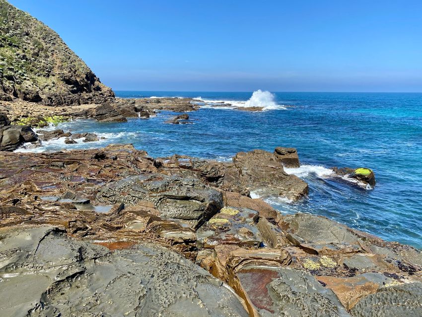
Cape Patton to Skenes Creek Trail Alignment Feasibility Study                                  World Trail Pty Ltd

    World Trail wishes to acknowledge the Traditional Owners of the area, the Eastern Maar, and pay our
                               respects to Elders past, present and emerging.

  We extend that respect to all Aboriginal and Torres Strait Islander people and recognise their rich cultures
                                and continuing connection to land and waters.

                                                                .

                                                                                                                     i
Cape Patton to Skenes Creek Trail Alignment Feasibility Study                                   World Trail Pty Ltd

Disclaimer
This document, Cape Patton to Skenes Creek Trail Alignment Feasibility Study, has been prepared by World
Trail Pty Ltd for the Department of Environment, Land, Water and Planning. This document is the work of
World Trail and does not necessarily reflect the final views or opinions of all stakeholders. It has been
prepared in accordance with the relevant federal, state and local legislation and current industry best
practice. World Trail accepts no liability for any damages or loss incurred as a result of reliance placed upon
the report content or for any purpose other than that for which it was intended.

Version Control
            Version                            Date                      Author                Notes
 Draft                            29/1/2021                     G. McHugh
 Draft                            8/2/2021                      B. Isaac             Incorporating DELWP
                                                                                     feedback
 Draft – Final for                9/2/2021                      G. McHugh            Final DRAFT report for
 Endorsement                                                                         DELWP endorsement
 Final                            15/2/2021                     B. Isaac             Final report issued

                                                                                                                  ii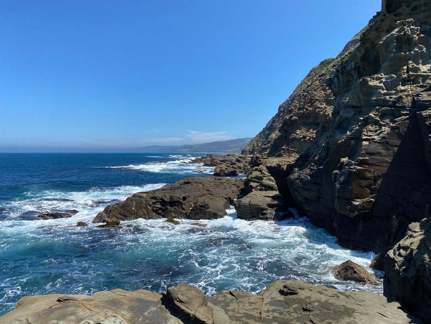
Cape Patton to Skenes Creek Trail Alignment Feasibility Study                                                                               World Trail Pty Ltd

CONTENTSS
1      EXECUTIVE SUMMARY ........................................................................................................................ 1
2      INTRODUCTION .................................................................................................................................. 4
3      PROJECT OBJECTIVES .......................................................................................................................... 7
4     DESKTOP REVIEW ............................................................................................................................... 9
    4.1 FAIRHAVEN TO SKENES CREEK COASTAL TRAIL FEASIBILITY STUDY FINAL REPORT .............................. 10
    4.2 PRELIMINARY TRAIL ALIGNMENT OPTIONS .......................................................................................... 12
      4.2.1   Trail Alignment Option 1 – Between Beach and Road, Conventional Trail ................................ 13
      4.2.2   Trail Alignment Option 2 – Between Beach and Road, Engineered Structure ........................... 15
      4.2.3   Trail Alignment Option 3 – Beach or Rock Shelf, No Treatment ................................................ 17
      4.2.4   Trail Alignment Option 4 – Road Corridor ................................................................................. 19
      4.2.5   Trail Alignment Option 5 – Rock Shelf, Engineered Solution ..................................................... 21
      4.2.6   Trail Alignment Option 6 – Above Road (Private Property), Conventional Trail ........................ 24
    4.3 DESKTOP ALIGNMENTS ......................................................................................................................... 25
5     STAKEHOLDER ENGAGEMENT ............................................................................................................26
    5.1 COLAC OTWAY SHIRE COUNCIL ............................................................................................................. 27
    5.2 DELWP ................................................................................................................................................... 27
    5.3 OTWAY COAST COMMITTEE ................................................................................................................. 28
6      FIELDWORK METHODOLOGY .............................................................................................................29
7     FINDINGS ...........................................................................................................................................36
    7.1 TRAIL SEGMENTS ................................................................................................................................... 37
      7.1.1    Other Considerations ................................................................................................................. 42
    7.2 ROUTE OPTIONS ANALYSIS.................................................................................................................... 43
    7.3 PREFERRED ROUTE OPTIONS ................................................................................................................ 50
      7.3.1    Coastal Route with Inland Section Via The Rise and Down Carisbrook Creek (Routes BL and
      BM)      52
      7.3.2    Inland Route Via Carisbrook Creek ............................................................................................ 54
      7.3.3    Inland Route Via Smythe’s Creek ............................................................................................... 56
    7.4 RECOMMENDED ROUTE OPTION .......................................................................................................... 58
    7.5 SHORT WALK LOOP OPTIONS ................................................................................................................ 61
      7.5.1    Kennett River Loop .................................................................................................................... 61
      7.5.2    Grey River / Cape Patton Loop .................................................................................................. 62
8      NEXT STEPS ........................................................................................................................................66
9     APPENDICES.......................................................................................................................................68
    9.1 APPENDIX ONE – CONSTRUCTION COST ESTIMATES ............................................................................ 69

                                                                                                                                                                  iii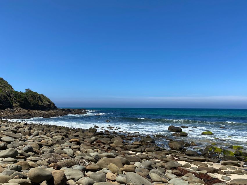
Cape Patton to Skenes Creek Trail Alignment Feasibility Study   World Trail Pty Ltd

1 EXECUTIVE SUMMARY

                                                                                  1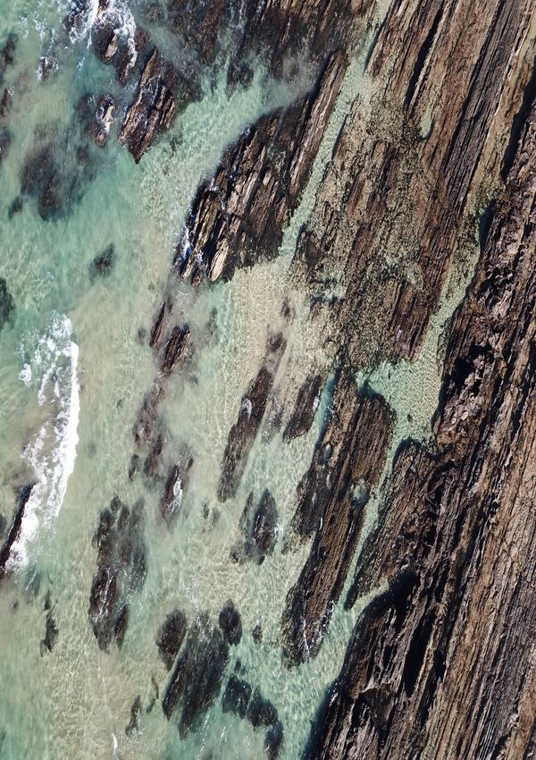
Cape Patton to Skenes Creek Trail Alignment Feasibility Study                                     World Trail Pty Ltd

In 2019, Ernst Young and World Trail were engaged to undertake a Trails Feasibility Study to explore the
potential of a new coastal walking and cycling trail between Fairhaven and Skenes Creek. The Study
considered whether the trail would cater to walkers, cyclists or both (shared-use) and identified a trail
alignment for the preferred concept design that was in four specific sections:
1. Fairhaven to Lorne;
2. Lorne to Wye River;
3. Wye River to Grey River;
4. Grey River to Skenes Creek.

Part of Section 4 (Grey River to Skenes Creek) was identified as presenting significant challenges for trail
construction, due to private land holdings above the Great Ocean Road and very steep profiles on the ocean
side below the road, specifically in the area near Cape Patton. The cost of Section 4 was estimated between
$28.2 million and $50.4 million, with the report stating further investigations would be required from Grey
River to Skenes Creek (approximately 16-20km) to better understand the full range of possible trail
alignment options.

In the second half of 2020, World Trail was engaged by the Department of Environment, Land, Water and
Planning (DELWP) to undertake further investigations for the section of proposed trail between Grey River
and Skenes Creek, in particular the area around Cape Patton.

Following fieldwork and extensive analysis of fieldwork findings, five alternative route options have been
found to be feasible however all have challenges relating to planning and approvals, environmental factors,
visitor risk, capital and operational costs and visitor experience. Further planning and design work will be
required on the preferred option, as part of the process moving forward into the next stage of the overall
project.

One option has been put forward as the recommended route option – trail route option BM, one of the
coastal route options. The recommended route option starts at Kennett River (as it became the logical
starting point) and climbs out of the township on the ridges and spurs looking out over the ocean and then
descends towards the small hamlet of Grey River. At Grey River it crosses the Great Ocean Road to the
coastal side, heading towards Cape Patton, providing an opportunity to experience unique, stunning views
back towards Kennett River and west towards Apollo Bay. It then crosses the Great Ocean Road and heads
up the public road ‘The Rise’. At the top of The Rise, the trail passes through a short distance of private
property to join the existing Carisbrook Falls walking track within the Great Otway National Park. This track
descends to the Carisbrook River, following it back to the car park.

At the Carisbrook Falls car park, the trail crosses the Great Ocean Road to return to the ocean side for a
stretch of almost 2.5km of beach walking. The trail then moves up onto the ocean side verge of the Great
Ocean Road for 3km, to avoid a difficult rock shelf section (pinch points make passing at high tide/swell
almost impossible) and cross Smythe’s Creek. Back on the beach for approximately 1.5km, a wide section of
sand and rock shelf makes for easy walking. The trail then returns close to the road for a short distance
before another short length of beach walking and then passes through a short section of coastal vegetation
with the final section of approximately 850m along the beach to Skenes Creek.

The recommended trail route option is approximately 20.5km in length and would require approximately
12km of new trail construction. The cost estimate for construction is between $2.8 million and $4.2 million.

                                                                           Riders on cold foggy morning in Canberra

                                                                                                                      2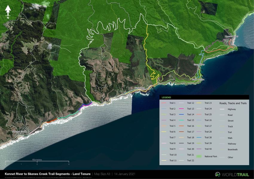
Cape Patton to Skenes Creek Trail Alignment Feasibility Study                                   World Trail Pty Ltd

The main benefits of the recommended trail route option include:
• It avoids an impassable rock shelf section at Cape Patton;
• It connects with Carisbrook Falls;
• The beach walking sections are broken up with other sections, making it a more interesting visitor
    experience;
• It is the second cheapest option;
• It provides a more balanced variety of trail settings and treatments than the other coastal route option.

In contrast, there are some challenges and complexities with the recommended trail route option that will
require further investigation through detailed planning and design. These include:
• There is a 3.5km section that passes through private property. If landholder agreements cannot be
    obtained, this option may become redundant;
• There is a 3km section within the road corridor (broken into two separate sections);
• Overnight accommodation will be required given the length of the trail.

In addition to investigating the feasibility of a trail alignment from Cape Patton to Skenes Creek, World Trail
also identified two opportunities for short loop walks, which add value to the overall Great Ocean Road
Coastal Trail experience, while also being standalone walking experiences of their own.

The first short walk loop option is the Kennett River Loop, approximately 5.5km in length. Starting at the
Kennett River township, the loop follows the existing Kennett River Nature Trail upriver for about 1.5km,
then onto a new section of trail climbing upwards to Grey River Rd. Crossing over Grey River Rd, the loop
returns to Kennett River on the new section of trail that will form part of the Great Ocean Road Coastal Trail.

Establishing this loop trail will provide an opportunity for DELWP / GORCAPA to maintain the excitement and
energy of the Great Ocean Road Coastal Trail as it progresses through further design, planning and
approvals. It will also complement the existing work being undertaken to improve tourism infrastructure in
Kennett River through the Geelong City Deal. Excluding the cost of any segments to be constructed as part of
the Great Ocean Road Coastal Trail, the Kennett River Loop has a construction cost estimate of between
$271,000 and $361,000. Alternatively, if we include the cost of all segments used (for example, under a
scenario whereby this loop trail was constructed before the main Great Ocean Road Coastal Trail), the
Kennett River Loop has a construction cost estimate of between $794,000 and $1,059,630.

The second short walk loop option is the Grey River / Cape Patton Loop, approximately 2.5km. Starting at
the Grey River car park, the loop trail follows a beach access track to the beach, follows the beach south for
approximately 500m. A proposed new section of trail climbs up off the beach and onto a broad flat, elevated
plain at the base of Cape Patton. This plain offers a good opportunity for the development of some type of
lookout infrastructure, with breathtaking views of the rugged coastline to the southwest along the base of
Cape Patton. A new section of trail then climbs up towards the Great Ocean Road, where it connects to
an existing, informal trail, around 900m long, to wind its way through Eucalypt woodlands heading north to
connect into the beach access track and back up to the car park where it started.

Establishing this loop trail will provide an opportunity for DELWP/GORCAPA to maintain the excitement and
energy of the Great Ocean Road Coastal Trail as it progresses through further design, planning and
approvals. It will also provide a unique opportunity for people to experience the views along the coastline
from a unique vantage point near the base of Cape Patton and spot koalas in a safe and more formal
environment. Excluding the cost of any segments to be constructed as part of the Great Ocean Road Coastal
Trail, the cost estimate to construct the Grey River / Cape Patton Loop is between $178,000 and $281,000.
Alternatively, if we include the cost of all segments used (for example, under a scenario whereby this loop
trail was constructed before the main Great Ocean Road Coastal Trail), the Grey River / Cape Patton Loop
has a construction cost estimate of between $265,000 and $399,000.

                                                                                                                  3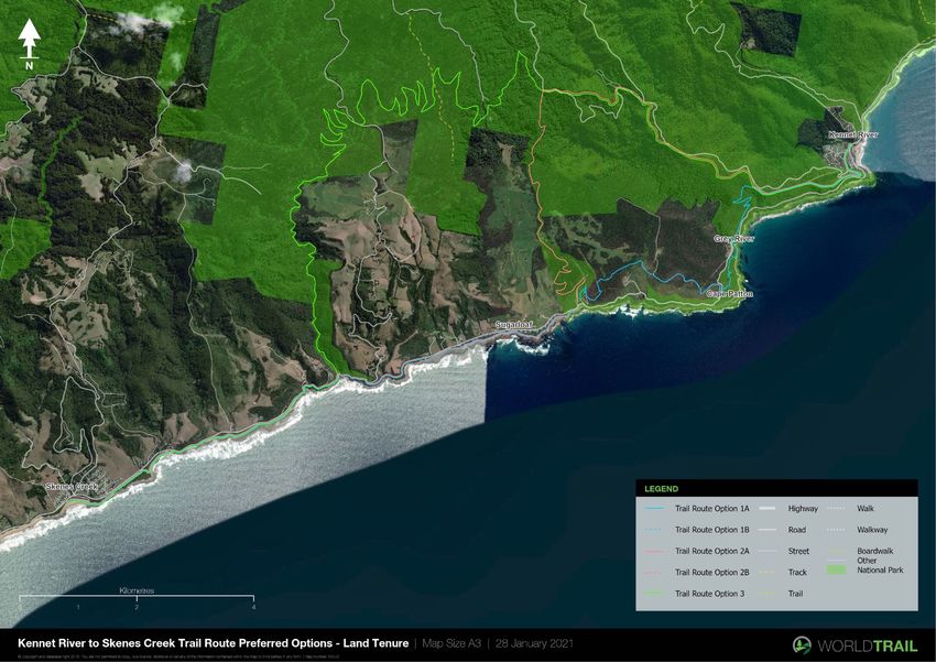
Cape Patton to Skenes Creek Trail Alignment Feasibility Study   World Trail Pty Ltd

2 INTRODUCTION

                                                                                  4
Cape Patton to Skenes Creek Trail Alignment Feasibility Study                                    World Trail Pty Ltd

In 2019, Ernst Young and World Trail were engaged to undertake a Trails Feasibility Study to explore the
potential of a new coastal walking and cycling trail between Fairhaven and Skenes Creek. The aims of the
feasibility study were to:
1. Consider the potential opportunities and challenges associated with trail development;
2. Identify a feasible route and concept designs to connect new sections of trail between Fairhaven and
    Skenes Creek with existing and already planned trails;
3. Estimate construction and ongoing maintenance costs associated with different trail options;
4. Assess the economic benefits and feasibility of trails along the coast.

The Study considered whether the trail would cater to walkers, cyclists or both (shared-use) and identified a
trail alignment for the preferred concept design that was in four specific sections:
5. Fairhaven to Lorne;
6. Lorne to Wye River;
7. Wye River to Grey River;
8. Grey River to Skenes Creek.

A key goal of the project was to develop a trail experience that would provide views and experiences that
could not be had simply by driving along the Great Ocean Road, compelling people to get out of their cars
and into the natural environment and thus spending more time in the region.

Part of Section 4 (Grey River to Skenes Creek) was identified as presenting significant challenges for trail
construction, due to private land holdings above the Great Ocean Road and very steep profiles on the ocean
side below the road, specifically in the area near Cape Patton. The report stated that further investigations
would be required from Grey River to Skenes Creek (approximately 16-20km) to better understand the full
range of possible trail alignment options.

In the second half of 2020, World Trail was engaged by the Department of Environment, Land, Water and
Planning (DELWP) to undertake further investigations for the section of proposed trail between Grey River
and Skenes Creek, in particular the area around Cape Patton.

Map 1 on the following page, taken from the 2019 Trails Feasibility Study, shows the indicative area to be
investigated.

                                                                          Riders on cold foggy morning in Canberra

                                                                                                                     5
Cape Patton to Skenes Creek Trail Alignment Feasibility Study   World Trail Pty Ltd

Map 1. Investigation Study Area - Cape Patton to Skenes Creek

                                                                                  6
Cape Patton to Skenes Creek Trail Alignment Feasibility Study World Trail Pty Ltd
3 PROJECT OBJECTIVES
7Cape Patton to Skenes Creek Trail Alignment Feasibility Study World Trail Pty Ltd
The objectives of this project are to investigate up to five walking trail options and their relative feasibility
between Cape Patton and Skenes Creek and provide a detailed report including maps, trail
recommendations/treatments and estimated construction costs.
Specifically, the report is to include the following:
• Suite of detailed maps showing possible route/type/gaps etc.;
• Options matrix or similar identifying complexity/experience etc.;
• Revised cost estimate for entire section;
• Recommendations for next phases of work to inform further design, geotechnical and planning
considerations and scope.
8Cape Patton to Skenes Creek Trail Alignment Feasibility Study World Trail Pty Ltd
4 DESKTOP REVIEW
9Cape Patton to Skenes Creek Trail Alignment Feasibility Study World Trail Pty Ltd
4.1 FAIRHAVEN TO SKENES CREEK COASTAL TRAIL FEASIBILITY STUDY FINAL REPORT
The ‘Fairhaven to Skenes Creek Coastal Trail Feasibility Study’ was completed in November 2019 for DELWP.
The report presented a high-level conceptual alignment for the trail, broken down into four specific sections:
1. Fairhaven to Lorne;
2. Lorne to Wye River;
3. Wye River to Grey River;
4. Grey River to Skenes Creek.
A key feature of the report was the inclusion of up to five suspension bridges located at strategic points
along the trail. These bridges will span across gullies and valleys, potentially offering views down over the
Great Ocean Road and out to sea.
The trail is proposed to be designed to meet the Australian Walking Track Grading System between Level 2
and 3, meaning that no bushwalking experience is required. The trail may include some steps or a gentle
gradient increasing to short steep sections. The users are expected to be predominately visitors to the Great
Ocean Road region and can be grouped into three potential categories:
1. Those wanting a short walk (1-2 hours, taking in the spectacular suspension bridges and coastal views);
2. Those willing to walk longer distances (3-6 hours) either a loop or from one town to the next;
3. Those wanting longer walks of 3+ days, these visitors would be more self-sufficient bringing a pack and
walk from Fairhaven to Wye River or Kennett River, utilising existing camping grounds, Airbnb or hotel
accommodation on the way through.
Each section of the trail varies in distance and terrain and will be designed to allow visitors of all ages and
abilities an opportunity to experience this unique offering.
The trail will be anchored into the existing towns along the way, thus maximising visitation and spending in
those locations to the benefit of the local economy. It will connect to existing pathways and trails on the
approaches to these towns, maximising the use of existing infrastructure. Some of these existing pathways
are wider and flatter, meeting the requirements of universal access and offering some limited opportunities
for wheelchair access, generally closer to the towns. The more remote sections of the trail will not be
suitable for wheelchair access, having steep gradients, steps and a narrow, uneven surface.
In relation to the section of the trail being investigated in this report, the Ernst Young report identified that it
would require further investigation:
“The route from Grey River to Skenes Creek includes some of the most challenging design and
construction elements in the trail. With private property running along almost the entire inland side
of the Great Ocean Rd, there is no alternative but to place the trail along the verge of the Great
Ocean Rd, down along the coast at sea level, or somewhere in between.
This means that this entire 18km section is likely to be comprised of a mix of different treatments
possibly including:
• Walking trail along the verge/shoulder of Great Ocean Road, with physical barriers to separate
pedestrians from vehicles;
• Conventional trail construction in locations where there is sufficient space between the road and
the coast;
• Beach sections requiring no construction;
• Intertidal rock shelf sections, potentially requiring extensive engineered structures capable of
withstanding high tides and storm surges.
10Cape Patton to Skenes Creek Trail Alignment Feasibility Study World Trail Pty Ltd
Rock revetment works where the Great Ocean Road passes adjacent to the beach with no vegetation
separating the road and the beach. The cost of these revetments used as ‘technical solutions
(extreme)’ in the table below and are based on current works along the Great Ocean Road.
The table below provides a cost estimate based on a mix of different treatments but should be
treated with caution as they are indicative with more investigations required. Without further on-
ground investigations to determine the suitability of the different treatments and further design
advice and refinement, it is difficult to refine these costs further.”
Table 1. Original Cost Estimate for Section 4: Grey River to Skenes Creek
CONSTRUCTION
QUANTITY UNITS RATE - LOW COST RATE - HIGH COST
TREATMENT
Existing Trail
7,810 l/m $0.001 $0.00 $20.00 $156,200.00
Upgrades
New Trail
4,248 l/m $150.00 $637,200.00 $200.00 $849,600.00
Construction
Small Span
32 l/m $800.00 $25,600.00 $1,500.00 $48,000.00
Bridges
Technical
Solutions 3,616 l/m $5,000.002 $18,080,000.00 $8,000.00 $28,928,000.00
(Extreme)
Technical
2,934 l/m $1000.003 $2,934,000.00 $3,000.00 $8,802,000.00
Solutions
Cost Estimate
$21,676,800.00 $38,783,800.00
Range
Contingency
$28,179,840.00 $50,418,940.00
Allowance 30%
Due to the complexity of this section, and the unknowns in terms of the treatments that would be required
to safely construct a trail around the base of Cape Patton, the cost estimate was very high for this section. In
fact, the combined cost estimate for Sections 1 – 3 was approximately $15.9 – 23.6M, lower than the overall
cost for Section 4 alone.
The report presented a number of visitation scenarios, and then used a medium visitation scenario to
undertake a cost benefit analysis. Overall, the project benefits outweighed the costs.
Subsequent to the completion of the report, in late 2020, the Victorian State Government announced that
the project would be funded and would proceed to the next stages of investigation. The funding
announcement included funding for Sections 1 – 3 only, as Section 4 was not deemed to be economically
feasible at that time (based on the route and cost estimate provided in the 2019 Ernst Young report).
1
Some sections are located along the beach, requiring no construction works.
2
The proposed construction treatments around Cape Patton are unknown at this stage - further technical
investigations required. Price based on a sea wall revetment project previously commissioned by DEWLP costing
$1,000,000 for a 3m high structure, 160m in length.
3
The proposed construction treatments along this particular section are unknown at this stage, further technical
investigation required.
11Cape Patton to Skenes Creek Trail Alignment Feasibility Study World Trail Pty Ltd
4.2 PRELIMINARY TRAIL ALIGNMENT OPTIONS
Having been involved in the 2019 project with Ernst Young, World Trail personnel already had a good
familiarity with the area and issues associated with designing a trail around Cape Patton. In considering the
study area at a broad landscape level, the typical landform offers only a handful of distinct settings for a trail
to be constructed. These are referred to as ‘Trail Settings’, and are shown in Figure 1 below.
Figure 1. Indicative Trail Settings
A description of the likely trail alignment options, which are a combination of the trail setting and the
construction treatment, are outlined in the following pages. They may be further defined and refined during
fieldwork as each section of trail is assessed.
12Cape Patton to Skenes Creek Trail Alignment Feasibility Study World Trail Pty Ltd
4.2.1 Trail Alignment Option 1 – Between Beach and Road, Conventional Trail
Conventional trail construction in locations where there is sufficient space between the
edge of the Great Ocean Road and the coast.
Specifically, for this option ‘conventional trail construction’ is defined as trail
DESCRIPTION construction not requiring any significant engineered solutions and ‘the coast is
defined as the high tide mark or edge of vegetation.
Trail surface treatments may include natural surface (i.e. in situ soil), imported gravel,
crushed rock or granitic sand, timber or FRP boardwalk etc.
TRAIL WIDTH Up to 1m wide tread width
FACTORS TO • Primary and secondary dunes – avoid primary dunes;
CONSIDER IN THE • Sideslope;
FIELD • Proximity of trail alignment to Great Ocean Road.
• Relatively low cost;
• Aligns with desired type of walking experience;
ADVANTAGES
• Provides opportunities for variety, based on vegetation, aspect, soils;
• Natural feel.
DISADVANTAGES • Vegetation removal required.
Royal Coast Track, Bundeena
EXAMPLES
Marion Coastal Walking Trail, Adelaide
13Cape Patton to Skenes Creek Trail Alignment Feasibility Study World Trail Pty Ltd
Marion Coastal Walking Trail, Adelaide
Curl Curl to Freshwater Beach Coastal Walk, NSW
14Cape Patton to Skenes Creek Trail Alignment Feasibility Study World Trail Pty Ltd
4.2.2 Trail Alignment Option 2 – Between Beach and Road, Engineered Structure
Engineered structure in locations where there is sufficient space between the edge of
the Great Ocean Road and the coast, but where conventional trail is not possible due
to excessively steep side slope, rocky substrate, or other reasons.
Engineering solutions could include but are not limited to:
DESCRIPTION
• Engineered retaining walls (above or below trail);
• Viewing platforms;
• Hand rails;
• Rock gabions;
• Boardwalks.
Up to 1m wide tread width, although greater width may be required in high visitor
TRAIL WIDTH
traffic areas.
• Sideslope.
FACTORS TO
• Proximity of trail alignment to Great Ocean Road.
CONSIDER IN THE
• Soil/rock stability (visual).
FIELD
• Enables construction in locations where conventional trail is not possible;
ADVANTAGES • Can potentially enable greater no. of visitors;
• Can create a point of difference.
• Vegetation removal required;
DISADVANTAGES • Lesser connection to nature;
• Relatively high cost.
EXAMPLES
Taroona Coastal Path, Hobart, TAS
15Cape Patton to Skenes Creek Trail Alignment Feasibility Study World Trail Pty Ltd
Three Capes Track, TAS
Flagstaff Hill Walking Track, Port Douglas, QLD
Red Arrow Walking Track, Cairns, QLD
16Cape Patton to Skenes Creek Trail Alignment Feasibility Study World Trail Pty Ltd
4.2.3 Trail Alignment Option 3 – Beach or Rock Shelf, No Treatment
Beach and rock shelf sections requiring no trail construction.
DESCRIPTION
The natural environment footprint is used, with walkers navigating their way with
assistance from appropriately designed and located trail markers.
No designated trail width. Dependent on tide and amount of beach/rock shelf available
TRAIL WIDTH
for walking.
• Firmness of the sand;
• Slope on beach;
FACTORS TO
• Rock shelf sections – evenness/un-evenness of rocks;
CONSIDER IN THE
• Impact of high, low and king tides;
FIELD
• Impact of storm swell.
• No/minimal cost;
ADVANTAGES • No/minimal environmental impact;
• Natural feel.
• Can be arduous;
DISADVANTAGES • Can become repetitive;
• Some risks associated with access during high tide.
EXAMPLES
Cape to Cape Track, Western Australia
17Cape Patton to Skenes Creek Trail Alignment Feasibility Study World Trail Pty Ltd
Hakea Trail, Western Australia
Royal Coast Track, Bundeena
18Cape Patton to Skenes Creek Trail Alignment Feasibility Study World Trail Pty Ltd
4.2.4 Trail Alignment Option 4 – Road Corridor
Walking trail along the verge/shoulder of the Great Ocean Road, with physical barriers
to separate pedestrians from vehicles.
Trail could be a conventional natural surface trail, a hardened asphalt or concrete
surface trail, or could require the creation of some type of engineered structure such
DESCRIPTION as a boardwalk if there is insufficient space between road edge and cliff edge.
Note also, that while it is assumed that the outer (lower) shoulder of the road is the
most likely location for a trail, there may be situations where the inside shoulder could
be used.
TRAIL WIDTH Up to 1m wide tread width
• Width of ‘road verge’;
FACTORS TO
• Potential for rockfall;
CONSIDER IN THE
• Width of the road shoulder.
FIELD
ADVANTAGES • Minimal environmental impact.
• Vegetation removal may be required;
• Lesser connection to nature;
• Relatively high cost;
DISADVANTAGES
• Complexity of design;
• Least enjoyable option for trail users;
• Risk of being close to vehicles (partially mitigated by barrier).
EXAMPLES
Sea Cliff Bridge, Wollongong, NSW
19Cape Patton to Skenes Creek Trail Alignment Feasibility Study World Trail Pty Ltd
Coastal Walk, Bondi to Coogee, NSW
Waterfall Gully Track, SA
Typical road/pedestrian separation, WA
20Cape Patton to Skenes Creek Trail Alignment Feasibility Study World Trail Pty Ltd
4.2.5 Trail Alignment Option 5 – Rock Shelf, Engineered Solution
Rock shelf sections of trail requiring engineering structures capable of withstanding
DESCRIPTION
high tides and storm surges.
TRAIL WIDTH 1 – 3m wide tread width
• Height above high-water mark;
FACTORS TO
• Potential for rock fall from above;
CONSIDER IN THE
• Substrate for footings;
FIELD
• Importation of materials during construction phase.
• Big ‘wow’ factor – great user experience;
ADVANTAGES
• Potential opportunity for users to access areas not normally accessible.
• Vegetation removal may be required;
• Lesser connection to nature;
DISADVANTAGES • Likely to be highest cost treatment;
• Complexity of design;
• Some risks associated with access during high tide.
EXAMPLES
Jezzine Barracks, Townsville
21Cape Patton to Skenes Creek Trail Alignment Feasibility Study World Trail Pty Ltd
Jezzine Barracks, Townsville
Royal Coast Track, Bundeena
The Gobbins, Ireland
22Cape Patton to Skenes Creek Trail Alignment Feasibility Study World Trail Pty Ltd
The Gobbins, Ireland
The Gobbins, Ireland
23Cape Patton to Skenes Creek Trail Alignment Feasibility Study World Trail Pty Ltd
4.2.6 Trail Alignment Option 6 – Above Road (Private Property), Conventional Trail
Walking trail along edge of private property on non-coastal side of the Great Ocean
DESCRIPTION
Road. This may require acquisition of private property or lease/licence arrangement.
FACTORS TO • Proximity to cliff edge;
CONSIDER IN THE • Road crossings;
FIELD • Elevation change – potential for steep climbs/descents.
• Potential for great views;
• Opportunity for private sector commercial investment;
ADVANTAGES
• Minimise impacts on coastal areas;
• Provides a change of scenery.
• Vegetation removal may be required;
• Likely to be a high cost treatment (depending on land acquisition strategy);
DISADVANTAGES
• Complexity of obtaining access;
• Requires crossing Great Ocean Road.
The Causeway Coastal Walk, Ireland
EXAMPLES
Great Noosa Trail, Sunshine Coast
24Cape Patton to Skenes Creek Trail Alignment Feasibility Study World Trail Pty Ltd
4.3 DESKTOP ALIGNMENTS
Prior to commencing fieldwork, a desktop review was undertaken of the entire study area, looking at
potential trail alignments and options.
The initial alignment used for the Ernst Young report was based on the premise that the trail should remain
on the ocean side of the Great Ocean Road as much as possible, either on the beach/rock shelf or traversing
the vegetated corridor of land between the road and the beach/rock shelf. This alignment was retained for
further investigation during fieldwork to determine whether it was viable.
In addition to the initial alignment option, three other broad alignment options were identified for further
investigation during fieldwork to determine their viability:
• A route through private property from Cape Patton to Carisbrook Creek and then along the coast to
Skenes Creek;
• An inland route from Kennett River around the northern side of private property, coming down
Carisbrook Creek to the coast and then along the coast to Skenes Creek;
• An inland route from Kennett River around the northern side of private property, coming down Smythes
Creek to the coast and then along the coast to Skenes Creek.
In undertaking the desktop review of potential alignment options, it was decided that the study area should
be broadened slightly to start at Kennett River, rather than Grey River. The main reason for this was simply
that any inland routes would most likely need to depart from the original alignment just after Kennett River,
not even reaching Grey River.
25Cape Patton to Skenes Creek Trail Alignment Feasibility Study World Trail Pty Ltd
5 STAKEHOLDER ENGAGEMENT
26Cape Patton to Skenes Creek Trail Alignment Feasibility Study World Trail Pty Ltd
Key stakeholders were contacted during the desktop review stage to discuss the project and proposed
methodology and provide them with an opportunity to share any knowledge or experience relevant to the
project. Separate on-line teleconference meetings were held with representatives of the following
organisations:
• Colac Otway Shire Council (COS);
• Otway Coast Committee (OCC);
• DELWP.
A brief summary of each meeting is provided in the sections below. It is noted that we did not meet with
Regional Roads Victoria and Parks Victoria at this stage of the project as it was agreed with DELWP that this
would provide greater value at a later stage.
5.1 COLAC OTWAY SHIRE COUNCIL
World Trail met with Frank Castles and Chris Baker on 28 October 2020.
Key points from the discussion included:
• Colac Otway Shire (COS) have been tasked with some key deliverables of the Geelong City Deal, most
notably the Improvements in Infrastructure in Kennett River project and the Apollo Bay (Wild Dog Creek)
to Skenes Creek Walking Track project;
• The walking track between Wild Dog Creek and Skenes Creek will be constructed to all abilities standard;
• COS are finding challenges with the numerous planning and constructions permits that are required for
the approximately 2km walking track;
• In particular, they noted the challenges of planning and constructing a walking track within a narrow
coastal vegetation / dune area;
• COS are supportive and interested in the project being undertaken by World Trail to investigate the
feasibility of a trail alignment between Cape Patton and Skenes Creek.
5.2 DELWP
World Trail met with Michael Noelker and Amber Clarey from DELWP’s Barwon South West Land and Built
Environment Branch on 29 October 2020. Michael and Amber discussed their experience working with the
Marine and Coastal Act 2018 and its subsequent policy and guidelines. These will form a defining role in the
detailed planning for a walking track along the coast.
Key points from the discussion included:
• DELWP are responsible for the implementation of the Marine and Coastal Act 2018, the associated
Coastal Marine Policy 2020 and Siting and Design Guidelines for structures on the Victorian Coast;
• Michael and Amber’s branch support this work, in particular providing advice on Applications for
Consent of Marine and Coastal Crown Land;
• They spoke of the challenges facing the Wild Dog Creek to Skenes Creek walking track project;
• Michael discussed the positives of seeking to engage with Traditional Owners early in project planning;
• Michael and Amber were supportive and interested in the project being undertaken by World Trail to
investigate the feasibility of a trail alignment between Cape Patton and Skenes Creek.
27Cape Patton to Skenes Creek Trail Alignment Feasibility Study World Trail Pty Ltd
5.3 OTWAY COAST COMMITTEE
World Trail met with Anthony Alfirenko, General Manager, Otway Coast Committee on 12 November 2020.
Anthony discussed his experience planning and constructing infrastructure on coastal areas along the Otway
Coast.
Key points from the discussion included:
• Tides and swell can be significant along the Otway coast, which can be challenging for infrastructure
works;
• Maintenance needs to be considered carefully, due to potential weather and climate change impacts;
• There will be many interested organisations and other stakeholders in the project;
• Otway Coast Committee will be incorporated into Great Ocean Road Coastal and Parks Authority
(GORCAPA) from 1 December 2020, which will see some changes in time. It is worth considering if/how
this walking trail alignment may be impacted;
• Anthony was supportive and interested in the project being undertaken by World Trail to investigate the
feasibility of a trail alignment between Cape Patton and Skenes Creek.
28Cape Patton to Skenes Creek Trail Alignment Feasibility Study World Trail Pty Ltd
6 FIELDWORK METHODOLOGY
29Cape Patton to Skenes Creek Trail Alignment Feasibility Study World Trail Pty Ltd
Fieldwork was undertaken in two blocks:
• Monday 2nd – Friday 5th November 2020;
• Wednesday 2nd – Friday 4th December 2020.
The entire coastline from Grey River to Skenes Creek was walked and assessed during these periods. The
assessment of rock shelf sections was scheduled to ensure that they were visited and assessed during high
tide conditions, to determine the degree of inundation and whether it was still feasible to pass safely at high
tide.
The first block of fieldwork coincided with fairly typical high tides of around 1.5m, but calm conditions and
very low swell.
The second block of fieldwork had similar typical high tides of around 1.5m, but a moderately large swell,
allowing a good contrast with the first block of fieldwork and the ability to observe some of the key risk
areas during higher swell conditions.
Any point requiring a particular treatment, representing a significant decision point or visitor risk were
photographed and mapped using GPS.
The inland routes were looked at using existing roads and trails to access the approximate trail alignment,
with the objective of gaining an understanding of the terrain, vegetation and elevation, and thus the overall
feasibility of constructing a trail in those locations. No actual ground-truthing (i.e. the process of determining
and mapping the exact on-ground trail alignment) was conducted.
Where it had been identified that the trail would most likely need to be located on the shoulder/verge of the
Great Ocean Road, video footage was captured of those sections by driving along and filming from the car.
Figure 2 - Figure 10 on the following pages illustrate various aspects of the study site.
30Cape Patton to Skenes Creek Trail Alignment Feasibility Study World Trail Pty Ltd
Figure 2. Calm conditions along Great Ocean Road
Figure 3. Looking east towards Cape Patton from Sugarloaf
31Cape Patton to Skenes Creek Trail Alignment Feasibility Study World Trail Pty Ltd
Figure 4. Impassable section below Cape Patton (on a calm day)
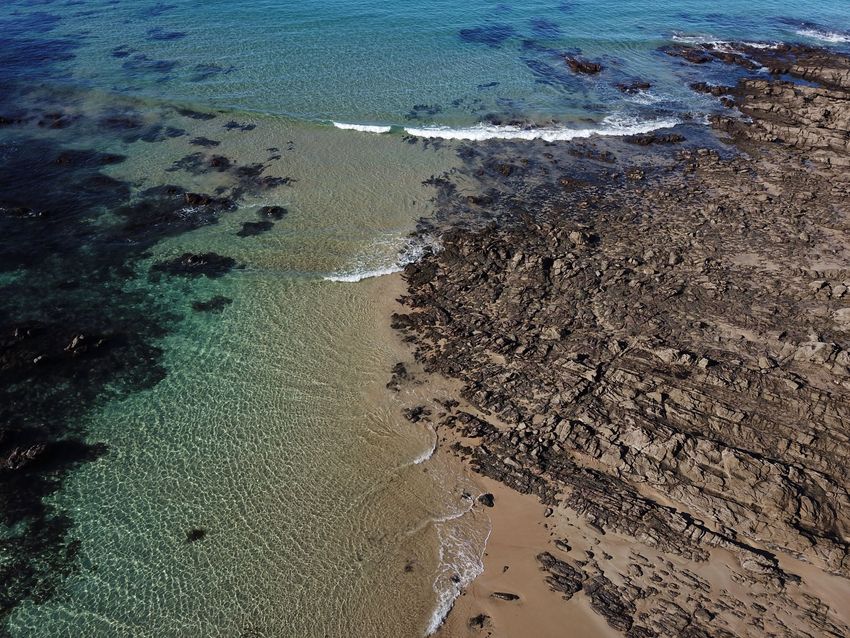
Figure 5. Intertidal rock shelf below Cape Patton
32Cape Patton to Skenes Creek Trail Alignment Feasibility Study World Trail Pty Ltd
Figure 6. Carisbrook Creek outlet to ocean
Figure 7. Looking west towards Carisbrook Creek – note rock/boulder field
33Cape Patton to Skenes Creek Trail Alignment Feasibility Study World Trail Pty Ltd
Figure 8. Broad rock shelves like this are fairly common and ideal walking in good conditions
Figure 9. Rock/boulder strewn beach near Cape Patton
34Cape Patton to Skenes Creek Trail Alignment Feasibility Study World Trail Pty Ltd
Figure 10. View of Carisbrook Falls from viewing platform
35Cape Patton to Skenes Creek Trail Alignment Feasibility Study World Trail Pty Ltd
7 FINDINGS
36Cape Patton to Skenes Creek Trail Alignment Feasibility Study World Trail Pty Ltd
7.1 TRAIL SEGMENTS
Twenty-eight trail segments were created during the fieldwork (see Map 2 on the next page). Trail segments
varied in length from 108m to 19.4km and were each assigned a segment number, trail setting and
treatment (see Table 2). Note that segment numbering is largely sequential (in the east to west direction),
but some segments were identified later and so have segment numbers that are not sequential.
Table 2. Trail Segment Settings and Treatments
TRAIL SEGMENT SETTINGS TRAIL SEGMENT TREATMENTS
Between Beach and Road Conventional Trail
Beach Engineered Structure
Between Beach and Road No Treatment
Road Corridor Other
Above Road (Private Property)
Other
Each segment is defined by their setting, or treatment, or by a branching of route options. For example,
where the setting changes from the beach to the road corridor, a segment would end, and a new segment
would start. Similarly, wherever an alternate alignment option was available, a segment would end, and a
new segment/s would start.
Note that there are three segments shown in the map (38, 39 and 40) that don’t form part of the three main
route options. They were included in our fieldwork as potential additional loop walk options at Kennett River
and Grey River/Cape Patton. These are included in Map 2 for contextual purposes only.
37Cape Patton to Skenes Creek Trail Alignment Feasibility Study World Trail Pty Ltd
Map 2. Kennett River to Skenes Creek Trail Segments
38Cape Patton to Skenes Creek Trail Alignment Feasibility Study World Trail Pty Ltd
Each trail segment was scored to allow relative comparison of the eventual trail route options.
A scoring framework was developed using six criteria:
• Visitor Experience;
• Visitor Risk;
• Capital Cost;
• Operational Cost;
• Environmental Impacts;
• Planning and Approvals.
Each trail segment was given a score from 1 to 5 for each criterion, with higher scores representing the more
attractive option, and lower scores representing less attractive options. Table 3 below provides further detail
of the six criteria and scoring.
Table 3. Trail Segment Scoring Criteria
SCORING INFORMATION
Criteria Score = 1 Score = 5
Visitor Experience Indicates a poor visitor experience Indicates an outstanding visitor
experience
Visitor Risk Indicates high risk for visitors Indicates low risk for visitors
Capital Cost Indicates high capital cost Indicates low capital cost
Operational Cost Indicates high ongoing operational Indicates low ongoing operational
cost cost
Environmental Impacts Indicates high environmental impact Indicates low environmental impact
Planning and Approvals Indicates a complex and challenging Indicates a simple and
planning/approval process straightforward planning/approval
process
A number of assumptions were made during scoring of each trail segment. These are detailed in Table 4
below and should be considered when reviewing the trail segment scoring information in Table 4.
Table 4. Scoring Assumptions
ASSUMPTIONS
1. Where a rock shelf section was impassable or close to impassable at high tide or was deemed to be regularly
inundated by waves, it scored 1 for Visitor Risk.
2. Sections with a considerable length of boulder scrambling or signs of erosion or instability on the cliff above
scored 2 for Visitor Risk.
3. Sections going through a setting of National Park scored lower for Planning and Approvals.
4. Sections of new trail going through coastal vegetation scored 1 or 2 for Planning and Approvals.
5. Beach and Rock Shelf sections that require no treatment scored highest for Operational Cost and Capital Cost.
6. Beach sections generally scored a 2 for Visitor Experience on the basis that they can be hot, have no shade, and
are very exposed.
Each segment was scored using the scoring system and assumptions outlined above. The resulting scores are
shown in Table 5 on the following pages.
39Cape Patton to Skenes Creek Trail Alignment Feasibility Study World Trail Pty Ltd
Table 5. Trail Segments
TRAIL SEGMENTS SCORING
Planning
Segment Length Visitor Operational Environmen Overall
Setting Treatment Notes Visitor Risk Capital Cost and
No. (m) Experience Cost tal Impacts Score
Approvals
Between Beach Conventional From Kennett River up toward Grey River
1. 2679 3.5 3 3 3 3 2 17.5
and Road Trail Road, through Great Otway NP.
From Grey River Road down toward
Conventional
2. 2236 Other Great Ocean Road, mostly through Great 3 3 3 3 3 2 17
Trail
Otway NP.
Majority of trail requires no treatment,
3. 479 Rock Shelf No Treatment but some sections will require significant 2 4 5 5 4 3 23
engineered solution.
Majority of trail requires no treatment,
Engineered
4. 3262 Rock Shelf but some sections will require significant 5 1 1 2 2 1 12
Structure
engineered solution.
5. 409 Beach No Treatment Short section of easy beach walking. 2 4 5 5 4 3 23
6. 1907 Beach No Treatment Section of relatively easy beach walking. 2 4 5 5 4 3 23
Between Beach Conventional Alternative route through vegetation to
7. 539 3 3 3 3 2 1 15
and Road Trail meet existing informal trail
Existing hand-built trail, possibly illegal.
Leading from carpark through grass and
Between Beach Conventional
8. 467 tea tree toward Sugarloaf Creek 3 3 4 3 2 1 16
and Road Trail
(handmade bridge across creek), toward
accommodation across the GOR.
Alternative route through vegetation,
Between Beach Conventional
9. 945 connecting with existing informal trail on 3 3 3 3 2 1 15
and Road Trail
other side of Sugarloaf Creek.
10. 686 Beach No Treatment Short section of easy beach walking. 2 3 4 4 3 3 19
Pinch point will make passing difficult at
Engineered
11. 1883 Rock Shelf high tide/swell. Majority of trail requires 3 1 3 3 2 1 13
Structure
no treatment.
Many locations have sufficient space
behind guardrail for a conventional trail,
12. 1881 Road Corridor Other but some areas will require engineering 2 3 2 2 4 3 16
solutions (e.g., retaining walls) to provide
a wide platform for the trail.
Smythe's Creek toward Skenes Creek,
ending at rock revetment. Mostly
Engineered
13. 1152 Rock Shelf passable at high tide. Majority of trail 3 1 3 3 2 1 13
Structure
requires no treatment, but some sections
will require engineered solution.
40Cape Patton to Skenes Creek Trail Alignment Feasibility Study World Trail Pty Ltd
TRAIL SEGMENTS SCORING
Planning
Segment Length Visitor Operational Environmen Overall
Setting Treatment Notes Visitor Risk Capital Cost and
No. (m) Experience Cost tal Impacts Score
Approvals
Most of this section has sufficient space
Conventional
14. 1229 Road Corridor behind the guardrail, but some areas will 2 3 2 2 4 3 16
Trail
require engineering solutions.
15. 1509 Beach No Treatment Short section of easy beach walking. 2 4 5 5 4 3 23
Beach section. Difficult at high tide due
Engineered
16. 737 Beach to boulders. Engineered solution 2 1 3 3 2 1 12
Structure
required.
Most areas have sufficient space behind
Conventional
17. 753 Road Corridor guardrail, but some areas will require an 2 3 2 2 4 3 16
Trail
engineered solution (e.g. retaining wall).
18. 554 Beach No Treatment Short section of easy beach walking. 2 4 5 5 4 3 23
Majority of trail requires no treatment;
Engineered
19. 887 Rock Shelf some sections will require engineered 3 1 3 3 2 1 13
Structure
solution.
Between Beach Conventional Alternative route through vegetation,
20. 872 3 3 3 3 2 1 15
and Road Trail connecting car park to stairs.
Segment between Kookaburra Cottages
21. 842 Beach No Treatment 2 4 5 5 4 3 23
and Skenes Creek.
Conventional Inland route from Grey River Road and
22. 5164 Other 3.5 3 3 3 3 2 17.5
Trail back down Carisbrook Creek to GOR.
Conventional From junction of trail 2 and trail 4 down
23. 6188 Other 3.5 3 3 3 3 2 17.5
Trail to Carisbrook Creek.
Conventional
24. 19400 Other Inland round through Great Otway NP 4 3 3 3 3 2 18
Trail
Between Beach Conventional
25. 108 Existing beach access trail. 3 3 5 3 4 5 23
and Road Trail
Existing informal trail coming off beach
Between Beach Conventional
26. 863 access track near Grey River, heading up 3 2 3 3 3 3 17
and Road Trail
toward GOR.
Above Road The Rise (public road section), across
Conventional
27. 3493 (Private private land towards Carisbrook Falls 3 3 2 3 3 2 16
Trail
Property) walking track.
Existing trail to Carisbrook Falls lookout.
28. 459 Other No Treatment Old trail appears to continue but has 4 3 4 3 4 4 22
been closed.
41Cape Patton to Skenes Creek Trail Alignment Feasibility Study World Trail Pty Ltd
7.1.1 Other Considerations
The scoring system used above is useful to make relative comparisons of the 28 trail segments, focussing on
six broad criteria. The system can however, ‘hide’ some key considerations that were found to be valuable.
These include:
• Trail length and type of trail and how that would likely impact on the visitor experience. For example,
most people would not enjoy extended sections of beach walking as it can be exposed to the elements,
tiring on legs and can become monotonous. Similarly, extended sections of deep forest can impact on
the visitor experience as it can have less opportunities for longer views, colder/darker, hard going on
legs and become monotonous;
• Any treatment that involves an engineered structure would likely increase the capital cost of
constructing that trail segment significantly. It may also contribute to environmental impacts by the type
of construction methods required and would likely result in significant planning and approvals needing
to be sought. These factors can add complexity to a large project;
• Operational cost was discussed throughout our stakeholder engagement and through our experience in
the trail industry we understand that this is an area often overlooked during trail planning. We believe it
is important to highlight that maintenance of trails in coastal areas can require regular attention due to
tidal events and may incur additional operational costs. This was considered when scoring trail segments
closer to the coast;
• There are a suite of planning components and approvals that will need to be sought to progress the
preferred trail route option. When scoring trail segments, we considered the most notable, high level of
these – e.g., Marine and Coastal Act, National Parks Act, Crown Land Act, engagement with stakeholders
and Traditional Owners.
There are also considerations not included in the scoring system, but worth discussing as they become
important when evaluating trail route options. These include:
• Are there any existing or potential accommodation options available? What is an acceptable distance
(considering trail setting and treatment) to be walked in one day?
• Where a trail segment passes through private property, it will only be a viable option if landholder
agreements can be approved;
• Does the trail route option provide any points of difference when incorporated into the remaining 80km
of Great Ocean Road Coastal Trail?
• The Great Ocean Road Coastal Trail has a goal of being a Class 2/3 walking trail. Will the combination of
trail segments provide for this and maximise the visitor experience?
42Cape Patton to Skenes Creek Trail Alignment Feasibility Study World Trail Pty Ltd
7.2 ROUTE OPTIONS ANALYSIS
With all the trail segments mapped, numbered and scored, the next step was to combine the various
different segments to determine the number of unique route combinations. In total, there were 104 unique
combinations of segments, or routes that could be created. These are shown in Table 6 below with each
unique route option given its own letter designation for identification purposes.
Table 6. Route Options Matrix
ROUTE TRAIL SEGMENT
OPTION 1 2 3 4 5 6 7 8 9 10 11 12 13 14 15 16 17 18 19 20 21 22 23 24 25 26 27 28
COASTAL ROUTE AROUND CAPE PATTON
A
B
C
D
E
F
G
H
I
J
K
L
M
N
O
P
Q
R
S
T
U
V
W
X
Y
Z
AA
AB
AC
AD
AE
AF
COASTAL ROUTE WITH INLAND SECTION UP THE RISE AND DOWN CARISBROOK CREEK
AG
AH
AI
AJ
AK
AL
AM
AN
AO
AP
AQ
AR
AS
AT
AU
AV
AX
AY
AZ
BA
43Cape Patton to Skenes Creek Trail Alignment Feasibility Study World Trail Pty Ltd
ROUTE TRAIL SEGMENT
OPTION 1 2 3 4 5 6 7 8 9 10 11 12 13 14 15 16 17 18 19 20 21 22 23 24 25 26 27 28
BB
BC
BD
BE
BF
BG
BH
BI
BJ
BK
BL
BM
INLAND ROUTE TO CARISBROOK CREEK
BN
BO
BP
BQ
BR
BS
BT
BU
BV
BW
BX
BY
BZ
CA
CB
CC
CD
CE
CF
CG
CH
CI
CJ
CK
CL
CM
CN
CO
CP
CQ
CR
CS
INLAND ROUTE TO SMYTHES CREEK
CT
CU
CV
CW
CX
CY
CZ
DA
44Cape Patton to Skenes Creek Trail Alignment Feasibility Study World Trail Pty Ltd
The next step in the process was to remove any segments that were deemed to have an unacceptable risk
profile, which was defined as any segment that scored a 1 for Visitor Risk. Five segments scored 1 for Visitor
Risk – segments 4, 11, 13, 16 and 19. The rationale behind this decision was that any segment that scored 1
for Visitor Risk is “impassable or close to impassable at high tide or was deemed to be regularly inundated by
waves,” which ultimately means that visitor’s lives could be at risk. This was determined to be an
unacceptable risk, which couldn’t be managed or ameliorated without significant cost and modification to
the natural environment.
Table 7 below shows the 104 route options, but with the five segments that scored 1 for Visitor Risk
highlighted.
Table 7. Route Options Matrix with Segments Ruled Out
ROUTE TRAIL SEGMENT
OPTION
1 2 3 4 5 6 7 8 9 10 11 12 13 14 15 16 17 18 19 20 21 22 23 24 25 26 27 28
COASTAL ROUTE AROUND CAPE PATTON
A
B
C
D
E
F
G
H
I
J
K
L
M
N
O
P
Q
R
S
T
U
V
W
X
Y
Z
AA
AB
AC
AD
AE
AF
COASTAL ROUTE WITH INLAND SECTION UP THE RISE AND DOWN CARISBROOK CREEK
AG
AH
AI
AJ
AK
AL
AM
AN
AO
AP
AQ
AR
AS
AT
AU
45Cape Patton to Skenes Creek Trail Alignment Feasibility Study World Trail Pty Ltd
ROUTE TRAIL SEGMENT
OPTION
1 2 3 4 5 6 7 8 9 10 11 12 13 14 15 16 17 18 19 20 21 22 23 24 25 26 27 28
AV
AX
AY
AZ
BA
BB
BC
BD
BE
BF
BG
BH
BI
BJ
BK
BL
BM
INLAND ROUTE TO CARISBROOK CREEK
BN
BO
BP
BQ
BR
BS
BT
BU
BV
BW
BX
BY
BZ
CA
CB
CC
CD
CE
CF
CG
CH
CI
CJ
CK
CL
CM
CN
CO
CP
CQ
CR
CS
INLAND ROUTE TO SMYTHES CREEK
CT
CU
CV
CW
CX
CY
CZ
DA
46Cape Patton to Skenes Creek Trail Alignment Feasibility Study World Trail Pty Ltd
The result of removing these five segments from the overall route options matrix is stark – only five unique
route combinations remain, as shown in Table 8 below.
Table 8. Preferred Trail Route Options
ROUTE TRAIL SEGMENT
OPTION 1 2 3 4 5 6 7 8 9 10 11 12 13 14 15 16 17 18 19 20 21 22 23 24 25 26 27 28
COASTAL ROUTE WITH INLAND SECTION UP THE RISE AND DOWN CARISBROOK CREEK
BL
BM
INLAND ROUTE TO CARISBROOK CREEK
CR
CS
INLAND ROUTE TO SMYTHES CREEK
DA
Four of the route combinations shown above (BL and BM, CR and CS) have only one difference between
them, being the swap of segment 6 for segments 7,8,9. These segments are described briefly below:
• Segment 6 is a 1.9km section of relatively easy beach walking. It is preceded by segment 5, a 409m
section of easy beach walking and followed by segment 10, a 686m section of easy beach walking;
• Segment 7 is a 539m section of new conventional trail to be constructed between the beach and the
road. It provides (along with segments 8 and 9) an alternative route to segment 6 and is preceded by
segment 5 and followed by segment 8, an existing informal trail;
• Segment 8 is a 467m section of existing informal handbuilt trail that provides (along with segments 7
and 9) an alternative route to segment 6 along the beach. Leading from a roadside carpark, it travels
through grass and teatree toward Sugarloaf Creek where a small makeshift bridge has been constructed.
It is preceded by segment 7 and followed by segment 9;
• Segment 9 is a 945m section of new conventional trail to be constructed between the beach and the
road. It provides (along with segments 7 and 8) an alternative route to segment 6. It is preceded by
segment 8 and followed by segment 10, an 686m section of easy beach walking.
The five preferred trail route options were all scored according to the scoring criteria described previously,
as shown in Table 9 below.
Table 9. Average Scores for Preferred Trail Route Options
TRAIL SEGMENT AVERAGE
ROUTE
SCORE
OPTION 1 2 3 4 5 6 7 8 9 10 11 12 13 14 15 16 17 18 19 20 21 22 23 24 25 26 27 28
COASTAL ROUTE WITH INLAND SECTION UP THE RISE AND DOWN CARISBROOK CREEK
BL 19.3
BM 18.5
INLAND ROUTE TO CARISBROOK CREEK
CR 19.2
CS 18.2
INLAND ROUTE TO SMYTHES CREEK
DA 18.8
The highest scoring trail route option was BL, with 19.3. Trail route option BM is very similar, but swaps
segment 6 (a beach segment) for segments 7,8,9, resulting in a score of 18.5.
The second highest scoring trail route option was CR, with 19.2. Trail route option CS is very similar, but
swaps segment 6 (a beach segment) for segments 7,8,9, resulting in a score of 18.2.
The third highest scoring trail route option was DA, with 18.8.
47You can also read