Bushfire Risk Management Plan - Shire of Jerramungup 2017 2022
←
→
Page content transcription
If your browser does not render page correctly, please read the page content below
Shire of Jerramungup
Bushfire Risk Management Plan

                             2017 – 2022
 Office of Bushfire Risk Management (OBRM) Bushfire Risk Management (BRM) Plan reviewed

                    Local Government Council BRM Plan endorsement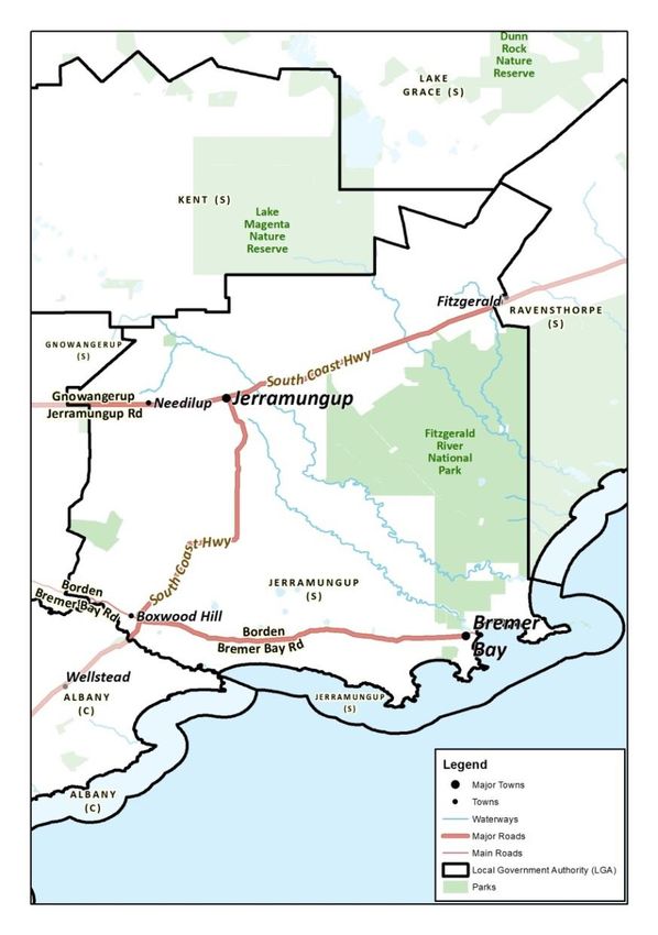
Contents
1. Introduction .................................................................................................................................... 3
1.1 Background ............................................................................................................................. 3
1.2 Aim and Objectives ................................................................................................................. 3
1.3 Legislation, Policy and Standards ............................................................................................ 3
1.3.1 Legislation ....................................................................................................................... 4
1.3.2 Policies, Guidelines and Standards ................................................................................. 4
1.3.3 Other Related Documents .............................................................................................. 5
2. The Risk Management Process ....................................................................................................... 6
2.1 Roles and Responsibilities ....................................................................................................... 6
2.2 Communication & Consultation.............................................................................................. 8
3. Establishing the Context ................................................................................................................. 9
3.1 Description of the Local Government and Community Context ............................................ 9
3.1.1 Strategic and Corporate Framework............................................................................... 9
3.1.2 Location, Boundaries and Tenure ................................................................................. 10
3.1.3 Population and Demographics ...................................................................................... 11
3.1.4 Economic Activities and Industry .................................................................................. 16
3.2 Description of the Environment and Bushfire Context ......................................................... 18
3.2.1 Topography and Landscape Features ........................................................................... 18
3.2.2 Climate and Bushfire Season ........................................................................................ 19
3.2.3 Vegetation ..................................................................................................................... 22
3.2.4 Bushfire Frequency and Causes of Ignition................................................................... 27
4. Asset Identification and Risk Assessment ..................................................................................... 29
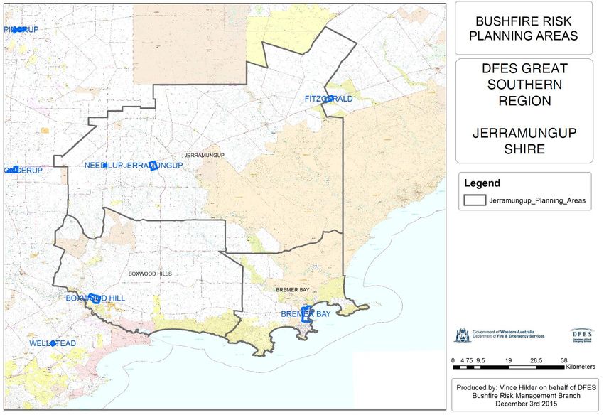
4.1 Planning Areas ...................................................................................................................... 29
4.1.1 Priorities for Asset Identification and Assessment ....................................................... 29
4.2 Asset Identification ............................................................................................................... 29
4.3 Assessment of Bushfire Risk ................................................................................................. 31
4.3.1 Likelihood Assessment .................................................................................................. 31
4.3.2 Consequence Assessment ............................................................................................. 31
4.3.3 Assessment of Environmental Assets ........................................................................... 34
4.3.4 Local Government Asset Risk Summary........................................................................ 34
5. Risk Evaluation .............................................................................................................................. 35
5.1 Evaluating Bushfire risk ......................................................................................................... 35
5.2 Treatment Priorities .............................................................................................................. 35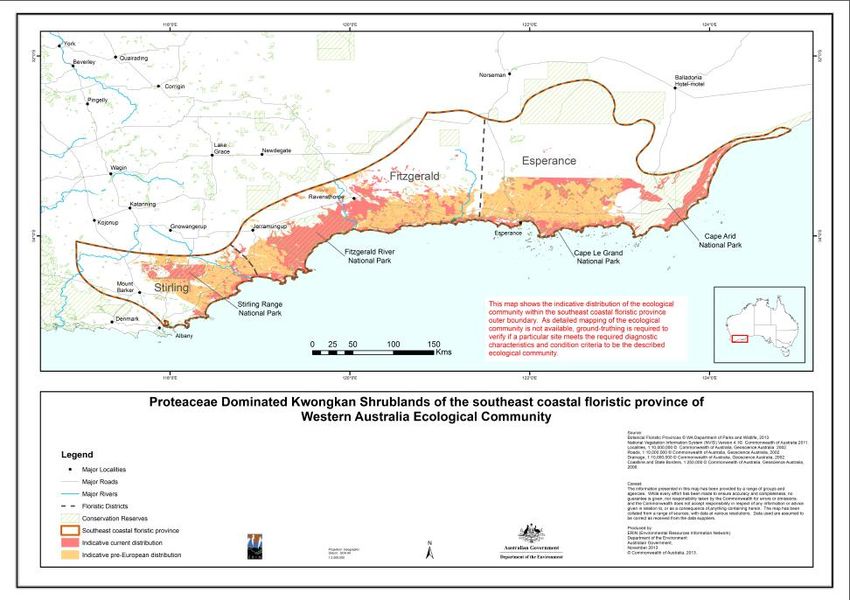
5.3      Risk Acceptability .................................................................................................................. 35
6.     Risk Treatment .............................................................................................................................. 37
     6.1      Local Government-Wide Controls......................................................................................... 37
     6.2      Asset-Specific Treatment Strategies ..................................................................................... 37
     6.3      Determining the Treatment Schedule .................................................................................. 38
7.     Monitoring and Review................................................................................................................. 39
     7.1      Review ................................................................................................................................... 39
     7.2      Monitoring ............................................................................................................................ 39
     7.3      Reporting............................................................................................................................... 39
8.     Glossary ......................................................................................................................................... 40
9.     Common Abbreviations ................................................................................................................ 44
APPENDIX 1 – Communication Strategy ............................................................................................... 46
APPENDIX 2 – Planning Area Map......................................................................................................... 56
APPENDIX 3 – Local Government-Wide Controls, Multi-Agency Treatment Work Plan ...................... 57
APPENDIX 4 – Map of Kwongkan Shrublands ....................................................................................... 65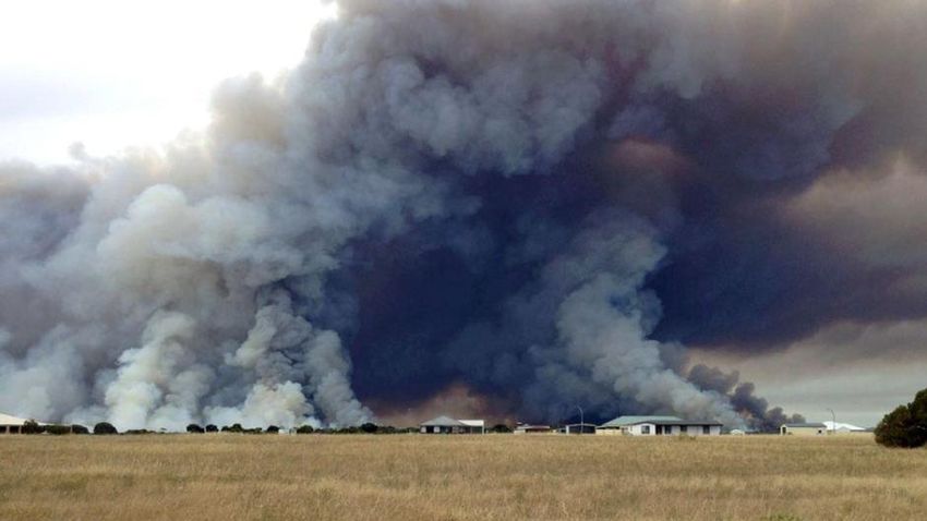
Document Control
Document Name           Bushfire Risk                 Current Version           2.0
                        Management Plan               Adoption Reference        OC170611
Document Owner          Shire of Jerramungup          Issue Date                09/06/2017
                        CEO
Document Location       NPP176                        Next Review Date          09/06/2022

Document Endorsements
Shire of Jerramungup Council endorses that the Bushfire Risk Management Plan (BRM Plan) has been
reviewed and assessed by the Office of Bushfire Risk Management as compliant with the standard for
bushfire risk management planning in Western Australia, the Guidelines for Preparing a Bushfire Risk
Management Plan. Shire of Jerramungup is the owner of this document and has responsibility, as far
as is reasonable, to manage the implementation of the BRM Plan (subject to resource availability) and
facilitate the implementation of bushfire risk management treatments by risk owners. The
endorsement of the BRM Plan by Shire of Jerramungup Council satisfies their endorsement obligations
under section 2.3.1 of the State Hazard Plan for Fire (Westplan Fire).

Note: In approving the BRM Plan, the local government council is acknowledging the assets that have
been identified and the risk ratings and treatment priorities assigned. Approval of the plan is a
commitment by local government to work with land owners and managers to address unacceptable
risk within their community. It is not the local government committing to a program of treatment
works to be implemented by others or an acceptance of responsibility for risk occurring on land that is
not owned or managed by the local government1.

Local Government           Representative             Signature                   Date
Shire of Jerramungup       Shire of Jerramungup                                   21 June 2017
                           CEO – Brent Bailey

Amendment List

Version                    Date                       Author                      Section

1.0                        15 May 2017                Vivienne Gardiner           Version 1.0 submitted
                                                      Vince Hilder                to OBRM for review
2.0                        9 June 2017                Vivienne Gardiner           Version 2.0 submitted
                                                      Melanie Haymont             to OBRM for review

1
 Government of Western Australia Office of Bushfire Risk Management (2015), Guidelines for Preparing a
Bushfire Risk Management Plan, pp. 79

Shire of Jerramungup Bushfire Risk Management Plan 2017 – 2022    DRAFT                          Page 1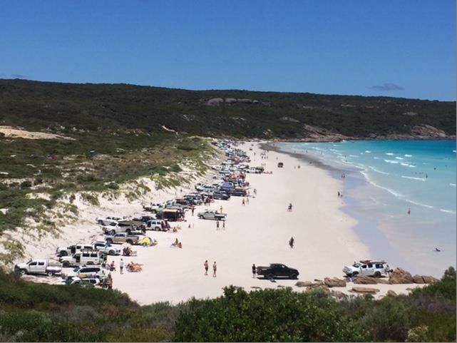
Publication Information
Wherever a third party holds copyright in material presented in this publication, the copyright remains
with that party. Their permission may be required to use the material.

This document contains Standards Australia Ltd and ISO copyrighted material that is distributed by SAI
Global on Standards Australia Ltd and ISO’s behalf. It may be reproduced in accordance with the
terms of SAI Global Ltd.’s Licence 1411-c083 to the Commonwealth of Australia (“the Licensee”). All
licensed copies of this document must be obtained from the Licensee. Standards Australia Ltd and
ISO’s material is not for resale, reproduction or distribution in whole or in part without written
permission from SAI Global Ltd: tel + 61 2 8206 6355 or copyright@saiglobal.com.

Shire of Jerramungup Bushfire Risk Management Plan 2017 – 2022   DRAFT                     Page 2
1. Introduction
1.1 Background
Under the State Hazard Plan for Fire (Westplan Fire) an integrated Bushfire Risk Management Plan
(BRM Plan) is to be developed for local government areas with significant bushfire risk. This BRM Plan
has been prepared for the Shire of Jerramungup in accordance with the requirements of Westplan Fire
and the Guidelines for Preparing a Bushfire Risk Management Plan (Guidelines). The risk management
processes used to develop this BRM Plan are aligned to the key principles of AS/NZS ISO 31000:2009
Risk management – Principles and guidelines (AS/NZS ISO 31000:2009), as described in the Second
Edition of the National Emergency Risk Assessment Guidelines (NERAG 2015). This approach is
consistent with the policies of the State Emergency Management Committee, specifically the State
Emergency Management Policy 3.2 – Emergency Risk Management Planning.
This BRM Plan is a strategic document that identifies assets at risk from bushfire and their priority for
treatment. The Treatment Schedule sets out a broad program of coordinated multi-agency
treatments to address risks identified in the BRM Plan. Government agencies and other land
managers responsible for implementing treatments participate in developing the BRM Plan to ensure
treatment strategies are collaborative and efficient, regardless of land tenure.
1.2 Aim and Objectives
The aim of the BRM Plan is to document a coordinated and efficient approach toward the
identification, assessment and treatment of assets exposed to bushfire risk within the Shire of
Jerramungup.
The objective of the BRM Plan is to effectively manage bushfire risk within the Shire of Jerramungup in
order to protect people, assets and other things of local value. Specifically, the objectives of this BRM
Plan are to:
Guide and coordinate a tenure blind, multi-agency bushfire risk management program
over a five year period;
Document the process used to identify, analyse and evaluate risk, determine priorities and
develop a plan to systematically treat risk;
Facilitate the effective use of the financial and physical resources available for bushfire risk
management activities;
Integrate bushfire risk management into the business processes of local government, land
owners and other agencies;
Ensure there is integration between land owners and bushfire risk management programs
and activities;
Monitor and review the implementation of treatments to ensure treatment plans are
adaptable and risk is managed at an acceptable level.
1.3 Legislation, Policy and Standards
The following legislation, policy and standards were considered to be applicable in the development
and implementation of the BRM Plan.
Shire of Jerramungup Bushfire Risk Management Plan 2017 – 2022 DRAFT Page 3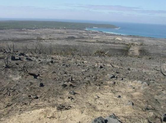
1.3.1 Legislation
Bush Fires Act 1954
Emergency Management Act 2005
Fire Brigades Act 1942
Fire and Emergency Service Act 1998
Conservation and Land Management Act 1984
Environmental Protection Act 1986
Environmental Protection and Biodiversity Conservation Act 1999
Wildlife Conservation Act 1950
Aboriginal Heritage Act 1972
Metropolitan Water Supply, Sewerage and Drainage Act 1909
Country Areas Water Supply Act 1947
Building Act 2011
Bush Fires Regulations 1954
Emergency Management Regulations 2006
Planning and Development (Local Planning Scheme) Regulations 2015
National Trust of Australia (WA) Act 1964
Soil and Land Conservation Act 1945
Building Act 2011
1.3.2 Policies, Guidelines and Standards
National Emergency Risk Assessment Guidelines (NERAG) (Second Edition 2015)
State Emergency Management Policy 2.5 - Emergency Management in Local Government
Districts
State Emergency Management Policy 3.2 – Emergency Risk Management Planning
State Hazard Plan for Fire (Westplan Fire)
State Planning Policy 3.7: Planning in Bushfire Prone Areas
State Planning Policy 3.4: Natural Hazards and Disasters
Guidelines for Planning in Bushfire Prone Areas (2015)
Western Australian Emergency Risk Management Guidelines (Emergency Management WA
2005)
A Guide to the Use of Pesticides in Western Australia (Dept. of Health 2010)
Guidelines for Plantation Fire Protection (DFES 2011)
Firebreak Location, Construction and Maintenance Guidelines (DFES)
Bushfire Risk Management Planning – Guidelines for preparing a Bushfire Risk
Management Plan (2015)
AS/NZS ISO 31000:2009 - Risk management – Principles and guidelines
AS 3959-2009 Construction of buildings in bushfire-prone areas
Building Protection Zone Standards (DFES)
Shire of Jerramungup Fire Control Policy 4. - Harvest Bans
Shire of Jerramungup Fire Control Policy 2. – Bush Fires on Crown Land
Shire of Jerramungup – Fire Control Information (Bush Fires Act 1954 – Section 33(1))
Shire of Jerramungup Local Planning Policy (LPP) No. 3 Design Guidelines &detailed Area
Plan ,Lot 231 Bremer Bay Rd 2015
Shire of Jerramungup Bushfire Risk Management Plan 2017 – 2022 DRAFT Page 4
Shire of Jerramungup Local Planning Policy (LPP) No. 10 - Agroforestry and Plantations
(2015)
Shire of Jerramungup Local Planning Policy (LPP) No. 12 - Requirement for Fire
Management Plans (2015)
Shire of Jerramungup Local Planning Policy (LPP) No. 18 - Point Henry Fire Management
(2015)
Shire of Jerramungup Local Planning Policy (LPP) No. 19 - Bremer Bay Town Centre Design
Guidelines (2015)
Code of Practice for Timber Plantations in Western Australia – Forest Industries Federation
(WA) inc. Australian Forest Growers (AFG) Forest Products Commission, The Government of
Western Australia.
1.3.3 Other Related Documents
National Strategy for Disaster Resilience
National Statement of Capability for Fire and Emergency Services (AFAC 2015)
Public Service Circular No. 88 Use of Herbicides in Water Catchment Areas (Dept. of Health
2007)
Code of Practice for Timber Plantations in Western Australia (Forest Products Commission
2006)
Bushfire Risk Management Planning Handbook
Bushfire Risk Management System (BRMS) User Guide
Shire of Jerramungup - Community Plan 2016-2026
Shire of Jerramungup - Bremer Bay Structure Plan Report 2015-02-24
Shire of Jerramungup - Corporate Business Plan 2014/15 to 2017/18
Shire of Jerramungup - Local Planning Strategy (2012)
Shire of Jerramungup – Emergency Management Recovery Plan
Shire of Jerramungup - Local Emergency Management Arrangements
Shire of Jerramungup Annual Fire Break Notice
Shire of Jerramungup Fire Zones
Municipal inventory of Heritage places
Shire of Jerramungup Bremer Bay Fire Break Plan
DER Permit to clear
State Emergency Management Committee – Great Southern District Risk Assessment
Summary Risk Results Report.
Guidelines for Plantation Fire Protection – Fire and Emergency Services Authority
Shire of Jerramungup Bushfire Risk Management Plan 2017 – 2022 DRAFT Page 5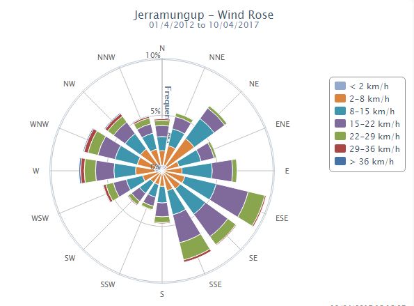
2. The Risk Management Process
The risk management processes used to identify and address risk in this BRM Plan are aligned with the
international standard for risk management, AS/NZS ISO 31000:2009, as described in NERAG (2015).
This process is outlined in Figure 1 below.
Establish the context
Risk Assessment
Communication & consultation
Risk Identification
Monitoring & review
Risk Analysis
Risk Evaluation
Risk Treatment
2
Figure 1 - An overview of the risk management process
2.1 Roles and Responsibilities
Table 1 – Roles and Responsibilities
Stakeholder Name Roles and Responsibilities
Local Government As custodian of the BRM Plan, coordination of the development and
ongoing review of the integrated BRM Plan.
Negotiation of commitment from land owners to treat risks identified in
the BRM Plan.
As treatment manager, implementation of treatment strategies.
As part of the approval process, submission of the draft BRM Plan to the
Office of Bushfire Risk Management (OBRM) to review it for consistency
with the Guidelines.
As part of the approval process, submission of the final BRM Plan to
council for their endorsement and adoption.
Department of Fire Participation in and contribution to the development and
and Emergency implementation of BRM Plans, as per their agency responsibilities as the
Services (DFES) Westplan Fire Hazard Management Agency.
Support to local government through expert knowledge and advice in
relation to the identification, prevention and treatment of bushfire risk.
Facilitation of local government engagement with state and federal
government agencies in the local planning process.
2
Source: AS/NZS ISO 31000:2009, Figure 1, reproduced under SAI Global copyright Licence 1411-c083.
Shire of Jerramungup Bushfire Risk Management Plan 2017 – 2022 DRAFT Page 6Stakeholder Name Roles and Responsibilities
Undertake treatment strategies, including prescribed burning on behalf
of Department of Lands for Unmanaged Reserves and unallocated crown
land within gazetted town site boundaries.
In accordance with Memorandums of Understanding and other
agreements, implementation of treatment strategies for other
landholders.
Office of Bushfire Under the OBRM Charter, to ensure bushfire risk is managed in
Risk Management accordance with AS/NZS ISO 31000 and reporting on the state of
(OBRM) bushfire risk across Western Australia.
Review BRM Plans for consistency with the Guidelines prior to final
endorsement by council.
Department of Parks Participation in and contribution to the development and
and Wildlife (P&W) implementation of BRM Plans.
Providing advice for the identification of environmental assets that are
vulnerable to fire and planning appropriate treatment strategies for their
protection.
As treatment manager, implementation of treatment strategies on
department managed land and for Unmanaged Reserves and
unallocated crown land outside gazetted town site boundaries.
In accordance with Memorandums of Understanding and other
agreements, implementation of treatment strategies for other
landholders.
Other State and Assist the local government by providing information about their assets
Federal Government and current risk treatment programs.
Agencies Participation in and contribution to the development and
implementation of BRM Plans.
As treatment manager, implementation of treatment strategies.
Public Utilities Assist the local government by providing information about their assets
and current risk treatment programs.
Participation in and contribution to the development and
implementation of BRM Plans.
As treatment manager, implementation of treatment strategies.
Corporations and As treatment manager, implementation of treatment strategies.
Private Land Owners
Others Participation in and contribution to the development and
Chief Bushfire implementation of BRM Plans and treatment schedules.
Control Officer Providing advice for the identification of assets that are vulnerable to fire
Bushfire Providing advice on appropriate treatment strategies for asset
Advisory protection.
Committee
District
Operations
Advisory
Committee
Local Emergency
Management
Shire of Jerramungup Bushfire Risk Management Plan 2017 – 2022 DRAFT Page 7Stakeholder Name Roles and Responsibilities
Committee
Bushfire
Brigades and
other Emergency
Services
2.2 Communication & Consultation
As indicated in Figure 1, communication and consultation throughout the risk management process is
fundamental to the preparation of an effective BRM Plan. To ensure appropriate and effective
communication occurred with relevant stakeholders in the development of the BRM Plan, a
Communication Strategy was prepared. The strategy is provided at Appendix 1.
Shire of Jerramungup Bushfire Risk Management Plan 2017 – 2022 DRAFT Page 83. Establishing the Context 3.1 Description of the Local Government and Community Context 3.1.1 Strategic and Corporate Framework The Shire of Jerramungup’s strategic and corporate framework is outlined in the recently adopted Community Strategic Plan 2016-20263. The Plan outlines the Shire’s strategic direction and highlights priority areas for the next 10 years. The plan establishes a vision for the local government’s future and its aspirations and service expectations. It drives the development of local government area, place, regional and resourcing plans such as workforce plans, asset management plans and other informing strategies. The following aspirations and objectives are taken from this plan as they relate specifically to bushfire risk management: Environment: The key aspirations within this area reflect the Shire’s location and proximity to the Fitzgerald River National Park (FRNP). The Shire’s location is recognized internationally for its biodiversity, pristine coastal environmental and human interaction with the landscape. Land use planning, land capability and natural resource management are addressed in this area. Aspiration 1.1 - Environmental Stewardship - To be an industry leader in implementing new technology and initiatives which deliver environmental benefits to the region, includes Objective 1.1.2 – Continue the delivery of fire mitigation strategies across the Shire. The Shire recognises the Department of Fire and Emergency Services and the Department of Parks and Wildlife (P&W) as key agency partners in achieving this objective. Aspiration 2.4 - Emergency Management and Climate Change - To ensure that the Shire of Jerramungup is well prepared and resourced to mitigate the impacts of natural disasters and climate change. Within which is Objective 2.4.1: Maintain a high standard of emergency planning and preparedness, demonstrates the Shires ongoing commitment to emergency management and in particular objective 2.4.4 - Continue the delivery of fire mitigation strategies across the Shire. Further to this overarching strategic framework the Shire of Jerramungup, in accordance with Section 38 of the Emergency Management Act 2005, has established a Local Emergency Management Committee (LEMC). The LEMC has multiagency membership and provides an important multiagency forum for the BRM Plan to consult. The LEMC provides support within the respective agencies, strategic oversight and review for the project. The Shire of Jerramungup Bush Fire Advisory Committee (BFAC) has played an integral role in the development of the BRM Plan, in particular review and input, existing controls and the identification of assets, assessment of risk and the development of treatment options. The LEMC and the BFAC will continue to have involvement in the implementation and review of the BRM Plan as outlined in Appendix 1 – Communication Strategy. 3 Shire of Jerramungup (20015), Community Strategic Plan downloaded on 3 May 2016 from www.jerramungup.wa.gov.au Shire of Jerramungup Bushfire Risk Management Plan 2017 – 2022 DRAFT Page 9
3.1.2 Location, Boundaries and Tenure
The Shire of Jerramungup was established on 1 July 1982. It is located in the Great Southern region of
Western Australia, about 180 kilometres northeast of Albany and about 440 kilometres southeast of
Perth4. The Shire covers an area of 6,507 square kilometres.

                                                                                   5
                               Figure 2 – Shire of Jerramungup Regional Location

The Shire of Jerramungup is bordered by the Shires of Gnowangerup to the west, Kent to the north,
Ravensthorpe to the east, Lake Grace on the north-east corner, the City of Albany to the south-west
and the Southern Ocean to the south. The Shire incorporates the towns of Jerramungup and Bremer
Bay and the districts of Needilup, Jacup, Gairdner, Boxwood Hill and Fitzgerald. Jerramungup and
Bremer Bay and the two main town sites the others have not developed in any significant way.

4
  Shire of Jerramungup (20015), Community Strategic Plan downloaded on 3 May 2016 from
www.jerramungup.wa.gov.au
5
  Source: Department of Fire and Emergency Services

Shire of Jerramungup Bushfire Risk Management Plan 2017 – 2022       DRAFT                Page 10
Table 2 – Overview of Land Tenure and Management within the BRM Plan Area
Land Manager/Agency* % of Plan Area
Local Government 6.6%
Private 69.2%
Department of Parks and Wildlife 21%
Department of Lands 3.2%
Total 100%
Source: DFES and Shire of Jerramungup
The Jerramungup town site is located on National Highway One, which links Albany and Esperance,
and lies at a road junction of the major Esperance-Perth route. It is the administrative centre for the
area.
Bremer Bay is the other significant town site in the district. The town is approximately 100 kilometres
southeast of Jerramungup on the coast and encompasses 1,200 hectares extending from the
Wellstead Estuary in the north to Fishery Beach in the south. Bremer Bay is best known for fishing,
tourism and agriculture.
The region is recognised by Noongar people as Wagyl Kaip6. There are many cultural and significant
sites in the Wagyl Kaip and Southern Noongar region, many of which are in the Shire of Jerramungup.
The Wagyl Kaip and Southern Noongar claim for Native Title was made in September 2006. Indigenous
Land Use Agreements have commenced operation since, however the Southwest Native Title
Settlement will not commence until after registration of the ILUAs by the Native Title Registrar and the
resolution of any court proceedings7.
3.1.3 Population and Demographics
The most recent Australian Bureau of Statistics (ABS) data shows the population in the Shire of
Jerramungup in 2014 as 1,077, of which 575 were male and 502 female with a median age of 39.9. The
population density is 0.2 people per square kilometre.8
The Shire of Jerramungup is characterised by a large land area and a small population clustered into
two main centers, Jerramungup and Bremer Bay. According to the ABS 2011 the, Jerramungup town
site had a population of 269, and Bremer Bay 2099.
The remainder of the Shire is sparsely populated with a significant proportion of the land area in
Crown Reserves outside the management and responsibility of the Shire of Jerramungup.
6
http://www.noongarculture.org.au/wagyl-kaip/
7
http://www.noongar.org.au/new-page-17/
8
Australian Bureau of Statistics, Regional Summary Jerramungup LGA downloaded 6 April 2017 from
http://stat.abs.gov.au
9
Australian Bureau of Statistics, Regional Summary Jerramungup LGA downloaded 6 April 2017 from
9
http://stat.abs.gov.au Shire of Jerramungup Strategic Community Plan 2012-24 downloaded 8 June 2017 from
http://jerramungup.wa.gov.au/community/
Shire of Jerramungup Bushfire Risk Management Plan 2017 – 2022 DRAFT Page 11The Shire, in its Strategic Community Plan 2012-25 identified the following as some of the trends characterising its local government area; decreasing population, increasing median age, increasing median personal and family income, decreasing rates of volunteerism and increasing visitation rates10. It is worth noting however that the Western Australian Planning Commission (WAPC) and ABS in the Shire Jerramungup Local Planning Strategy, 2012 recognised several local variations not reflected in the population figures. Of these most notably is the pressure caused by service populations such as tourists and seasonal workforces. It is estimated the population of Bremer Bay includes approximately 6,000 tourists annually. Bremer Bay also has a high level of absentee owners who do not occupy houses for the full year. 11 This transient population presents a number of challenges for bushfire risk management as discussed later in this plan. The ABS has estimated a static population for the Shire of Jerramungup for the period extending to 2021. This may change as a result of new or emerging industries. While there are currently no immediate prospects for new or emerging industries there is a mining lease near Wellstead that has the potential to be developed and attract a labour workforce of several hundred people to Bremer Bay. The increase in the retiree population is expected to be slow for at least the next 5 to 10 years. However as much of the agricultural land within the Shire and neighbouring local governments was taken up in the 1960s and 1970s by people in their 30s and 40s, this population is expected to relocate to the coast within the next 5 - 15 years. 12 There has been development pressure on the Shire to create new residential and rural residential areas. A review of the Local Planning Strategy will assist in identifying appropriate areas for future development and expansion. The existing rural residential area at Point Henry has been largely developed, does not cater for aged population needs, and is mainly limited to bush lots. This subdivision is recognised as being a significant risk of bushfire. Following a serious bushfire in 2012 the Shire of Jerramungup developed Local Planning Policy (LPP) No. 18 - Point Henry Fire Management (2015). The town of Jerramungup is the main administration centre for the surrounding agricultural area13. It is surrounded on two sides by uncleared reserves. The reserves provide an important visual barrier, however the bushfire risk needs to be balanced against the need for visual amenity. Bremer Bay has a reasonably constrained townsite with a rural subdivision set in an area of high bushfire risk to the south on Point Henry Peninsula. The town itself is located on the Wellstead Estuary and is surrounded by large areas of uncleared vegetation to the north and east. The extensive area of uncleared vegetation surrounding the community is located within unallocated crown land (UCL) and the FRNP. As it poses a significant bushfire risk to the community the risk needs to be managed. 10 Shire of Jerramungup Strategic Community Plan 2012-24 downloaded 8 June 2017 from http://jerramungup.wa.gov.au/community/ 11 Shire Jerramungup (2012), Local Planning Strategy, downloaded 5 May 2016 from https://www.planning.wa.gov.au 12 Shire Jerramungup (2012), Local Planning Strategy, downloaded 5 May 2016 from https://www.planning.wa.gov.au 13 Shire Jerramungup (2012), Local Planning Strategy, downloaded 5 May 2016 from https://www.planning.wa.gov.au Shire of Jerramungup Bushfire Risk Management Plan 2017 – 2022 DRAFT Page 12
The town is at its most vulnerable to bushfire in summer during the peak tourist season when the
transient populations swells. The town has a single road access and is constrained by the coast and
Estuary. In early December 2012 the entire town was evacuated when a bushfire threatened the
community from the west. The entire rural subdivision of Point Henry was burnt in 2002 by a fast
moving fire that reached the edge of the main town site14.

                                                                                                15
                      Figure 3 – Bushfire in the UCL adjacent to the Bremer Bay townsite 2012

The existing residential areas of the town are well established and there are some limited areas
available for expansion. Currently there are no larger lifestyle lots in the town. The existing
commercial centre comprises a range of services including rural agencies, machinery dealership,
depot, and hardware store16.

Bremer Bay has approximately 270 dwellings in the town, with about one third currently occupied on
a permanent basis, and the rest on a seasonal or semi-permanent basis. The maximum residential
population is approximately 650, based on the existing number of dwellings. Forty seven building
licences were issued by the Shire between 2007 and 2009 resulting in an average increase of 15
dwellings per year in Bremer Bay14.

Bremer has a rural residential area on Point Henry Peninsula that has a significant bushfire risk. There
are an estimated 207 freehold properties with approximately 80 of these developed17.

14
   Shire Jerramungup (2012), Local Planning Strategy, downloaded 5 May 2016 from
https://www.planning.wa.gov.au
15
   ABC http://www.abc.net.au/news/2012-12-04
16
   Shire Jerramungup (2012), Local Planning Strategy, downloaded 5 May 2016 from
https://www.planning.wa.gov.au
17
   Shire of Jerramungup (2015), Local Planning Policy No 18 - Point Henry Fire Management

Shire of Jerramungup Bushfire Risk Management Plan 2017 – 2022          DRAFT                        Page 13
18
Figure 4 – Visitors, New Year’s day, Blossoms Beach, Point Henry Peninsula Bremer Bay
During the summer months it is estimated the population of the town increases significantly. This
includes people camping in the UCL, Doubtful Island, Point Ann in the Fitzgerald National Park, Point
Henry, Dillon Bay and general coastal areas. The transient tourist population in Doubtful Island UCL is
considered a significant enough risk that the Local Emergency Management Committee has developed
a specific evacuation plan for this area. The Shires Local Emergency Management Arrangements gives
special consideration to this transient population19.
Boxwood Hill is a largely undeveloped town site however has some community and recreational
facilities. The combined convenience store/service station provides for local convenience needs and
has a dual function as it services visitors requiring petrol and a stopover for refreshments.
Recreational facilities are available at the golf course/country club20.
Needilup town site includes a small group of residential lots with a church site, town hall, golf course,
and a small park. This area remains largely undeveloped.
At Gairdner, there is most significantly a bulk grain terminal which receives grain during the early
summer harvest period. Adjacent to this is a school, hall, oval, tennis courts, ambulance depot, and 2
houses.
18
Source: Shire of Jerramungup, Melanie Haymont, 1 January 2017
19
Shire Jerramungup (2012), Local Planning Strategy, downloaded 5 May 2016 from
https://www.planning.wa.gov.au
20
Shire Jerramungup (2012), Local Planning Strategy, downloaded 5 May 2016 from
https://www.planning.wa.gov.au
Shire of Jerramungup Bushfire Risk Management Plan 2017 – 2022 DRAFT Page 14One other settlement is at Millers Point on the Beaufort Inlet where there is a squatters settlement with about a dozen holiday houses of a reasonable quality that have been erected by local residents over the years. The Millers Point Settlement is a squatter’s settlement on Location 839 owned by the Shire, but to date Council has not taken any action to evict the squatters. It is Councils objective for Millers Point to be retained for holiday accommodation and recreation use (limiting permanent development to those existing structures)21. In the meantime Millers Point needs to be considered as a human settlement for the purposes of risk management. The Shire of Jerramungup, in particular the community of Bremer Bay has experienced two significant fires. The 2002 Point Henry fire was fast moving and burnt the entire peninsula with a few hours. The more recent fire in 2012 threatened the town of Bremer Bay and the community were evacuated. It was during this fire that the OIC of the local Volunteer Emergency Services pronounced the Point Henry Peninsula ‘indefensible’. As mentioned earlier this fire led to the development of LPP No. 18 - Point Henry Fire Management (2015.) The community of Bremer Bay has a reasonably high level of awareness of bushfire risk, particularly following the recent fires. Further to this DFES has facilitated a localised community engagement program in the area with Bremer Bay being a nominated ‘area of community engagement focus’ over the past 4-5 years. The Point Henry residents have formed a Bushfire Ready Group which continues to function. Most of the residents of the Point Henry area are retirees, some of whom are retired farmers who bring a wealth of bushfire knowledge and experience, however many are also from other backgrounds with a varied knowledge. Absentee landowners make up a large proportion of the property owners both in the town site and in the Point Henry Rural subdivision. The absentee landowners have also been targeted as part of the DFES community engagement program. Shire of Jerramungup LPP No. 18 - Point Henry Fire Management (2015) requires that existing dwellings: should have an appropriate water supply; should have an appropriate driveway and vehicle turn around area; should have a 20m building protection zone unless otherwise approved by Council; and should upgrade the construction standard of buildings to comply with AS3959 where practicable. These requirements are being progressively phased in through the Fire Break Notice issued in accordance with the Bush Fires Act 1954. The introduction of this policy has to date led to significant improvements to the risk profile of the area. This has been reinforced by strategic improvements by the Shire of Jerramungup such as; improvements to the strategic firebreak network; fuel management on the roadsides as access and egress is limited to a single route and the installation of strategic emergency water supply. While these risk treatment strategies have reduced the risk to the community the residents and visitors to Bremer Bay need to understand the ongoing and residual risk from bushfire. Bremer Bay has a significant aging population and planning and awareness-raising is required to ensure the community has an adequate level of preparedness and understand the bushfire risk. They must also have realistic expectations of the local response capability. Bremer Bay has a volunteer brigade and is isolated, so 21 Shire of Jerramungup (2015), Local Planning Policy No 7. Kent Location 95 Dillon Bay and Kent Location 839 Millers Point Shire of Jerramungup Bushfire Risk Management Plan 2017 – 2022 DRAFT Page 15
back up can be delayed. Jerramungup is also at risk of bushfire and while the population profile is
different the residents will still benefit from engagement around the risk of bushfire.

3.1.4 Economic Activities and Industry
Agriculture is the main economic activity of the district but there is a growing tourism industry,
especially in Bremer Bay. Tourism has recently been boosted with the discovery of the Bremer Bay
Canyon and associated wildlife. Both the peak tourism and harvest periods occur in the summer
bushfire risk period.

Jerramungup is the administrative and commercial centre for the surrounding agricultural area22.
Bremer Bay is a key tourism hub for the area attracting over 6,000 people to the area over the
Christmas and Easter holiday periods23. Jerramungup townsite is characterised by the range of
activities of a type normally found in a small rural centre. As well as serving as a residential centre, the
town services the local farming community. Many of the services relate to the activities of
government, including Police services, post, Telstra, Western Power, Department of Agriculture and
Food WA (DAFWA), and schools24.

Since the original settlement of Bremer Bay, the emphasis of its economic base has shifted from the
fishing industry to tourism. Even though it is seasonal, tourism provides a year-round livelihood for
commercial activities in Bremer Bay. Fishing continues to be important, and an aquaculture venture
has established at Back Beach. Agriculture continues to provide an important economic base for
Bremer Bay as well.

There are a number of businesses within the Point Henry area notably the Bremer Bay Beaches
Resort and Caravan Park; and the Wellstead Museum and Café. Major infrastructure includes; the
Fishery Beach Marina; abalone farm; Tooreburrup Hill communication tower and base equipment;
Bremer Bay cemetery; and water pipelines etc. The public beaches are important assets and the
use of these is greatest during the peak summer holiday period when there is a dramatic increase
in the local population.

A large number of tourists are drawn to the area to visit the FRNP which is a United Nations
Educational, Scientific and Cultural Organisation (UNESCO) World Heritage Site,25 registered
Biodiversity hotspot. The Park has an area of 2,972 km² which comprises mostly of wilderness. This
area is a major asset to the community but also poses the largest threat from bush fire 26. P&W has
established a Fire Working Group for the FRNP and specific fire management strategies for the
wilderness zones of the FRNP27.

22
   Shire Jerramungup (2012), Local Planning Strategy, downloaded 5 May 2016 from
https://www.planning.wa.gov.au
23
   Shire of Jerramungup (20015), Community Strategic Plan downloaded on 3 May 2016 from
www.jerramungup.wa.gov.au
24
   Shire Jerramungup (2012), Local Planning Strategy, downloaded 5 May 2016 from
https://www.planning.wa.gov.au
25
   http://www.unesco.org downloaded 28 April 2017
26
   Shire of Jerramungup Community Plan – 2016-2016 http://www.jerramungup.wa.gov.au/council
27
   Department of Parks and Wildlife (1999) Fire Management Strategy for the Wilderness Zones of the Fitzgerald
River National Park (1999-2001)

Shire of Jerramungup Bushfire Risk Management Plan 2017 – 2022      DRAFT                         Page 16
The region is well regarded for its biodiversity both for tourism and conservation reasons. The BRM
Plan recognises that any mitigation strategies must be developed with respect to the biodiversity
values of the area. The BRM Plan references the publication ‘Identification and Conservation of Fire
Sensitive Ecosystems and Species of the South Coast Natural Resource Management Region’ published
by South Coast Natural Resource Management with P&W.

The area is recognised for its grain and livestock production with sheep, beef, cattle and grain farming
the main industry. The number of farms in the Shire declined by nearly 9% between 1986 and 1993 as
the average farm size increased by about 50ha in the five years 1990 to 1994. The total agricultural
land holding increased from 327,876 ha in 1999 to nearly 400,000 ha in 2006.

Bushfire risk increases during the crop harvesting period generally from mid to late October through
to late December early January. Modern harvesters have many potential ignition sources which need
to be carefully managed. Bearings, hot exhausts, turbochargers, electrical circuits and belts combined
with dry straw, dust, chaff, oil and leaking distillate provide the perfect environment for fire. The
movement of these vehicles through cured grain paddocks means this is the most likely time for a
farm fire28. Crop fires tend to have a very rapid rate of spread.

The Shire of Jerramungup has approximately 400,000 ha of cereal crop each year. The Shire has
controls in place pursuant to the Bush Fires Regulations 1954, to reduce the risk of crop related
bushfires29. The risk is further reduced one harvest is completed and the paddocks opened to grazing.
It is worth noting that in 2005/06 over 37,000 hectares of canola crop was grown, canola or rapeseed
burns at a higher temperature than grass or other crops. Canola crops can be harder to extinguish and
mop up and special care must be taken when burning canola windrows30.

Agroforestry and Plantations occur in the Shire, however the Shire has established Local Planning
Policy No. 10 – Agroforestry and Plantations to ensure traditional agricultural activities such as
cropping, grazing and food production remain the predominant land use with agroforestry or
plantations as an ancillary and complimentary use. The Shire of Jerramungup recognises it has
limited resources when dealing with strategic fire management, therefore a Fire Management
Plan is required as part of any new Agroforestry or plantation proposal31. Plantation’s in WA are
also generally managed in accordance with Code of Practice for Timber Plantations in Western
Australia. The purpose of this Code is to provide goals and guidelines to plantation managers so
that plantation operations in Western Australia are conducted in a manner that is in accordance
with accepted principles for good plantation management. Section 4.7.6 Fire Prevention and
Suppression of the Code outlines Fire Prevention and Suppression Guidelines32.

28
   https://www.dfes.wa.gov.au/safetyinformation/fire/bushfire/pages/ruralandfarmfire.aspx#cropfiresafety
29
   Shire of Jerramungup Fire Control Information 2016/17
30
   FESA Stay Ahead of Crop Fires (2010)
31
   Shire of Jerramungup (2010) Local Planning Policy No. 10 – Agroforestry and Plantations
32                                                                                                        nd
   Forest Industries Federation WA (2014) Code of Practice for Timber Plantations in Western Australia, 2
Edition

Shire of Jerramungup Bushfire Risk Management Plan 2017 – 2022       DRAFT                          Page 17
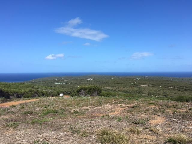
3.2     Description of the Environment and Bushfire Context
3.2.1 Topography and Landscape Features
The landscape character of the Shire is dominated by two main landscape types; vast wilderness and
cleared broad acre farmland.

The eastern part of the Shire is dominated by the FRNP. Approximately 140,000ha of the Park sits
within the Shire of Jerramungup. The remaining 190,000ha forms the western part of the Shire of
Ravensthorpe.

In addition to the large wilderness area of the National Park there are also large areas of UCL and
reserves. The topography in the central areas of the Shire of Jerramungup is mostly undulating farm
land. The coastal area has sandy beaches, extensive and high dune systems reaching 200m in elevation
and steep granite outcrops. The SEMC State Capability Framework recognises the importance of the
topography and landscape features in 4.2 The ecosystem is effectively managed to preserve natural
barriers that aid community protection and biosecurity barriers33.

The Palinup, Gardiner and Bremer Rivers are the only major river and valley systems within the Shire
of Jerramungup. These rivers are surrounded by significant vegetation corridors and are vested as
crown reserves.

The expansive areas of vegetation within the Shire of Jerramungup present an obvious bushfire risk,
this risk is further exacerbated by access challenges. The presence of dieback in areas of the park along
with sandy beaches, steep granite outcrops and dune systems means access is a serious challenge for
both risk management activities and suppression. Vehicle access in coastal and heavily wooded areas
is limited.

The Shire of Jerramungup has a history of people camping informally along remote beaches and
throughout the UCL. Access within these areas is restricted due to the topography, landscape features
and lack of formal access. This restricts the ability of responders to effectively manage and suppress
fires. It is also a challenge for the safe evacuation of people. Evacuation planning has been undertaken
by the LEMC and bushfire evacuation plans have been developed for the areas of coastal UCL around
Bremer Bay.

Suppression capability is an important consideration for this region as resources are limited and back
up is often delayed due to the vast distances between human settlements. Strategic risk management,
especially asset protection needs to give suppression capability due consideration. A significant issue
for suppression is the availability of emergency water. For example emergency water supply in the
rural residential area of Point Henry is limited to a single 20,000 litre tank (approximately 5 loads of a
4.4 Fire Appliance). The rural residential area is approximately 10 km from the town where the next
available water supply is located. It is estimated the turn-around time for a fire appliance to refill is 40
minutes under the current scenario.

The spread of Dieback requires serious consideration when determining bushfire risk management
and suppression strategies as the biodiversity and social values of the FRNP are threatened by

33
  State Emergency Management Committee – Capability Framework retrieved on 4 August 2016 from
http://www.semc.wa.gov.au

Shire of Jerramungup Bushfire Risk Management Plan 2017 – 2022    DRAFT                        Page 18
Phytophthora cinnamomi. The soil-borne pathogen, Phytophthora and other related pathogens infest
native plant communities causing death of susceptible species34. P&W have developed specific fire
management strategies for the wilderness zones of the FRNP35.

Strategic bushfire risk management in the area is undertaken to reduce risk but also to facilitate
suppression. Strategic breaks are often designed to enable back burning during response. In many
cases suppression of wildfires involves ‘dry’ suppression i.e. burning large blocks of vegetation to
achieve containment. Lack of access tracks, inaccessible terrain, extreme fire behaviours, emergency
water supply, cost and resource availability and the risk of introducing Phytophthera dieback or
disturbance of environmentally sensitive areas limits the opportunity to implement direct-attack
strategies (building a fireline using earth moving machinery directly on the fire edge).

Strategic bushfire risk management is also important as the town sites are surrounded by large areas
of vegetation. Bushfires that are able to access such large areas of fuel with limited suppression have a
better opportunity to develop into bigger fires that generate their own energy and pose a greater risk
to the community.

3.2.2 Climate and Bushfire Season
The climate of the Great Southern region is typically Mediterranean, with warm to hot dry summers
and mild, wet winters. The majority of rainfall occurs between May and September, with heaviest falls
during the winter months from June to August.

The Southern Oceans moderate the effect of temperature in the coastal areas of the Shire providing
smaller diurnal and seasonal variations and a milder climate than inland areas. Mean daily
temperatures vary from around 10 degrees in August to 26 degrees in February. As a result the fire
weather can vary significantly across the Shire. The Shire can simultaneously be experiencing Total Fire
Ban in the inland region while the coastal areas are experiencing mild weather.

Summers are very dry, with December to February receiving a monthly average of less than 25mm of
rain. Summers are typically very warm and cloudless although cooling afternoon sea breezes are
common. The hot dry summers and seasonal strong winds create an environment where there is
always a significant risk of bush fire, therefore a high degree of caution is required by residents and
visitors at all times.

The nearest weather station is Jacup and a climatic summary for the weather station is provided below
showing the climatic variables for the typical Southern fire season (December to March). The average
annual rainfall for the region varies from 360 mm in the north increasing to over 600 mm near the
south west coast.

34
  Managing External Dieback Threats to the Fitzgerald River National Park, South Coast NRM, December 2009.
35
  Department of Parks and Wildlife (1991) Fitzgerald National Park Management Plan Management Plan No. 15,
1991-2001

Shire of Jerramungup Bushfire Risk Management Plan 2017 – 2022   DRAFT                       Page 19
36
                      Figure 5 – Summary of Climatic Variables for the Shire of Jerramungup

The average annual rainfall distribution in the Shire is shown on Figure 6 below.

       Figure 6 – Average Annual Rainfall contour map Shire of Jerramungup Source: Department of Agriculture

36
  Meat and Livestock Australia (2017) downloaded 6 February 2017 from http://weather.mla.com.au/climate-
history/wa/jerramungup

Shire of Jerramungup Bushfire Risk Management Plan 2017 – 2022         DRAFT                           Page 20
Prevailing winds are from the north-west and south-east which can prove challenging during
suppression because they are generally strong, hot and dry (refer Figure 7 below). The NW wind
prevails between January and March which is the peak bushfire period. The mean number of days
over 30 degrees in this same period is 28. As a consequence the area experiences a fire danger rating
(FDR) of ‘Very High’ or above for approximately 28 days between Jan-March37.
38
Figure 7 – Wind Rose
Even though two-thirds of the annual rain falls in the six months between May and October, rainfall
has a relatively even distribution compared to other agriculture areas. The Shire also experiences
fewer hot dry winds, and increased cloud cover.
The average annual Class A pan evaporation varies from 1,600mm near the coast to about 2,000mm in
the north of the Shire. Pan evaporation is a measurement that combines or integrates the effects of
several climate elements: temperature, humidity, rain fall, drought dispersion, solar radiation, and
wind. The length of the growing season drops from 8 months on the coast to 5.5 months inland. 39
The average temperatures in summer for the region range from maximum of 27-30oC down to
minimum of 16oC. Winter average temperatures are 14oC down to 7oC maximum and minimum.
37
http://www.bom.gov.au/climate/averages/tables sourced on 28 April 2017.
38
Department of Agriculture and Food, Ravensthorpe Windrose, retrieved 10 April 2017 from
https://www.agric.wa.gov.au/climate-land-water/climate-weather
39
Shire of Jerramungup (2012), Local Planning Strategy downloaded 6 June 2016 from www.planning.wa.gov.au
Shire of Jerramungup Bushfire Risk Management Plan 2017 – 2022 DRAFT Page 21The Shire of Jerramungup under sections 17 and 18 of the Bush Fires Act 1954 has declared the following restricted and prohibited burning times:40 Zones 1, 2, 3, & 4, Shire of Jerramungup 1st October to 31st October - Permits required, Restricted Burning Time (RBT) 1st November to 5th February - BURNING PROHIBITED (PBT) 6th February to 18th April - Permits required, Restricted Burning Time (RBT) Zone 5 – Point Henry Peninsula, Shire of Jerramungup 1st September to 31st October - Permits required, Restricted Burning Time (RBT) 1st November to 5th February - BURNING PROHIBITED (PBT) 6th February to 31st May - Permits required, Restricted Burning Time (RBT) Burning on Sundays during the restricted and prohibited burning times is banned. These dates are subject to variation by agreement from time to time according to seasonal conditions. The extreme fire danger period occurs between December to February (inclusive) due to higher temperatures and low relative humidity. The Great Southern fire season is heavily influenced in January through to March by frequent lightning events triggered by the confluence of the cool moist air from the southern ocean and the warm inland dry air. This period is shouldered by a moderate fire danger period, of October/November and March influenced by warmer temperatures, at times strong easterly winds in the October/November period. The climate has an effect on the use of prescribed burning as a treatment strategy as often there are limited windows to safely conduct burns. Typically autumn is the preferred period for burning due to a higher soil moisture content reducing the impact of fire intensity on susceptible species. Burning is used extensively as a treatment method, it is used in balance with mechanical treatments such as parkland clearing, mulching and scrub rolling. It is important that treatment strategies are well coordinated to minimise the cost impacts of mobilisation etc. Historically the bushfire stakeholders in the area have worked well together to coordinate the implementation of treatment strategies. 3.2.3 Vegetation The vegetation in the Shire of Jerramungup is recognised as significant both for the threat it poses in terms of bushfire and also for its biodiversity and conservation value. The BRM Plan considers vegetation both as a source of risk and as an asset integral to balancing the environmental and conservation values of the region. The FRNP is one the largest and most botanically significant national parks in Australia. Nearly 20 per cent of Western Australia’s flora species are found within the National Park, many of which occur only within its boundaries41. The Shire of Jerramungup along with P&W and other natural resource management stakeholders i.e. The Gondwana Link, Friends of Fitzgerald River National Park, The Fitzgerald Biosphere Project, Bush 40 Shire of Jerramungup (2016), Fire Information, downloaded 4 October 2016 http://www.jerramungup.wa.gov.au 41 Managing External Dieback Threats to the Fitzgerald River National Park, South Coast NRM, December 2009. Shire of Jerramungup Bushfire Risk Management Plan 2017 – 2022 DRAFT Page 22
You can also read