Flood and Coastal Risk Management Strategy (2017-2022)
←
→
Page content transcription
If your browser does not render page correctly, please read the page content below
Flood and Coastal Risk Management
Strategy (2017-2022)

                 I
Laura Turvey
Local Authority Officer
                          Senior Environmental Protection Officer

Department                Environmental Health and Resilience

Address                   South Tyneside Council
                          Level 2, Town Hall & Civic Offices
                          Westoe Road
                          South Shields
                          NE33 2RL

Telephone                 0191 424 7921

E-mail                    Flood.Enquiries@southtyneside.gov.uk

Report
                          STC/FCRMS/17/01
Reference number
Date                      2017

                                       II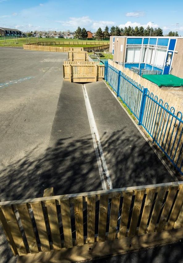
Table of Contents
Executive Summary .................................................................................................... I
Foreword .................................................................................................................... II
Abbreviations and Glossary of terms......................................................................... III
1.0 Introduction .......................................................................................................... 5
   1.1: What is South Tyneside’s Flood and Coastal Risk Management Strategy? .... 5
   1.2: Why do we need a Flood and Coastal Risk Management Strategy? ............... 5
   1.3: What will the strategy cover? ........................................................................... 6
2.0: Legislative Context .............................................................................................. 8
   2.1: The National Picture ........................................................................................ 8
      2.1.7: Other Relevant Legislation ...................................................................... 11
   2.2: The Regional Picture ..................................................................................... 11
   2.3: The Local Picture ........................................................................................... 13
   2.4: Partnership working ....................................................................................... 16
   2.5: Powers and responsibilities ........................................................................... 16
      2.5.1: Risk management authorities .................................................................. 16
      2.5.1.1: Internal ................................................................................................. 16
      2.5.1.2: External ................................................................................................ 18
      2.5.1.3: Others .................................................................................................. 18
Part 1 Flood Risk Management ................................................................................ 20
3.0: Flood risk in South Tyneside ............................................................................. 21
   3.1: What is Flood Risk? ....................................................................................... 21
   3.2: Historic Flooding ............................................................................................ 22
   3.3: Types of flood risk in South Tyneside ............................................................ 23
      3.3.1: Surface water flooding ............................................................................ 23
      3.3.2: Groundwater flooding .............................................................................. 23
      3.3.3: River Flooding (Fluvial) ........................................................................... 24
      3.3.4: Coastal Flooding ..................................................................................... 24
      3.3.5: Sewer Flooding ....................................................................................... 24
      3.3.6: Highways Flooding .................................................................................. 24
   3.4: Factors increasing flood risk .......................................................................... 25
      3.4.1: Topography ............................................................................................. 25
      3.4.2: Climate change ....................................................................................... 25
      3.4.3: Drainage capacity ................................................................................... 26
      3.4.4: Increase in impermeable surfaces .......................................................... 26
      3.4.5: Location................................................................................................... 26
      3.4.6: Flooding, coastal erosion and climate change ........................................ 27
                                                              III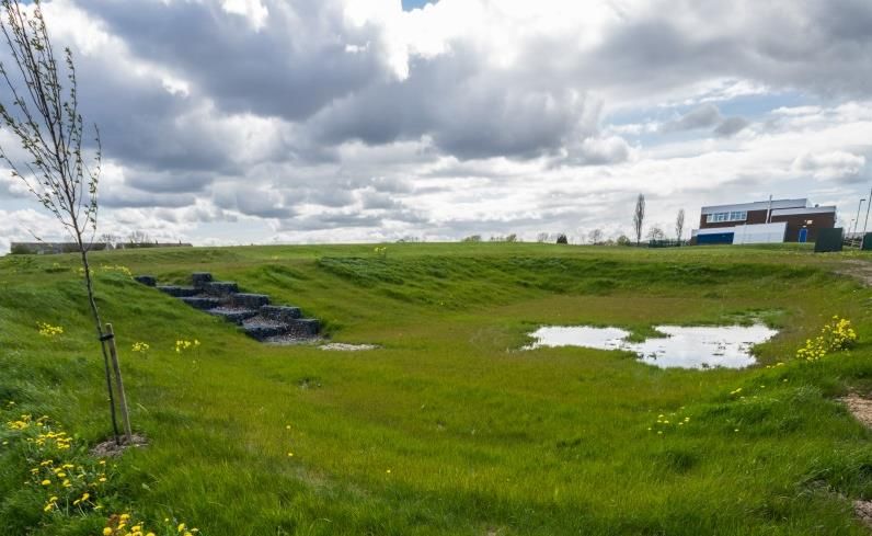
4.0: Flood Risk Management ................................................................................... 28
   4.1: National Strategy ........................................................................................... 28
   4.2: Emergency planning ...................................................................................... 29
      4.2.1: Flood Investigation .................................................................................. 30
      4.2.2: Prioritisation ............................................................................................ 30
   4.3: Schemes ........................................................................................................ 31
   4.4: Sustainable Drainage Systems (SUDS) ........................................................ 32
   4.5: Environment, landscape and maintenance .................................................... 33
      4.5.1: Land management .................................................................................. 33
      4.5.2: Maintenance............................................................................................ 34
      4.5.3: Drainage Infrastructure ........................................................................... 34
Part 2 Coastal Erosion Risk Management Strategy ................................................. 35
5.0: Coastal Risk in South Tyneside ........................................................................ 36
   5.1: What is coastal risk? ...................................................................................... 36
   5.2: Historic events ............................................................................................... 36
   5.3: Types of risk .................................................................................................. 36
      5.3.1: Storms ..................................................................................................... 36
      5.3.2: Coastal defence breach .......................................................................... 37
      5.3.3: Tidal surge .............................................................................................. 37
   5.4: Factors increasing coastal risk....................................................................... 37
      5.4.1: Our Coastal Environment ........................................................................ 37
      5.4.2: Geology, topography and relief of South Tyneside’s Coastline ............... 38
      5.4.3: The Challenges of Climate change ......................................................... 38
6.0: Coastal Management ........................................................................................ 39
   6.1: National Strategy ........................................................................................... 39
   6.2: Coastal Investigation ..................................................................................... 39
   6.3: Coastal management areas ........................................................................... 39
      6.3.1: Management area 1 – River Tyne to South Pier ..................................... 39
      6.3.2: Management area 2 - Herd Sands .......................................................... 41
      6.3.3: Management Area 3 - Trow..................................................................... 43
      6.3.4: Management Area 4 – Frenchman’s Bay to Lizard Point ........................ 44
      6.3.5: Management Area 5 – Lizard Point to Souter Point ................................ 46
      6.3.6: Management Area 6 – Souter Point to Whitburn ..................................... 47
7.0: Delivery of Part 1 and 2 ..................................................................................... 48
   7.1: Funding .......................................................................................................... 48
   7.2: Flood and coastal risk management delivery ................................................. 49
   7.3 Residual Risk .................................................................................................. 50

                                                            IV
8.0 Reviewing the Strategy and Next steps.............................................................. 51
   8.1: Review ........................................................................................................... 51
   8.2: Next Steps ..................................................................................................... 51

Table of Figures
Figure 1: What is expected during the planning stages with regards to flood risk.
(Matrix from the LASOO Best Practice Guidance. ................................................... 17
Figure 2: Some of the Fellgate Flood Alleviation Scheme SUDS Features .............. 33
Figure 3: Littlehaven Sea Wall ................................................................................. 41
Figure 4: Herd Sands Access Ramp and Gabions ................................................... 42
Figure 5: Trow Quarry Coastal Protection Scheme .................................................. 44
Figure 6: Funding Application Steps ........................................................................ 50

Appendix
Appendix 1: Action Plan ............................................................................................54

                                                             V
Executive Summary
Welcome to South Tyneside’s Flood and Coastal Risk Management Strategy

The floods that took place across the UK in 2007, 2010, 2012 and 2015 highlighted the
devastating impacts that flooding and coastal erosion can have on communities. In 2007, 13
people lost their lives, approximately 48,000 households and 7,300 businesses were flooded
and billions of pounds worth of damage was caused.

Since December 2013 and throughout January and February 2014 much of the UK has not
only experienced unusually high tides in coastal regions but also persistent rainfall which has
led to severe flooding, damage and loss of life.

South Tyneside Council recognises the importance of planning and managing flood risk to
reduce the impact it has on our community. Flooding can have a devastating effect on both
residents and businesses alike, and although we may not be able to prevent flooding
altogether, it is envisaged that this strategy will coordinate our services so that flood risk is
reduced and the aftermath of flooding incidents is minimised.

Our Flood and Coastal Risk Management Strategy aims to adopt a new approach to flood
risk management which will see improved communication and close working partnerships
with other organisations involved in flood risk management to protect the public and
economy from immediate and future risks. It will show how we are attempting to create a
balance between modelled risk and the work needed to support areas previously affected by
flooding. As a result, our community will be better informed with regard to flood risk and how
it can be reduced.

The strategy has been developed in consultation with our partners setting out how we plan
to respond to flooding incidents which are predicted to become more frequent due to the
milder, wetter winters, more frequent downpours and higher sea levels resulting from climate
change.

This strategy fulfils the requirements set by the Flood and Water Management Act 2010 and
sets a programme of local actions for the next five years so that we meet the challenges of
managing flood and coastal erosion risk within catchments and along the coast and balance
the needs of communities, the economy and the environment.

                                                I
Foreword
Flooding can be devastating and those impacts have been witnessed in many communities
across the country in recent years. Flooding has particularly affected South Tyneside with
large-scale damaging events like those in 2012 where many properties were internally
flooded, a number of roads were left impassable and businesses were also affected. Due to
the increasing effects of climate change we need to make sure that on both a local and
national scale, we are aware and prepared for flooding and coastal erosion.

South Tyneside has a number of different sources of possible flooding such as ordinary
watercourses, overland flow, main rivers and the sea. Proximity to these sources can
increase the likelihood and impacts of flooding so we, as a borough, must be informed and
prepared.

I represent the borough on the Northumbria Regional Flood and Coastal Committee. This
helps to keep me informed of the current position across the region and to promote the case
for flood and coastal investment in South Tyneside. My attendance on this Committee helps
to ensure that the communities of South Tyneside are better protected and well versed in
how to respond to future flooding and coastal events. With greater likelihood of more
frequent and intense storms and events in the future due to climate change, this is becoming
increasingly important.

There have been a number of projects already undertaken in the borough and more are
planned for the future, many of which are outlined in this strategy.

Partnership working is very important in tackling the problems faced by flooding and coastal
erosion. As Lead Local Flood Authority, it is important that we work well and in partnership
with others, such as the Environment Agency, Northumbrian Water Group, and other local
authorities. Partnership working ensures projects can be delivered in a more cost effective
way with less disruption. Close working with local communities allows this to happen and
ensures we can focus on reducing risk in more vulnerable areas. Some project examples
are the award winning Littlehaven Promenade and Sea Wall and the Fellgate Estate Flood
Alleviation Scheme.

As flooding and coastal erosion are natural processes, we cannot prevent these from
happening. It is our duty however, to work together to limit the risk and effects of both of
these processes over time and this strategy outlines how we intend to achieve this.

Councillor Moira Smith,
Lead Member for Area Management and Community Safety

                                               II
Abbreviations and Glossary of terms
                           Annual Exceedance Probability. The chance of a flood happening
  AEP
                           expressed as a percentage chance of occurring in any 1 year
  Asset                    A structure or a system of structures used to manage flood risk.
                           An area that serves a river with rainwater. Every part of land where the
  Catchment
                           rainfall drains to a single watercourse is in the same catchment.
  CFMP                     Catchment Flood Management Plan
  Coastal erosion          The wearing away of the coastline, usually by wind and/or wave action
                           Occurs when coastal defences are unable to contain the normal
                           predicted high tides that can cause flooding, usually when a high tide
  Coastal flooding
                           combines with a storm surge (created by high winds or very low
                           atmospheric pressure)
                           The process of obtaining permission to add/amend structures in/near to
  Consenting
                           a watercourse
                           A drainage area where the flood risks from surface water run-off are
  Critical Drainage Area
                           likely to be most significant
                           A covered structure under a road, embankment etc. to direct flow of
  Culvert
                           water
                           A structure that is used to reduce the probability of floodwater or coastal
  Defence                  erosion affecting a particular area (for example, a raised embankment or
                           sea wall)
  DEFRA                    Department for Environment, Food and Rural Affairs
                           Previously recorded flooding issues relating to surface and foul water
  DG5
                           sewers, held by the sewerage undertaker
  EA                       Environment Agency
  EU                       European Union
  FCERM                    Flood and Coastal Erosion Risk Management
  FDGiA                    Flood Defence Grant in Aid
  Flood                    The temporary cover by water of land not normally covered with water.
                           An area determined as having a significant risk of flooding in accordance
  Flood Risk Area
                           with guidance published by DEFRA
  FWMA                     Flood and Water Management Act (2010)
                           Water that is below the surface of the ground and in direct contact with
  Groundwater
                           the ground or subsoil
                           Occurs when water levels in the ground rise above the natural surface.
  Groundwater flooding     Low-lying areas underlain by permeable strata are particularly
                           susceptible.
                           Areas determined by the Environment Agency as indicatively having a
  Indicative Flood Risk    significant flood risk, based on guidance published by DEFRA and the
  Areas                    use of national datasets. These indicative areas are intended to provide
                           a starting point for the determination of Flood Risk Areas by LLFAs.
  LDF                      Local Development Framework
  LLFA                     Lead Local Flood Authority
  LPA                      Local Planning Authority
  LRF                      Local Resilience Forum
                           A watercourse shown as such on the main river Map, and for which the
  Main river
                           Environment Agency has responsibilities and powers
                           National Receptor Dataset – A collection of risk receptors produced by
  NRD
                           the Environment Agency
  NRFCC                    Northumbria Regional Flood and Coastal Committee
  NWG                      Northumbrian Water Group

                                                III
The Water Services Regulation Authority, or OFWAT, is the body
OFWAT                  responsible for economic regulation of the privatised water and
                       sewerage industry in England and Wales.
                       All watercourses that are not designated main river, and which are the
Ordinary Watercourse   responsibility of Local Authorities, or where they exist Internal Drainage
                       Boards
                       Project Appraisal Report - a report that used to be required to outline a
PAR                    project and attain funding. The Five Case Business Model has now
                       replaced this.
PFRA                   Preliminary Flood Risk Assessment
RBD                    River Basin District
                       The process of rebuilding, restoring and rehabilitating the community
Recovery
                       following an emergency
                       The ability of the community, services, area or infrastructure to withstand
Resilience
                       the consequences of an incident
                       Organisations that have a key role in flood and coastal erosion risk
                       management as defined by the Flood and Water Management Act
Risk Management
                       (2010). These are the Environment Agency, Lead Local Flood
Authorities
                       Authorities, Internal Drainage Boards, Water Companies and Highways
                       Authorities.
                       Occurs when water levels in a channel overwhelms the capacity of the
River flooding
                       channel.
SFRA                   Strategic Flood Risk Assessment
SuDS                   Sustainable Drainage Systems
                       Occurs when rainwater does not drain away through the normal
Surface Water
                       drainage system or soak into the ground, but lies on or flows over the
Flooding
                       ground instead.
SWMP                   Surface Water Management Plan

                                            IV
1.0 Introduction
Section Overview
In this section, we will cover the following:
What is the Flood and Coastal Risk Management Strategy?
Why do we need it?
What will the Strategy cover?
Review
1.1 What is South Tyneside’s Flood and Coastal Risk Management
Strategy?
The Flood and Coastal Risk Management Strategy details our approach to flood risk and coastal
management over the next five years (2017-2022). The strategy will identify some broad actions
to be implemented in the near future and sets out the steps we intend to take in the long term.
The strategy has adopted a new approach to flood risk management. This will see improved
communication and close working partnerships with other organisations involved in flood risk
management and better communication with the public about flood risk, coastal erosion and what
can be done to mitigate the impacts.
The strategic approach adopted, together with the comprehensive action plan, will be key to
managing flood risk and reducing the impact it has on our local communities. Part 1 of the
strategy addresses flooding from surface water, ground water and ordinary watercourses. Sewer
and river flooding are also considered.
Part 2 examines coastal erosion risk management including how we aim to reduce the threat of
coastal erosion as well as how we deliver social, economic and environmental benefits to the
borough.
South Tyneside’s strategy reflects the content of the National Flood and Coastal Erosion Risk
Management Strategy and includes a 5-year action plan that details the significant actions
needed to reduce the risk to the borough.
1.2 Why do we need a Flood and Coastal Risk Management
Strategy?
Sir Michael Pitt’s review: ‘Learning Lessons from the 2007 Floods’ identified gaps in the way that
flood risk is managed. The Government accepted the 92 recommendations made in the report.
These recommendations were transposed into UK legislation under The Flood and Water
Management Act 2010 (FWMA), and gained royal assent in April 2010.
In fulfilment of Section 7 of the FWMA, the Environment Agency produced a national flood and
coastal erosion risk management strategy. The national strategy provides a strategic overview
role of all sources of flooding and coastal erosion supports local decision-making and
engagement in flood and coastal erosion risk management, and aids lead local flood authorities
5in the development of their own local strategies. The Flood and Water Management Act 2010
Section 7 also requires each local authority to produce a local flood risk strategy that is
consistent with the national strategy, therefore South Tyneside Council designated as a Lead
Local Flood Authority (LLFA) has decided to adopt a similar approach and produce a combined
coastal and flood risk management strategy.
Current climate change predictions forecast more extreme weather events, milder wetter winters
and rising sea levels, which will inevitably increase the risk of increased flooding and coastal
erosion. This is not just a local problem but one that is faced regionally, nationally and globally.
Over the past few years, the UK has experienced the effects of severe weather first-hand.
In 2012, South Tyneside experienced several episodes of extreme rainfall, which affected
hundreds of properties, businesses and the local road network. In December 2013 we saw the
arrival of several severe weather storms in the UK causing unusually high tides, persistent heavy
rainfall and strong winds. Coastal regions experienced the highest tides on record not only
destroying sea defences, infrastructure and cliff faces, but taking with it homes and the
belongings of those living next to the sea.
As more heavy rain fell in early 2014, ground conditions became saturated, rivers and
watercourses reached capacity and broke their banks and sewerage systems were unable to
cope with the extra rainfall. Critical infrastructure was destroyed and essential services including
power supplies, transport links and telecommunications were disrupted across many areas.
This Flood and Coastal Erosion Risk Management Strategy will ensure that South Tyneside has
policies in place to address these issues and a governance structure that demonstrates a
collaborative working approach, both within South Tyneside Council and with external partners.
1.3 What Will the Strategy Cover?
This strategy provides a framework for delivering local flood and coastal risk management in
South Tyneside and has the following aims and objectives:
Aim and objectives for Part 1 Flood Risk Management:
Aim:
To improve knowledge and understanding of local flood risk for both Risk Management
Authorities and local communities; to work together to create innovative solutions and
make sure resources are targeted for greatest affect to minimise flood risk.
Objectives:
• To provide an explanation of stakeholder responsibilities in flooding issues
• To provide an understanding of the risks of various types of flooding
• To ensure an integrated approach is followed and actions undertaken in response to
flooding do not affect other areas.
• To provide an explanation of how areas at risk of flooding are assessed and the
resources prioritised
• To state how stakeholders will work together to both manage resources and share
information.
• To enable residents and businesses to be aware of the flood risks related to the
relevant properties and enable them to manage the residual risk
• To communicate with the public to ensure that there are realistic expectations of the
outcomes of flood risk management.
6• To ensure that planning decisions are informed by current understandings and to
research flood matters and by previous issues to ensure that, developments do not
create additional flood risk.
• To ensure that emergency plans and responses to flood incidents are effective so
that communities are able to respond effectively.
• To minimise the number of properties that are flooded internally
Aim and Objectives for Part 2 Coastal Erosion Risk Management:
Aim:
To sustainably enhance our coastal and estuarine environment to encourage tourism and
regeneration, while protecting our cultural, environmental and economic assets and
meeting the challenges of climate change and natural coastal erosion.
To ensure that we achieve the aim for this part of the strategy, our objectives are to:
Manage our coastline in a practical and sustainable way, protect valuable assets
wherever possible and prevent or minimise the impact of flooding, while protecting
environmental designations
Promote the importance of the coast, foreshore and river frontage
Encourage stakeholder participation and support effective liaison through the North East
Coastal Group (NECG)
Highlight the need for strategic planning in light of climate change induced flooding and
sea level rise
Promote sustainable developments that neither rely on costly or maintenance-intensive
defences nor increase the risk of flooding
Facilitate improvement of our designated bathing beaches, increase tourism and
economic wellbeing associated with the coast; and work with riparian landowners to
protect valuable assets along the coastline and estuary
Participate in the Local Government Authority Coastal Special Interest Group and in
regional monitoring to increase understanding of the processes that impact on our
coastline and to enable better prediction of coastal erosion rates
72.0 Legislative Context
Section Overview
In this section, we will cover the following:
The National Picture
The Local Picture
Partnership working
Roles and Responsibilities
2.1 The National Picture
Legislation Summary Relates to
Making Space for This is the Government’s strategy for Flood & Coastal Erosion Risk Management. It takes a holistic Flood and Coastal
Water (2005) approach to management of risk from all forms of flooding (river, coastal, groundwater, surface run-off and Management Risk
sewer) and coastal erosion. The strategy aims to ensure sustainable development, and contribute to Strategy
implementation of the Water Framework Directive by addressing water quality issues through effective
management.
The Flood and Water This Act sets out the agencies responsible for managing flood risk. The Environment Agency was given a Flood Risk Strategy
Management Act strategic overview role and some local authorities, such as South Tyneside Council, were designated as
(2010) LLFA. LLFA’s are given responsibility for the co-ordination and management of local sources of flood risk
from groundwater, surface water and ordinary watercourses. The Act identifies LLFA’s, Internal Drainage
Boards, Highways Authorities and the Environment Agency as risk management authorities. The relevant
authorities are required to co-operate in exercising their functions under the legislation.
8Name Summary Relates to
The Flood Risk These regulations transpose the EU Flood Directive into law in England and Wales. The regulations require Flood Risk
Regulations (2009) local authorities and the Environment Agency to undertake a Preliminary Flood Risk Assessment (PFRA) to Strategy
identify those areas that meet the criteria of a ‘significant flood risk area’ as defined by the regulations. South
Tyneside’s PFRA is undertaken in 2011 and although no significant flood risk areas are identified under the
criteria given, it is appreciated that those communities impacted by flooding may view it as significant. The
PFRA is to be reviewed in 2017.
Coast Protection Act The Coast Protection Act 1949 provides the legal framework for the protection of the coast against erosion and Flood and Coastal
(1949) encroachment by the sea. This Act gives Local Authorities permissive powers to undertake coast protection Management Risk
works on their frontage. A coast protection authority has the power to carry out any necessary or expedient Strategy
coast protection works for the protection of any land in its area from erosion or encroachment by the sea.
The National Planning This requires developers to consider flood risk within new development. Developers need to assess and Flood and Coastal
Policy Framework demonstrate how flood risk from all sources impacts on a development, how it will be managed onsite and how Management Risk
(NPFF) (2012) it affects others. Future climate change predictions must be considered. A site-specific flood risk assessment Strategy
is required for those developments, which are deemed to be at high risk of flooding.
As of 6th April 2015, Sustainable Drainage Systems (SuDS) were formally introduced into the planning
process. Any major planning application of 10 or more houses or a major commercial scheme is expected to
include sustainable drainage systems before they are granted planning permission. Sustainable drainage
systems include features such as detention basins, ponds and permeable paving. Their purpose is to intercept
and store surface water run-off to stop water running directly into the drainage systems and overwhelming its
capacity. SuDS replicate natural drainage processes, which were present before the developments were built.
The National Strategy The National Strategy provides a framework for all of the flood risk and the coastal erosion risk management Flood and Coastal
for Flood and Coastal authorities. It sets out the long-term objectives to manage flood and coastal erosion risks and the measures Management Risk
Erosion Risk proposed to achieve them. It encourages the management of flood and coastal erosion risk using all options in Strategy
Management a co-ordinated and effective way across all catchments.
The Revised Bathing In 2015, this directive integrated into national law; its overall objective remains the protection of public health Coastal Risk
Water Quality while bathing, but it also offers an opportunity to improve management practices at bathing waters. The new Strategy
Directive (2006/7/EC) revision of this directive tightens up the water quality standards and assesses all bathing waters against four
categories, (excellent, good, sufficient and poor). All bathing waters across the UK should hold a minimum
quality categorisation of “sufficient”, with some limited exceptions, by 2015. Designated Beaches in South
Tyneside at Sandhaven and Marsden Bay exceeded this target.
9Integrated Coastal This is the UK’s response to the EU recommendation for an integrated approach to the management of coastal Coastal Risk
Zone Management areas. The objective of this programme is to establish sustainable levels of economic and social activity in our Strategy
(ICZM) coastal areas while protecting the environment.
Shoreline Collectively provide a long-term strategy for coastal defence in England. They provide a large-scale Flood and Coastal
Management Plans assessment of the risks associated with coastal processes and present a long-term policy framework to reduce Management Risk
(SMP’s) these risks to people and to the developed, historic and natural environment in a sustainable manner. Strategy
The ‘Marine Bill’ White This was prepared to help deliver the Government's vision ‘for the marine environment to be clean, healthy, Coastal Risk
Paper safe, productive and biologically diverse’. Included in it are policy proposals for the achievement of a legal and Strategy
management framework for the seas, with the aim of keeping them clean and healthy for future generations.
The Local Coastal Risk
Government This Group comprised of Elected Members from coastal local authorities. Its principal aim is to establish Strategy
Association's Special improved governance, management and community well-being along the UK coastline and to identify
Interest Group On appropriate and sustainable funding strategies to support this aim. South Tyneside Council is a member and
Coastal Issues Vice Chair of the Local Government Association's Coastal Special Interest Group
The Water Resources Flood Risk
Act 1991 (as The Act includes the current legal basis for various flood defence matters including schemes to reduce the Strategy
amended) risks of flooding from rivers and the sea.
Land Drainage Act This Act gives the Council permissive powers to undertake flood defence works and powers of enforcement on Flood Risk
1991 (as amended) ordinary watercourses. Strategy
102.1.7 Other Relevant Legislation
Other pieces of legislation relative to flood risk are:
The Conservation of Habitats and Species Regulations (2010)
The Climate Change Act (2008)
The Civil Contingencies Act (2004)
The Strategic Environmental Assessment (SEA) Directive (2001)
The Water Framework Directive 2000 (WFD)
The Land Drainage Act 1991 and 1994
The Marine and Coastal Access Act 2009
The Countryside Rights of Way Act (2000)
Building Regulations Part H (amended 2010)
The Highways Act 1980
Water Resources Act 1991
Town and Country Planning Act 1995 (amended 2008)
2.2 The Regional Picture
In certain cases, the co-ordination of Flood Risk and Coastal Erosion risk management needs to be considered at a wider scale than a Local
Authority’s administrative boundary, such as a river catchment level or a coastal sediment cell scale. Using a regional overview, allows risk,
actions, impacts and all interactions to be considered collectively. A range of policy documents and guidance exists at this level.
Name Summary Relates to….
Northumbria Regional The Committee manages the risk of flooding across the North East by setting Environment Agency Flood Flood and Coastal
Flood and Coastal defence policy, managing medium and long-term business plans for the area and determining the local levy Management Risk
Committee (NRFCC) on council tax for work that cannot be funded from central government grant-in-aid. The Council is Strategy
represented on this Committee to ensure that local needs and priorities are considered. It also provides a
link between the Environment Agency, LLFAs, other risk management authorities and other relevant bodies.
In this way it is possible to build understanding of regional flood and coastal risks that will facilitate more
coherent partnership working.
11River Basin The Management Plan covers the Northumbrian River Basin district which is made up of 452 water bodies Flood Risk Strategy
Management Plan 2
and covers an area of 9,029km from the Scottish Border to just South of Guisborough, and from the
Pennines east to the North Sea.
The RBMP describes the work to be carried out to improve the water environment over a number of years.
Overall, it is expected that the implementation of those measures will achieve significant environmental
improvements and ensure no deterioration to the environment.
The first review of this document confirms that measures have been successful, with 98% of measures
implemented. The aim for the plan remains the same, looking towards further improvements to the quality
and ecology of the river basin areas by 2021 and beyond.
Catchment Flood In relation to South Tyneside the highest risk is in Hebburn from the River Don due to restrictive culvert Flood Risk Strategy
Management Plan capacity and surface water runoff. However, the main areas at risk already benefit from defences. It is
(2009) concluded that the risk is not likely to increase significantly in the future. Suggestions for risk minimisation in
the future include making sure watercourses are clean and clear, maximising capacity for flow. It is also
suggested that South Tyneside Council promote the flood warning services where applicable and provide
advice in ways such as through this document.
Flood Risk Strategy This document acts as the Flood Risk Strategy for South Tyneside. It outlines the current and possible Flood Risk Strategy
future problems along with actions taken to reduce risk across the borough. Reducing and managing flood
risk can minimise damage and subsequent costs for owners and occupants of property and business in the
event of a flood.
122.3 The Local Picture
Consideration of Flood Risk and Coastal Management needs to be co-ordinated at a local scale, where there can be an appreciation of local
circumstances and risk areas. South Tyneside Council has undertaken a number of detailed studies within its Surface Water Management Plan
and historic flooding incidents help to inform local flood risk management.
Name Summary Relates to
Strategic Flood Risk Local Planning Authorities (LPAs) carry out Strategic Flood Risk Assessments (SFRAs) to Flood Risk Strategy
Assessment 2010 provide an evidence base in relation to flood risk to help inform spatial planning decisions. They
are a central source of relevant flood risk information for the LPA. The SFRA categorises the
vulnerability of flooding into four bands:
Zone 1 – Low probability
Zone 2 – Medium probability
Zone 3a-High probability
Zone 3b – Functional floodplain
Within South Tyneside, there are 3 sites close to the River Don which fall into Zones 3a/b.
These are also identified as Critical Drainage Areas (CDA). The SFRA identified Critical
Drainage Areas across South Tyneside.
These areas are at significant risk of surface water flooding and where larger developments are
planned in these areas, recommendations should be made for the provision of future surface
water management. This may include the use of Sustainable Drainage Systems (SuDS).
13Preliminary Flood Risk The Preliminary Flood Risk Assessment (PFRA) considered past and potential future flood risk Flood Risk Strategy
Assessment 2011 across the administrative area from all local sources of flooding: surface water, ground water,
and ordinary watercourses. The report collated evidence of 152 historic flooding events,
varying in impact and significance. The recorded events had many different reporting
mechanisms, and acknowledged that on a local level these were significant to those
communities affected. However, the level of local flood risk within South Tyneside was not
considered to be nationally significant, and no areas were assessed as meeting the indicative
flood risk area thresholds, as defined by the national criteria produced by DEFRA. Collating the
historic data for the PFRA highlighted the limited extent to which surface water flooding events
have been recorded across South Tyneside, particularly extent and depth information.
The Environment Agency national data sets were assessed within the PFRA This included the
Areas Susceptible to Surface Water Flooding and a Flood Map for Surface Water. It was
recognised that the Flood Map for Surface Water is more representative of surface water flood
risk within South Tyneside; however this map is not suitable for identifying whether individual
properties are at risk.
The datasets were used to estimate the number of properties at risk. For a rainfall event with a
0.5% AEP (1 in 200 year) chance of occurring, approximately 4,000 residential properties and
100 businesses were estimated to be at risk from flooding to a depth of 0.3m.
Contaminated Land Sets out the Council’s framework for identifying and dealing with contaminated or potentially Coastal Risk Strategy
Strategy contaminated land under Part IIA of the Environmental Protection Act 1990. The Borough has
inherited a legacy of land formerly used for heavy industrial and mineral activities. Some of
these activities have been undertaken close to the coast and it is prudent that the approaches
set out in the Contaminated Land Strategy link closely to our coastal management activities.
Local Development The South Tyneside Local Development Framework (LDF) is our current statutory development Flood and Coastal Management
Framework plan and guides the future development and use of land in the borough. The LDF’s suite of Risk Strategy
Development Plan Documents are currently being reviewed in the form of a new-style Local
Plan that will set out the spatial strategy and policies for the sustainable use of land and
buildings in the borough over the next 15-20 years, laying the foundations for regeneration and
economic growth while ensuring protection of our most valuable environmental assets. Along
with national policy and guidance, the Plan’s policies (supported by non-statutory advisory
guidance in Supplementary Planning Documents) set the basis for assessing all planning
applications and other development proposals. Coastal erosion and flood risk issues are
enshrined in the Plan.
14Local Transport Plan Sets out current and future transport links and needs. Environmental sustainability is one of the Flood and Coastal Management
overarching policy principles and therefore coastal erosion and flooding issues will need to be Risk Strategy
addressed when assessing current and future transport needs.
Emergency Response Supported by a specific Flood Response Plan which sets out the arrangements that the Council Flood and Coastal Management
Plan and partners have in place for responding to and mitigating the impacts of major and critical Risk Strategy
incidents, including flooding
The Council’s Creates and implements work programmes centred on improving the environment, Coastal Risk Strategy
Foreshore Steering infrastructure, tourism and regeneration along the foreshore. The steering group ensures the
Group foreshore remains a thriving tourist attraction for the borough.
152.4 Partnership Working
In South Tyneside, we realise the importance of partnership working to deliver our strategy
and achieve our aims and objectives. Flood risk issues are rarely managed by a single
organisation or landowner, therefore it is recognised that partnership working will be
essential in developing solutions. Partnership working has been fundamental in the
development of both elements of this strategy.
The management of flood risk and coastal erosion is shared amongst different partner
organisations both internal and external to South Tyneside Council and each with their own
roles, responsibilities and powers. Partnership working was one of the key messages of the
Pitt Review.
South Tyneside has representation on a variety of regional groups designed to share
expertise and ensure that flood risk is addressed strategically. These regional groups
operate at different levels from senior management level, to officer level. This ensures that
the correct information is distributed to the most relevant officers. The groups can include
officers from regional local authorities, the private sector, Councillors and colleagues from
other departments within the Council.
2.5 Powers and Responsibilities
This section outlines the main partners and management authorities who have
responsibilities in South Tyneside and their role in relation to flood risk management, powers
and responsibilities.
2.5.1 Risk Management Authorities
Risk Management Authorities (RMA) are defined under Section 6 of the Flood and Water
Management Act 2010 and are made up of a range of internal and external partners
including the following:
A Lead Local Authority (South Tyneside Council)
The Environment Agency
Water and Sewerage Company (Northumbrian Water Group)
An Internal Drainage Board
2.5.1.1 Internal
Lead Local Flood Authority
South Tyneside Council is a Lead Local Flood Authority. The Flood and Water Management
Act 2010 gives South Tyneside Council a strategic overview of local flooding issues and
flooding management functions. These include:
The duty to investigate flooding
The power to regulate ordinary watercourses
The duty to maintain a register of significant structures and features for example
those that protect from flooding
To act as a statutory consultee in planning applications where flood risk and SuDS
are material considerations
The power to undertake work that manages surface water runoff or groundwater.
16 The power to request information from a person in relation to the authority’s risk
management functions
Contribution towards the achievement of sustainable development through exercising
risk management functions
In addition to the above responsibilities, an educational role exists to ensure that where no
action can be taken, householders and businesses can be given the relevant advice to help
protect their property.
Emergency Planning
As a category one responder under the Civil Contingencies Act 2004, South Tyneside
Council’s role, as set out in the Multi Agency Flood Plan, is to develop Emergency Plans and
Business Continuity Plans, make arrangements for Civil Preparedness information (weather
warnings, advice etc.) and to work in partnership with other key responders.
Planning Authority
The Council as CPA has the determining responsibility for planning applications for new
developments, both commercial and residential. Where a scheme is above 1 Hectare in size
a Flood Risk Assessment is required. When a development falls within an area of flood risk
or is located in flood zones 2 and 3, a flood risk assessment is compulsory. Options should
be considered to ensure the new development does not increase flood risk for any other
properties in the surrounding area. This can be done through the use of Sustainable
Drainage Systems (see section 4.4). Below is a matrix from the Local Authority SUDS
Officer Organisation (LASOO) Best Practice Guidance of what would be expected during the
different planning stages with regards to flood risk (Figure 1)
Figure 1: What is expected during the planning stages with regards to flood risk. (Matrix from the LASOO Best Practice
Guidance.
17Highways
As well as the maintenance of roads and streets, the Council in its role of LHA is responsible
for maintenance and cleaning of gullies and highway drainage. The Environmental
Protection and Resilience units work closely with the LHA in responding to flood complaints.
Internal Drainage Board
There is no internal drainage board for South Tyneside.
2.5.1.2 External
Environment Agency (EA)
The Environment Agency is a non-departmental Public Body responsible to the Secretary of
State for Environment, Food and Rural Affairs. It was established to protect and improve the
environment and to contribute to sustainable development by implementing UK government
policies.
The EA is responsible for main rivers and coastal flooding. Its functions include
implementing flood defence schemes and working with Lead Local Flood Authorities and
communities to respond to area priorities.
Amongst many other responsibilities, the EA is also responsible for issuing flood warnings
for fluvial (river) and coastal flood risk and responding to flood incidents as a result of main
river or coastal flooding. The EA also administer funding for flood and coastal erosion risk
projects and maintenance on behalf of DEFRA.
Northumbrian Water Group
Northumbrian Water Group (NWG) is responsible for managing risks from water supply,
surface water, foul and combined sewers.
Water and sewage companies have several responsibilities around flood risk management.
A few of these key responsibilities include:
Responding to flooding incidents involving their assets.
Undertaking investment to reduce the risk of sewer flooding – regulated by OFWAT
Providing, maintaining and operating public sewers for the purpose of effectively
draining an area
Adopt assets offered for adoption.
The planning authority will consult Northumbrian Water Group as a non-statutory consultee
where appropriate.
2.5.1.3 Others
Private Land Owners/Individuals
It is the responsibility of homeowners and businesses to look after and maintain their own
property – this includes protecting it from flood risk. Although there may be circumstances
where other parties may be liable, there will be many occasions when it is the responsibility
of the property owner. It is therefore important for homeowners to know whether or not their
property is at risk and if so, to have knowledge of the measures that can be taken to ensure
their properties are adequately protected. Protection could be afforded through either the
use of permanent features including flood doors, air bricks and sealants or temporary
measures such as sandbags, flood guards etc. Information on properties in a flood risk area
18is available via the Environment Agency website. This includes properties at risk of surface
water, coastal and river flooding.
A common risk of flooding to properties is the run off from fields during episodes of heavy or
prolonged rainfall. Many of the fields in South Tyneside are privately owned and let to
farmers. South Tyneside Council continues to work closely with these organisations and the
farmers to try to reduce the risk to surrounding homeowners.
Developers
Developers have a responsibility to ensure that developments are appropriate and should
not increase flood risk elsewhere. They have a vital role in delivering sustainable drainage
where possible and developments should aim to reduce flood risks both on and off site and
at the same time ensure that the development will not cause flooding elsewhere in the
borough. Some developments will require a Flood Risk assessment, which will be reviewed
by the local authority. Not all developments will require a Flood risk assessment to be
submitted formally, as this will depend on what requirements are specified within planning
policy. However where a flood risk assessment is not required the developer will need to
consider flood risk.
Planning policy is subject to change therefore developers are advised to consult with the
LPA at an early stage in the process to discuss flood risk requirements and ensure that they
apply the most up to date planning policy to the development.
19Part 1 - Flood Risk Management
203.0 Flood Risk in South Tyneside
Section Overview
In this section, we will cover the following:
What is flood risk?
Types of flood risk in South Tyneside
Historic flooding
Factors increasing flood risk
3.1 What is Flood Risk?
Flooding is a natural process and is influenced by a number of factors. It only becomes a
risk when it has the potential to impact on people, housing and infrastructure. Risk is a
combination of the probability (likelihood or chance) of an event happening and the
consequences (impact) if it occurred.
The likelihood of flooding is usually expressed as an Annual Exceedance Probability (AEP).
The AEP is the chance or probability of a storm event occurring annually and is usually
expressed as a percentage. More extreme rainfall events occur (are exceeded) less often
and therefore have a lower annual probability.
For example:
Low exceedance probability: A 2% Annual Exceedance Probability rainfall event has a 2%
chance of occurring in a year, so once in every 50 years
High exceedance probability: A 20% Annual Exceedance Probability rainfall event has a
20% chance of occurring in a year, so once in every 5 years.
The nature of flood risk in South Tyneside is varied and there is no single cause of flooding.
A flood is identified by a volume of water lying on land which is not usually covered by water.
This water can result from one, or a combination of sources and factors. The level of flood
risk is dependent on the depth, velocity and area the water covers.
It should be noted that flooding from any part of the sewerage system (unless an increase in
the volume of rainwater entering or affecting is a contributing factor) or water from a burst
water pipe, is not considered as a flood under the Flood and Water Management Act 2010.
The consequences of the flooding are dependent on the severity of the storm/flood and the
vulnerability of the area.
The severity is determined by the nature of the flood and is influenced by a number of
factors which have the potential to cause damage to the surrounding area. These include,
but are not limited to:
Duration of the rainfall/storm
Depth and velocity of flood water
21 Water quality (surface water or sewerage)
Impacts of climate change (more severe weather events)
The vulnerability of an area affected by the flooding can also be influenced by a number of
factors. Again, these include, but are not limited to:
The number of properties at risk of flooding
The size of the area affected
The nature of the land use (housing, business or farmland)
Whether any flood mitigation measures have been installed
It is for these reasons that flood risk management should rely on adaptation, mitigation and a
level of preparedness rather than a solely reactive stance once an event has occurred.
Managing flood risk in South Tyneside is not straight forward and involves several steps –
there is no ‘one size fits all’ solution. These steps include:
Gathering historical information – knowing which areas have flooded and are
susceptible to future floods
Assessment of the circumstances that may cause flooding e.g. Topography,
hydrogeology etc.
Taking appropriate steps to reduce the likelihood of future flooding to “at risk” areas
Adapting and taking action to reduce the disruption, damage and risk to life caused
by flooding.
These steps have been looked at as part of South Tyneside’s Surface Water Management
Plan, which is discussed in section 2.3.
3.2 Historic Flooding
South Tyneside has a long history of flood risk, with some areas suffering more frequently
than others. Some areas have suffered the effects of long, persistent rainfall events,
whereas for others it has been shorter but heavier extreme storm events. We have
witnessed these latter events, more frequently, in recent years. Flooding is usually the result
of excess surface water and local watercourses, such as burns and small rivers, that run
close to residential areas, reaching capacity and over-flowing. Damage has also resulted
from tidal flooding such as the high tides experienced in December 2013, which affected
businesses on Wapping Street, South Shields.
Parts of the borough have experienced flooding problems for many decades, such as Ocean
Road, however in recent years we have seen other parts of the borough affected.
Two of the most severe rainfall events were experienced in 2012. On 28th June 2012, South
Tyneside experienced a significant storm event, which caused widespread flooding across
the borough. Over 400 residential properties and 33 businesses were affected by flooding.
This event resulted in 7 major road closures (including the A19, Tyne Tunnel and A194), 26
additional roads were flooded and 5 schools were closed.
Following this event, the borough suffered further severe rainfall on 5th August 2012. This
event saw approximately 100 properties flooded as well as businesses on Ocean Road,
Monkton Business Park and Boldon Business Park; 7 roads were closed and 7 schools were
affected. A large number of properties were flooded on both dates. Areas particularly
22affected by internal flooding were Wuppertal Court in Jarrow, Fellgate Estate and Lukes
Lane Estate, Hebburn.
Rainfall data provided by the Environment Agency identified that on 28th June 45mm of rain
fell within a 2.5 hour period, with 30mm of this falling within the first hour. It has been
estimated that this event had a calculated return period of 1 in 80 years. However it has
been difficult to obtain an accurate figure as South Tyneside’s nearest rain gauge is based in
Howdon, 8 miles away.
The storm on 5th August indicated that 29mm of rainfall fell within 2 hours, which is 60% of
the anticipated monthly rainfall for August.
Since then, South Tyneside has suffered bursts of heavy rainfall which have affected
properties, businesses, schools and roads, although in smaller numbers.
Although these events are considered rare, with Climate Change, it is expected that we will
see them more frequently. It is therefore important that we look to reduce the risk of flooding
across the borough and have in place emergency plans to help deal with extreme weather
events, such as those, which occurred in 2012.
3.3 Types of Flood Risk in South Tyneside
Although flooding can happen anywhere, at any time and under a variety of circumstances,
there is always a source, or combination of sources, from which the flooding occurred.
By looking at the homes affected by previous flooding events, we are able to identify the
main sources. In addition to this data, historical mapping, studies and modelling have been
carried out and four different sources of flooding identified. These include surface water,
groundwater, fluvial (river) and coastal flooding.
3.3.1 Surface Water Flooding
Surface water flooding occurs when the volume of rainwater falling does not drain away
through the existing drainage systems or soaks into the ground, but lies on or flows over the
ground instead. This type of flooding is usually short-lived and associated with heavy
downpours of rain, thunder storms etc.
A Preliminary Flood Risk Assessment was undertaken in 2011 and highlighted 152 historic
flooding incidents. For a rainfall event with a 1 in 200 chance of occurring, it estimated that
approximately 4,000 residential and 100 business (or critical services) properties are at risk
from surface water flooding to a depth of 0.3m.
It is surface water flooding that is the main contributor to the problems encountered in many
events across the Borough. The floods of June and August 2012 resulted in over 400
residential properties affected by flooding from this source.
3.3.2 Groundwater flooding
This occurs when the level of water in the ground exceeds the surface. This type of flooding
can occur after a period of prolonged and sustained heavy rainfall. Areas at risk are those
where the groundwater table is at a shallow depth.
23You can also read