Artificial Intelligence Tool Tested at Port Everglades
←
→
Page content transcription
If your browser does not render page correctly, please read the page content below

AOML Keynotes
NOAA’S ATLANTIC OCEANOGRAPHIC AND METEOROLOGICAL LABORATORY January-March 2021
AOML is an environmental laboratory of NOAA’s Office of Oceanic and Atmospheric Research located on Virginia Key in Miami, Florida
Artificial Intelligence Tool Tested at Port Everglades
Researchers are testing an artificial
intelligence tool at Port Everglades in Fort
Lauderdale, one of the busiest cruise ship
ports in the world, for its ability to monitor
water quality and oceanographic condi-
tions. The collaborative effort between the
US Army Corps of Engineers, AOML,
and NOAA’s Southeast Fisheries Science
Center is focused around the use of the
Environmental Information Synthesizer
for Expert Systems, or EISES, an AI tool
that automates and expedites the analysis
of environmental data.
EISES is being tested during mainte-
nance dredging operations in advance of a
major project scheduled to begin in 2022
to deepen and widen Port Everglades. The
overarching goal is to protect fragile coral
reef ecosystems and other marine life in
the area that could potentially be stressed,
even damaged, during the project. This AI
Divers with the US Army Corps of Engineers deploy ecological sensors on the seafloor at Port Everglades. The
sensors are part of an expert system that relay their data to a w
ater quality monitoring buoy to ensure d
redging
operations cease if dredged material is likely to threaten nearby coral reefs.
tool was originally developed at AOML in detected soon enough to take remedial
1998 as an expert ecological forecasting action. For example, turbidity reduces
system to detect environmental conditions water clarity which, in turn, reduces the
conducive to coral bleaching. amount of light available for corals and
EISES is recording data from sensors seagrass to carry out their life processes.
mounted on the seafloor that measure Additionally, high levels of sedimentation
turbidity, total suspended solids, sediment can bury corals, increasing mortality rates
deposition, seabed light, waves, currents, among colonies and decreasing the ability
temperature, and salinity. These data are of coral larvae to settle and survive.
relayed to a water quality monitoring buoy Researchers hope to capitalize on the
at the port that facilitates their transmis- early detection capabilities of EISES
sion to EISES. If and when EISES during next year’s deepening/widening
encounters environmental conditions that project to minimize impacts potentially
are deemed to be hazardous, alerts are caused by dredging. By keeping researchers,
issued and sent to stakeholders with managers, and other stakeholders abreast
detailed information about the potential of changing water quality conditions,
threat and its location. adaptive management actions can be
A water quality monitoring buoy installed north of Coral communities are particularly taken, if needed, as the project progresses.
Port Everglades Channel by AOML researchers is
part of an expert system being used to adaptively susceptible to dredging impacts, especially Data collected throughout 2021 will help
manage dredging operations at the port. when the impacts go undetected or are not to establish baseline conditions at the port.
Science Team Samples West Florida Shelf for Red Tide
Scientists at AOML headed to sea in
early February aboard the R/V Walton
Smith to sample areas where red tide
blooms are commonly present off the west
Florida coast. They were joined by
colleagues from the University of South
Florida and the Fish and Wildlife Research
Institute (FWRI) of Florida’s Fish and
Wildlife Conservation Commission.
Karenia brevis, the organism that
causes red tide, forms blooms on the ocean
surface when elevated concentrations
(>100,000 cells per liter) are present in the
water. K. brevis produces toxins called
brevetoxins that can cause massive fish
kills, weaken or kill marine mammals and,
if the toxin becomes aerosolized and
inhaled, cause respiratory distress in
humans and marine mammals.
The research team sampled a series of
transects along the West Florida Shelf (see
image at right) with an Imaging Flow
Cytobot to detect red tide. The instrument
took high-resolution images every 20
minutes of all microscopic particles
present in the water samples collected
autonomously during the survey.
This survey was of particular interest
because K. brevis has been observed along
the southwest Florida coast since December
2020, and offshore chlorophyll patches
have been observed in recent remote
Map of the west Florida coast that shows where water quality samples were collected during the February
sensing imagery provided by the University 2021 red tide cruise aboard the R/V Walton Smith, as well as the locations where an Imaging Flow Cytobot was
of South Florida. deployed to detect the presence or absence of K. brevis.
Scientists at AOML have been technologies such as the Imaging Flow
c onducting water quality sampling cruises Cytobot into our research cruises,” said
along the west Florida coast as part of its Chris Kelble, an AOML oceanographer.
South Florida Ecosystem Restoration The surveys now include routine moni-
Research project since 1998. The original toring of oceanographic conditions and
mission of the project was to assess and water chemistry of an area that stretches
evaluate the impacts and benefits of the from the offshore region of Tampa Bay to
Everglades Restoration project on down- offshore of Pine Island Sound.
stream coastal ecosystems. The long-term Kate Hubbard, who leads the FWRI’s
dataset is critical for detecting degrada- Harmful Algal Bloom Program, additionally
tions in water quality. commented about the expanded coverage,
In recent years, however, the mission stating that “adding more routine and
has expanded to include biodiversity comprehensive measurements offshore
measurements through partnerships with provides us with an unprecedented snapshot
the Marine Biodiversity Observing Network, of current conditions and, at the same
the FWRI’s Harmful Algal Bloom Program, time, allows us to strengthen our founda-
and the Southeast Coastal Ocean Regional tion for examining changes and trends in
Association (SECOORA). harmful algal bloom severity over time.”
“In partnership with colleagues at
FWRI and SECOORA, the research area
of our cruises has been increased to better This article is modified from an
Dead fish litter a beach near Sarasota, Florida, examine the oceanography and chemistry
that were killed by toxins from a 2018 red tide. article on the SECOORA website of
Credit: NOAA- National Centers for Coastal of offshore areas inhabited by red tide. February 3, 2021
Ocean Science. This has allowed us to incorporate new
2 | AOML Keynotes January-March 2021
AOML Oceanographer Chris Kelble Selected to Lead Ocean Chemistry and
Ecosystems Research at AOML
AOML is proud to announce the Throughout his career at AOML, Chris
s election of oceanographer Christopher has served as the principal investigator for
Kelble, PhD, as the new director of the OCED’s integrated ecosystem assessments
Ocean Chemistry and Ecosystems Division and ecosystem restoration studies. His
(OCED). Chris steps into the role of primary research interest is to holistically
director after having served in an acting understand how humans alter coastal
capacity for the past 6 months. He marine ecosystems and, in turn, how these
succeeds Dr. Jim Hendee, the former coastal ecosystems help to support coastal
OCED director, who retired from federal communities.
service in September 2020. Chris’ studies have a heavy emphasis
Chris began at AOML in August 1999 on transitioning research to applications
as a University of Miami-Cooperative by working closely with resource managers
Institute Research Associate after earning most likely to use these research results.
an undergraduate degree in marine science His research has ranged from under-
and biology from the University of Miami. standing how altered watersheds affect
He subsequently earned both graduate salinity variability, and thus habitat
(2003) and doctoral (2010) degrees in suitability, to understanding how natural NOAA’s Biscayne Bay Habitat Blueprint
marine biology and fisheries from the and anthropogenic drivers of change affect Focus Area, NOAA’s Gulf of Mexico
Rosenstiel School of Marine and Atmospheric the entire Gulf of Mexico ecosystem. Regional Collaboration Team, the US
Science, working his way up the ranks to He currently serves on leadership Interagency Blue Carbon Working Group,
become a Cooperative Institute Assistant committees for NOAA’s Integrated and the Science Coordination Group of
Scientist. In 2011, Chris became a federal Ecosystem Assessment Program, NOAA’s the South Florida Ecosystem Restoration
oceanographer. Ecosystem Indicators Working Group, Task Force. Congratulations to Chris!
Scientists at AOML Receive Ocean Observing Team Award for Western Boundary Time Series Project
NOAA’s Western Boundary Time Series (WBTS) project, alongside
partner projects RAPID and MOCHA, have received the inaugural Ocean
Observing Team Award by The Oceanography Society. The award
recognizes innovation and excellence in sustained ocean observing
methods for scientific and/or practical applications. The WBTS/RAPID/
MOCHA team was honored for significantly improving understanding of
the Atlantic’s circulation by way of a basinwide observing system. This
observing system measures the variability of the Meridional Overturning
Circulation (MOC) through a core array of moorings stretched across the
Atlantic at 26°N. The MOC is one of the main components of the global
ocean’s circulation, constantly transporting heat, salt, carbon, and
nutrients. Variations in the MOC have important impacts on many global
Map showing the major components of the WBTS project: Florida
scale climate phenomena such as sea level change, extreme weather,
Current cable (black line), CTD/LADCP stations (red dots), pressure
and precipitation patterns. inverted echo sounders (squares), and pressure gauges (stars).
The WBTS/RAPID/MOCHA project is a collaborative research effort of
AOML, the University of Miami’s Rosenstiel School of Marine and Atmospheric Science, and the National Oceanography Centre. This international
team has measured the MOC in the North Atlantic Ocean for more than 16 years, demonstrating that ship-based cruises to define trends in the
Atlantic MOC have been biased due to errors in the highly variable system. It consequently changed its approach from ocean data acquisition to more
targeted, high-resolution in-situ measurements. This approach provides continuous, cost-effective data that has led to a transformation in ocean
observing methodology and advances in scientific knowledge.
Scientific advances directly attributable to the WBTS/RAPID/MOCHA project include knowledge that the Atlantic MOC varies on timescales of days
to decades (rather than decades to centuries as previously assumed), and that wind-forcing (rather than buoyancy forcing) plays a dominant role in
Atlantic MOC rates. The project has demonstrated how to build an ongoing international collaboration to address a critical climate problem, make
data freely available, include students and early career professionals, and openly support interdisciplinary efforts that have resulted in partnerships
with engineers, b iogeochemists, and climate modelers.
Over the years, a large team of AOML researchers has been involved with the WBTS project who have been instrumental to the project receiving
this award. Current AOML members of the WBTS project include Molly Baringer, Pedro Pena, Ulises Rivero, and Denis Volkov.
January-March 2021 AOML Keynotes | 3
BGC Argo Floats Provide First Year-Round Net Primary Production Estimates for
the Western North Atlantic
Phytoplankton drifting near the ocean
surface play a critical role in marine
biogeochemistry, carbon cycling, and
ecosystem health. But measuring the
activity these microscopic organisms is
challenging. Although scientists rely on
ship-based sampling and satellites to
quantify their abundance, both methods
have limitations. In a study published
recently in the J ournal of Geophysical
Research-Biogeosciences,* Argo profiling
floats equipped with biogeochemical
sensors, i.e., BGC Argo floats, were used
to obtain the first year-long estimates of
phytoplankton in the western North
Atlantic Ocean.
The western North Atlantic produces
one of the largest seasonal blooms of
phytoplankton in the global ocean. Bo
Yang, PhD, a University of Miami- Image of a massive phytoplankton bloom in the North Atlantic Ocean observed from space on May 22,
Cooperative Institute researcher at AOML, 2016 by the Moderate Resolution Imaging Spectroradiometer instrument (MODIS) on NASA’s Aqua satellite.
led an effort to test the viability of using Phytoplankton are denoted by the bright turquoise color (photo credit: NASA).
BGC Argo floats to quantify phytoplankton
in this region. the ocean surface (see above image). The Aerosols and Marine Ecosystems Study
“Our results highlight the utility of float total energy they collectively produce is (NAAMES) conducted from 2015-2018.
bio-optical profiles,” said Dr. Yang. “They their gross productivity. The energy left Ship-based sampling for NPP was also
indicate that environmental conditions, after their nutritional needs are met, conducted during the NAAMES project.
e.g., light availability and nutrient supply, referred to as net primary production or All five BGC floats operated within close
are major factors controlling the seasonality NPP, is available for other marine life to proximity to NAAMES cruise stations
and spatial (horizontal and vertical) distri- consume. NPP is a critical metric used to where ship sampling occurred, facilitating
butions of NPP in the western North assess the ocean’s biological productivity. their comparison.
Atlantic Ocean.” Ship-based measurements of NPP are Using two bio-optical models, the team
Known as primary producers, phyto- specific to the area and time of sampling, evaluated the performance of Argo-based
plankton are the foundation of the marine providing only limited snapshots of the NPP estimates against ship-based estimates,
food web, directly or indirectly feeding biological productivity occurring in the followed by an analysis of the spatial and
ever larger organisms. Like plants on land, global ocean. Satellites measure NPP temporal distributions of NPP in the western
phytoplankton contain chlorophyll and, across large swaths of the sea surface but North Atlantic. Although the models
through photosynthesis, convert atmo- have difficulty capturing biological activity exhibited both advantages and limitations,
spheric carbon dioxide and sunlight into at depths below the surface and in regions NPP derived from the Argo floats was
simple sugars for nourishment. obscured by clouds. found to be comparable to shipboard and
Phytoplankton multiply rapidly on The science team used field data from satellite estimates.
sunlit days when nutrients are plentiful, five BGC Argo floats that gathered With their ability to continually drift,
creating dense swirling blooms that color measurements during the North Atlantic gathering measurements at the surface to
depths of 2000 m, BGC Argo-derived data
complement ship and satellite approaches
by filling gaps in coverage. Sampling over
longer time frames and at a variety of the
depths provides greater temporal and spatial
information on phytoplankton carbon
production, enabling year-round estimates
of NPP.
*Yang, B., J. Fox, M.J. Behrenfeld, E.S. Boss, N.
Haëntjens, K.H. Halsey, S.R. Emerson, and S.C.
Doney, 2021: In situ estimates of net primary
production in the western North Atlantic with
Examples of phytoplankton, microscopic single-celled algae. Although tiny, phytoplankon are of vast importance
to the health of the ocean and Planet Earth. They lie at the foundation of the marine food web, removing a Argo profiling floats. Journal of Geophysical
significant amount carbon dioxide from the atmosphere through photosynthesis. Phytoplankton also produce Research-Biogeosciences, 126(2):e2020JG006116,
more than 50 percent of Earth’s oxygen, a byproduct of their photosynthesis (photo credit: NOAA). https://doi.org/10.1029/2020JG006116.
4 | AOML Keynotes January-March 2021
Experimental Model Shows Skill in Predicting Seasonal US Tornado Activity
This article is modified from an AOML
website blog post by Dr. Sang-Ki Lee
Year-to-year variations of US tornado
activity are mostly driven by weather, and
thus, are largely unpredictable beyond the
time frame of several days. This can prove
difficult for communities as they prepare
for these hard-hitting weather disasters. By
focusing on very active tornado seasons
that are most likely linked to climate
signals, researchers at AOML have made a
small but important step in seasonal
tornado forecasting—a model named
SPOTter (Seasonal Probabilistic Outlook
for Tornadoes)—that shows promise in
predicting active tornado seasons 1-2 Researchers at AOML have been working to develop a seasonal outlook for tornadoes over the past decade.
months in advance.
In a new paper published in Monthly wanted to know what could be done to are conducive to intense tornado outbreaks
Weather Review,1 a team of researchers better prepare the nation to anticipate and over the United States.
from AOML, the Geophysical Fluid respond to deadly tornado outbreaks. This A number of excellent studies have
Dynamics Laboratory, and Climate resulted in an implicit call for a seasonal been published since 2011. These studies
Prediction Center introduce SPOTter and outlook for tornadoes, just like there is for provide the framework for predicting
evaluate its prediction skill. They found hurricanes. seasonal tornado activity before the severe
that SPOTter holds the potential to predict My team and I have been working on weather season begins on March 1.
subseasonal to seasonal tornado activity this research since 2011. Our initial In January 2016, NOAA’s Climate
based on how key atmospheric parameters findings directly addressed whether the Prediction Center hosted the first experi-
over the US respond to various climate 2010-2011 La Niña contributed to that mental severe weather outlook forum.
signals, including El Niño and La Niña year’s super tornado outbreak.² We found Representing AOML, I have participated
activity in the Pacific Ocean. through model experiments that long-term in this forum ever since, working closely
SPOTter provides an initial forecast in climate signals, specifically the way the El with its team members. This outlook
late February for March-April tornado Niño-Southern Oscillation (ENSO) transi- forum has recently expanded with funding
activity and is updated in late March for tions between El Niño and La Niña and from NOAA’s Office of Oceanic and
April-May activity. This partly statistical how this affects sea surface temperatures Atmospheric Research. Last year, NOAA’s
and partly dynamic (i.e., hybrid) model in the tropical Pacific, could potentially Physical Science Laboratory and Geophysical
was built based on the severe weather provide seasonal predictability for tornado Fluid Dynamics Laboratory, the two
database of NOAA’s Storm Prediction outbreaks. This connection influences powerhouses in the nation for climate
Center and NOAA’s Climate Forecast winds in both the upper and lower research, joined the team.
System, version 2. SPOTter is the first of atmosphere over the central and eastern This year marks the 10-year anniversary
its kind to show fairly useful skill in United States. of the 2011 super tornado outbreak that
predicting seasonal US tornado activity. We learned these anomalous winds claimed more than 500 American lives.
The study examined tornado activity transport more cold and dry upper-level Over the past 10 years, researchers across
for the period from 1982-2018. SPOTter air from the high latitudes and more warm NOAA, including myself, have been
predicted ten out of 14 active seasons for and moist lower-level air from the Gulf of dutifully involved in answering the question
March-April and eight out of 14 active Mexico that converge east of the Rockies. posed by President Obama. This new
seasons for April-May, which indicates These winds also increase lower-level advance, SPOTter, is a small but important
roughly 60-70 percent accuracy. The vertical wind shear and convective avail- milestone in our effort to create a
model also successfully identified the four able potential energy values, creating subseasonal-to-seasonal outlook for tornado
most active tornado seasons during the large-scale atmospheric conditions that activity in the United States.
study period: 1982, 1991, 2008, and 2011.
This project is the result of numerous
collaborative efforts and more than 10 1Lee, S.-K., H. Lopez, D. Kim, A.T. Wittenberg, and A. Kumar, 2021: A seasonal probabilistic outlook
years of research. It began in May 2011 for tornados (SPOTter) in the contiguous US based on the leading patterns of large-scale
atmospheric anomalies. Monthly Weather Review, 149(4):901-919, https://doi.org/10.1175/
when a question was raised about whether MWR-D-20-0223.1.
La Niña contributed to the super tornado
²Lee, S.-K., R. Atlas, D.B. Enfield, C. Wang, and H. Liu, 2013: Is there an optimal ENSO pattern
outbreak of that year. I later learned the that enhances large-scale atmospheric processes conducive to major tornado outbreaks
question was in response to a remark made in the U nited States? Journal of Climate, 26(5):1626-1642, https://doi.org/10.1175/
by then President Barack Obama, who JCLI-D-12-00128.1.
January-March 2021 AOML Keynotes | 5
Scientists Discover New Current Structure in Gulf of Mexico off Cuban Coast
Scientists at AOML, in collaboration
with partners at the University of Miami’s
Rosenstiel School of Marine and
Atmospheric Science, have identified
Loop Current-related anticyclonic eddies
along the northwest coast of Cuba in the
southern Gulf of Mexico, named “CubANs”
(Cuba anticyclones). These eddies play an
important role in the ocean circulation
associated with the Loop Current, and this
team of scientists is the first to study them.*
An eddy is an independent circular
current of water that can break off from an
ocean current. In the northern hemisphere,
anticyclonic eddies rotate clockwise and
their center is often warmer than outer
waters, leading to their referral as warm-
core eddies. This discovery of new
anticyclonic eddies has implications for
how oil spills and pollution move through-
out the Gulf, as well as how larval Topography of the Gulf of Mexico model domain (m), with the various stages of the Loop Current,
including a shed Loop Current Eddy (orange). Adapted from Le Hénaff et al. (J. Geophys. Res., 2012).
transport associated with these eddies
affects fisheries populations in the region.
The Gulf of Mexico is a semi-enclosed warm-core eddy known as a Loop Current cold core eddies that rotate counterclock-
basin connected to the Caribbean Sea and Eddy that drifts westward inside the Gulf, wise. When there are pairs of eddies
North Atlantic Ocean. Its main dynamical while the main current returns to its rotating in opposite directions of each
feature is the Loop Current, which is a retracted p osition (see image above). other, they trap and transport coastal
portion of the North Atlantic western “The identification of smaller anticy- waters offshore, which is important for
boundary current that carries ocean waters clonic eddies along the coast of Cuba, biological transport, or in the case of
from the tropics towards higher latitudes. named CubANs, are different from the marine pollution,” added Le Hénaff. This
The Loop Current changes its shape large Loop Current Eddies and add a level is similar to how gears in a machine work
with time, sometimes moving directly of complexity to the original picture we together.
from the Yucatan Channel (between had of the Loop Current system. We found Cuban waters inside the Gulf of Mexico
Mexico and Cuba) to the Florida Straits that these CubAN eddies are connected are an area for oil exploration. In the case
(between Cuba and Florida), and some- with the shape of the Loop Current and of an accidental oil spill, understanding
times growing until it forms a large loop with coastal processes,” said AOML these new processes can help scientists
that extends into the northern Gulf of Cooperative Institute scientist Matthieu predict where the oil will travel.
Mexico, near the Mississippi Delta. Le Hénaff. There are also several marine protected
These different tracks are known as “These eddies appear to be connected areas along the Cuban coast that are
retracted and extended phases of the Loop to coastal upwelling taking place along reservoirs for biological productivity.
Current. When extended, the Loop Current the coasts of Cuba and the associated When a pair of eddies form, larvae from
eventually forms a large, anticyclonic formation of small cyclonic eddies, i.e., these areas can be sent offshore and then
transported by the Loop Current system,
bringing them into the Gulf or towards
*Kourafalou, V., Y. Androulidakis, M. Le Hénaff, and H.-S. Kang, 2017: The dynamics of Cuba
anticyclones (CubANs) and interaction with the Loop Current/Florida Current system. Journal
Florida.
of Geophysical Research: Oceans, 122(10):7897-7923, https://doi.org/10.1002/2017JC012928. This research was a part of a Gulf of
Mexico Research Initiative project entitled
Androulidakis, Y., V. Kourafalou, L.R. Hole, M. Le Hénaff, and H.-S. Kang, 2020: Pathway of oil spills
from potential offshore Cuban exploration: Influence of ocean circulation. Journal of Marine “Southeastern Gulf of Mexico processes
Science and Engineering, 8(7):535, https://doi.org/10.3390/jmse8070535. affecting basinwide connectivity and
Androulidakis, Y., V. Kourafalou, M. Le Hénaff, H.-S. Kang, N. Ntaganou, and C. Hu, 2020: Gulf hydrocarbon transport: The role of meso-
Stream evolution through the Straits of Florida: The role of eddies and upwelling near Cuba. scale eddies and upwelling near Cuba.” As
Ocean Dynamics, 70(8):1005-1032, https://doi.org/10.1007/s10236-020-01381-5. part of the project, scientists analyzed
Le Hénaff, M., V.H. Kourafalou, Y. Androulidakis, R.H. Smith, H.-S. Kang, C. Hu, and J. Lamkin, 2020: ocean observations collected in Cuban
In situ measurements of circulation features influencing cross‐shelf transport around northwest waters inside the Gulf of Mexico during
Cuba. Journal of Geophysical Research: Oceans, e2019JC015780, https://doi.org/10.1029/ NOAA Fisheries cruises to study bluefin
2019JC015780.
tuna larvae, which provided details on the
Androulidakis, Y., V. Kourafalou, M. Le Hénaff, H. Kang, and N. Ntaganou, 2021: The role of structure and evolution of these ocean
esoscale dynamics over northwestern Cuba in the Loop Current evolution in 2010, during the
m processes taking place along the Cuban
Deepwater Horizon Incident. Journal of Marine Science and Engineering, 9(2):188, https://doi.
org/10.3390/jmse9020188. coasts.
6 | AOML Keynotes January-March 2021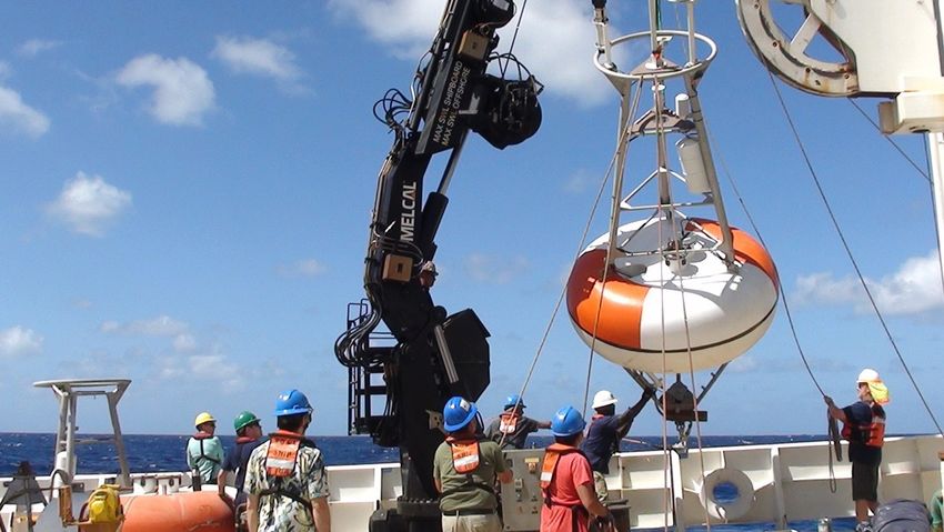
PIRATA Cruise Continues Tropical Atlantic Ocean-Atmosphere Monitoring,
Provides Long-Awaited Refresh of Moorings
AOML and University of Miami-Cooperative Institute researchers
departed Miami Beach, Florida on January 15 for the PIRATA
(Prediction and Research moored Array in the Tropical Atlantic)
Northeast Extension (PNE) cruise. The effort aboard the NOAA
ship Ronald H. Brown was led AOML oceanographer Greg Foltz,
PhD, as Chief Scientist. Diego Ugaz, an AOML-Cooperative
Institute technician, served as the Night Watch Leader. The
successful cruise ended on February 24 with the Brown’s arrival in
Key West, Florida.
PIRATA consists of 18 open-ocean moorings and is a collabora-
tive effort between Brazil, France, and the United States to study
and improve predictability of ocean-atmosphere interactions that
affect regional weather and climate variability on seasonal,
interannual, and longer time scales. PNE is part of the US The Brown’s deck crew, PMEL’s mooring technicians, and AOML volunteers
deploy a PIRATA buoy at 15°N, 38°W.
contribution to PIRATA and is a joint effort between NOAA’s
Pacific Marine Environmental Laboratory (PMEL) and AOML, near-surface concentrations of carbon monoxide, sulfate, and
funded through the Global Ocean Monitoring and Observation ozone throughout the cruise. The data are in support of AEROSE
program. (Aerosols and Ocean Science Expeditions), which has participated
During the 41-day cruise, four PNE buoys and one Brazilian in PNE cruises since 2006 and also involves researchers from
PIRATA mooring were replaced, and one French mooring was NOAA’s National Environmental Satellite, Data, and Information
serviced (see map below). This was by far the longest and most Service (NESDIS), Howard University, and Arizona State
remote cruise on a NOAA ship since the NOAA fleet was called University. AEROSE measurements monitor African dust and
home due to the COVID-19 pandemic. The four PNE moorings smoke emission/transport and their impacts on the environment
were scheduled for replacement in May-June 2020, but that cruise and provide crucial in-situ calibration and validation of satellite
was canceled because of COVID-19. As a result, by the start of the data.
cruise in January 2021 the moorings had been in the water for A new addition to the PNE cruise this year was the Fearless
21‑23 months, far beyond their expected lifetimes of 12-14 months, Fund, a nonprofit organization supported by the US Department of
and in desperate need of replacement. On the return transit to Key Energy, in conjunction with NOAA, to produce macroalgae at an
West, an additional PIRATA mooring in the central tropical North energy (or carbon dioxide removal) scale. The group joined the
Atlantic was deployed. The previous mooring at this site had been cruise to better understand the production system of the macroalgae
deployed by the Brazilians in late 2018 and had since become Sargassum, which has been expanding farther into the tropical
unmoored and lost data transmission. The combination of Atlantic since 2011. The Sargassum team worked with AOML to
COVID-19, an ocean oil spill, and ship mechanical issues had obtain more than 300 near-surface water samples that will be
prevented Brazil from replacing the buoy as originally planned. analyzed for phosphate and nitrate by AOML’s Ocean Chemistry
Sixty-one CTD profiles of the water column, from the ocean and Ecosystems Division. The goal is to improve understanding of
surface to 1500 m depth, were conducted along the ship’s track to the sources of nutrients for Sargassum production in the tropical
gather temperature, salinity, dissolved oxygen, seawater pressure Atlantic. The Sargassum group, in collaboration with AOML and
and density, and velocity data. Twelve Argo floats were also PMEL, also performed a CO2 sequestration test, which involved
deployed. Additionally, a group from Virginia Union University sinking Sargassum biomass to the deep sea (see image below). The
measured vertically-integrated atmospheric aerosol loads and Sargassum will be retrieved during next year’s PNE cruise to
assess its decay rate and potential for CO2 sequestration. AOML,
PMEL, AEROSE, and Fearless Fund look forward to continuing
their joint efforts during the 2022 PNE cruise.
PNE cruise track with starting port (green circle) and end port (red circle). Symbols
show locations of moorings that were recovered, deployed, and serviced, ocean Sargassum was sealed in a container and sent to the bottom of the ocean for a
profiles from CTD casts, nutrient samples, and Argo deployments. CO2 sequestration experiment.
January-March 2021 AOML Keynotes | 7
Drones that Hunt Hurricanes? NOAA Puts Some to the Test
NOAA scientists launched a new
u ncrewed small aircraft—a research
drone—from a NOAA Hurricane Hunter
plane in the clear skies over Maryland
during the week of January 11 to test its
ability to gather weather data that could
improve hurricane forecasts.
“We’re hopeful this new technology,
once it can be successfully tested in a
hurricane environment, will improve our
understanding of the boundary layer to
advance NOAA’s forecast models used to
predict the track and intensity of tropical An Altius-600 uncrewed aircraft is launched from one of NOAA’s P-3 Hurricane Hunter planes. The diminutive
cyclones,” said Joseph Cione, PhD, an drone—only 40 inches in length and weighing 25 pounds—has a cruising range of up to 4 hours.
AOML meteorologist. “Ultimately, these
new observations could help emergency data as they fall to the ocean, recording o ffers new data-gathering features such as
managers make informed decisions on wind speed and direction, temperature, the ability to fly for up to 4 hours and at
evacuations before tropical cyclones make moisture, and pressure as they go. distances of up to 265 miles from its point
landfall.” “Dropsondes give us ‘snapshots’ of of launch. Like dropsondes, however, they
NOAA Corps pilots routinely fly the weather conditions, while the continuous cannot be r ecovered once deployed.
agency’s two P-3 Orion Hurricane Hunter flow of data collected by uncrewed aircraft NOAA Corps test pilots and NOAA
aircraft into the eye of tropical cyclones to provide something closer to a movie,” engineers also coordinated closely with
gather vital weather data. But they avoid said Cione, who conducted the drone test the Naval Air Station Patuxent River’s
the perilous lower eyewall in the boundary missions at Patuxent River Naval Air Atlantic Test Range and the Navy’s
layer where the ocean meets the Station. “Deploying uncrewed aircraft unmanned aircraft test squadron UX-24 to
atmosphere. This violent area of high from NOAA Hurricane Hunters will ulti- successfully execute the test flights, which
winds and towering ocean waves is of key mately help us better detect changes in are required to certify the Altius-600 for
interest to scientists, but it’s too dangerous hurricane intensity and overall structure.” operational use in hurricane conditions.
for piloted aircraft. NOAA worked closely with Area-I, the
Instead, scientists aboard the Hurricane Georgia-based aerospace company that
Hunters release sensors tethered to para- created the Altius-600 drone, to adapt it This article is modified from an online
chutes, known as dropsondes, that gather for sampling weather data. The drone version published at www.noaa.gov
AOML Mourns the Loss of Robert Kohler
“Constant, kind, and always willing to help.” Peter Black
Robert (Bob) Kohler, the director of Computer Networks and Services (CNS) at AOML, died on Sunday,
F ebruary 7, 2021, after a brief battle with colo-rectal cancer. He was 76 years old. Bob led the CNS group
for more than 20 years, supervising a staff of seven IT specialists.
He began his federal career in 1967 with the US Coast and Geodetic Survey (USCGS), spending time at
sea documenting magnetic and tectonic trends and digitizing nautical charts. In 1970 he was sent to Byrd
Station in west Antarctica where he spent 13 months conducting magnetic and seismic ground surveys.
Kohler Dome in Antarctica is named in his honor for the work he performed there. For his numerous
contributions while with the USCGS, Bob was made a Fellow of the American Congress of Surveying and
Mapping/American Association for Geodetic Surveying.
His career switched gears in 1981 when Bob joined AOML’s Hurricane Research Division as a computer programmer analyst. Over
the ensuing years he supported tropical cyclone research, even participating in missions aboard NOAA’s Hurricane Hunter P-3 aircraft
to provide software support and to plot/process data obtained in flight. He was selected to lead CNS in 1999.
Frank Marks, director of the Hurricane Research Division, recalled that “Bob had a wealth of knowledge and experience that
made him an invaluable asset. He brought those same values and strengths to his expanded role in leading CNS through a number
of transitions. Bob understood the scientific process and the role IT played in fostering that process.”
AOML hosted a memorial service for Bob on March 10, 2021 at Tropical Park in Miami. The event brought together friends, family,
and staff, virtually and in person, to commemorate Bob’s life and his many years of service at AOML. Bob’s federal career with the US
Coast and Geodetic Survey and with NOAA spanned 54 years, making him one of AOML’s longest-serving federal employees. He is
survived by Nancy Marshall, his wife of 43 years.
8 | AOML Keynotes January-March 2021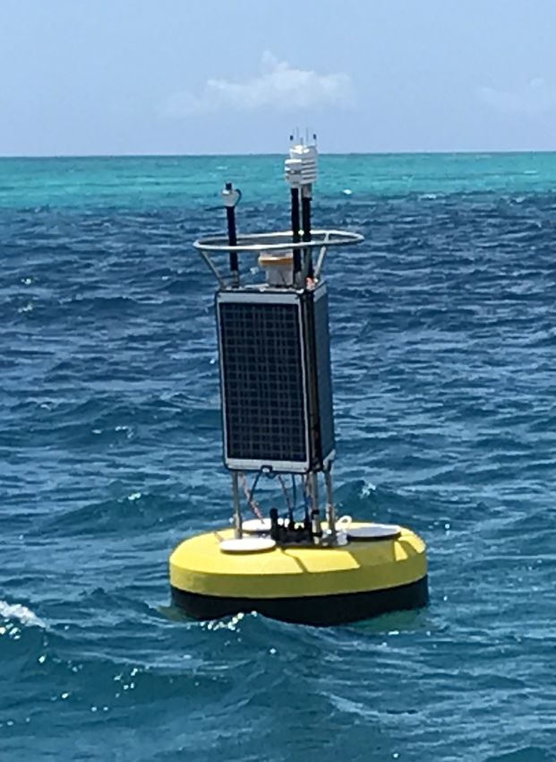
Study Examines how Different Techniques to Model the Hurricane Boundary
Layer Can Improve Forecasts
In a recent study published in the
journal Atmosphere,* hurricane scientists
at AOML examined how turbulent mixing
in the boundary layer affects the intensity
and structure of hurricanes in NOAA’s
Hurricane Weather Research and Forecasting
(HWRF) model. They found that turbulent
mixing affects where thunderstorms in
hurricanes occur and how fast air flows
towards the center of a storm.
Knowing what is happening in the
atmosphere immediately above the ocean,
an area called the boundary layer, is vital
for predicting hurricane intensity. While
hurricanes can measure hundreds of miles
across, the strongest winds usually occur
in gusts smaller than 100 yards across,
what is known as the turbulent scale. The
swirling flow associated with this small
area is called turbulent mixing, which is
especially important in the boundary
layer, as it can transport heat and moisture
from the ocean below to the storm above.
However, turbulent-scale features are
too small for HWRF and other models to
capture; instead, scientists use parameter-
ization to estimate the strength of turbulent
mixing. Parameterization is a method used
to represent the small-scale processes that Two images that show hurricane structure differences in the region closest to the storm center due to changes
can’t be resolved by models. This study in the vertical eddy diffusivity. RMW represents the radius of maximum wind speed, or the eyewall. Light blue
arrows show radial flow, while dark blue arrows show updrafts and convection. The region below the green
reviewed the impact of planetary boundary line is the boundary layer. When eddy diffusivity is small, both the strongest winds and thunderstorms tend to
layer parameterization schemes that have be located closer to the storm center.
been used in the operational version of
HWRF since 2011. in using observations from the unique known as the radial flow, as well as the
“The horizontal grid spacing of a hurri- platform of Hurricane Hunter aircraft to height of the boundary layer. This inflow
cane forecast model is usually larger than improve the representation of fundamental feeds energy from the ocean into the
1 km, but the scales of turbulent eddies physical processes in hurricane models,” hurricane’s core. When the vertical eddy
can be as small as 10 m,” said Jun Zhang, said AOML meteorologist and study diffusivity is small, the radial inflow is
PhD, a Cooperative Institute hurricane coauthor Robert Rogers. strong, and the boundary layer is shallow.
scientist at AOML. “This parameter is very important for These findings emphasize the importance
In this study, the HWRF model was run hurricane intensity forecasts,” said Zhang. of model physics on hurricane intensity
multiple times using five types of parame- When vertical eddy diffusivity is large, and structure forecasts and will guide
terization to determine which forecasts more turbulent mixing occurs. When it is model developers to further improve
were closest to the observations obtained small, less turbulent mixing occurs, and hurricane forecast models. Such improve-
from NOAA’s Hurricane Hunter aircraft. the strongest winds in the model are closer ments have the potential to save lives,
Scientists then looked at how and why to the center of the storm. reduce property damage, and increase the
different boundary layer parameterization Scientists also determined that turbu- public’s confidence in NOAA’s official
schemes produced different forecasts in lent mixing affects where thunderstorms hurricane forecasts and warnings.
the HWRF model. are located in hurricanes. When vertical
Turbulent mixing is controlled by a eddy diffusivity is small, the strongest
parameter called the vertical eddy thunderstorms in a hurricane tend to be *Zhang, J.A., E.A. Kalina, M.K. Biswas, R.F.
diffusivity. According to Zhang, the located closer to the center of the storm Rogers, P. Zhu, and F.D. Marks, 2020: A
vertical eddy diffusivity is a parameter in and farther inside the eyewall where the review and evaluation of planetary boundary
the forecast model that describes the fastest winds occur. layer parameterizations in Hurricane Weather
Research and Forecasting model using
strength of vertical mixing by the small- Turbulent mixing can also impact how idealized simulations and observations.
scale rotating flow in the atmosphere. fast air flows towards the center of a hurri- Atmosphere, 11(10):1091, https://doi.org/
“This study shows the tremendous value cane near the ocean surface, otherwise 10.3390/atmos11101091.
January-March 2021 AOML Keynotes | 9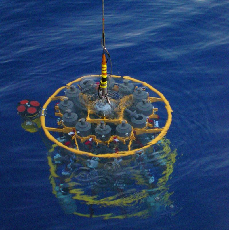
Scientists at AOML Facilitate Leap in Hurricane Modeling and Prediction Systems
Scientists at AOML have created a new,
advanced moving nest model within the
Unified Forecast System, the bedrock of
NOAA’s weather prediction applications.
AOML’s Hurricane Modeling Group
developed the high resolution model for
the FV3 dynamical core, laying the
foundation for the next generation of
advancements in hurricane forecasting.
The Hurricane Analysis and Forecast
System (HAFS) is NOAA’s next-genera-
tion numerical model and data assimilation
system, which is being developed within
the framework of the Unified Forecast
System. Central to the improvement of
HAFS has been the goal of adding an
embedded moving nest to the FV3
dynamical core, enabling scientists to
track the inner core region of tropical
cyclones at 1-2 km resolution.
“The creation of the moving nest model
capability is a key milestone in the
development of the next generation
Hurricane Analysis and Forecast System,”
said Frank Marks, PhD, the director of
hurricane research at AOML.
Scientists at AOML partnered with
colleagues at NOAA’s Environmental
Modeling Center and NOAA’s Geophysical
Fluid Dynamics Laboratory during the Hurricane Laura (2020) as depicted by the Hurricane Forecast and Analysis System (HAFS) model prior
overactive 2020 Atlantic hurricane season to landfall along the Louisiana coast as a powerful Category-4 hurricane. HAFS accurately predicted
to test and evaluate the HAFS in real-time. Laura’s track, structure, and intensity.
Two models were configured within the
framework of the 2020 Hurricane Forecast with multiple storm-following nests that track, intensity, and storm surge forecasts.
Improvement Project for testing purposes. allow hurricane forecasters to simultane- Since the project began in 2009, HWRF
The first model was a version of HAFS ously track multiple tropical cyclones. track errors have been reduced by about
with a high resolution static nest embedded The HWRF model has demonstrated a 30% and intensity forecast errors by about
within a global domain. The second model remarkable improvement as a result of the 25%. The HWRF model has additionally
was a version of the Hurricane Weather Hurricane Forecast Improvement Project, demonstrated a near 10% improvement in
Research and Forecasting (HWRF) system which aims to reduce errors in hurricane hurricane intensity forecast accuracy
annually since 2011.
“We are now developing a system that
will surpass the HWRF system,” said lead
scientist for the Hurricane Modeling
Group and chief architect of the HWRF
model, Sundararaman Gopalakrishnan,
PhD. “We’re moving from one generation
to the next.”
The advancements in these models will
improve forecasting skill by increasing the
accuracy of NOAA’s extended forecasts
and the extent of evacuation areas, especially
on 5-7 day timescales, well before tropical
cyclones make landfall. This research
transition will greatly benefit emergency
managers by providing information that
will improve the quality of their planning
After cutting a path of destruction across the Caribbean, Hurricane Laura came ashore in Cameron, Louisiana efforts, ultimately saving lives and reducing
on August 27, 2020 with 150 mph sustained winds and a 15-foot storm surge. property damages.
10 | AOML Keynotes January-March 2021Researchers Solve an eDNA Mystery
AOML Cooperative Institute Associate Research Professor Luke Thompson and Cooperative
Institute Post-Doctoral Associate Sean Anderson have been analyzing seawater at the University of
Miami dock across the street from AOML for the environmental DNA left behind by fish. While many
of the fish species detected were expected for the area, a few unexpected species such as rainbow
trout, a native of the North Pacific Ocean, came as quite a surprise. To help solve this mystery,
surveys were sent to fish biologists with expertise of the South Florida region. More than 20 survey
responses from expert “a-fish-ionados” shared their knowledge, and based on this expert feedback
and Luke and Sean’s research, 31 of the top 40 most abundant fish sequences could be accounted
for as native to South Florida waters at the genus level or lowest assigned level.
For non-native sequences, including the abundant sequence assigned as Oncorhynchus mykiss
(rainbow trout), many respondents surmised its DNA could be from fish parts being dumped nearby,
with several mentioning the Miami Seaquarium next door to the University of Miami. It was
subsequently confirmed by the curator of the Seaquarium that leftover parts from three feed
fishes—Oncorhynchus mykiss, Clupea harengus (herring), and members of Osmeridae (capelins and
smelts)—were dumped nightly into the water, which were among the most abundant sequences
observed, respectively. Two other non-native sequences, assigned to Ammodytes spp. (sand lance),
may derive from common bait fish associated with fishing activities around Bear Cut on Virginia Key.
Mystery solved...case closed! Sean Anderson at the University of Miami dock.
New Hurricane Ocean Profilers Tested Ahead ofDeployment
during 2021 Hurricane Season
AOML partnered with NOAA’s Aircraft Operations Center in January 2021
to complete testing of the Air-Launched Autonomous Micro-Observer
(ALAMO) profiling float. This testing cleared the ALAMO float for
deployment from NOAA’s P-3 Hurricane Hunter aircraft, marking the first
time the floats will be used during hurricane reconnaissance missions.
Because the ocean plays a critical role in fueling hurricanes, a better
understanding is needed of how ocean conditions impact hurricane
intensity. The most direct way to reduce this uncertainty is to gather An ALAMO profiling float is deployed from a NOAA P-3 Hurricane Hunter
aircraft.
targeted upper-ocean measurements before and during the passage of
tropical cyclones.
Once deployed, ALAMO profiling floats measure temperature, salinity, and pressure in the upper 300 m of the ocean, generating profiles every
1-2 hours for several weeks. The data are automatically processed and posted to the Global Telecommunication System for use by the operational
community to improve the ocean’s representation in ocean-atmosphere coupled forecast models. By deploying these uncrewed systems, AOML
scientists will gain insight into how the ocean drives hurricanes, targeting storms that threaten landfall in regions with strong salinity or shallow
temperature stratifications. These data can then be used in hurricane research models to reduce intensity forecast error.
AOML Brings New Technology to Fishery Surveys
Cooperative Institute Postdoctoral Associate Sean Anderson participated in a NOAA
Fisheries cruise aboard the NOAA Ship Pisces from March to May to improve
ecosystem-based fisheries management through the use of environmental DNA
(eDNA) sequencing. Camera traps were placed on the seafloor in the Gulf of Mexico
to capture video of passing fish, while bottles collected seawater from areas where
the fish passed through, leaving behind traces of their DNA. The seawater was
subsequently filtered, with DNA extracted, sequenced, and analyzed. This new
technology will help increase the understanding of how eDNA detection of fishery
species correlates with direct measurements of these species by camera traps. It will Sean Anderson processes samples for eDNA aboard the
NOAA Ship Pisces.
also help improve the understanding of fish distributions in the Gulf of Mexico and
enhance understanding through the modeling of these distributions. The survey was conducted in support of the Southeast Area Monitoring and
Assessment Program (SEAMAP), a state-federal-university program that collects, manages, and disseminates fishery-independent data and
information in the southeastern US. SEAMAP is jointly led by AOML, NOAA’s Southeast Fisheries Science Center, and the Universtiy of West Florida.
January-March 2021 AOML Keynotes | 11Virtual Meetings Focus on Collaboration with Partners, Next Steps
AOML leaders and principal investigators helped organize and participate in three science workshops in January and February, capitalizing
on the v irtual environment to identify areas for collaborative research with partners and exploring next steps.
January 26-28: AOML collaborated with NOAA’s Global Ocean Monitoring and
bserving Program and the US Integrated Ocean Observing System to host the
O
Integrating Ocean Observations to Improve Hurricane Intensity Forecasts Workshop.
The 3-day event brought together federal and academic partners to focus on upper
ocean/air-sea boundary layer observing, analysis, and modeling efforts in support of
hurricane intensity science and forecasting.
Participants were tasked with addressing how NOAA could improve the
integration, coordination, and communication of its ocean observing and modeling
activities as they relate to forecasting hurricane intensity. Presentations and
discussions explored how to improve the state of NOAA’s hurricane intensity
forecasting system, as well as how to best close gaps in NOAA’s observational efforts
of the upper ocean and air-sea boundary layer based on current and future observing
capabilities.
The workshop was well attended, with more than 100 participants daily from
NOAA’s National Weather Service, Office of Marine and Aviation Operations, and
Office of Oceanic and Atmospheric Research. External partners, included, among
others, Rutgers University, the US Navy, University of Washington, and Naval
Research Laboratory.
February 2: AOML scientists joined colleagues with NOAA’s Center for Satellite
Applications and Research (STAR) for a 1-day workshop to share research priorities,
goals, and objectives. Leaders and principal investigators from AOML and STAR
jointly discussed how to enhance their current collaborations and develop new
opportunities for future collaboration.
The workshop featured three breakout sessions focused on hurricane research,
physical oceanography, and ocean chemistry/ecosystems. Each session featured
presentations by STAR and AOML scientists, followed by a discussion to identify
research areas of interest and potential synergy. For example, during the ocean
chemistry/ecosystems session, participants noted that ecological forecasting and
ocean heat content were two areas for mutually beneficial research. A findings
report is being generated with potential actions, while a “roadmap” is being developed
to serve as a platform for successful interactions and collaborations in the future.
February 23-25: The National Centers for Coastal Ocean Science (NCCOS) of
NOAA’s National Ocean Service and AOML hosted a joint workshop to increase
awareness and knowledge of NCCOS and AOML activities, as well as identify
opportunities for future collaboration and next steps. Following introductory
comments and background information by NCCOS Director Dr. Steve Thur and AOML
Director Dr. John Cortinas, participants attended 2-hour breakout sessions.
Over the span of 3 days and nine sessions, principal investigators from both
institutions gave presentations on a wide range of research topics, including coral
reef research, harmful algal blooms-hypoxia-pathogens, integrated ecosystem
assessment and ecosystem restoration, pollution, edna and ‘omics, climate and
extreme weather, ocean acidification impacts on coastal ecosystems, uncrewed
systems,
advanced sampling technologies, physical modeling, and ecosystem
modeling/forecasting. Discussions folllowed every session to explore areas for
collaborative research, current capabilities, resources, funding, and next steps. In
total, more than 70 NCCOS and AOML principal investigators participated.
12 | AOML Keynotes January-March 2021Spotlight On!
AOML is pleased for two of its scientists to have been recently recognized for their accomplishments: Oceanographer Evan Forde was
ighlighted by the Department of Commerce in honor of Black History Month, while oceanographer Renellys Perez was highlighted by
h
NOAA’s Office of Oceanic and Atmospheric Research in honor of Women’s History Month. Here are their stories:
I grew up in Miami, Florida, and What drew you to your current
attended Miami-Dade County public career? My love of math and physics,
schools. I earned a bachelor’s degree fondness for the ocean, and desire to
in Geology (with an oceanography study observable phenomena (even if
specialty) and a master’s degree in you need a satellite to o bserve it).
Marine Geology and Geophysics What is your typical day at NOAA
from Columbia University in New like, and how has the pandemic
York City. I am proud of a 46-year changed your typical work day?
career as a federal employee, working A typical day involves attending
hard as a career civil servant on behalf meetings, working on new research
of the American people each day. To me, the phrase “good enough ideas, mentoring the early career scientists I work with, exchanging
for government work” challenges me to do my job even better and ideas with colleagues, answering emails, and planning for future
more than anyone could reasonably expect. research cruises. The pandemic has removed the face-to-face
I would tell youth interested in a government career that federal interactions but has given me opportunities to virtually participate
employment is rewarding and has many benefits. Employment in in meetings and workshops I wouldn’t normally be able to attend.
the federal government is protected by laws that uphold workers’ Planning future research missions 6 months to a year in advance
rights and promote fairness. I have never served my country in our involves a lot of moving parts, and planning cruises during the
military, but I often remind myself that each workday I am serving pandemic adds more c omplexity and uncertainty.
my fellow citizens, and that always brings a smile to my face. What do you hope to accomplish in the future? What do you
In my personal time, I strive to foster youth development and hope the future for women in science looks like? My hope for the
improve my community. I have served as a PTA president, a future is that our NOAA workforce looks like our country, and that
scoutmaster, youth basketball coach, Sunday school and youth underrepresented groups in science and leadership no longer lack
church teacher, church webmaster, neighborhood Crime Watch sufficient representation.
chairman, HOA vice president, board of directors member for a
Boys and Girls Club, and in numerous other roles that have Have any opportunities opened up by the change to virtual-only
strengthened my community and me as a person. work? Yes, I have participated in NOAA mentoring, virtual NOAA
My father was my greatest mentor. When I was troubled or leadership training courses, and the Latinos@NOAA Employee
struggling in life, my dad would sometimes remind me of this Resource Group. I probably wouldn’t have participated in some of
quote from the poem “If” by Rudyard Kipling: these activities prior to teleworking. I sought out these opportunities
to feel more connected to NOAA while teleworking. I have enjoyed
“If you can fill the unforgiving minute being part of discussions of diversity with AOML’s Diversity
With sixty seconds’ worth of distance run, Inclusion & You (DIY) group in a pivotal time in our history,
Yours is the Earth and everything that’s in it, organizing conferences that are 100 percent virtual to continue
And—which is more—you’ll be a man, my son!” doing science during this time, and participating in virtual outreach
for K-12 students.
This quote always makes me want to do my very best and give Has your idea or definition of success changed in the past year?
all I’ve got to every challenge. As I reflect during Black History I have a kinder definition of success that I learned from parenting
Month, I am more aware of black Americans’ substantial during the pandemic: am I learning, am I growing, am I showing
contributions to our country and to mankind. This enhanced up, am I doing my best in this challenging time?
awareness not only helps to create a sense of pride in me but also What gives you hope, either with regard to science, your field in
inspires me to be an inspiration to others. NOAA, or in general? My colleagues were able to complete a
Evan Forde is an oceanographer with AOML’s Computer 40‑day research cruise on the NOAA Ship Ronald H. Brown in
etworks and Services group. His work is currently focused on
N January-February safely and successfully thanks to shelter-in-place
several areas of scientific research, including the analysis of protocols. As more and more of us get vaccinated, I am hopeful
satellite sensor data and identification of critical atmospheric
that it will become easier to achieve those aspects of our NOAA
conditions related to hurricane formation and intensification. A mission that the pandemic has made challenging.
portion of Evan’s work responsibilities a lso involves assisting the Dr. Renellys Perez is an oceanographer who co-leads AOML’s
AOML computer systems administrator with networked computing contribution to the Prediction and Research Moored Array in the
risk assessment and threat mitigation. Evan additionally creates Tropical Atlantic (PIRATA) Northeast Extension project and leads
contingency plans and training exercises to ensure the r esiliency of the Southwest Atlantic Meridional Overturning Circulation (SAM)
AOML’s essential computing elements. project, both funded by NOAA’s Global Ocean Monitoring and
Observing Program.
Note: Evan’s guest blog post of February 22 was part of the Spotlight
on Commerce series highlighting the contributions of Department Note: The complete profile for Renellys can be found online at
of Commerce African Americans during Black H istory Month. https://research.noaa.gov/News/Scientist-Profile.
January-March 2021 AOML Keynotes | 13You can also read