An Ancient Landscape Shaped by the River: The Impact of the Adige at the Base of the Alps. A New Research Perspective
←
→
Page content transcription
If your browser does not render page correctly, please read the page content below
An Ancient Landscape Shaped by the River:
            The Impact of the Adige at the Base of the Alps.
                    A New Research Perspective

                                                Annapaola Mosca

The goal of this study is to analyze the impact of the upper section of the Adige at the
base of the Alps on the ancient landscape and the economy with a focus on the Roman
Age.1

                  The Settlement Pattern in the Adige Valley in Antiquity

How was the ancient course of the Adige river? It was very different from the current
one and it must have influenced the settlement pattern in the entire valley. The river
was probably larger and characterized by meanders, as we can see through aerial
photographs and as ancient settlements seem to demonstrate. It is sometimes difficult
to imagine environmental situations that have helped to define the ancient settlement
organization, much more linked to the Adige river than today. Not only the Adige but
also its tributaries have changed their course over the centuries, up to major changes
between the 19th and the 20th century.2 But only maps of the 19th century can attest with
more precision how the Adige was before the adjustments and the construction of the
railway in the second half of the19th century (1867).3
   The river seems to have already influenced settlement patterns in pre-Roman periods.
For example, if we consider the pre-Roman sites from south to north in the middle
Val Lagarina, Castel Tierno, Castel Pradaglia (right bank) and Dosso Alto near Borgo
Sacco (left bank) in the Bronze Age, we will see that they were located to control the
Adige river south of Rovereto4 while Nomi Cef (right bank) was in a marsh, along the
river, south of the modern town of Rovereto in a strategic position, as perhaps the river
was a commercial way, but also the river itself or the valley bottom could have been
practicable by enemies.5 Other settlements had the function of controlling the Adige
Valley too, for example some sites scattered above the hills near the modern town of
Trento6 and “Dosson di Faedo”.7 Vadena/Pfatten between the modern cities of Trento
and Bolzano was recognized as a commercial emporium on the river Adige.8
   The Adige Valley has been used as a commercial route from the Adriatic ports since
the pre-Roman period. Different data suggest that goods could arrive directly from the
Adriatic ports but neither remains of pre-Roman or Roman boats nor ancient harbors
have been identified so far in the upper part of the river. Moreover, the ancient written
sources do not mention the practice of navigation along the Adige at the base of the
Alps. It was assumed that from the end of the 6th until the early 4th century BC the wine,
which arrived inside Greek amphorae via transmarine trade, was poured into wooden
Published in: Eurydice Kefalidou (Ed.), The Riverlands of Aegean Thrace: Production, Consumption and Exploitation of the
Natural and Cultural Landscapes / River Valleys and Regional Economies, Panel 2.4 / 2.7, Archaeology and Economy in the
Ancient World 6 (Heidelberg, Propylaeum 2022) 71–86. DOI: https://doi.org/10.11588/propylaeum.871.c11427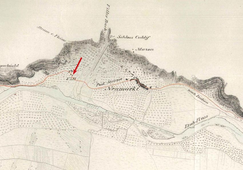
72                     Annapaola Mosca

     Fig. 1: Location of the Ponte Gardena / Waidbruck statio.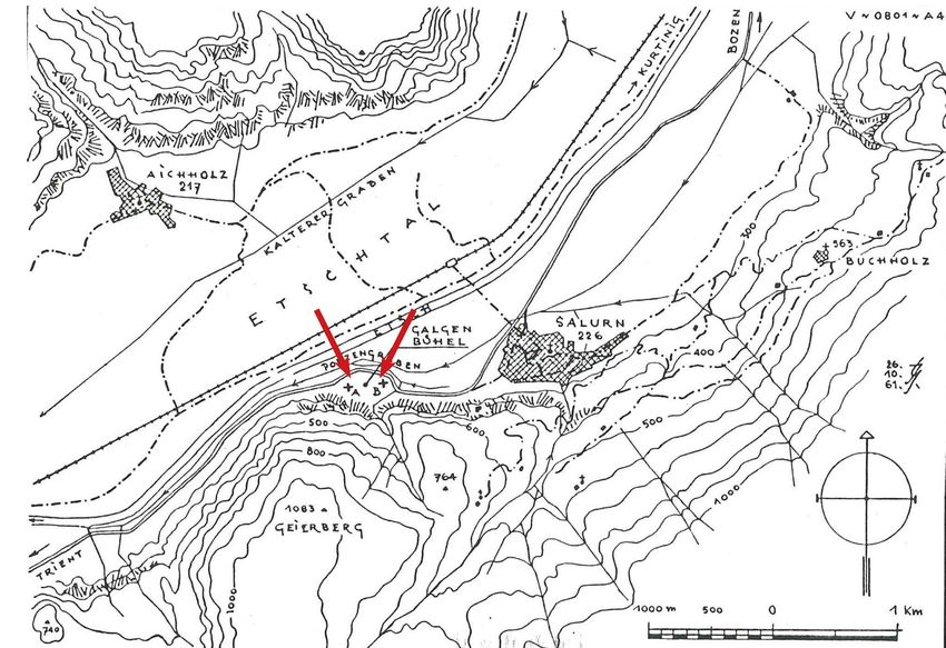
An Ancient Landscape Shaped by the River                           73

barrels to be transported in the Alpine valleys. This theory was based on the fact that in
the area of Mantua (Forcello), which was a sort of strategic hub where the waterways
met the paths from the Appennines and the paths and the waterways from the Alps,
many amphorae from the Aegean area have been found.9
   Several archaeological artefacts have shown a close relationship with the northern
Adriatic area. This was demonstrated in the past with the discovery of artefacts from
the Northern Adriatic area in Vadena/Pfatten along the Adige course.10 The discovery in
Settequerce/Siebeneich, in the Terlano/Terlan area, along the ancient course of the Adige
river, of an Iron Age settlement with a place dedicated to worship with pottery artefacts
of 5th–4th century BC very similar to those discovered in Este, led to the presumption of
a direct connection with the Adriatic ports; the importance of the port of Adria in the
Northern Adriatic area has been revalued, in connection to the possibility of transport
along the river Adige.11
   In the last period of the Roman Republic, exchanges between the population living at
the base of the Alps and the Roman world increased, as we can deduce above all from
the coins found in some settlements, for example in Laives/Leifers, along the river.12
Probable drainage works made by stones along the Adige Valley, at the current state
of research have been identified in Laives/Leifers dating back to the 4th century BC and
prove that the Adige tended to overflow towards the settlement located on the conoids
and in Vadena/Pfatten.13 Here we can believe that this arrangement of pre-Roman
settlements makes clear the close link with the river, since the settlements needed to be
located near the river and not in a safer position.

             The Impact between Local Populations and the Romans

This area, mainly connected to the Roman town of Tridentum, is generally supposed
to have become part of the Roman world in the early Imperial period. We have a few
literary sources about this territory in the first Roman Imperial era.
    Perhaps the war between the Romans and the local population at the base of the Alps
was not so bloody as reported by Horace.14 Archaeological data indeed seem to suggest
a gradual transition as shown by the flow of goods from the Mediterranean area15 and as
evidenced by the archaeological excavations in the current state of research.16 The Alps
did not mark the border of Italy as today but the border of the Italic regions of Augustus
had to be on the southern base of the Alps.17
    The reorganization of the territories at the base of the Alps led to the creation and
strengthening of the urban center of Tridentum that probably played a decisive role
already in the phases of the Roman conquest and must have taken place over several
years, as attested by the milestone found in Val Venosta/Vintschgau, and by the edict
of Claudius found in Val di Non.18 When, during the 1st century AD, the emperors of
the Flavian dynasty and their successors extended the fortifications along the limes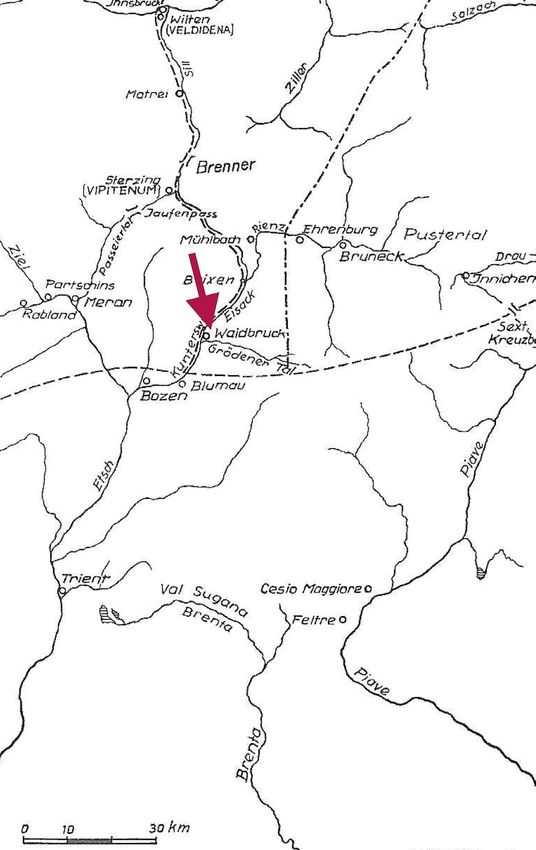
74                                 Annapaola Mosca

                  Fig. 2: Location of the Roman necropolis of Salorno.

of Germania and Raetia, the district became more intensely a territory of passage of
armies and traders, but the archaeological data show that the district kept its own
characteristics.19

                          Reorganization of the Settlement

For the Roman reorganization of the settlement, the river must have played an
important role, as the city of Tridentum, probably founded in the second half of the
1st century BC20, was built in close connection to the river and in the age of Augustus
became the main center (municipium) of this district,21 as we can deduce from the
monumental remains of the Roman town, even if a Roman port has not yet been
identified.22
    The roads with their stations (stationes) together with the rivers marked the boundaries
between the Italian territory and the neighboring provinces. Near the borders the
custom stations have been set up. These stationes are mentioned in epigraphic sources;
but these sources are later than the period when the duty stations may have been placed
in key positions.23 One has been identified in the area of Tel/Töll (which refers to the
word Telonium) and was identified as statio Miensis.24 The other one must have been
An Ancient Landscape Shaped by the River 75
located in the area of Colma/Kolmann – Ponte Gardena /Waidbruck along the course of
the Isarco, a tributary of the Adige river, and on the main road that led to the Brenner
pass, presumably already in the territory of the Noricum (fig. 1). This was the custom
statio included in the district of the Publicum Portorium Illyrici.25
Local people were probably living in typical houses (built by wood and local stones
without mortar), while artefacts had to come more massively from the Roman world, as
has been noted in Settequerce/Siebeneich, along the upper river course.26 Villages had
necessarily been rebuilt in the same place closely connected to the river, e.g. Laives/
Leivers, on the left bank of the river, 27 probably where it was possible to cross the
Adige; indeed, in Vaden/Pfatten, on the right bank of the river in front of Laives, a
continuous settlement is attested.28
Only some buildings are distinguished as they were built with the use of lime mortar
and with Roman imperial tiles. From north to south, on the left bank of the Adige, for
example in Laives/Leifers – San Giacomo/St. Jakob, in a building built in the early Roman
Imperial period, Roman tegulae (also with stamps) were found used in foundations;
their purpose was probably to limit water infiltration since the building was in a marshy
area near the river. This building had a short life, as it was destroyed by the flooding
of the river. Judging from the recovered artefacts it had to be important and it was
connected to a road and to the river 29. In another building (1st–3rd century AD), identified
as a mansio, many tiles have been found with a variant of AVRESIS stamp (fig. 3).30
In Laghetti/Laag, in close contact with the river, there were buildings of considerable
importance (1st–6th century AD). Excavations have led to recognize tiles with stamps
AVRESIS, LOCEIAVRESIS and CRVT with variants and tubuli for the heating system.
Artefacts from medium to large scale trade (Italic terra sigillata; amphorae similar to
Dressel 6 B, but also sigillata and glass from the Rhine area and African red slip ware)
have been identified in these buildings.31
In Villa/Vill of Egna/Neumarkt (left bank of the Adige (fig. 5), in the 1st century AD,
a man who was linked to the Roman culture, judging by the choice of the iconographic
motifs of his funerary stele, even if performed by a rough craftsman, had to inhabit
there with his family (fig. 4); in the same village, late Roman republican denarii and
imperial coins were recovered;32 also, in the area around the medieval church of the
modern village ancient artefacts are still reused.
Some villages located not far from the river have become important in the 2nd century
AD, probably in relation to the importance acquired by the district that is increasingly
functional to the needs of the limes. For example, in the 2nd century AD the village of
Mezzocorona Giontec became more articulate;33 it is located on the right Adige not far
from a part of the valley where the Adige river created a swamp. South of the modern
village of Salorno/Salurn an extensive necropolis (1st–4th century AD) was on the left
bank of Adige (fig. 2). The graves were presumably aligned along a road parallel to
the river. Most of the tombs were from the 2nd century AD, as witnessed by the coins
recovered inside them.3476 Annapaola Mosca
Fig. 3: The area of Egna-Khan.
The territory would seem to become progressively more functional to the needs
of the limes, as it is probably shown by an inscription recovered in Tridentum that
recalls the activity of an important man, Gaius Valerius Marianus (end 2nd century
AD – 3rd century AD).35 This region suffered a period of crisis in the 3rd century AD,
generally related to the arrival of Alemanni. Military control over this territory
could have been strengthened. Moreover, the impact of a destructive earthquake
seems to have added to the political and economic crisis.36An Ancient Landscape Shaped by the River 77
Fig. 4: The stele found in Villa/Vill.
The archaeological data of Laghetti /Laag seem to suggest a change of use during the
4 century AD, due to the abundant presence of militaria, in the valleys closely linked
th
to the Adige, prestigious residences were created.37 In 357 AD Constance II passes from
Tridentum to reach the Danube limes.38 The pressure of the Goths of Alaric (402 AD)
and of the Ostrogoths of Radagaisus (405 AD) seems to have determined a situation of
instability, but not the end of the settlement organization along the course of the Adige.78 Annapaola Mosca
Fig. 5: Location of the area of Villa/Vill.
Economy and Activities Connected with the Settlement
We do not have written sources on productive activities along the Adige Valley, but
it is possible to reconstruct the local economy through various data. There must have
certainly been a trade in food (especially milk derivates and meat too), but it is difficult
to recognize their trade system because they must have been kept in wooden or wicker
containers. Through the ethnographic tradition we can imagine that the flow of wood
along the course of the Adige could have been practiced and that, perhaps, as attested
from the Middle Ages onwards, saw mills should have been present where the streams
entered the Adige.39 A Roman relief of Attis found in Trento could be connected with a
collegium of dendrophoroi.40
The wool craftsmanship had to be widespread, as attested by the loom weights dated
back in Roman age spread throughout the territory. Through ethnographic tradition
we can imagine flocks of sheep that passed along the Adige valley from the Alps to the
plain and vice versa.
Most of the houses were built with local stones and wood. One of the main activities
was to work with the stone, practiced above all in Tridentum, where ancient quarries on
the eastern hills are attested. Many artefacts were created in Roman times (from the 1stAn Ancient Landscape Shaped by the River 79
century BC onwards) in local stones (“Marble of Pilo “or “Rosso di Trento”): small altars;
sarcophagi, columns, capitals, but also slabs, polygonal blocks for paving roads and for
milestones. In the upper part of the Adige Valley the porphyry had to be worked; it was
used to create small grain mills.41
We know that tegulae with the stamp AVRESIS and variants42 are widespread
throughout the Adige river. This stamp was found in contexts dating back to the early
Imperial age: for example, in Tridentum at “porta Veronensis” dated, in the current state
of research, in the age of Claudius, and in another building, in a context dated back
between the age of Augustus and the Flavian age.43 A large sorting warehouse of these
artefacts was seen in Ora/Auer area (Unterberg/Sottomonte) in the first half of the 20th
century, but the kilns have not yet found, although many clues seem to identify the Ora/
Auer as a production center.44 As the stamp appears in buildings that seem connected
to central power (“porta Veronensis” in Tridentum) or in buildings connected with roads
and drainage works (for example, the building identified as a road station in Egna Khan
and the one of Laives/Leifers – San Giacomo/ St. Jakob) we could here hypothesize a
production of tegulae controlled by the central power.
The stamp Caius Rutilius (with variants) is also well documented. The most ancient
specimens appear in a building of Laives/Leifers San Giacomo/St. Jakob dated in the
first half of the 1st century AD. The findings of tiles bearing this stamp are mainly
concentrated in the area between Verona and the modern town of Bolzano.45 It is perhaps
possible to hypothesize that brick products of gens Critonia arrived as far as Adige
Valley from the workshops located in the district of Ravenna or in the Padua area.46
From the north Adriatic area came the brick tiles with the stamp Pansiana widespread
from the mid-1st century AD to 79 AD.47
A workshop of clay products (tiles and loom weights) was located at higher altitude,
as that one in Prà de Rover near Cei in Val Lagarina (4th–5th century AD), south of
Tridentum48. In Prà de Rover (about 900 m over sea level) there were clay pits, the
possibility of water supply, large areas for processing and timber for baking ovens.
North of Tridentum, in Cortaccia/Kurtatsch and in Predonico along a side street that
becomes more and more important in Late Antiquity, some kilns have been identified
but, at the current state of research, no stamp can be associated without doubt. In
Cortaccia/Kurtatsch stamps with three circles have also been identified.
Conclusions
Numerous data suggest that River Adige influenced the organization of the settlement
and the productive landscape of the district. If we examine the distribution of pre-
Roman and Roman sites placed in the Adige Valley, it becomes clear that many sites
were located along the river and that the presence of marshes and the danger of damage
caused by floods forced the choice of conoids as settlement sites. It is also evident that80 Annapaola Mosca
many sites were placed in control of the river and of the valley, as river and valley, if
on the one hand facilitated the possibility of trade, on the other hand represented a
dangerous location.
The plantations are supposed to be mainly relegated to hilly slopes or to a few areas
of the valley floor sheltered from floods, instead of expanding upon the whole valley, as
nowadays. Consequently, in the Roman era a large part of the Adige Valley, is supposed
to have had a typical vegetation of a wet environment; only sites protected from the river
floods could be used for agricultural practices. In fact, stone presses for grapes have been
noticed in the hilly area facing the Adige Valley (for example in Cortaccia/Kurtatsch).
The presence of the urban center of Tridentum linked to the river, the attestation
of Roman stations on the valley floor, the settlement continuity of several sites along
the river, the presence of Roman coins and of people who choose iconographic motifs
typical of the Roman world in their stelae, the trade of terra sigillata and of other goods
from the Mediterranean area, the circulation of heavy tiles that contributed to the
creation of new buildings, they are all elements that make us realize that the river, with
the road-system, must have been an aggregating element in the territory.
Notes
1
From north to south: Adige Valley from the area of the modern center of Merano/Meran as far as the
southern outskirts of Trento and Val Lagarina as far as the area of the modern town of Rovereto.
2
About morphodynamics, see Angelucci 2016.
3
See the “carta Claricini” dated between 1845–1850, probably in 1847 (Ranzi – Werth 2016).
4
Battisti 2010, 11.
5
Marzatico et al. 2010, 283.
6
Marzatico et al. 2010, 283.
7
Nicolis 2010.
8
Zanforli – Tecchiati 2010, 615 f. with previous bibliography; see also Alberti 2015.
9
The remarkable findings of amphorae coming from the Aegean area (end of 6th century – beginning of the
4th century BC) carried out at Forcello near Mantua (De Marinis 1987, 213) led to the hypothesis that the
wine was decanted into wooden containers (Sassatelli 1987, 89 f.), most suitable for mixed transport (water-
ways and paths) up to the innermost places: see Dal Ri – Rizzi 2005, 200–203. Olive oil was carried too.
10
See now Alberti 2015, with previous bibliography.
11
Marzoli – Wiel Marin 2016, 306–314. Cups from the district of Attica (1st half of the 4th century BC) were
found there.
12
Gorini 2000, 208; Marzoli et al. 2016, 209.
13
Zanforlin 2010, 591 (Laives/Leifers); Coltorti 1991, 24 (Vadena /Pfatten).
14
Hor. Carm, 4, 4, 17–18; 4,14. Strabo, who wrote the Geographia by 18 AD, says that the populations in
the Alpine region seem to change following the Augustan conquest, as they were forced to pay taxes and
were controlled directly by the central power (Strabo 4.6.9 C 207).An Ancient Landscape Shaped by the River 81 15 Buonopane 2000, 160 ̶ 166. 16 Marzatico – Endrizzi 2016, 160–162; Marzoli et al. 2016, 208. 17 Clemente – Mosca 2015, 683. See also Steidl 2011. 18 CIL V, 8003; CIL V, 5050. 19 Marcone 1991, passim. 20 Bassi 2016, 175–178. 190. 21 Faoro 2014, 99 ̶ 103. 116. 22 Ciurletti 2014, 21–24 (proposal for the reconstruction of the urban scheme, without a port). However, the identification of a river port is generally problematic (see Chevallier 1968, 90). For the location and the function of two river docks in Trento in the Middle Ages, see Mosca 2009, 460. 23 About the origin of the Quadragesima Galliarum: De Laet 1949, 170; France 1993, 895–927. Publicum Portorium already existed starting from the Republican age; it was then reorganized in the age of Augustus, until in the 2nd century (with Traianus or Adrianus) the management of the portorium was passed by societates to private conductores; Marcus Aurelius had reaffirmed imperial control over customs entrusting them to procuratores (De Laet 1949, 384–388. 403–405). 24 CIL V, 5090 = ILS 1561 = IBR 68 (dated back in 217 or 246 AD); another inscription, even if less clear, would appear to be connected to the statio: see Buchi, 2000, 91 f. In statio Miensis in the 3rd century AD the Quadragesima Galliarum was required, that is to say the tax of one fortieth of the value of the commodity. The tax was due for goods coming from Gauls, but later also from Germany. Here we can suppose that stationes occupied larger area than what was usually considered until now. 25 CIL V, 5079 = IBR 57 (Isis Augusta); CIL V, 5080 = ILS 1859 = IBR 58 (Isis Myrionyma); CIL V5081 = ILS 3160 = IBR 59 (a slave Mercurialis works as vilicus). These inscriptions seem to date back in the late 2nd century AD: see Buchi 2000, 91. 26 Marzoli et al. 2016, 209. 27 Marzoli et al. 2016, 211. 28 Marzoli et al. 2016, 212: in the necropolis so far identified, most of the artefacts date back to the late Roman empire. 29 Marzoli – Rizzi 2005. 30 Di Stefano 2002. 31 Dal Ri – Fusi 1997, 94–104. 32 Paci 2002, 146 f.; Alberti 2002. 33 Bassetti et al. 2004, 330. 34 The excavations had been carried out at the end of the 19th century; the data were published in the 20th century (Noll 1963). 35 CIL V, 5036 = ILS 5016 (end 2nd century AD/ 3rd century AD; see Buchi 2000, 81–83). This man was a patronus of Tridentum. Probably he was in charge of the procurements of the legio III Italica (established in 165–166 AD) allocated to the Castra Regina (Regensburg); or he was responsible for collecting the tax (annona) intended to maintain the legio III Italica. 36 The building-statio of Endidae was destroyed by an earthquake in the 3rd century AD: see Galli ̶ Galadini 2002. 37 Marzoli et al. 2015.
82                                         Annapaola Mosca

38
   Amm XVI, 10 ̶ 20.
39
   A production plant operating by water, connected to the presence of running water, has been identified
e.g. in Mezzocorona-Giontec (Bassetti et al. 2004, 330). However, it could also be connected to a smith
workshop or be multi-functional.
40
   Mosca 2011, 440–444.
41
   Mosca 2015.
42
   Five types are known: see Bassi et al. 2005, 154–157.
43
   Bassi et al. 2005, 155. But we can think that the production has continued ever further, as it would seem
to be demonstrable in relation to the presence of olive oil amphorae Dressel 20 (1st–3rd century AD).
44
   Bassi et al. 2005, 157.
45
   Buchi 1979, 154, n. 12; Bassi 1995, 88–92; Bassi et al. 2005, 156; Righini 2008, 362 f.
46
   Zerbinati 1993, 113.
47
   Buonopane 2000, 160; about the origin and the diffusion see Matijasic 1983, 993–995.
48
   Rigotti 2007, 94 f. fig. 44; 174 fig. 129.

                                             Image Credits

Fig. 1: Steidl 2011; elaboration by A. Mosca. – Fig. 2: Noll 1963; elaboration by A. Mosca. – Fig. 3: Di Stefano
2002, 161 fig. 3; elaboration by A. Mosca. – Fig. 4: Paci 2002. – Fig. 5: Ranzi – Werth 2016; elaboration by
A. Mosca.

                                                References

Alberti 2002
   A. Alberti, Rinvenimenti romani e medievali da Villa di Egna, in: Dal Ri – Di Stefano 2002, 338–345.
Alberti 2015
   A. Alberti, Il ripostiglio di Vadena, in: G. Kaufmann (ed.), Archeologia dell’Oltradige/ Archäologie
   des Überetsch (Innsbruck 2015) 611–644.
Angelucci 2016
   D. E. Angelucci, La Valle dell’Adige: genesi e modificazione di una grande valle alpina come
   interazione tra dinamiche naturali e fattori antropici, in: V. Rovigo (ed.), Il fiume, le terre,
   l’immaginario: l’Adige come fenomeno storiografico complesso. Memorie Accademia Roveretana
   degli Agiati 4 (Rovereto 2016) 9–43.
Bassetti et al. 2004
   M. Bassetti – M. Bersani – G. Dalmeri – N. Degasperi – E. Mottes – F. Nicolis, Montagna e Valle
   dell’Adige tra preistoria e storia. Primi dati delle recenti indagini dell’Ufficio Beni Archeologici, in:
   M. De Vos (ed.), Archeologia del territorio, metodi, materiali, prospettive, Medjerda e Adige: due
   territori a confronto (Trento 2004) 317–365.
An Ancient Landscape Shaped by the River 83 Bassi 2016 C. Bassi, Tridentum città romana. Osservazioni cronologiche sulla fondazione, in: S. Solano (ed.), Dai Camunni ai Romani: archeologia e storia della romanizzazione alpina. Atti del Convegno Breno- Cividate Camuno 2013 (Rome 2016) 175–195. Bassi et al. 2005 C. Bassi – L. Dal Ri – C. Marzoli – S. Di Stefano, Sviluppo economico del territorio del municipium di Tridentum nella prima età imperiale. Il caso del bollo figulino AVRESIS, in: G. Ciurletti – N. Pisu (eds.), I territori della via Claudia Augusta. Incontri di archeologia (Trento 2005) 151–163. Battisti 2010 M. Battisti, L’antica età del Bronzo in Vallagarina, in: Dal Ri et al. 2010, 1–36. Buchi 1979 E. Buchi, La produzione laterizia dell’agro veronese e del Trentino meridionale in età romana, in: Congresso sulla romanità del Trentino e di zone limitrofe, Atti Accademia Agiati Rovereto s. 6,19 (Trento 1979) 135–170. Buchi 2000 E. Buchi, Dalla colonizzazione della Cisalpina alla colonia di Tridentum, in: E. Buchi (ed.), Storia del Trentino 2 (Bologna 2000) 47–131. Buonopane 2000 A.Buonopane, Società, economia, religione, in: E. Buchi (ed.), Storia del Trentino 2 (Bologna 2000) 133–239. Chevallier 1968 R. Chevallier, Problems de Topographie historique posés par l’étude d’un bassin fluvial dans l’antiquité, in: Actes du quatre onzième congrès national des societés Savantes, Rennes 1966 (Paris 1968) 71–98. Ciurletti 2014 G. Ciurletti, Prima della Torre di Piazza: la porta Veronensis, in: La Torre di Piazza nella storia di Trento. Funzioni, simboli, immagini, Atti della giornata di studio Trento 2012 (Trento 2014) 19–40. Clemente – Mosca 2015 G. Clemente – A. Mosca, Tra Alpi e Danubio: l’unità difficile di un territorio conteso (IV–V secolo d.C.), in: Culti e religiosità nelle province danubiane, Atti del II Convegno Internazionale Ferrara novembre 2013 (Bologna 2015) 683–716. Dal Ri – Fusi 1997 L. Dal Ri – G. Fusi, Archeologia nel comune di Egna e nelle zone adiacenti, in: H. Gritsch (ed.), Egna Alto Adige-Sudtirolo. Nel passato e nel presente (Egna 1997) 69–99. Dal Ri – Di Stefano 2002 L. Dal Ri – S. Di Stefano (eds.), Archaeologie der Roemerzeit in Siidtirol, Archeologia romana in Alto Adige. Beni culturali in Alto Adige 1 (Bolzano 2002). Dal Ri – Rizzi 2005 L. Dal Ri – G. Rizzi, Strade dell’età del Ferro nella conca di Bressanone, in: Atti Accademia Rovertana Agiati 8, 2 (Rovereto 2005) 199–229.
84                                       Annapaola Mosca

Dal Ri et al. 2010
   L. Dal Ri – P. Gamper – H. Steiner (eds.), Abitati dell’età del Bronzo e del Ferro. Controllo delle vie
   di comunicazione attraverso le Alpi, Beni culturali in Alto Adige/Studi e ricerche 6 (Trento 2010).
De Laet 1949
   D. J. De Laet, Portorium, étude sur l’organisation douaniére chez les Romains, surtout à l’epoque du
   Haut Empire (Bruges 1949).
De Marinis 1986
   R. C. De Marinis, Le anfore greche da trasporto, in: R.C. De Marinis (ed.), Gli Etruschi a nord del Po
   (Mantova 1986) 211–224.
Di Stefano 2002
   S. Di Stefano, La struttura romana di Egna-Kahn, in: Dal Ri – Di Stefano 2002, 158–259.
Faoro 2014
   D. Faoro, M. Appuleius Sex. Filius, legatus. Augusto, Tridentum e le Alpi orientali, Aevum 88 (2014)
   99–124.
France 1993
   J. France, Quadragesima Galliarum, L’ organisation douanière des provinces alpestres gauloises
   et germaniques de l’Empire romain (Ier siècle avant J.C. – IIIe siècle après J.C.), MEFRA 105, 1993,
   895–927.
Galli – Galadini 2002
   P. Galli – F. Galadini, Analisi paleosismologiche nel sito di Egna: tracce di un antico terremoto
   distruttivo, in: Dal Ri – Di Stefano 2002, 301–317.
Gorini 2000
   G. Gorini, Presenze monetali e tesaurizzazione, in: E. Buchi (ed.), Storia del Trentino 2 (Bologna
   2000) 241–285.
Marcone 1991
   A. Marcone, La frontiera del Danubio tra strategia e politica, in: A. Schiavone (ed.), Storia di Roma
   2,2 (Torino 1991) 469–490.
Marzatico et al. 2010
   F. Marzatico – N. Degasperi – L. Moser – S. Zamboni, Aspetti del paesaggio insediativo in Trentino
   fra l’età del Bronzo e l’età del Ferro, in: Dal Ri et al. 2010, 277–296.
Marzatico – Endrizzi 2016
   F. Marzatico – L. Endrizzi, Dalla protostoria alla storia: Reti e Romani alla luce delle fonti
   archeologiche, in: S. Solano (ed.), Dai Camunni ai Romani: archeologia e storia della romanizzazione
   alpina, Atti del Convegno Breno-Cividate Camuno 2013 (Rome 2016) 147–173.
Marzoli et al. 2015
   C. Marzoli – G. Bombonato – A. De Leo, Die römerzeitliche Besiedlung von St. Pauls, in:
   G. Kaufmann (ed.), Archeologia dell’Oltradige/Archäologie des Überetsch (Innsbruck 2015)
   151–168.
Marzoli et al. 2016
   C. Marzoli – A. De Leo – S. Di Stefano, La romanizzazione in area media alpina atesina. Dinamismo
   e conservatorismo culturale in una terra di confine, in: S. Solano (ed.), Dai Camunni ai Romani:
An Ancient Landscape Shaped by the River                                             85

   archeologia e storia della romanizzazione alpina, Atti del Convegno Breno-Cividate Camuno 2013
   (Rome 2016) 207–220.
Marzoli – Wiel Marin 2016
   C. Marzoli – F. Wiel Marin, Siebeneich/Settequerce, Tutela dei Beni Culturali in Alto Adige /
   Denkmalpflege in Südtirol 2012–2013, 2016, 306–314.
Matijasic 1983
   R. Matijasic, Cronografia dei bolli laterizi della figulina Pansiana nelle regioni adriatiche, MEFRA 95,
   1983, 961–995.
Mosca 2011
   A. Mosca, Le vie del legno in area alpina centro orientale in età romana e medievale.
   Documentazione archeologica e aspetti topografici, Archivio per l’Alto Adige 104–105, 2011,
   425–444.
Mosca 2015
   A. Mosca, Marble and Stones Used in Central Eastern Alpine Area and in Northern Area of
   Benacus: Topographical Reconstruction of Trade Routes and Aspects of Use in the Roman Era, in:
   P. Pensabene – E. Gasparini (eds.), Interdisciplinary Studies on Ancient Stones ASMOSIA X, Rome,
   May 2012 (Rome 2015) 574–584.
Nicolis 2010
   F. Nicolis, Il Dosson di Faedo nella Valle dell’Adige, Trento, in: Dal Ri – Gamper – Steiner 2010, 299–305.
Noll 1963
   R. Noll, Das römerzietliche Gräberfeld von Salurn (Innsbruck 1963).
Paci 2002
   G. Paci, Stele romane decorate dell’Alto Adige, in: Dal Ri – Di Stefano 2002, 136–149.
Ranzi – Werth 2016
   R. Ranzi – K. Werth, Il fiume Adige da Merano a Borghetto nelle carte di Leopoldo de Claricini 1847
   (Trento 2016).
Righini 2008
   V. Righini, Bolli laterizi nelle vallate alpine, in: P. Basso – E.Buchi, (eds.), Est enim ille flos Italiae...
   Vita economica e sociale nella Cisalpina romana, Verona, 30 novembre, 1 dicembre 2006 (Verona
   2008) 361–368.
Rigotti 2007
   A. Rigotti, Lagarina romana. Storia antica e archeologia del territorio dal II secolo a.C. al V secolo
   d.C. (Rovereto 2007).
Sassatelli 1987
   G. Sassatelli, La situazione in Etruria padana, in Crise et transformation des sociétés archaiques de
   l’Italie antique au V siécle avant J.C. Actes de la table ronde organisée par l’école Française Rome et
   l’unité de recherches etrusco-italiques associé au CMRS (UA 132) 19–21 novembre 1987, Collection
   de l’école Française de Rome 137, 51–100.
Steidl 2011
   B. Steidl, Zum Grenzverlauf zwischen Noricum. Raetien und der Regio X im Eisacktal, Bayerische
   Vorgeschichtsblätter 76 (München 2011) 157–176.
86                                       Annapaola Mosca

Zanforlin 2010
   L. Zanforlin, Il sito protostorico di via Galizia a Laives/Leifers (prov. Di Bolzano), in: Dal Ri –
   Gamper – Steiner 2010, 571–595.
Zanforlin – Tecchiati 2010
   L. Zanforlin – U. Tecchiati, Topografia archeologica della Bassa Atesina (prov. di Bolzano), in: Dal Ri
   et al. 2010, 597–619.
Zerbinati 1993
   E. Zerbinati, Note per un dossier sui bolli laterizi scoperti ad Adria e nel Polesine, in: C. Zaccaria
   (ed.), I laterizi di età romana nell’area nordadriatica (Rome 1993) 93–126.
You can also read