Alpine-Balsam Area Plan - Boulder, Colorado - Adopted by the Boulder Planning Board September 24, 2019 - City of Boulder
←
→
Page content transcription
If your browser does not render page correctly, please read the page content below
Alpine-Balsam Area Plan
                               Boulder, Colorado

Adopted by the Boulder Planning Board September 24, 2019
             and City Council October 1, 2019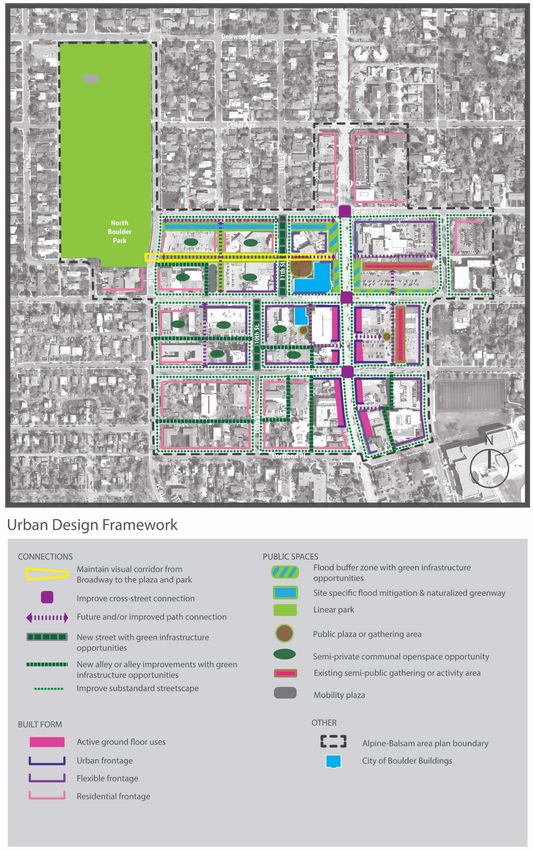
Acknowledgements
Creating this plan has been a collaborative effort, made possible through the dedicated efforts of the
following groups and individuals.

City Council members                                    Chris Meschuk, Interim Planning Director and
Suzanne Jones, Mayor                                    Assistant City Manager
Sam Weaver, Mayor Pro Tem                               Jean Gatza, Project Manager
Aaron Brockett                                          Kalani Pahoa, Urban Design Project Lead
Cindy Carlisle                                          Michelle Allen, Housing and Human Services
Lisa Morzel                                             Amanda Bevis, Public Works
Mirabai Nagle                                           Kathleen Bracke, Transportation/GO Boulder
Bob Yates                                               Yvette Bowden, Economic Vitality, Parks &
Mary Young                                              Recreation
                                                        Michele Crane, Facilities & Asset Management
                                                        Kurt Firnhaber, Housing and Human Services
Planning Board members                                  David Gehr, City Attorney’s Office
Bryan Bowen, Chair                                      Chris Hagelin, Transportation/GO Boulder
Harmon Zuckerman, Vice Chair                            Jeff Haley, Parks and Recreation
David Ensign                                            Sarah Huntley, City Manager’s Office
                                                        Alice Huang, Comprehensive Planning
John Gerstle
                                                        Katie Knapp, Flood/Greenways Utilities
Lupita Montoya
                                                        Chris Ranglos, Comprehensive Planning
Sarah Silver
                                                        Jim Robertson, Comprehensive Planning
Peter Vitale
                                                        Edward Stafford, Public Works
                                                        Andrew Williams, Comprehensive Planning

                                                        Consultants
                                                        Civitas
                                                        Coburn Development
                                                        Fox Tuttle Hernandez
                                                        P2 Solutions
                                                        PUMA
                                                        Starboard Realty
                                                        Wilson & Co.

Staff Members
Thanks also to all the other city staff, board members, and many members of the Boulder Community
who gave their invaluable time and input to help develop this plan.

October 2019                                                                                      Page 2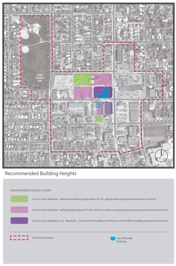
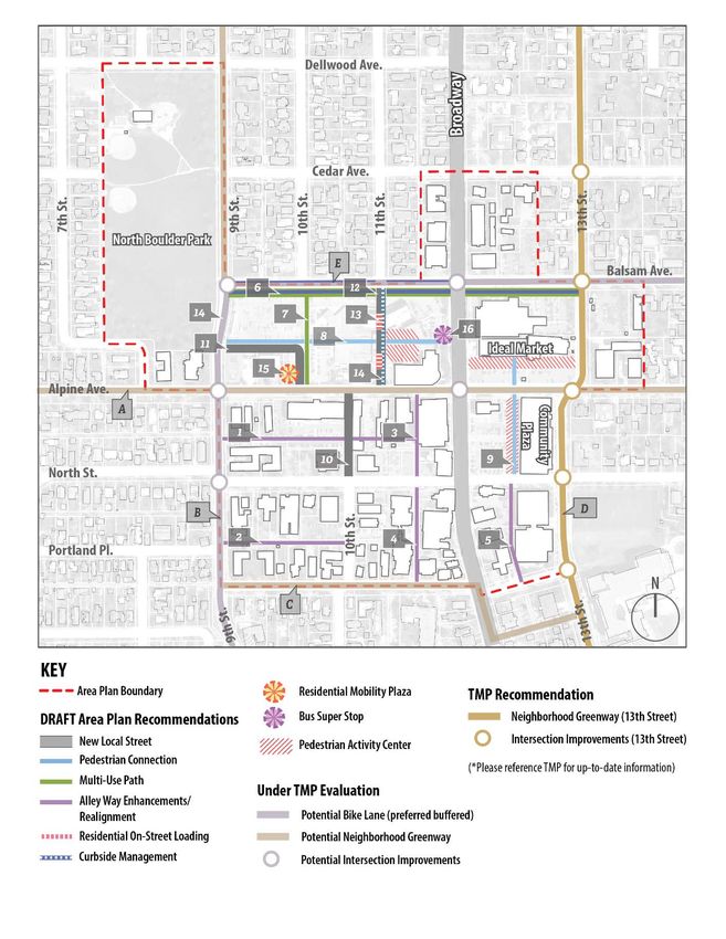
Table of Contents

 Introduction                                               Page 4
 Chapter 1: Vision, Goals and Objectives                    Page 7
 Chapter 2: Key Components of City Site Redevelopment       Page 12
 Chapter 3: Land Use and Urban Design Plan                  Page 16
 Charter 4: Historic Preservation                           Page 45
 Chapter 5: Connections Plan                                Page 47
 Chapter 6: Access and Mobility Strategy                    Page 52
 Chapter 7: Urban Services                                  Page 56
 Chapter 8: Implementation and Next Steps                   Page 61

 Maps and Figures
 Area Plan Boundary                                         Page 4
 Conceptual Diagram of City Site Uses and Improvements      Page 12
 Recommended Land Use Plan                                  Page 18
 Housing Opportunities on the City Site                     Page 19
 Urban Design Framework                                     Page 30
 Recommended Building Heights                               Page 31
 Illustration of the Balsam Greenway and Flood Mitigation   Page 43
 Regional Connections Map                                   Page 50
 Connections Plan                                           Page 51
 Potential Initial Access District Boundary                 Page 54
 City Effective Flood Plains Map                            Page 58

 Appendices
 List of Supplemental Documents                             Page 66
 Connections Plan Improvements Descriptions                 Page 67

October 2019                                                          Page 3
Introduction
Imagine a vibrant neighborhood with a wide range of commercial services and an amenity-rich public
realm. Possibilities come in many forms – beautiful plazas and neighborhood retail that complements
neighborhood needs. A mixed-use main street along Broadway with ground floor uses that are active
and fun to explore. Civic gathering places to serve the community. New housing that offers
opportunities for people to live close to work, shopping and recreation. Greenspaces and new ways to
get around. A place for all generations.

The Alpine-Balsam area includes portions of several lively and well-loved
neighborhoods north of downtown. The Boulder Community Health (BCH)            For the purposes of this
Hospital served the community in this location from 1925 to 2019.              plan, the 8.8-acre former
                                                                               BCH properties will be
The city’s 2015 purchase of the property that formerly housed the BCH          referred to as “the city’s
Hospital was an investment for the community, motivated by the desire to       site” while the rest of the
shape the redevelopment of an area that has been focused around a major        planning area that
healthcare facility for decades, to address the city’s decentralized service   includes privately held
challenges by creating a City Service Center, and to address critical          land, will be referred to
affordable housing needs. The purchase and future redevelopment of the         as “the area”.
BCH property provides an opportune moment to plan for the future of the
Alpine-Balsam neighborhood center and surrounding area.

 Area Plan Boundary

                                                                                                  Page 4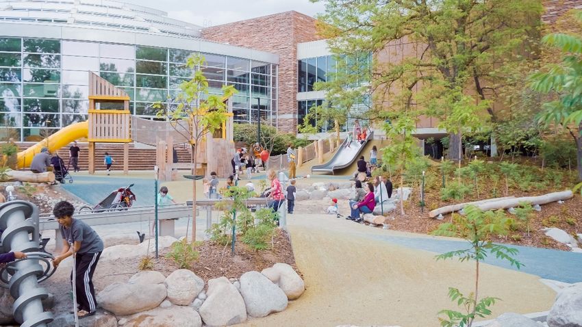
The Alpine-Balsam Area Plan is the result of several years of community processes, a range of analyses
and studies, and thoughtful consideration and direction by Boulder decision-makers.

Purpose of the Plan

This plan describes the future vision for the
approximately 70 acre Alpine-Balsam area and               Why Create an Area Plan?
will guide long-term character and
                                                           Area Plans bridge the gap between the
development of the area. Realization of the
plan’s vision will be achieved by the city, private        broad community goals established in
property owners and potentially other                      the Boulder Valley Comprehensive Plan
development partners (e.g. Boulder County or               and the detailed city review of individual
affordable housing developers). The                        development projects and capital
implementation Plan will be developed after                improvements.
plan adoption as a companion document to this
plan, identifying specific actions the city will           An area plan outlines the desired future
take in the coming years to advance the plan’s             development of an area – its character
goals and objectives.                                      and scale, mix of land uses, and the
                                                           location of streets, paths, parking, public
The area planning for Alpine-Balsam has been a
                                                           spaces and urban services. It also defines
bit different from “conventional” area planning
                                                           desired characteristics that should be
because the city is a landowner for key parcels
within the planning area. This affords greater             preserved, enhanced or prioritized.
opportunities to achieve community goals for
the site. The area plan is intended to bridge the
gap between the broad policies of the Boulder Valley Comprehensive Plan, the goals articulated in the
Alpine-Balsam Vision Plan, and site-specific project development. However, with the city as a
landowner, it also has created the need for vigilance throughout the planning process to ensure that the
final plans are fiscally responsible and achievable, and funding needs for the city-owned sites are
balanced within the context of funding needs for all city priorities.

How the Plan Will Be Used

Members of the public, business and property owners, city officials and staff, and other community
partners will have a guide of what to expect in the future in the Alpine-Balsam area and will guide
decisions about private development, public facilities and services in the area. The plan will guide policy
decisions and regulatory changes that are made subsequent to plan adoption.

The Land Use Plan will be used as the basis for future land use map changes in the Boulder Valley
Comprehensive Plan (BVCP), as well as the basis for rezoning. The Connections Plan is a right-of-way
plan that will be administered according to Boulder Revised Code. The Connections Plan will be used to
guide future right-of-way acquisitions and capital improvement planning, as well as to preserve right-of-
way corridors for future road dedication and construction. The Urban Design Plan will be used describe

October 2019                                                                                         Page 5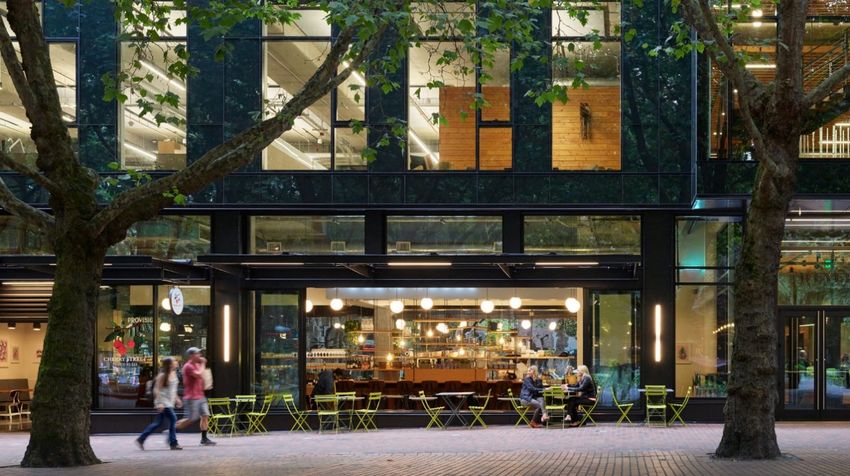
the character of the area in the Site Review Process and help determine whether a project meets Site
Review criteria.

The area plan identifies land use changes for the city-owned land with the Alpine-Balsam planning area.
At the direction of city council, the plan may be amended in the future to consider other land use map
changes within the area plan boundaries.

An Implementation Plan will be developed to guide future actions by the city to implement the plan,
including amending existing regulations and the BVCP land use map; establishing phasing and city
funding for key public improvements; planning capital improvement projects; and coordinating the site
redevelopment project.

Planning Horizon

The Boulder Valley Comprehensive Plan (BVCP) identifies area plans as having a planning horizon of 15
years. While adopted area plans should be periodically revisited as that horizon draws closer, it should
be noted that decisions made in or guided by area plans may have a lasting impact well beyond 15
years. The pace of redevelopment in the broader planning area will be determined by, if, and when
private property owners voluntarily choose to redevelop their properties. Development and
redevelopment guided by the plan might remain in place for generations.

With regard to the city-owned land, deconstruction of the main hospital building, renovation of the
Medical Office Pavilion and redevelopment of the city’s site will proceed as expeditiously as possible in
the near term in order to reduce holding costs and minimize disruption to the neighborhood to the
degree possible.

Plan Amendment Process

Area plans are monitored annually through the Capital Improvements Program (CIP) and the BVCP
Action Plan and updated as needed. Plan amendments will be reviewed and approved by the City
Council and Planning Board. Amendments to the Connections Plan generally will be reviewed either
administratively or by the Planning Board. The process to eliminate any shown connection requires
approval by Planning Board and City Council.

October 2019                                                                                        Page 6
`

Chapter 1: Vision, Goals and Objectives

The Alpine-Balsam Vision Plan, adopted by City Council in 2017 was a first step in the planning process
for Alpine-Balsam. It provided an aspirational foundation for the future vision, that has been assessed
and refined through more detailed analysis in the Area Plan.

                                                        Vision Statement:

                                                        “Alpine-Balsam will be a vibrant multi-
                                                        generational hub for community life and local
                                                        government services – a welcoming and
                                                        inclusive new model for equitable, affordable
                                                        and sustainable living.”

The Alpine-Balsam Area Plan includes the land use, urban design, access and mobility and urban
services elements to realize the vision, goals and objectives stated below. The following describes the
vision for the area and neighborhood.

Vibrant Mixed-Use Neighborhood Center

The Neighborhood Center at Alpine-Balsam will be a vibrant place for community gathering. The current
retail center serves as the heart of nearby neighborhoods, where people gather to obtain basic goods
and services. New public spaces and the new local government service center will increase daytime
activity supporting retail and transit.

Engaging Government – Service Center and Place to Meet

The city owned Alpine-Balsam site is envisioned
as a civic customer service center, a place to
conduct daily business with the city and possibly
county. Less than one mile from other local
government buildings in the downtown and Civic
Area, the new civic service center at Alpine-
Balsam will also offer engaging public spaces
both in and outdoors, inclusive meeting and
gathering spaces, efficient and informative
facilities for people to get information or

October 2019                                                                                       Page 7
`

complete transactions, all in a renovated high-performing building that demonstrates best-practices in
healthy workplaces and sustainable design.

Places to Call Home – New Affordable and Market Housing

The city site presents a unique opportunity for in-fill of both market and affordable housing in the center
of Boulder and within walking distance to downtown. Housing will likely consist of stand-alone
residential buildings such as two- to four-story apartments,
condominiums and townhomes and may include mixed-use
buildings with ground floor services or retail with housing above.
Because the city already owns the land there is a good opportunity
to direct the outcomes of affordable housing that could also
include prioritized affordable housing types such as permanent
supportive housing (housing for vulnerable individuals that include
supportive services) and middle income for-sale housing to help meet city goals for a wide diversity of
affordable housing types and price ranges. If the new Boulder County Health and Human Services Hub
locates at Alpine-Balsam, there will be the potential for new affordable housing at Iris and Broadway.

                                                Maintaining the diverse housing that exists in the area is
                                                a priority of this plan. Through private development,
                                                new housing could serve a range of sizes and
                                                prices/rents to appeal to a variety of lifestyles and
                                                households. Affordable housing would be provided
                                                through the city’s inclusionary housing program which is
                                                likely to result in some on-site affordable for-sale condos
                                                and cash-in-lieu that can be used to create affordable
                                                housing somewhere in Boulder.

 Estimated Range of Potential New Housing Units on the City Site
   City Site without 210-260
     Boulder County

       City Site with 120-170
     Boulder County

October 2019                                                                                        Page 8
`

Easy and Safe Ways to Get Around

Redevelopment at the Alpine-Balsam site presents
opportunities to create a range of travel choices and to
prepare for future transportation trends and technologies.
Strategies for access and mobility at the Alpine-Balsam site
build on proven programs in other parts of the city and can be
expanded to include the wider area over time. Benefits will
include on-going programs to provide convenient and easy-to-
use travel options, managed parking, reduced transportation
costs, and reduced vehicle miles traveled to reduce our carbon footprint and meet the city’s Climate
Commitment and Transportation Master Plan goals.

Environmental, Sustainability, & Climate Commitment

New development at the Alpine-Balsam site will incorporate
sustainable solutions for infrastructure and buildings.
Redevelopment in the area will encourage environmental
improvements including reduction of urban heat island effect
by increasing the tree canopy. A new naturalized greenway
for flood conveyance will add beauty and improve the human
(and pollinator) experience from North Boulder Park to the
neighborhood center.

October 2019                                                                                     Page 9
`

Alpine-Balsam Area Plan Goals and Objectives

LAND USE & URBAN DESIGN

1. Enhance the neighborhood center at Alpine-Balsam to support a vibrant mix of
   uses for community life
       •   Provides a mix of uses necessary for the neighborhood center as a destination
       •   Encourages a mix of uses for day and night activity
       •   Engaging ground floor spaces supporting a variety of active uses

2. Incorporate design and character that respects and enhances the
   neighborhood
       •   Includes a diverse and varied built form to respond to the neighborhood context
       •   Provides permeability to the surrounding neighborhood and North Boulder Park
       •   Concentrates the tallest buildings in the neighborhood center core
       •   Protects historic qualities

PUBLIC REALM & PUBLIC SPACES

3. Provide engaging, welcoming, and inclusive public spaces
       • Provides various scales and types of public spaces
       • Includes high-quality, pedestrian-oriented public realm, including street, walkways
         and indoor and outdoor gathering spaces
       • Develops multi-functional green space for flood control and active and passive
         recreational uses.

LOCAL GOVERNMENT SERVICES

4. Create a centralized local government customer service hub
       •   Provides government services to the community in a safe, efficient and welcoming
           building that is centrally located in the community
       •   Includes space for public art and activities to create a welcoming and inclusive
           community space
       •   Renovations and/or new construction improves energy performance and advances
           climate commitment goals for city facilities

October 2019                                                                           Page 10
`
HOUSING
5. Create diverse and affordable housing
• Allows for a variety of housing sizes and types and prices
• Provides a diverse mixture of housing types that balance market-rate and
permanently affordable units
• Housing serves various community needs and a range of household types
ACCESS & MOBILITY
6. Improve walkability, safety and connections with well-connected and
pedestrian-oriented streets and walkways
• Improves neighborhood connections between the park, retail, services, public spaces,
bus stops and other destinations with improved bicycle and pedestrian pathways
• Develops safe streets and crossings for all modes of travel, especially along Broadway,
for all people all abilities
• Integrates vehicular access to minimize conflicts with pedestrians and bicycles
7. Implement a comprehensive multi-modal access and parking strategy that
supports the full range of mobility choices
• Outlines an Access District to provide a sustainable source of funding for parking
management and Transportation Demand Management (TDM) programs /
• Plans for mobility hub
• Develops sufficient parking for all uses, applying access management and parking tools
and strategies
• Provides on-going TDM programs and services to all employees and residents
• Includes curbside management for ride-sharing and freight pick up and drop off
• Plans for inviting transit / multi-modal experiences with active uses near transit,
sidewalk connections and inviting transit shelters
ENVIRONMENTAL SUSTAINABILITY and FLOOD MITIGATION
8. Integrate environmentally sustainable strategies into the layout and function
of the public realm and built environment
• Includes integrated stormwater and flood management strategies, with a focus on
the benefits of green infrastructure
• Flood mitigation improvements balance naturalized systems with cost-effectiveness
of mitigation and desired land uses.
October 2019 Page 11` Chapter 2: Key Components of City Site Redevelopment Conceptual Diagram of City Site Future Uses and Improvements EAST BLOCK City Service Center in the Renovated Medical Pavilion Alpine-Balsam, and specifically the Pavilion building, present an opportunity for the city to consolidate services into one convenient, accessible and welcoming location on the western side of town where many residents live or work in Boulder. An additional floor may be added to the Pavilion with renovation to increase its capacity for city services and community-serving amenities. The vision for future city buildings is to provide transparent, interactive and informative ground floor spaces that invite the community into buildings to learn, do business with the city, and access services they need. Small retail spaces could further enhance this area and draw in residents on their way to work or on weekends to continue to activate the space after business hours. October 2019 Page 12
`

                                  Specific uses for the northern part of the East Block will remain flexible
                                  at this stage of planning. Depending on the results of the city’s
                                  Facilities Master Plan, this could be the future home for additional
                                  consolidated city services and community uses (e.g. relocated Senior
                                  Center/Multi-cultural center) or could become housing or some
                                  combination of mixed use with housing above.

Connection to Civic Area

The East Block is well positioned to continue to complement the established downtown Civic Area as it is
less than one mile north of the Municipal Building. Enhancements along Broadway between the two
sites would strengthen the civic corridor along Broadway.

Outdoor Civic Space

Arrival at the city buildings at Alpine-Balsam would be experienced first
through outdoor civic space developed to complement the activities
going on inside the Pavilion building during the week and business
hours and provide outdoor amenities the neighborhood could enjoy
during the evenings and weekends.

CENTER BLOCK
Housing to Meet Affordability Goals
The Center Block is designated high density residential to support affordable housing projects that might
include a variety of rental housing, Permanently Supportive Housing (that may serve people
transitioning out of homelessness or people with disabilities) and middle income for-sale housing that
could meet the city goals for a wide diversity of affordable housing types and price ranges.

Apartments along Balsam Avenue will have a significant setback from the street due to the flood
conveyance area and are envisioned to be three stories with the potential to be above 35 feet to
accommodate pitched or different roof forms.

Apartments are envisioned along Alpine Avenue that would be up to four stories. Buildings would
provide a substantial amount (approx. 50%) of meaningful, at-grade open space for residents.

October 2019                                                                                       Page 13
`
Boulder County Service Hub
At the time of area plan adoption, there are several factors that need more analysis to support the
decision-making regarding potentially relocating Boulder County Services at Alpine-Balsam from the Iris
and Broadway Campus. Should the decision be made to move Boulder County facilities, this could be
located in a new four-story building along Alpine Avenue that would serve as a new Health and Human
Services Hub.
The following criteria are included in order to define the desired outcome.
1. Redevelopment of the Iris and Broadway Campus would achieve “materially” more housing and
preferably a higher percentage of affordable housing in the already developed portions of the
campus (i.e. excluding the ballfields).
2. The Boulder County facility can be achieved at Alpine-Balsam in the location along Alpine Avenue
as indicated on the land use map.
3. The county’s parking needs can be met by shared use of the existing city-owned parking structure
(with an additional level of parking added).
4. The civic uses on the site can be designed to achieve high-quality sense of place, appropriate
levels of activity, benefits to the community and neighborhood, high-quality public realm and
community gathering spaces.
5. The city and county will determine appropriate fair compensation for the conveyance of land that
reflects a combination of factors including current market value and city investment. The city and
county will also decide other cost-share agreements related to public infrastructure, operations
and maintenance of the site, and parking to determine the financial feasibility of co-location.
WEST BLOCK
Housing
Housing is envisioned in the West Block in the form of two to three story
townhomes or apartments. Directly adjacent to North Boulder Park and
furthest from Broadway, this area is envisioned as the least dense of the
high-density residential prototypes described in the area plan. Building
heights would be no more than 35 feet.
Note: the parcels at the corner of Alpine and 9th street are privately owned
and not part of the site redevelopment planning. No land use changes are
proposed for these parcels.
SOUTH PARCELS
Two small vacant parcels on the north side of North Street are owned by
the city. The Facilities Master Planning process will evaluate these parcels, and if they are not suitable
for future city needs, they may be sold.
October 2019 Page 14` Access and Parking Land uses on the site will be supported by a range of travel choices. access, mobility and parking choices. The access and mobility strategy for the Alpine-Balsam site includes managed parking, on-going Transportation Demand Management (TDM) programs and services and may include a general improvement district to fund on-going programs and parking management. Parking for the site users, including people accessing city services, city employees and most of the residential uses will be managed using SUMP principles: Shared, Unbundled, Managed, and Paid. Most parking needs for the site will be accommodated in the existing Alpine parking structure with limited new spaces created on the site. If the Boulder County Service Hub is located on the center block, the parking, access and mobility needs for the facility and its customers, employees, clients and visitors will need to be considered as part of the analysis for locating this facility. Flood Mitigation Conveyance The site design will provide for fill and the development of a flood conveyance channel to relocate a portion of and contain 100-year flood flows. These improvements will require updating the regulatory floodplain for this area to remove portions of the city’s site from the current mapped floodplain. The conveyance channel will be located on the northern side of the site along Balsam Avenue. At the time of adoption, the plan illustrates the channel at 100 feet wide as a conservative estimate of the space needed to accomplish the flood conveyance and floodplain development goals. The width of the conveyance channel will be determined as further engineering and site design is completed. October 2019 Page 15
`

Chapter 3: Land Use and Urban Design Plan
The Alpine-Balsam area is one node along the busy Broadway corridor spine that includes the University
Hill area, Downtown Boulder and the Civic Area, the Broadway & Iris Center, and North Boulder. Like
other nodes, it resides on this busy corridor as a pocket of activity with a variety of commercial and
institutional uses surrounded by residential areas. The Alpine-Balsam area developed in the 1950s and
has evolved over time. Moving forward, redevelopment opportunities re-envision this mixed-use
neighborhood with a sustainable urban form.

Land Use                                                             In keeping with the Boulder Valley
                                                                     Comprehensive Plan, the Alpine-
One of the primary ways that an area plan guides future              Balsam area is a “neighborhood
development is by determining land uses. The Boulder Valley          center” that will embody Boulder’s
Comprehensive Plan’s Land Use Map “depicts a plan of the             Sustainable Urban Form in creating a
desired land use pattern in the Boulder Valley. The land use
                                                                     place that is:
designations guide future zoning decisions.” The Alpine-Balsam
                                                                         • Compact, Connected,
Area Plan will guide changes to the BVCP’s Land Use Map and
Land Use descriptions, and the city’s zoning map. These changes
                                                                             Coherent and Complete
-- amending the Land Use Map and re-zonings as appropriate --            • Green, Attractive and Distinct
will be made as part of the implementation of the Area Plan.             • Diverse and Inclusive

                                     Land Use: Existing Conditions

   The Alpine-Balsam area is a lively and well-loved neighborhood center located north of downtown
   Boulder with a thriving commercial center and diverse array of housing.

   Within the planning area there are:

       •   Approximately 400 housing units, owner-occupied and rental, apartments, condominiums,
           single-family homes, townhomes, cooperative housing, and mixed-use buildings.
       •   Existing and potential historic landmarks.
       •   Approximately 2000 jobs (down from a high of 2,700 in the early 2000s).

   With the exception of the city-owned land, projections for future housing or employment growth
   in the area (assuming current zoning) are relatively modest.

   Some redevelopment is possible, but many parcels were developed prior to the current
   regulations and are currently “non-conforming” in that they hold more existing development (i.e.
   more housing units) than would be allowed under current zoning regulations.

   See Alpine-Balsam Existing Conditions Report – Jan. 2019

September 2019                                                                                Page 16
`
Implementation of the Alpine-Balsam Land Use Plan will change the BVCP Land Use Designations for the
city-owned properties and inform new zoning. Even though land use changes are not included in the
first phase of the area plan for properties other than city-owned, the Urban Design and Connections
Plan will apply to all properties in the planning area. None of those changes will require landowners to
make any changes to their properties. Rather, the underlying purpose of the plan is to identify the
future desired character of the area, and thus implement key goals of the BVCP including: increasing
housing affordability and diversity; addressing the jobs-housing imbalance by increasing housing in
commercial areas; ensuring design quality and placemaking; and supporting and retaining small local
businesses.
Approach
The Land Use Plan reflects an approach that thinks of the Alpine-Balsam Neighborhood Center as a
collection of roughly-concentric character districts – core, gateways and transitions, and edges. The
intensity of uses, the heights, and the density all generally diminish from core to edge.
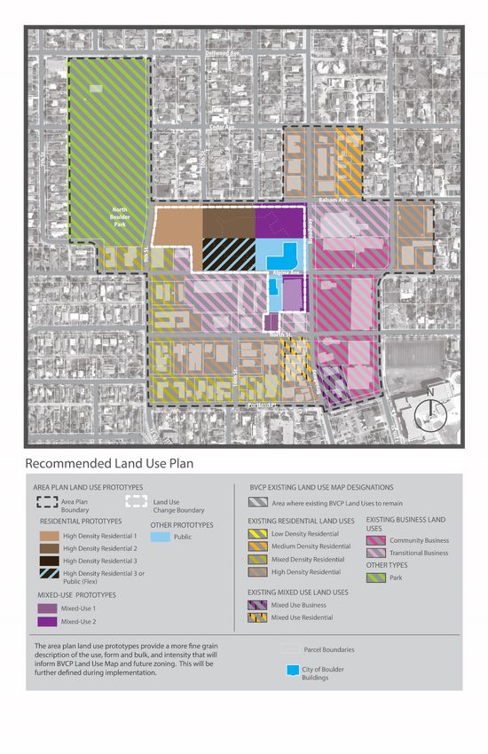
The Land Use Plan consists of three components:
• A map showing new Land Uses for the city-owned properties in the planning area.
• A narrative section describing how the plan addresses the major categories of land uses (i.e.,
residential, business, mixed-use).
• Land Use Prototypes: The prototypes show the building forms and uses typically associated with
each land use category identified in the Land Use Plan.
September 2019 Page 17` September 2019 Page 18
`

September 2019   Page 19
`

Civic Uses

Two parcels of the city-owned land are designated Public:

    •   The parcel on which the new City Service Center will be located in the renovated Medical Office
        Pavilion Building.
    •   The parcel on which the city-owned Brenton Building is located.

A third parcel, to the west of the Pavilion, is designated either Public or High Density Residential -3. This
either-or designation will allow that parcel to accommodate either a building for the delivery of Boulder
County services or high-density housing (likely in the form of an apartment building up to four stories).

The city-owned parking structure at the southwest corner of the Broadway-Alpine intersection (with a
ground floor banking use and restaurant use) is designated Mixed Use -2. This land use classification
accommodates the commercial ground floor uses and allows the addition of an additional level of
parking.

Housing Opportunities on the City Site

The Land Use Plan encourages maintaining existing housing and provides the opportunity for a variety of
new housing, including housing types and price ranges to meet diverse needs and incomes: from urban
townhomes to apartments to units included in mixed-use buildings. Prices will range from affordable to
market rate.

                                                                               1b       1a
                                                             1d

                                                                               1c

                                      Housing Opportunities on the City Site

    •   For the city-owned parcels bounded by Alpine, Balsam, Broadway and 9th:

September 2019                                                                                       Page 20
`
a. Northeast parcel (at the southwest corner of Broadway and Balsam): The land use
designation is Mixed Use – 2. This parcel will accommodate a “flex” building. The
building, up to four stories tall, will be required to have some ground floor pedestrian-
oriented uses (oriented towards Broadway and the plaza separating it from the Medical
Pavilion to the south), but the upper stories could be residential or non-residential (e.g.,
office) uses.
b. North-central parcel: The land use designation is High Density Residential – 2. Buildings
here would likely take the form of apartments (a conventional apartment
configuration), could be up to three stories tall, and could accommodate a density of
approximately 30-60 dwelling units per acre.
c. South-central parcel: As noted above (“Civic Uses”), this parcel is designated either Civic
or High Density Residential - 3. This either-or designation will allow that parcel to
accommodate either a building for the delivery of Boulder County services
(approximately 120,000 square feet of floor space) or high-density housing (likely in the
form of an apartment building up to four stories with apartments).
d. Northwest parcel: The land use designation is High Density Residential – 1. Buildings
subject to this designation would likely take the form of alley-loaded townhome units or
low-rise, small scale apartments, could be up to two or three stories tall, and could
accommodate a density of up to about 30 dwelling units per acre. Some or all of the
units built on this parcel likely will be market-rate housing.
Residential and Business Land Uses in the Area
For the parcels not owned by the city, no changes to land uses are proposed at this time, however a few
general principles apply:
• The general intensity of uses, heights, and density diminishes as the distance from the core
increases
• Housing is important to be maintained or encouraged if uses change.
Business Uses
Community Business: The retail centers are highly valued and should remain as anchors of the
neighborhood center. The Community Business land use designation indicates this area as the focal
point for commercial activity serving the daily convenience shopping and personal service needs of
nearby residents and workers and support the goal of walkable communities. Where feasible, multiple
uses, including housing, will be encouraged.
Transitional Business: Properties with the Transitional Business land use designation indicates less-
intensive business uses than Community Business, providing a transition to residential areas and can
include a mix of uses, including housing on a limited basis.
Mixed Use: Several properties along Broadway are designated for Mixed Use Business or Mixed Use
Residential. A mix of neighborhood-scale retail and personal service uses with housing is encouraged.
September 2019 Page 21` Residential Uses Housing in the Mixed Density and High Density residential areas has evolved over time, much constructed before the current zoning was in place. The result is many nonconforming uses, nonstandard buildings, and nonstandard lots, that contribute to the area’s diverse mix of housing that is unique and charming. The city’s regulations allow legal nonconforming uses and nonstandard buildings to be changed, upgraded, and expanded without requiring their elimination, if the change would not substantially adversely affect the surrounding area and if the change would not increase the degree of nonconformity of the use. Land Use Prototypes The prototypes on the next pages show the building forms and uses typically associated with each land use category of the Land Use Plan. They also describe who will likely live and work in each. September 2019 Page 22
`

High Density Residential 1 (HDR1)
This land use prototype is the least dense of the high-
density residential prototypes. It is characterized by 2-3
story, alley-loaded townhome units and/or low-rise,
smaller footprint apartment buildings.

Generally, this prototype would have at-grade common
open space or greenspace, e.g. garden court. Any
private open space could be located on balconies, roof
decks or small yards.

Townhomes would likely self-park (not utilize shared
parking in structure). Apartments could either self-park
with tuck-under parking or if the property is part of the
parking district, parking would be satisfied in an off-site
location. This land use type is envisioned as part of
comprehensive transportation demand management
system including adjacent location to enhanced multi-
modal facilities and services, convenient on-street
loading and reduced the parking supply.

Use, Built Form, & Intensity

Housing types include townhomes or apartments
between 2-3 Stories. Building heights would be no more
than 35'. This area is envisioned with a substantial
amount of meaningful and usable open space at grade.
The open space could be a mix of private and communal
spaces. Minimum open space square footage per unit or
in aggregate would be defined during the
implementation phase. Of this open space, a
meaningful, communal use area is required.

Who would live here?

Housing units like this attract couples, singles, or
families. Pricing can range from affordable to high-end,
market rate.

Townhome units with visible yard space could be
particularly attractive to families with children.
Apartments could provide affordable housing to serve
diverse populations, including seniors, people living
with disabilities, or those needing permanently
supportive housing.

September 2019                                                    Page 23
`

High Density Residential 2 (HDR2)
This land use prototype is characterized by 3 story, low-
rise apartment buildings. It would include meaningful,
at-grade common open space. Any private open space
would be located on balconies or patio spaces.

Buildings in this area may have more generous setbacks
from the street or emphasized entry courts.

If the property is part of the parking district, all parking
would be satisfied in an off-site location. This land use
type is envisioned as part of comprehensive
transportation demand management system including
adjacency to enhanced multi-modal facilities and
services, convenient on-street loading, and reduced
parking supply.

Use, Built Form, & Intensity

This land use is designed for housing up to 3 Stories.
Building heights would be within 35’ with any exception
over the 35’ to allow for appropriately proportioned
pitched roof forms. This area is envisioned with a
substantial amount of meaningful and usable open
space at grade. Preliminary study indicates at least
approximately 50% of the lot reserved for open space
uses. Minimum open space square footage per unit or
in aggregate would be defined during the
implementation phase. Of this open space, a
meaningful, communal use area is required.

Who would live here?

Housing units like this attract couples, singles, or small
families. Units with more bedrooms and appropriately
programmed for children could be attractive to families.
Pricing can range from affordable to high-end, market
rate. Apartments could provide affordable housing to
serve diverse populations, including seniors, people
living with disabilities, or those needing permanently
supportive housing.

September 2019                                                     Page 24
`

High Density Residential 3 (HDR3)
This land use prototype is characterized by 4 story, mid-
rise apartment buildings. It would include meaningful,
at-grade common open space. Any private open space
would be located on balconies or patio spaces.

If the property is part of the parking district, all parking
would be satisfied in an off-site location. This land use
type is envisioned as part of comprehensive
transportation demand management system including
adjacent location to enhanced multi-modal facilities and
services, convenient on-street loading and reduced
parking supply.

Use, Built Form, & Intensity

This land use is designed for housing up to 4 Stories.
Building heights would be between 35’ and 55’ to allow
for a fourth floor and any appropriately proportioned
pitched roof forms. This area is envisioned with a
substantial amount of meaningful and usable open
space at grade. Preliminary study indicates at least
approximately 50% of the lot reserved for open space
uses. Minimum open space square footage per unit or
in aggregate would be defined during the
implementation phase. Of this open space, a
meaningful, communal use area is required.

Who would live here?

Housing units like this attract couples, singles, or small
families. Units with more bedrooms and appropriately
programmed for children could be attractive to families.
Pricing can range from affordable to high-end, market
rate. Apartments could provide affordable housing to
serve diverse populations, including seniors, people
living with disabilities, or those needing permanently
supportive housing.

September 2019                                                     Page 25
`

Mixed Use 1 (MU1)
This land use prototype is characterized by low-rise
buildings up to 3 stories. It was developed to include
flexibility for either mixed or single use of commercial
and residential occupancies.

Strictly mixed-use with active, ground floor uses, like
retail and other personal services, with residential or
office uses above is reserved for areas along Broadway
in the neighborhood’s commercial core. Flexibility for
either mixed-use or single uses, including standalone
residential and commercial uses, is reserved for areas
outside or on the fringe of the neighborhood’s
commercial core.

If the property is part of the parking district, all parking
would be satisfied in an off-site location. This land use
type is envisioned as part of comprehensive
transportation demand management system including
adjacent location to enhanced multi-modal facilities and
services, convenient on-street loading and reduced
parking supply.

Use, Built Form, & Intensity

This land use prototype is characterized by low-rise
buildings up to 3 stories. Building heights would
generally be within 35’ with an exception over 35’ to
allow for a taller first floor for mixed-use buildings and
any appropriately proportioned pitched roof forms. The
density would allow up to 1.5 floor-area-ratio.

Who would live and/or work here?

Housing units like this attract couples, singles, and
seniors. Pricing can range from affordable, with
workforce housing, to high-end, market rate.

Commercial uses can range from retail (e.g. stores and
restaurants) and personal services (e.g. yoga studios,
day care) for active ground floor uses to professional
services (e.g. medical and law offices) on the upper
floors or in single use buildings.

September 2019                                                     Page 26
`

Mixed Use 2 (MU2)
This land use prototype is characterized by mid-rise
buildings up to 4 stories. It was developed to include
flexibility for either mixed or single use of commercial
and residential occupancies.

Strictly mixed-use with active, ground floor uses, like retail
and other personal services, with residential or office uses
above is reserved for areas along Broadway in the
neighborhood’s commercial core. Flexibility for either
mixed-use or single uses, including standalone residential
and commercial uses, is reserved for areas outside or on the
fringe of the neighborhood’s commercial core.

If the property is part of the parking district, all parking
would be satisfied in an off-site location. This land use
type is envisioned as part of comprehensive
transportation demand management system including
adjacent location to enhanced multi-modal facilities and
services, convenient on-street loading and reduced
parking supply.

Use, Built Form, & Intensity

This land use prototype is characterized by low-rise to
mid-rise buildings from 3-4 stories. Building heights
would generally between 35’ and 55’ with an exception
over 35’ to allow for a taller first floor for mixed-use
buildings, a 4th floor and/or to allow for a 5th floor of
parking to be added to the existing city parking garage.
The density would allow up to 2.5 floor-area-ratio, with
a singular exception for the existing parking structure to
exceed the 2.5 FAR.

Who would live and/or work here?

Housing units like this attract couples, singles, and
seniors. Pricing can range from affordable, with
workforce housing, to high-end, market rate.
Commercial uses can range from retail (e.g. stores and
restaurants) and personal services (e.g. yoga studios,
day care) for active ground floor uses to professional
services (e.g. medical and law offices) on the upper
floors or in single use buildings.

September 2019                                                       Page 27
`

Public (PUB)
This land use prototype is characterized by mid-rise buildings up
to 5 stories. It was developed to include flexibility for the
renovation of the medical office pavilion for a city service center
and the possible co-location of county facilities.

The public land use prototype is situated adjacent to areas
marked for public gathering. Buildings in this area will be
designed to complement and integrate with the public realm.

If the property is part of the parking district, all parking would
be satisfied in an off-site location. This land use type is
envisioned as part of comprehensive transportation demand
management system including adjacent location to enhanced
multi-modal facilities and services, convenient on-street loading
and reduced parking supply.

Use, Built Form, & Intensity

This land use prototype is characterized by buildings up to 5
stories and 55’. There are no density limitations for this
prototype, but it is desirable to have a minimum 20% of the lot
programmed as at grade, usable open space for public
gathering.

Who would work here?

Public uses in this area include city and county services. County
services include relocating Health and Human Services from the
Iris & Broadway location. City services in this area will be
determined by the City of Boulder Facilities Master Plan.

September 2019                                                            Page 28
`

Urban Design Plan

As a neighborhood center, the area is focused around the intersection of Alpine Avenue and Broadway.
The overall city block organization is the convergence of small to large block types and in various
configuration. The core of the neighborhood center is marked by a large, decommissioned hospital site,
iconic mid-century modern commercial buildings with informal community gathering areas and low to
mid-rise infill commercial development. Around the core is a mix of medium and larger footprint
commercial, institutional and residential apartment buildings, spanning several eras to include both
historic and contemporary styles. Ringing the edge of the area plan boundary is an expansive park with
views of the mountains and mixed-density housing types that transition to single-family housing.

Urban Design Purpose

The purpose of the Urban Design Plan is to guide
                                                        What is the public realm?
the maintenance and improvement of the built
                                                        The public areas within the city including
environment and the public realm. It identifies
                                                        the streets, sidewalks, plazas, open spaces
aspects and features of the spaces between the
                                                        and parks.
buildings and provides initial guidance for the
design character of future buildings. The urban
                                                        What is the built environment? All the
design objectives describe the elements necessary
                                                        human-made buildings, facilities and
to achieve a high-quality built environment and
                                                        environment that people occupy.
public realm. The plan will guide any future design
controls (design guidelines, form-based code, or
other) that may be identified as part of the
implementation of the area plan.

This section includes urban design strategies for the following areas:

    •   Built Form
    •   Public Realm and Open Space
    •   Connectivity
    •   Sustainability

September 2019                                                                                 Page 29
` Urban Design Framework Map September 2019 Page 30
`

Building Height Map

September 2019        Page 31
`

Urban Design Strategies for the Built Form

   •   Locate the tallest buildings along Broadway and near the neighborhood center core along Alpine
       Avenue.
   •   Encourage compact infill development.
   •   Create permeability between buildings.

   Example of a Pathway Creating Permeability Between Buildings

   •   Preserve and adaptively reuse historic properties.
   •   Utilize the landscape features of the Balsam greenway to establish a natural buffer and soften
       the transition in scale to the single-family residential on the north side of the street.

September 2019                                                                                 Page 32
`
• Building design, especially with respect to massing and placement, should seek to positively
frame the street.
• Along Broadway develop a pedestrian friendly, urban frontage with buildings located close to
generous pedestrian walkways, landscape zones able to sustain large, mature trees, amenity
zones for street furniture, wayfinding and public art, and building frontages zones that
encourage uses to spill out and engage the street.
Example of a Pedestrian-Friendly Urban Frontage with Mature Trees, Ample Sidewalks and Street Activation
September 2019 Page 33`
• Outdoor public gathering and open spaces should be integrated into site plans in a manner that
creates a place for residents, employees or visitors to the building to enjoy the outdoors.
• Mass buildings to complement and frame public open spaces.
Example of a Public Building Framing the Adjacent Public Open Space
• Design buildings with a coherent design expression with cohesive style, material and form.
• Design buildings to express architectural legibility and hierarchy of building form and pattern
where the casual observer can differentiate between the public versus private realms and the
overall use and organization of the building.
• Design buildings with a defined base, middle and top.
• Design pitched roofs proportional to the mass and scale of the body of the building.
• Avoid large expanses of blank facades on building elevations.
• Design primary entry features to be visible and easily identifiable from walkways, open space
and/or the street.
• Increase the human-scale design elements and frame the pedestrian experience by developing
the horizontal and vertical rhythm and pattern in the building form.
• Use durable, high-quality building materials.
• Minimize the visual and physical impacts of auto-oriented uses and vehicle areas.
• Minimize the visual impact of the back-of-house, utility and mechanical uses.
• Design community-serving civic or public buildings as landmarking and wayfinding opportunities.
September 2019 Page 34`
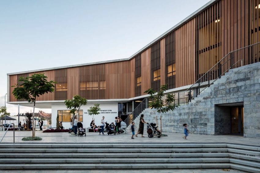
Example of a Public Building Utilizing a Pronounced Entry as a Wayfinding Feature
• When designing higher density, multi-family housing:
o Place larger, family units near or within sightlines of common areas and open spaces
programmed for children to play.
o Locate appropriate common areas of a building at the ground to engage the street or
public spaces.
o Provide storage within units or near easily accessible areas within the building.
o Include common amenity areas, like loading zones, community rooms, dog washing
stations, bike repair or small workshop rooms, gardening and play areas, etc.
o Consider providing individual private open space in the form of patios or balconies.
o Consider providing additional front yard setbacks matching the prevailing setback of
other similar housing types on the block.
o Consider a residential frontage with a larger front yard setback.
September 2019 Page 35`
Example of a Multi-Family Residential Building with a Residential Setback Including a Generous Front Yard with Porch Area and
Landscaping
• When designing mixed-use buildings:
o Create an active and engaging building frontage zone.
o Proportion the first floor with a taller floor to ceiling height than the upper floors.
Example of a Mixed-Use Building with a Taller First Floor Ceiling Height
September 2019 Page 36`
Urban Design Strategies for the Public Realm and Open Space
• Establish a more formalized neighborhood center with additional open spaces for people to
gather, including:
o Construct a large public plaza between 11th Street and Broadway as the primary public,
open space node near the commercial center of the neighborhood.
Example of a Public Plaza Space with User Amenities
o Consider smaller courtyards, patios or yard areas to the area south of the Brenton
Building on Alpine Avenue and on the Community Plaza block.
Example of a Small Courtyard Space with Public Art
o Establish a primary linear
greenway bisecting the
redeveloping hospital site and
connecting the plaza along
Broadway to North Boulder Park.
o Establish a secondary linear
greenway as part of the
connection and circulation to the
mobility plaza and as an extension
of 10th Street on the redeveloping Figure 1 Example of a Linear Park with Connections and Active
Uses
hospital site.
September 2019 Page 37`
o Maintain the existing semi-public gathering places along the Community Plaza and Ideal
Market building frontage.
• Utilize the public realm to provide access to civic and public amenities.
• Design public spaces that are visually and physically accessible from the sidewalk.
• Design and program larger public spaces to be multi-functional.
• Create open spaces welcoming to all ages and abilities in a variety of scales and types.
Examples of Open Spaces Designed for All Ages
• When designing civic buildings integrate and harmonize adjacent outdoor public gathering
spaces for a complementary relationship.
Example of a Public Building Programmed with a Complementary Open Space
September 2019 Page 38`
• Utilize landscaping, lighting, surface materials, seating and other amenities to create inviting and
pleasant areas.
• Incorporate opportunities for public art.
• Encourge additional semi-private open space areas at the ground to be programmed to
complement the associated use.
September 2019 Page 39`
Urban Design Strategies for Connections
• Create better visibility for cross street connection along Broadway at Balsam, Alpine and North
Streets through intersection surface treatments improvements;
• Maintain a visual connection from the public plaza on the hospital site to North Boulder Park.
• Reconnect the existing street network and create smaller city blocks through the superblocks
west of Broadway.
o Add a new 11th Street connection from Alpine Avenue to Balsam Avenue
o Complete the 10th Street connection from North Street to Alpine Avenue.
Exhibit of the Incomplete 10th Street Connection
• Reconnect and improve existing alleys.
Example of a Reconstructed Green Alley
September 2019 Page 40`
• Increase pedestrian friendly paths to allow people to traverse the area at mid-block.
Example of a Mid-Block Connection with Activation
• Improve the pedestrian quality of the streetscape and redevelop substandard back of curb
elements to include adequate sidewalks, street trees and landscaping, and street furniture.
Example of a Streetscape with Adequate Sidewalks, Street Trees and Street Furniture
September 2019 Page 41`
Urban Design Strategies for Sustainability
• Consider or incorporate green infrastructure solutions into new or redeveloped connections,
infrastructure, public spaces and site development.
What is Green Infrastructure?
Green infrastructure is a cost-
effective, resilient approach to
managing wet weather impacts that
provides many community benefits.
While single-purpose gray
stormwater infrastructure—
conventional piped drainage and
water treatment systems—is
designed to move urban stormwater
away from the built environment,
green infrastructure reduces and
treats stormwater at its source while
delivering environmental, social, and
economic benefits.
Example of Green Infrastructure Infiltration Planter
Green infrastructure solutions can be
• Shape the flood conveyance mitigation for the properties applied on different scales, from the
along the south side of Balsam Avenue into a naturalized house or building level to the
greenway and encourage the preservation of existing broader landscape level. On the local
healthy trees. level, green infrastructure practices
include rain gardens, permeable
• Integrate the buffer area for the release of flood waters pavements, green roofs, infiltration
onto Broadway between Balsam and Alpine Avenues into planters, and trees and tree boxes.
the plaza space design and treat this area as an At the largest scale, the preservation
opportunity to shape or sculpt the plaza transition that and restoration of natural
brings a green corridor from North Boulder Park to the landscapes (such as forests,
floodplains and wetlands) are critical
center of the neighborhood.
components of green infrastructure.
(Source: EPA & AmericanRivers)
September 2019 Page 42`
Illustration of the Balsam Greenway and Flood Mitigation
• Encourage the reduction of the urban heat island effect in the area, for example utilize cool or
green roofs, increase the tree canopy for shade and add naturalized open spaces, etc.
• Encourage passive building
design solutions, for example sun
shading devices, thermal mass
strategies, maximizing natural
lighting to the interior of the
building, building orientation for
natural cross-ventilation and
high-performance building
envelopes, and reduce the energy
demand on the mechanical and
electrical systems to complement
other active measures for
renewable energy.
• Encourage healthy buildings Example of Passive Solar Shading Devices on a Building
that are environmentally
September 2019 Page 43`
responsible and resource efficient, e.g. utilize recycled materials, improve the indoor air quality
with materials that have low levels of volatile organic compound emissions, etc.
Example of a Plaza with User Amenities and Green Infrastructure including Infiltration Planters
September 2019 Page 44`
Chapter 4: Historic Preservation
History of the Alpine-Balsam Area
Prior to 1950, the Alpine-Balsam area was sparsely populated and consisted of primarily single-family
houses, with the properties along Broadway between Portland and Balsam functioning as a retail center
since the early 1900s, when the first restaurants, gas stations
and shops were established to serve customers in the
surrounding neighborhoods.
The Boulder Community Hospital groundbreaking was held in
1925, converting the Ben Hagman house into its facilities and
expanding the following year. The designated Mapleton Hill
Historic District is located southwest of the site and was
primarily developed between 1865 and 1946. Casey Middle
School, constructed in 1924, has served as a community anchor
to the east, while North Boulder Park, first suggested in Saco
DeBoer’s 1922 Plan of Improvements for Boulder, has offered a
recreational amenity to the west.
In the 1950s, the city limits extended north, and Broadway was
widened and repaved. The area solidified as a retail and
employment center with the establishment of the Ideal
Marketplace, the Community Plaza, and the Esquire offices
between 1950 and 1955. The surrounding area also grew as the
Sunset Hills and Edgewood neighborhoods to the east
developed in response to Boulder’s growth in the post-war era
and continue to provide single-family housing. Multi-family
residential buildings were also built in the 1960s-1970s, many
exemplifying mid-century modern design elements indicative of
that time period.
Historic Preservation Considerations
The Alpine-Balsam Area has a neighborhood character with eclectic mix of building types, styles and
vintages. The Area Plan seeks to balance increased density and the important community value of
maintaining neighborhood character and preserving buildings and sites that are significant to Boulder’s
history. Initial observations from Historic Preservation staff include:
September 2019 Page 45You can also read