Alaska's 2022 Fire Potential Outlook
←
→
Page content transcription
If your browser does not render page correctly, please read the page content below
Alaska’s 2022 Fire Potential Outlook                                                                         Updated: 6/15/2022

                                               Despite above normal snowpack and a late melt,
                                               warm, dry weather in late May and early June
                                               have pushed our mid and upper fuels into an
                                               exceptionally dry range for early fire season. In
                                               particular, many fires are burning in Southwest
                                               due to early season lightning. This sets the heart
                                               of fire season to be quite busy. Click for details.

           Snowmelt – Mid June                                                                                                             Mid June – Mid July
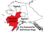
                                                                                                                          With duff already quite dry and no relief
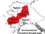
                                                                                                                          forecast, it is expected that elevated activity
End-of-season rains are expected to arrive                                                                                will continue in Southwest and expand into
on time, so mid to late August fires will                                                                                 the central Interior. Resistance to control is
no longer be supported by the middle fuel                                                                                 rising, and lightning, low humidity, and
layers. Existing fires will show some                                                                                     wind events will continue to create above
activity during the day, but resistance will                                                                              normal conditions. Click for details.
be minimal. Click for details.

                                                                          With above normal temperatures forecast
                                                                          for mid-summer and many areas already
                                                                          extremely dry, expect elevated potential for
                                                                          July and early August. If fires from the duff
                                                                          stage remain uncontrolled, they’ll have very
                                                                          high resistance to extinguishment, raising
          Early August – Snowfall                                         acreage during this time. Click for details.                    Mid July – Early August
Wind-Driven Season Back to main slide
Snowmelt - Mid June
• Weather: A large snowpack and cool spring led to a late start to fire season. The last ten days of May and
beginning of June saw a drastic warming and drying trend overtake the Interior and Southwest Alaska,
leading to near historic dryness of the upper and mid layers of duff. A series of large lightning events in
Southwest led to numerous fire starts and rapid growth in the dried fuels.
• Fuels: The U.S. Drought Monitor shows an area of Abnormally Dry for much of Southwest and the central
Interior as well as Moderate Drought for the Mat-Su Valleys and the northern Kenai Peninsula. The Canadian
Forest Fire Danger Rating System’s Buildup Index shows that mid and upper layers of fuels are at historic
values in Southwest and South Central, while the values in the central and eastern Interior are rapidly
approaching maximum observed values. In addition, fine surface fuels have been burnable nearly statewide
for the first half of June.
• Fire Activity: On June 1st, there were 150 fires for 13,335 acres. As of June 15th, there are 253 fires for a
total of 835,368 acres, which is well above the typical season total acreage of about 500,000 acres. With dry
weather and fuels ripe for ignition, a number of lightning events in Southwest led to these many ignitions
and large fire growth. This ease of ignition and rapid growth was indicated by the Canadian Forest Fire
Danger Rating System indices found on the Alaska Fire & Fuels website.Duff-Driven Season Back to main slide
Mid June - Mid July
• Outlook Summary: At this time, there are a lot of fires in Southwest. Though some are burning in
Limited Fire Management areas, many are burning in higher priority areas and/or areas that need point
protection of structures and resources. With the focus of hottest and driest weather forecast to move to
the northeast corner of the state, the next month is expected be very busy, particularly in the central and
southwestern Interior.
• Weather and Climate: Warm and dry weather is forecast for the central and eastern Interior for the
next few weeks, with the chance for afternoon showers and thunderstorms on most days. Southwest will
see some moderation, but several days of rain accumulating to about an inch is needed to truly stop fires
there, and that is not in the forecast at this time. In addition, South Central is also quite dry and could
quickly see problem fires emerge with either human or natural ignition sources.
• Fuel Conditions: Predictive Services Alaska has issued a Fuels and Fire Behavior Advisory for the
Southwest and the central Interior. With the solstice, daylight hours are long and sun angle is high, so
solar heating can cause drastic warming and drying of fuels. Fuels are already extremely dry, and the
indices representative of deeper fuel layers are near record in parts of the state. This indicates that even
the mid and deeper layers are burnable, meaning that fires will burn hotter and more completely, and
will endure even moderate rain events. They are also becoming resistant to control efforts.Cumulative Drought Season Back to main slide
Mid July – Mid August
• Outlook Summary: With extremely dry mid and deeper duff fuels in mid-June, and the bulk of the
lightning season still ahead, there will be a lot of fire to manage in extremely dry fuels by the time we
move into the full-blown Cumulative Drought stage. Expect Southwest and the central Interior to
present above normal fire activity. The northeast Interior will also have the potential to see busier than
normal activity during this time, and that area is typically one of the busiest during this stage.
• Weather and Climate: In a classic Alaskan summer, this period is the crux of the warmest and driest
weather. Though some more stratiform rainfall events may occur in parts of the state, drying continues
to be the predominant factor. Heating of forest and grass fuels is still strong, though daylight hours and
sun angle are decreasing.
• Fuel Conditions: With the drought-related indices approaching near-record values in June, it’s likely
that mid-summer stage will see explosive fire growth and significant resistance to extinguishment.
Extensive resources will continue to be needed in order to provide any measure of control, much less
full suppression.Diurnal-Driven Season Back to main slide
Mid August - September
• Outlook Summary: By this stage, it is expected that the typical end-of-season rains will have
impacted the mid and deeper duff, and fires will be more easily managed. Therefore, this part of the
season is expected to see normal fire activity.
• Weather and Climate: The effective end to fire season comes when end-of-season rains arrive.
Though this can happen as early as the end of July, it usually occurs closer to mid-August. At the same
time, the amount of solar heating falls off drastically, reducing the potential for surface fuels to dry out
after a significant rainfall.
• Fuel Conditions: Though the deepest layers will likely remain dry, rain events bring enough
precipitation to wet down the upper and mid fuel layers. This makes ignition a challenge, so new fires
are limited. Resistance to control is no longer an issue, and fires are easily caught and extinguished.
Freezing temperatures and snowfall in September draw the final line for fire season’s end. Back to main slide
Wind-Driven
st
May 1 Snowpack Map Verification th
May 15 Adjective Rating
Smoke Plumes June 10th June 10th Adjective RatingYou can also read


