Achany Extension Wind Farm - SSE Renewables Developments UK Ltd Desk Study and Phase 1 Habitat Survey Report
←
→
Page content transcription
If your browser does not render page correctly, please read the page content below
SSE Renewables Developments UK Ltd

      Achany Extension Wind Farm
    Desk Study and Phase 1 Habitat Survey Report

Wood Environment & Infrastructure Solutions UK Limited – June 2021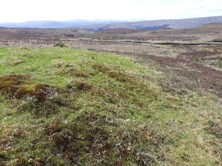
2            © Wood Environment & Infrastructure Solutions UK Limited

Report for                                                                          Copyright and non-disclosure notice
                                                                                    The contents and layout of this report are subject to copyright
Karen Anderson                                                                      owned by Wood (© Wood Environment & Infrastructure
Consent Manager, SSE Renewables                                                     Solutions UK Limited 2020) save to the extent that copyright
                                                                                    has been legally assigned by us to another party or is used by
                                                                                    Wood under licence. To the extent that we own the copyright
                                                                                    in this report, it may not be copied or used without our prior
                                                                                    written agreement for any purpose other than the purpose
Main contributors                                                                   indicated in this report. The methodology (if any) contained in
Hannah Rowding                                                                      this report is provided to you in confidence and must not be
                                                                                    disclosed or copied to third parties without the prior written
                                                                                    agreement of Wood. Disclosure of that information may
                                                                                    constitute an actionable breach of confidence or may
Issued by                                                                           otherwise prejudice our commercial interests. Any third party
                                                                                    who obtains access to this report by any means will, in any
Hannah Rowding                                                                      event, be subject to the Third Party Disclaimer set out below.
.................................................................................

                                                                                    Third party disclaimer
                                                                                    Any disclosure of this report to a third party is subject to this
Approved by                                                                         disclaimer. The report was prepared by Wood at the instruction
                                                                                    of, and for use by, our client named on the front of the report.
Alastair Miller                                                                     It does not in any way constitute advice to any third party who
.................................................................................   is able to access it by any means. Wood excludes to the fullest
                                                                                    extent lawfully permitted all liability whatsoever for any loss or
                                                                                    damage howsoever arising from reliance on the contents of
                                                                                    this report. We do not however exclude our liability (if any) for
                                                                                    personal injury or death resulting from our negligence, for
Wood                                                                                fraud or any other matter in relation to which we cannot legally
                                                                                    exclude liability.
Doc Ref. 805906-WOOD-XX-XX-RP-OE-0001_S3_PO1.3

                                                                                    Management systems
                                                                                    This document has been produced by Wood Environment &
                                                                                    Infrastructure Solutions UK Limited in full compliance with the
                                                                                    management systems, which have been certified to ISO 9001,
                                                                                    ISO 14001 and OHSAS 18001 by LRQA.

                                                                                    Document revisions

                                                                                     No.       Details                             Date

                                                                                     1         Draft                               February 2020

                                                                                     2         Draft - amended                     April 2021

                                                                                     3         Draft - amended                     May 2021

June 2021
Technical Appendix 8.1: Desk Study and Phase 1 Habitat Survey Report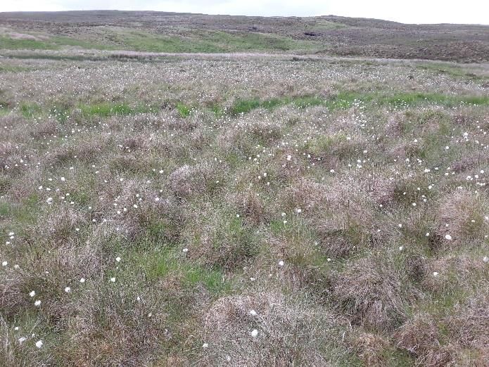
3      © Wood Group UK Limited

Contents

1.           Introduction                                                                                                   5
1.2          Site Context                                                                                                    5
1.3          Site Design                                                                                                     5

2.           Methodology                                                                                                    6
2.1          Study Area                                                                                                      6
2.2          Desk Study                                                                                                      6
2.3          Phase 1 Habitat Survey                                                                                          8

3.           Results                                                                                                        9
3.2          Desk Study                                                                                                      9
             Review of Existing Ecological Data                                                                              9
             Updated Desk Study Results                                                                                     10
             Legally Protected and Notable Species                                                                          11

3.3          Phase 1 Habitat Survey                                                                                         13
             Heath                                                                                                          14
             Mire                                                                                                           15
             Waterbodies                                                                                                    16
             Buildings                                                                                                      16
             Other Habitat                                                                                                  16
             Hardstanding                                                                                                   16

4.           Summary of Nature Conservation Interest                                                                        17
4.1          Desk Study                                                                                                     17
4.2          Phase 1 Habitat Survey                                                                                         17
             Species of interest                                                                                            18
             Habitats of interest                                                                                           18

References                                                                                                                  19

Table 8.1.1 Statutory and Non-Statutory Sites of Nature Conservation Value, Protected and Notable Species                    6
Table 8.1.2 Statutory and Non-Statutory Sites within 10km of the Site boundary                                              11
Table 8.1.3 Records of Legally Protected/ Notable Species within 2km and 10km (for bats) of the Site Boundary (2010-2020)   12
Table 8.1.4 Phase 1 Habitat Survey Results                                                                                  13

July 2021
Technical Appendix 8.1: Desk Study and Phase 1 Habitat Survey Report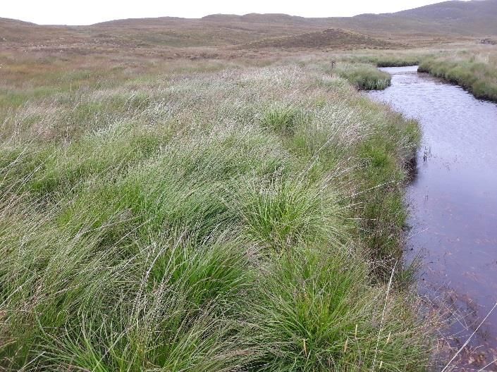
4      © Wood Group UK Limited

Annexes
Annex A Scientific Species Names
Annex B Phase 1 Habitat Survey Target Notes
Annex C Representative photographs

July 2021
Technical Appendix 8.1: Desk Study and Phase 1 Habitat Survey Report
5     © Wood Group UK Limited

1.           Introduction

1.1.1        Wood Group UK Ltd (Wood) was commissioned by SSE Renewables Developments (UK) Limited
             (SSE) to provide ecological consultancy services in relation to the proposed Achany Extension Wind
             Farm, herein after referred to as ‘the Proposed Development’.

1.1.2        This report provides the results of an ecological desk study and a Phase 1 habitat survey carried out
             during 2020. Details of the Site and Proposed Development are provided, followed by a description
             of methods employed to obtain desk study and field-based information, presentation of results,
             and a summary of findings.

1.1.3        The results of the desk study and Phase 1 habitat survey provide an update on the nature
             conservation interest of the Site and surroundings and may be used to inform the preparation of an
             Environmental Impact Assessment Report (EIAR).

1.2          Site Context
1.2.1        The Site is situated approximately 4.5 kilometres (km) north of the village of Rosehall, and
             approximately 11km west-north-west of Lairg, within The Highland Council (THC) area. It is
             positioned on the east side of Glen Cassley, approximately 1.5km from the River Cassley which runs
             parallel to the south-western part of Site. The river represents the lowest point within Glen Cassley,
             with steeply sloping land present to the east and west.

1.2.2        The elevation of the Site ranges from approximately 220 metres (m) Above Ordnance Datum (AOD)
             at Allt an Rāsail watercourse to 476m AOD at the summit of Beinn Sgeireach. Landscape within the
             Site is formed of open upland habitat. Several small hill lochs are present within the Site, which are
             drained by a network of watercourses that flow into the River Cassley catchment.

1.3          Site Design
1.3.1        The Proposed Development is a 20-turbine extension to the existing Achany Wind Farm; an
             operational 19-turbine wind farm situated to the south-east of the Site. The principle components
             of the Proposed Development include wind turbines and associate hard standings; access tracks;
             permanent LiDAR; interconnecting cables between turbines; and a welfare building and substation.
             Temporary development areas will also be required in order to facilitate a construction compound,
             concrete batching plant, and borrow pits.

1.3.2        The installed capacity and turbine dimensions will be dependent upon environmental and technical
             considerations; however, the maximum turbine tip height is up to 149.9m, delivering an installed
             capacity in excess of 80MW.

July 2021
Technical Appendix 8.1: Desk Study and Phase 1 Habitat Survey Report
6     © Wood Group UK Limited

2.           Methodology

2.1          Study Area
2.1.1        ‘The Site’ includes all land inside the red-line boundary, as displayed in Figure 8.1 (Volume 3).

2.1.2        The Phase 1 Habitat Survey Area (‘Study Area Extent’) includes the Site and a 250m buffer 1
             surrounding the red-line Site boundary.

2.2          Desk Study
2.2.1        The desk study was carried out by Wood in March 2020, in line with the Chartered Institute of
             Ecology and Environmental Management (CIEEM) best practice guidelines 2. In order to update
             potential ecological constraints against the Proposed Development, information was collected
             regarding statutory and non-statutory sites designated for nature conservation purposes (non-
             avian interest only), and protected or notable species, including those listed on the Scottish
             Biodiversity List (SBL)3 and Sutherland Biodiversity Action Plan4. The desk study features of interest
             are summarised in Table 8.1.1 below.

Table 8.1.1 Statutory and Non-Statutory Sites of Nature Conservation Value, Protected and Notable Species

    Designation             Description

    Statutory nature        Sites of international importance of relevance to this ecological study include designated Special Areas for
    conservation sites      Conservation (SAC)/Ramsar5 sites. Sites of national importance are designated as National Nature Reserves
                            (NNRs) and Sites of Special Scientific Interest (SSSI) and local sites as Local Nature Reserves (LNRs).

                            Special Areas of Conservation (SAC) – sites as defined by the Conservation (Natural Habitats, &c.) Regulations
                            1994, and the Conservation of Offshore Marine Habitats and Species Regulations 2017 are no longer part of
                            the European Union's Natura 2000 network. Instead, they form a UK-wide network of protected sites, referred
                            to in the 1994 Regulations as the UK site network, and retain the same protections.

                            Sites of Special Scientific Interest (SSSI) – these sites have been re-notified under the Wildlife and Countryside
                            Act 1981 (as amended in Scotland) and provide statutory protection for the best examples of the UK’s flora
                            and fauna;

1 In places, not all of the 250m extent were surveyed due to access restrictions.
2
  CIEEM (2018) Guidelines for Ecological Impact Assessment in the UK and Ireland: Terrestrial, Freshwater,
Coastal and Marine version 1.1. Chartered Institute of Ecology and Environmental Management, Winchester.
3 The Scottish Biodiversity List is a list of plants, animals and habitats that Scottish Ministers consider to be of principal

importance to biological conservation. https://www.gov.scot/Topics/Environment/Wildlife-
Habitats/16118/Biodiversitylist/SBL
4 The Local Biodiversity Action Plan (LBAP) that covers Achany is the Sutherland Biodiversity Action Plan, available at

https://www.caithness.org/atoz/sutherland/actionplan2003/contents.htm. This plan also forms part of the Highland
Biodiversity Action Plan 2015-2020, available at https://www.highlandenvironmentforum.info/biodiversity/action-plan/.
5
  Ramsar sites are wetlands of international importance designated under the Ramsar Convention on wetlands: an
intergovernmental treaty that aims to conserve wetlands through local and national action and international cooperation.
While there is no dedicated legislation for the protection of Ramsar sites in the UK, all Scottish Ramsar sites are either
Special Protection Areas (SPAs), Special Areas of Conservation (SACs) or Sites of Special Scientific Interest (SSSIs) and are
protected under the relevant statutory regimes.

July 2021
Technical Appendix 8.1: Desk Study and Phase 1 Habitat Survey Report
7     © Wood Group UK Limited

    Designation             Description

                            National Nature Reserves (NNRs) – these are designated under the National Parks and Access to the
                            Countryside Act 1949 or the Wildlife and Countryside Act 1981 (as amended) and contain examples of the
                            most important natural and semi-natural terrestrial and coastal ecosystems; and

                            Local Nature Reserves (LNRs) – these are areas of natural heritage that are at least locally important. Local
                            authorities select and designate LNRs under Section 21 of the National Parks and Access to the Countryside
                            Act 1949 (as amended).

    Non-statutory           These include Local Nature Conservation Sites (LNCSs) such as: Listed Wildlife Sites (LWS); Sites of
    nature                  Importance for Nature Conservation (SINC); and Local Geodiversity Sites (LGS). Non-statutory conservation
    conservation sites      sites also include Scottish Wildlife Trust (SWT) reserves such as Provisional Wildlife Sites and areas included
                            under the Ancient Woodland Inventory (AWI) or Semi Natural AWI (SNAWI). Priority Woodlands for Red
                            Squirrel are also included as non-statutory conservation sites. These non-statutory sites, which are
                            designated due to the presence of notable species or important habitats, broadly constitute the most
                            important wildlife and geological sites that do not reach the criteria required for SSSI designation.

    Protected species       Many species of animal and plant receive legal protection, which for the purposes of this study refers to:

                                 •     European Protected Species as defined within the The Conservation (Natural Habitats, &c.)
                                       Regulations 1994 (as amended) (the Habitats Regulations);

                                 •     Species included on Schedule 1, 5 and 8 of the Wildlife and Countryside Act 1981 (WCA) (as
                                       amended), excluding species that are only protected in relation to their sale; and

                                 •     Badgers, which are protected under the Protection of Badgers Act 1992, as amended by the Nature
                                       Conservation (Scotland) Act 2004.

                            These include habitats and species listed in Annex I and Annex II of the Habitats Directive as referenced in
    Priority and
    notable habitats        The Conservation (Natural Habitats, &c) Regulations, 1994 – annexes in the Habitats Directive are correct as
    and species             at 31/12/2020; thereafter any changes would need to be made/ agreed by the Scottish Government),
                            together with habitats and species which are listed on the Scottish Biodiversity List, Local Biodiversity Action
                            Plans, and/or those which are of some other conservation interest based on their status nationally, regionally
                            or locally.

2.2.2        Where possible, data for the desk study were drawn from existing ecological records and Site
             information gathered to inform the 2012 Environmental Statement (ES)6. A suite of ecological
             assessments were carried out between years 2011 and 2012 to inform the 2012 ES, including:

             ⚫    A desk-based ecological assessment;

             ⚫    A Phase 1 Habitat and National Vegetation Classification (NVC) survey;

             ⚫    Focused protected species surveys (including camera trap monitoring between June and
                  October 2011); and

             ⚫    A fish habitat survey and a freshwater pearl mussel survey.

2.2.3        In addition to ecological information available within the 2012 ES, the most recent report relating to
             the Achany Wind Farm Habitat Management Plan (HMP)7 was also reviewed to understand the
             long-term HMP objectives associated with the operational wind farm.

6
    Environ (2012). Glencassley Wind Farm Environmental Statement – July 2012, Chapter 8: Ecology
7   Applied Ecology (2020). Achany Wind Farm Habitat Management Plan – 10 year review.

July 2021
Technical Appendix 8.1: Desk Study and Phase 1 Habitat Survey Report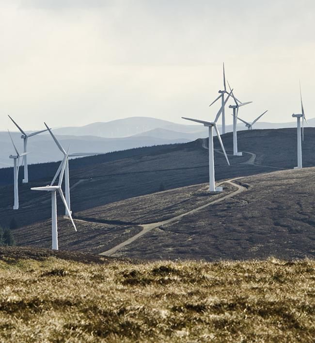
8     © Wood Group UK Limited

2.2.4        In addition to the use of existing data, a web-based search for designated sites and legally
             protected/ notable species, was also carried out as follows:

             ⚫    Information regarding statutory and non-statutory designated sites within an approximate
                  10km radius of the Site boundary was acquired using the NatureScot Sitelink web-based
                  application8;

             ⚫    Commercially available records of protected and/or notable species within 2km of the Site
                  boundary (extended to 10km for bats) recorded within the last ten years were searched within
                  the National Biodiversity Atlas (NBN) database 9;

             ⚫    A data request for records of protected and/or notable species within a 2km radius of the Site
                  boundary (extended to 10km for bats) was submitted to the Highland Biological Records Group
                  (HBRG). Analysis of species data focussed only on records made within the last ten years, as
                  older records may give an inaccurate picture of the current ecological interest within the Site
                  and the surrounding area;

             ⚫    Information regarding non-statutory designated sites within an approximate 10km radius of
                  the Site boundary was also requested from HBRG;

             ⚫    Information relating to vascular plant species records within 3km of the Site10 was requested
                  from NatureScot; and

             ⚫    Freshwater pearl mussel records were recorded from NatureScot.

             ⚫    A search to determine the potential habitats and features of interest was conducted using aerial
                  imagery (from Google Maps11 and Google Earth websites12) and 1:25:000 scale Ordnance
                  Survey maps13.

2.3          Phase 1 Habitat Survey
2.3.1        The Phase 1 habitat survey was carried out by Wood Consultant Ecologist Hannah Rowding (BSc,
             MSc, ACIEEM) between 25 May and 19 June 2020. An additional visit to map Phase 1 habitats
             present along the length of the proposed access route was carried out on 05 November 2020.

2.3.2        The Phase 1 habitat survey is a standardised technique used for classifying and mapping the
             presence of semi-natural vegetation and wildlife habitat over specified areas of land. The survey
             was conducted in accordance with standard guidance (JNCC, 2010) to establish the presence and
             distribution of habitat types within the study area. During the survey, all distinct habitats within the
             study area were identified and recorded onto a 1: 10000 OS map using Phase 1 habitat codes.
             Descriptions of key habitats present within the study area, habitat communities that overlap as a
             mosaic/ transitional area, or habitat communities that were too small to map, were also recorded in
             the form of target notes (TN).

8 https://sitelink.nature.scot/home
9 https://nbnatlas.org
10 A radius of 3km from central Ordnance Survey (OS) grid reference NC 45907 07752 was selected for the NatureScot

data request relating to vascular plant species.
11 www.maps.google.co.uk

12
   https://earth.google.com/web/
13 www.ordnancesurvey.co.uk

July 2021
Technical Appendix 8.1: Desk Study and Phase 1 Habitat Survey Report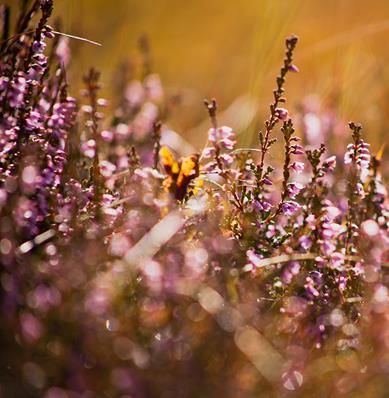
9    © Wood Group UK Limited

3.           Results

3.1.1        The scientific names of species identified during the desk study and Phase 1 habitat survey are
             presented in Annex A.

3.2          Desk Study

             Review of Existing Ecological Data

             Habitats
3.2.1        Field survey work conducted to inform the 2012 ES identified that the Study Area14 was comprised
             predominantly of wet dwarf shrub heath (formed mainly of NVC community M15) and blanket bog
             habitat (made up of M17, M18, and M19 NVC communities), both of which are classified as Annex 1
             habitat communities under the Habitats Directive.

3.2.2        The remainder of the study area contained a variety of dry dwarf shrub heath (NVC communities
             H10a and H17), marshy grassland (M25a), small patches of unimproved acid grassland (U4 and U5)
             and M6c acid flush habitat, and a network of small watercourses and lochans.

             Rare or notable plant species
3.2.3        Five UK Biodiversity Action Plan (UKBAP) Priority species15 were identified within the Study Area
             during field surveys, including: dwarf juniper, lesser butterfly orchid, alpine meadow rue, wild
             thyme, and lesser clubmoss. Of these species, only juniper and lesser butterfly orchid are listed
             within the SBL. Harebell, identified in areas of unimproved grassland on-site, is also listed within the
             SBL as a species of principle importance for conservation. Dwarf birch and alpine bearberry were
             also identified during Site surveys, which are both listed as a local priority species within the
             Sutherland LBAP.

             Protected Species
3.2.4        A review of existing ecological records gathered to inform the 2012 ES identified the following:

             ⚫    A single common pipistrelle was recorded within the Site during bat activity transect surveys
                  carried out in August and September 2011. Echolocation calls relating to common and soprano
                  pipistrelle were also detected in an area of suitable habitat (riparian woodland) positioned
                  outside the Site boundary;

             ⚫    While no evidence of otter was identified within the Site boundary, otter field signs (including
                  spraint and a resting site) were however recorded along the Allt an Dubh Loch Bhig

14 The Phase 1 habitat study area included the footprint of the original proposed wind turbines and associated access
tracks plus a 500m buffer. The NVC study area was slightly smaller, incorporating the footprint of the proposed turbines
and associated access tracks plus a 300m buffer.
15 The UK Biodiversity Action Plan (UK BAP), produced in 1994 by the UK Government, was a national strategy for the

conservation of biodiversity. The UKBAP has since been succeeded by the UK Post-2010 Biodiversity Framework (published
in 2012) which is now implemented individually by each of the four UK countries. In Scotland, habitats and species that
Scottish Ministers consider to be of principle importance for conservation are now defined within the Scottish Biodiversity
List.

July 2021
Technical Appendix 8.1: Desk Study and Phase 1 Habitat Survey Report
10     © Wood Group UK Limited

                  watercourse, located north-west of the Site, and Allt an Rasail watercourse, positioned to the
                  south of the Site;

             ⚫    Evidence of small water vole colonies were identified along several watercourses within the Site,
                  including the Allt an Dubh Loch Bhig watercourse, Dubh Loch Mor unnamed outflow, Allt an
                  Rasail watercourse, and the Allt an Leacach watercourse near the centre of Site; and

             ⚫    No evidence of wildcat, badger, or pine marten were detected during ecological walkover
                  surveys. Monitoring through use of camera traps recorded occasional sightings of badger and
                  pine marten, however these sightings were located outside of the Site boundary;

             ⚫    Fish habitat surveys identified good quality trout habitat within the Allt an Rasail watercourse,
                  the Alltan Leacach watercourse, and Allt Dail Faid watercourse. Moderate quality fish habitat
                  was identified within the Allt an Dubh Loch Mhoir, and an unnamed tributary within the Allt
                  Langwell catchment, while poor habitat quality was identified in the Allt Langwell, Allt Dubh
                  Loch Big, and Allt Bad an t-Sagairt watercourses. The main factor influencing the quality of fish
                  habitat related primarily to natural barriers and steep gradients in the area; and

             ⚫    Targeted aquatic surveys found no evidence of freshwater pearl mussels in watercourses on-
                  Site or immediately downstream.

3.2.5        In addition to ecological information presented within the 2012 ES, water vole data relating to the
             existing Achany Wind Farm HMP was considered. HMP objectives included the implementation of
             water vole habitat enhancement works, which were carried out in two main areas of Achany Wind
             Farm. Post construction monitoring for water vole has subsequently been conducted between years
             2008 and 2021.

3.2.6        Water vole activity within the habitat enhancement area adjacent to the lower reaches of Allt Sron
             nan larnachan/ start of Allt a' Bhadain was recorded consistently between 2010 and 2015, however
             this reduced to only intermittent field signs until late 2018/ early 2019. In contrast, water vole
             activity within the second habitat enhancement area (situated near the headwaters of the un-
             named tributaries of the Ghruididh Burn) was identified throughout the ten-year post-construction
             monitoring period, with all enhancement sites showing evidence of occupation or use as habitat
             corridors.

3.2.7        A review of the most recent 2021 survey records for Achany Wind Farm HMP identified the
             presence of seven discrete water vole colonies within the operational wind farm site boundary
             (Applied Ecology 2021). Water vole colonies were located along the following watercourses:

             ⚫    The Allt a' Bhadain and Allt Sron nan larnachan - positioned within 20m of the existing wind
                  farm access track at its closest point. The access track also crosses the Allt a' Bhadain near the
                  site entrance;

             ⚫    Three un-named tributaries of the Ghruididh Burn - positioned approximately 70m from an
                  operational turbine and 470m from the main wind farm access track; and

             ⚫    Adjacent to the headwaters of a further un-named tributary of the Ghruididh Burn, within the
                  north-west of the wind farm site, approximately 100m from the existing wind farm access track.

             Updated Desk Study Results
3.2.8        The results of the 2020 desk study are provided below. Note that information relating to statutory
             sites designated for ornithological conservation purposes and ornithological data records are not
             included within this report.

July 2021
Technical Appendix 8.1: Desk Study and Phase 1 Habitat Survey Report
11 © Wood Group UK Limited
Statutory and Non-Statutory Sites
3.2.9 Results of the statutory and non-statutory site search are presented in Table 8.1.2. A map detailing
the location of each site is presented in Figure 8.1 (Volume 3).
Table 8.1.2 Statutory and Non-Statutory Sites within 10km of the Site boundary
Site Designation Grid reference Area (ha) Qualifying/ notifying features Distance and
orientation
from Site
Statutory sites
Caithness & SAC NC 48118 143561.47 Blanket bog; quaking bog; wet heath; The SAC borders
Sutherlands Peatlands 11840 acid peat stained lakes and ponds; the eastern
clear water lochs with aquatic boundary of the
vegetation; marsh saxifrage; and Site
otter
Grudie Peatlands SSSI NC 48118 4778.78 Blanket bog habitat Borders the
(Component of 11840 eastern
Caithness & boundary of the
Southerland Peatlands) Site
Strath an Loin SSSI - 2342.52 Blanket bog habitat 3 km north west
(Component of of Site boundary
Caithness &
Southerland
Peatlands))
River Oykel SAC NH 52814 921.46 Atlantic salmon; 3.5km south of
98976 Freshwater pearl mussel Site access point
Kyle of Sutherland SSSI NH 54991 402.76 Flood plain fen; wet woodland; and 4km south-west
Marshes 98430 Nationally important assemblage of of Site access
plant species point
Ben Moore Assynt SSSI - 8835.90 Upland habitat assemblages; 10km north-west
Geological interest of site boundary
Non-statutory sites
Various Ancient - - In Scotland, Ancient Woodland is See Figure 8.1
Woodland defined as land that is currently
Inventory wooded and has been continually
wooded since at least 1750. Its age
means that it is important for
biodiversity and cultural identity.
Caithness and Important - - Blanket bog, vascular plant IPA overlaps
Sutherland Peatlands Plant Area assemblage, marsh saxifrage with the eastern
(IPA) boundary of the
Site
Legally Protected and Notable Species
3.2.10 The results of the data search obtained from HBRG and NBN Atlas for legally protected/ priority
species within 2km of the Site boundary (extended to 10km for bats) are presented in Table 8.1.3.
July 2021
Technical Appendix 8.1: Desk Study and Phase 1 Habitat Survey Report12 © Wood Group UK Limited
Table 8.1.3 Records of Legally Protected/ Notable Species within 2km and 10km (for bats) of the Site
Boundary (2010-2020)
Species Number Year of Details Distance and Conservation
of records most orientation from designation
recent Site
record
Daubentons 1 2011 Recorded in flight (multiple passes) during Approximately HabRegs2,
bat static detector monitoring in Achany Glen 3.6km south-east WCA5, SBL
of the proposed
Site entrance
Common 1 2011 Recorded in flight (multiple passes) during Approximately HabRegs2,
pipistrelle bat static detector monitoring in Achany Glen 3.6km south-east WCA5
of the proposed
Site entrance
Soprano 1 2011 Recorded in flight (multiple passes) during Approximately HabRegs2,
pipistrelle bat static detector monitoring in Achany Glen 3.6km south-east WCA5, SBL
of the proposed
Site entrance
Brown long- 1 2015 Found on the wall of a house in the hamlet of Approximately HabRegs2,
eared bat Gruids 3.7km north-east WCA5, SBL
of the proposed
Site entrance
Notes: HabRegs2 – Species listed within Schedule 2 of the Conservation (Natural Habitats & c) Regulations 1994; WCA 5 – Species listed
within Schedule 5 of the Wildlife and Countryside Act 1981 (as amended); SBL – Scottish Biodiversity List
3.2.11 In addition to records within the last ten years, a bat roost with a count of 100 Pipistrellus bat
species was recorded within the roof space of a building in Grudie in years 2001, 2007, and 2009
(located approximately 3.7km north-east of the proposed Site entrance).
3.2.12 Commercially available records obtained from the Bat Conservation Trust identified a Daubenton’s
hibernation roost approximately 8km south of the Site entrance, of which has been recorded on
multiple occasions between years 2011 and 2018 (BCT, 2020a). A Pipistrellus bat roost was also
located approximately 8km north-east of the Site boundary, which has been recorded on several
occasions between years 2010 and 2019 (BCT, 2020b).
Notable Plant Species
3.2.13 Vascular plant records obtained from NatureScot16 identified several notable plant species within
3km of the Site, including juniper, lesser butterfly orchid, small white orchid, holly fern, and harebell
(of which are listed within the SBL), with dwarf birch and alpine bearberry (listed within the
Sutherland LBAP) also recorded.
16
From the data obtained from NatureScot, vascular plant records from the year 1990 onwards (i.e. the last 30 years)
were considered for this study.
July 2021
Technical Appendix 8.1: Desk Study and Phase 1 Habitat Survey Report13 © Wood Group UK Limited
3.3 Phase 1 Habitat Survey
3.3.1 The results of the 2020 Phase 1 habitat survey are displayed in Figure 8.2 (Volume 3). Habitat
types identified within the Study Area are displayed in Table 8.1.4 and described in detail below.
The habitat descriptions that accompany this table should be read in conjunction with the
corresponding results map and target notes (TN) located in Annex B. Representative photographs
are provided in Annex C.
Table 8.1.4 Phase 1 Habitat Survey Results
Phase 1 Habitat Code Description Total within Study % of total Study Area
Area (Ha)
A1.2.2 Coniferous plantation woodland 60.73 3.10
A1.3.2 Mixed plantation woodland 27.14 1.39
A4.2 Recently felled woodland 0.62 0.03
B1.2 Semi-improved acid grassland 1.51 1.31
B5 Marsh/ marshy grassland 170.40 8.71
C1.1 Continuous bracken 0.45 0.02
D1.1 Dry dwarf shrub heath - acid 31.35 1.60
D2 Wet dwarf shrub heath 683.10 34.91
D5 Dry dwarf shrub heath/ acid grassland mosaic 7.99 0.41
E.1.6.1 Blanket bog 520.31 26.59
E1.7 Wet modified bog 1.12 0.06
E1.8 Dry modified bog 4.30 0.22
G1 Standing water 3.51 0.18
G2 Running water - -
J3.6 Buildings 0.07 0.00
J5 Other habitat 3.10 0.16
B1.2/B5 Acid grassland/ marshy grassland mosaic 25.62 1.31
B5/ E.16.1 Marshy grassland/ blanket bog mosaic 1.71 0.09
D1.1/ D2 Dry heath/ wet heath mosaic 9.56 0.49
D2/ B5 Wet heath/ marshy grassland mosaic 7.38 0.38
D2/ E.1.6.1 Wet heath/ blanket bog mosaic 370.56 18.94
E1.8/ B5 Dry modified bog/ marshy grassland mosaic 2.38 0.12
E1.8/ E1.6.1 Dry modified bog/ blanket bog mosaic 3.53 0.18
- Hardstanding 9.65 0.49
July 2021
Technical Appendix 8.1: Desk Study and Phase 1 Habitat Survey Report14 © Wood Group UK Limited
Phase 1 Habitat Code Description Total within Study % of total Study Area
Area (Ha)
- Not surveyed 10.45 0.53
Total 1956.53 100
Coniferous Plantation Woodland
3.3.2 A stand of coniferous plantation woodland, comprised primarily of Sitka spruce, exists to south-east
of the Study Area, on either side of the Proposed Development access track.
Mixed Plantation Woodland
3.3.3 Recently planted, native mixed woodland, of which is bordered by deer fencing, is present to the
north-west of the Study Area (TN7). Species within this young plantation include willow, birch, Scots
pine, and rowan. The vegetative ground layer within this area is comprised primarily of wet heath,
with linear stretches of marshy grassland that follow the movement of water downslope.
Semi-Improved Acid Grassland
3.3.4 A small patch of semi-improved acid grassland exists within the south-east of the Study Area,
adjacent to the Proposed Development access route. This habitat has developed on previously
disturbed ground which borders a hardstanding area - of which is used as an emergency muster
point. The abundance of species within this area was relatively sparse, with bent grass being the
most frequently occurring vegetation type.
3.3.5 Semi-improved acid grassland was also found to occur in mosaic with marshy grassland habitat.
This mosaic was recorded in damp fields used for livestock grazing near the start of the proposed
access route, to the south-east of the Study Area.
Marshy Grassland
3.3.6 Marshy grassland habitat was common throughout the Study Area. It was found adjacent to
watercourses, within damp areas, and stretches across hillslopes in linear bands following the
pattern of water movement downslope. Species within this habitat were generally dominated by
either soft rush (with frequent marsh violet, marsh bedstraw, and tormentil) or purple moor grass
(with frequent bog asphodel and tormentil, with cross leaved heath, deer grass, and heath milkwort
as occasional associates).
Continuous Bracken
3.3.7 A small stand of continuous bracken is present along the south-western edge of the Allt a Bhadain
watercourse within the south-east of the Study Area.
Heath
Dry Dwarf Shrub Heath
3.3.8 Dry dwarf shrub heath exists in small patches throughout the Study Area – typically located in areas
of shallower peat with improved drainage capacity, and on steep, rocky outcrops. This habitat
community was characterised by a dominance of ling heather, frequent heath rush and bell heather,
July 2021
Technical Appendix 8.1: Desk Study and Phase 1 Habitat Survey Report15 © Wood Group UK Limited
and occasional to frequent bilberry. The bryophyte layer was comprised primarily of hypnoid moss
species, such as heath-plait moss, glittering wood moss, and red-stemmed feather moss. To the
north-west of the Study Area, wild thyme was found to be present within the dry heath habitat
(TN33).
3.3.9 On more exposed, higher altitude hillslopes, heath habitat was formed of primarily of prostrate
heather, deer grass, woolly fringe moss, fir clubmoss, and a variety of lichen species. Dwarf juniper
was also recorded on some hilltops (TN34).
Wet Dwarf Shrub Heath
3.3.10 This community is the most widely distributed habitat within the Study Area, covering 34.91% of
land surveyed. In some areas, ling heather tended to dominate, with abundant cross-leaved heath
and deer grass, and frequent common cotton grass, Cladonia lichen, purple moor grass, bog
asphodel, and purple spoonwort. Occasional associates included lousewort, Sphagnum capillifolium,
and glittering wood moss (e.g. TN1).
3.3.11 In other areas, wet heath was characterised by a dominance of deer grass, with an abundance of
Cladonia lichen species and prostrate heather. Heath rush, purple moor grass, woolly fringe moss,
and fir club moss were also frequently occurring species, with Sphagnum capillifolium as an
occasional associate (e.g. TN18 and TN29).
Dry Dwarf Shrub Heath/ Acid Grassland Mosaic
3.3.12 Small patches of dry heath/ acid grassland mosaic were identified in areas of steeper slope with
more freely draining soils (e.g. TN3). A variety of species are present within this mosaic habitat,
including an abundance of ling heather, sweet vernal grass, and heath bedstraw, with frequent
wavy hair grass, bent grass, tormentil, heath milkwort, yarrow, and glittering wood moss.
Mire
Blanket Bog
3.3.13 Blanket bog contributes a large proportion of habitat within the Study Area (26.59%). Pockets of
blanket bog habitat are scattered across the north-west of the Study Area, with more extensive
bands spread across the lower slopes of Carn nam Bo Maola to Loch Sgeireach. Blanket bog habitat
is also present throughout the south-east of the Study Area.
3.3.14 Variations in the abundance and distribution of typical mire species were recorded within blanket
bog habitat throughout the Study Area. For example, in some areas, hares tail cotton grass and ling
heather were abundant, with frequent bilberry, cloudberry, glittering wood moss, red-stemmed
feather moss, and occasional crowberry and Sphagnum capillifolium (e.g. TN15 and TN19). While in
other areas, a dominance of deer grass and Sphagnum moss species were recorded, with frequent
ling heather, Cladonia lichen, and cross-leaved heath (e.g. TN20).
3.3.15 Within the south-east of the Study Area, much of the blanket bog habitat was noted to contain
linear drainage channels, of which may be contributing to dewatering of surrounding bog habitat
(e.g. TN 4). Some of the drainage channel sides were comprised of pare peat with water flowing
freely downgradient, while other drainage channels were noted to contain slow flowing water and
were subject to a degree of occlusion by Sphagnum moss species.
July 2021
Technical Appendix 8.1: Desk Study and Phase 1 Habitat Survey Report16 © Wood Group UK Limited
Dry Modified Bog
3.3.16 Small patches of dry modified bog were identified adjacent to minor watercourses/ drainage
channels within the Study Area (e.g. TN12). This habitat type was characterised by dense hummocks
of hares tail cotton grass and glittering wood moss, with frequent ling heather, heath bedstraw,
bilberry, tormentil, and occasional patches of Sphagnum capillifolium scattered throughout. The
presence of dry modified bog is likely to be related to dewatering of blanket bog habitat
immediately adjacent to drainage channels, resulting in a reduction in mire species associated with
more waterlogged conditions (such as Sphagnum moss species) and an increased presence of
species that are tolerant of drier conditions (such as hypnoid mosses).
Waterbodies
Standing Water
3.3.17 Several small lochans are present within the Study Area, including Loch Sgeireach and Loch an
Rasail.
Running Water
3.3.18 Several watercourses and associated minor tributaries intersect the Study Area. To the north-west,
the Allt an Leacach borders the Site boundary, while the Allt Bad na t-Sagairt flows between the
slopes of Beinn Sgeireach and Cārn nam Bō Maola. Further to the south-east lies the Allt an Rāsail.
These watercourses were generally around 2-3m wide, with a stony/ peaty base. Tributaries
associated with these watercourses were narrow (up to 1m wide), and often bordered by marshy
grassland habitat.
Buildings
3.3.19 The existing Achany Wind Farm substation represents the only building within the Study Area.
Other Habitat
3.3.20 The term ‘other habitat’ has been applied to an area of land to the south-east of the Study Area, of
which may have been excavated as a borrow pit for the existing Achany Wind Farm and is now
recolonising with a range of species (TN 25). Around the edge of the pit is very short vegetation
that has been subject to browsing. Species present include abundant tufts of soft rush, with bent
grass, common haircap moss, glittering wood moss and heavily grazed ling heather throughout.
Within the damp hollow at the base of the pit, hares tail cotton grass, soft rush, and star sedge are
common.
Hardstanding
3.3.21 To the far south-east of the Study Area is an area of hardstanding, with access tracks and turbine
infrastructure associated with the existing Achany Wind Farm.
July 2021
Technical Appendix 8.1: Desk Study and Phase 1 Habitat Survey Report17 © Wood Group UK Limited
4. Summary of Nature Conservation Interest
4.1 Desk Study
4.1.1 The desk-based ecological study was carried out to identify any potential ecological constraints to
the Proposed Development. A summary of the assessment findings is provided below:
⚫ Several statutory sites designated for the purpose of nature conservation have been identified
within 10km of the Site boundary. Those with potential connectivity to the Site include;
River Oykel SAC, designated primarily due to the presence of freshwater pearl mussel, with
Atlantic salmon also a qualifying feature; and
Caithness and Sutherland Peatland SAC and its two component SSSIs (Strath an Loin SSSI
and Grudie Peatlands SSSI), designated for peatlands (including blanket bog) and otter.
⚫ Non-statutory sites comprise woodland habitat classified within the Ancient Woodland
Inventory. No further information relating to non-statutory designated sites was obtained from
HBRG.
⚫ Data records form the last ten years show three species of bat (common pipistrelle, soprano
pipistrelle, and Daubentons bat) recorded in flight within 10km of the Site boundary. Records
indicating the presence of roosting bats (common pipistrelle, Daubenton’s bat, and brown long
eared bat) between 3.7 and 8.5km of the Site boundary also exist.
⚫ Habitats within the Site are comprised primarily of wet heath and blanket bog (Habitats Directive
Annex I habitat type), with smaller areas of dry dwarf shrub heath, unimproved acid grassland,
and acid flush habitat also present. Several plant species of principle importance for nature
conservation (e.g. listed within the SBL) were also identified during Phase 1 habitat and NVC
surveys.
⚫ Based on existing baseline information, potential exists for otter to utilise the Site for foraging,
commuting and sheltering purposes.
⚫ Small water vole colonies have previously been recorded within the Site. In addition, six water
vole colonies have been identified within the adjacent operational Achany Wind Farm site
boundary. Therefore, potential exists for their continued presence within the Study Area.
⚫ Two species of bat (common and soprano pipistrelle) were recorded within, or adjacent to, the
Site during activity surveys in 2011. Potential therefore exists for these species to utilise the Site
for commuting and foraging purposes.
4.2 Phase 1 Habitat Survey
4.2.1 Habitats within the Study Area are comprised primarily of wet heath, with large areas of blanket
bog habitat and marshy grassland scattered throughout. Several watercourses and small
waterbodies also intersect the Study Area. The distribution of habitat communities tends to reflect
the acidity and drainage of underlying soils, variations in gradient, and likely differences in peat
depth across the Study Area.
4.2.2 While some habitats present within the Study Area are generally considered to be of low ecological
importance (such as coniferous plantation forestry, semi-improved acid grassland, and bracken)
habitats of higher nature conservation value were also recorded, which are discussed below.
July 2021
Technical Appendix 8.1: Desk Study and Phase 1 Habitat Survey Report18 © Wood Group UK Limited
Species of interest
4.2.3 A number of species that are listed within the SBL and Sutherland LBAP were recorded within the
Study Area. Those defined within the SBL, and thus of principle importance for biodiversity
conservation include:
⚫ Dwarf juniper
4.2.4 Those listed within the Sutherland LBAP, and therefore of local importance for biodiversity
conservation, include:
⚫ Dwarf birch; and
⚫ Alpine bearberry
Habitats of interest
4.2.5 Several habitats of importance for nature conservation were recorded during the survey and have
been subject to further survey as part of the National Vegetation Classification, Peatland Condition
Assessment and GWDTE Report (Technical Appendix 8.2A), and have been considered as part of
the design phase:
Annex 1 habitat
4.2.6 Blanket bog and dry and wet dwarf shrub heath are listed under Annex 1 of the Council Directive
92/43/EEC on the conservation of natural habitats of wild fauna and flora (the Habitats Directive).
These habitats are also listed within the SBL and Sutherland LBAP. As such, they are considered as
habitats of principle importance for biodiversity conservation.
Waterbodies
4.2.7 A series of watercourses, bog pool areas, and lochans are present within the Study Area. Rivers and
lochs are listed within the SBL and Sutherland LBAP and are therefore a priority habitat for
conservation.
Ground Water Dependant Terrestrial Ecosystems
4.2.8 Groundwater Dependant Terrestrial Ecosystems (GWDTEs) are wetland habitats that depend on
groundwater flows or chemistries. Potential for the presence of GWDTEs exists within habitats
identified throughout the Study Area. In accordance with SEPA (2017) guidelines, a detailed NVC
survey and GWDTE assessment has been undertaken (Technical Appendix 8.2A; and Chapter 10:
Hydrology and Hydrogeology) to further inform the potential for GWDTEs, and thus assess the
potential risk to these habitats as a result of construction operations.
July 2021
Technical Appendix 8.1: Desk Study and Phase 1 Habitat Survey Report19 © Wood Group UK Limited References Applied Ecology (2020). Achany Wind Farm Habitat Management Plan – 10 year review. Bat Conservation Trust (2020a) National Bat Monitoring Programme - Hibernation Survey. Bat Conservation Trust (2020b). National Bat Monitoring Programme Roost Count. Environ (2012). Glencassley Wind Farm Environmental Statement – July 2012, Chapter 8: Ecology JNCC, 2010. Handbook for Phase 1 habitat survey - a technique for environmental audit, ISBN 0 86139 636 7 SEPA (2017). Guidance on Assessing the Impacts of Development Proposals on Groundwater Abstractions and Groundwater Dependent Terrestrial Ecosystems. SEPA Guidance Note 31. July 2021 Technical Appendix 8.1: Desk Study and Phase 1 Habitat Survey Report
A1      © Wood Environment & Infrastructure Solutions UK Limited

Annex A
Scientific Species Names

 Common name                                                           Scientific name

 Alpine bearberry                                                      Arctostaphylos alpina

 Alpine meadow rue                                                     Thalictrum alpinum

 Atlantic salmon                                                       Salmo salar

 Badger                                                                Meles meles

 Bell heather                                                          Erica cinerea

 Bent grass species                                                    Agrostis sp.

 Birch                                                                 Betula sp.

 Bilberry                                                              Vaccinium myrtillus

 Bog asphodel                                                          Narthecium ossifragum

 Bracken                                                               Pteridium sp.

 Brown long-eared bat                                                  Plecotus auritus

 Cladonia lichen                                                       Cladonia sp.

 Common cotton grass                                                   Eriophorum angustifolium

 Common haircap moss                                                   Polytrichum commune

 Common pipistrelle bat                                                Pipistrellus pipistrellus

 Cross leaved heath                                                    Erica tetralix

 Daubenton’s bat                                                       Myotis daubentonii

 Deer grass                                                            Trichophorum germanicum

 Dwarf birch                                                           Betula nana

 Dwarf juniper                                                         Juniperus communis

 Fir clubmoss                                                          Huperzia selago

 Freshwater pearl mussel                                               Margaritafera margaritafera

 Glittering wood moss                                                  Hylocomium splendens

 Harebell                                                              Campanula rotundifolia

 Hares tail cotton grass                                               Eriophorum vaginatum

 Heath bedstraw                                                        Galium saxatile

 Heath milkwort                                                        Polygala serpyllifolia

July 2021
Technical Appendix 8.1: Desk Study and Phase 1 Habitat Survey Report
A1      © Wood Environment & Infrastructure Solutions UK Limited

 Common name                                                           Scientific name

 Heath plait moss                                                      Hypnum jutlandicum

 Heath rush                                                            Juncus squarrosus

 Holly fern                                                            Polystichum lonchitis

 Lesser butterfly orchid                                               Platanthera biofolia

 Lesser clubmoss                                                       Selaginella selaginoides

 Ling heather                                                          Calluna vulgaris

 Lousewort species                                                     Pedicularis sp.

 Marsh bedstraw                                                        Galium palustre

 Marsh violet                                                          Viola palustris

 Otter                                                                 Lutra lutra

 Pine marten                                                           Martes martes

 Purple moor grass                                                     Moliniea caerulea

 Purple spoonwort                                                      Pleurozia purpurea

 Red stemmed feather moss                                              Pleurozium schreberi

 Rowan                                                                 Sorbus aucuparia

 Scots pine                                                            Pinus sylvestris

 Sitka spruce                                                          Picea sitchensis

 Small white orchid                                                    Pseudorchis albida

 Soft rush                                                             Juncus effusus

 Soprano pipistrelle bat                                               Pipistrellus pygmaeus

 Sphagnum capillifolium                                                Sphagnum capillifolium

 Star sedge                                                            Carex echinata

 Sweet vernal grass                                                    Anthoxanthum odouratum

 Tormentil                                                             Potentilla erecta

 Water vole                                                            Arvicola amphibius

 Wavy hair grass                                                       Deschampsia flexuosa

 Wildcat                                                               Felis sylvestris

 Wild thyme                                                            Thymus polytrichus

 Willow                                                                Salix sp.

July 2021
Technical Appendix 8.1: Desk Study and Phase 1 Habitat Survey Report
A1      © Wood Environment & Infrastructure Solutions UK Limited

 Common name                                                           Scientific name

 Woolly fringe moss                                                    Racomitrium lanuginosum

 Yarrow                                                                Achillea millefolium

July 2021
Technical Appendix 8.1: Desk Study and Phase 1 Habitat Survey Report
A1      © Wood Environment & Infrastructure Solutions UK Limited

Annex B
Phase 1 Habitat Survey Target Notes

 TN         Grid reference             Description

 1          NC 46320 06689             Wet heath habitat on shallow peaty soil. In some areas vegetation is rather sparse, with bare peat
                                       showing. Ling heather is dominant, with abundant deer grass and crossed leaved heath, with
                                       frequent common cotton grass, Cladonia lichen, purple moor grass, bog asphodel, and hares tail
                                       cotton grass. Lousewort species and Sphagnum capillifolium were occasional associates.

 2          NC 46613 06868             Patch of rather dry bog habitat on hillside. Characterised by hummocks of hares tail cotton grass
                                       glittering wood moss and red stemmed feather moss, with frequent purple moor grass and cross
                                       leaved heath, and patchy Sphagnum moss in hollows.

 3          NC 46428 06956             Small hillock of dry heath-acid grassland mosaic, with sweet vernal grass, tormentil, bent grass,
                                       yarrow, heath bedstraw, ling heather, and glittering wood moss.

 4          NC 46333 07360             Many drainage ditches in this area – some of which have water moving downgradient and sides of
                                       bare peat, while others have slow flowing water and some degree of occlusion by Sphagnum moss.

 5          NC 46972 07037             Patch of shallower peat here with less hares tail cotton grass and increased coverage of common
                                       cotton grass, deer grass, and woolly fringe moss. Ling heather is also frequent, and bare patches of
                                       peat are visible.

 6          NC 46863 06680             Dry modified bog habitat to the west of proposed Tower 17. Pronounced hummock and hollow
                                       landscape. Hares tail cotton grass and hypnoid moss dominate hummocks, with heath bedstraw,
                                       bilberry, tormentil, ling heather and patchy Sphagnum capillifolium also frequent.

 7          NC 44114 10497             Young mixed native woodland plantation comprising willow, birch, Scots pine, and rowan.

 8          NC 44219 10733             Patches of dry heath habitat amongst purple moor grass mire and wet heath. Vegetation within dry
                                       heath is dominated by ling heather, with abundant heath plait moss and frequent heath rush, deer
                                       grass, bilberry, bell heather, red-stemmed feather moss and glittering wood moss.

 9          NC 43989 11931             Area previously marked as marshy grassland, however have classified as blanket bog due to the
                                       dominance of hares tail cotton grass, abundance of Sphagnum moss, and frequent occurrence of
                                       purple moor grass, cross-leaved heath, deer grass, heath milkwort, and ling heather.

 10         NC 46619 06503             Area of wet heath/ purple moor grass mire with abundant deer grass, bog myrtle and purple moor
                                       grass, with frequent heath milkwort, cross-leaved heath, tormentil, and occasional bog asphodel,
                                       Sphagnum papillosum, star sedge, and ling heather.

 11         NC 46773 06397             Area marked as marshy grassland due to the high cover of purple moor grass. However there is a
                                       relatively diverse range of species in the sward, including abundant cross-leaved heath and
                                       tormentil, with frequent bog myrtle, scabious species, and deer grass.

 12         NC 47046 06182             Dry modified bog habitat - hares tail cotton grass and wavy hair grass dominate, with abundant
                                       heath bedstraw and hypnoid moss species. Sprigs of dried out ling heather present, with frequent
                                       tormentil, bilberry, purple moor grass, and occasional deer grass.

 13         NC 47344 06482             Drainage ditches present throughout bog habitat, with water flowing downgradient.

 14         NC 47403 06332             Watercourse measures approximately 0.3-0.75m wide, with a channel depth of 0.5-0.75m.

 15         NC 47280 06243             Area adjacent to watercourse is comprised predominantly of bog habitat with hummocks of hares
                                       tail cotton grass and wavy hair grass, with crowberry, bilberry, hypnoid moss, and Sphagnum fallax
                                       and Sphagnum capillifolium in hollows. A linear marshy grassland feature is also present, of which is

July 2021
Technical Appendix 8.1: Desk Study and Phase 1 Habitat Survey Report
A1 © Wood Environment & Infrastructure Solutions UK Limited
TN Grid reference Description
dominated by soft rush, with frequent marsh violet, tormentil, common haircap moss, common
sorrel, marsh bedstraw, and occasional meadow buttercup.
16 NC 48041 05980 Habitat on hilltop is comprised of relatively shallow peat (up to 50cm deep), however vegetation is
more typical of blanket bog - dominated by hares tail cotton grass, with abundant deer grass,
Cladonia lichen species, woolly fringe moss, and prostrate heather, and frequent crossed leaved
heath and Sphagnum capillilfolium.
17 NC 49487 04778 Previously felled area with scattered lodgepole pine regeneration and plant species such as wavy
hair grass, purple moor grass, ling heather, deer grass, hypnoid moss species, and occasional hares
tail cotton grass.
18 NC 49789 04589 Heath habitat in which deer grass is dominant, with abundant Cladonia lichen species and prostrate
heather, and frequent heath rush, purple moor grass, and woolly fringe moss. Dwarf birch is also
frequent in this location.
19 NC 49966 04485 Blanket bog habitat in which hares tail cotton grass, ling heather, Cladoina lichen species, and
Sphagnum capillifolium are abundant, with frequent cross-leaved heath, woolly fringe moss, and
occasional common cotton grass.
20 NC 50017 04527 Blanket bog near base of slope more typical of M17 mire community – vegetation dominated by
deer grass, with abundant Sphagnum moss species and Cladonia lichen species, with frequent ling
heather and cross leaved heath.
21 NC 50051 04559 Alpine bearberry abundant within transitional bog habitat near the base of the slope.
22 NC 50379 04759 Hilltop has been classified as wet heath/ blanket bog mosaic as there are patches of wet heath
dominated by deer grass and also transitional vegetation with hares tail cotton grass. On the steep
north-east side of the slope, vegetation is comprised of abundant hares tail cotton grass, ling
heather, hypnoid moss species, and crowberry, with frequent Cladonia lichen species and alpine
bearberry.
23 NC 50815 04045 Vegetation surrounding peat is a mixture of species that have colonised first. For example – dry
heath species on stony shallow soils, scattered patches of common cotton grass, and areas of
dense purple moor grass and frequent tufts of hares tail cotton grass.
24 NC 52511 03734 Hardstanding area with made up ground surrounding it, in which acid grassland species have
began to develop. Vegetation is very short due to browsing pressure.
25 NC 52714 03583 Old borrow pit with reclaimed ground surrounding the perimeter. Around the edge is very short
vegetation due to browsing, with abundant tufts of soft rush throughout. Species present include
bent grass, common haircap moss, glittering wood moss, and heavily grazed ling heather. Within
damp hollow at base of the pit, hares tail cotton grass, soft rush, and star sedge are common.
26 NC 53028 02955 Watercourse measures approximately 1m wide by 30cm deep. Good otter commuting and foraging
potential.
27 NC 53476 02468 Open habitat near base of access track with purple moos grass, tufted hair grass and soft rush. This
habitat is suitable for water vole, and also has otter commuting and foraging potential.
28 NC 445992 10997 Area of heavily eroded peat and bare ground
29 NC 46272 10054 Area of heath on top of hill, in which deer grass is dominant, while woolly fringe moss, Cladonia
lichen species, purple spoonwort and prostrate heather are all frequent.
30 NC 44603 11155 Bog pool - measuring approximately 12x6m
31 NC 44089 10973 Land north and west of the met mast if formed of a mosaic of blanket bog and wet heath habitat.
July 2021
Technical Appendix 8.1: Desk Study and Phase 1 Habitat Survey ReportA1 © Wood Environment & Infrastructure Solutions UK Limited
TN Grid reference Description
32 NC 44445 11691 Strip of dry heath – acid grassland habitat with abundant ling heather, sweet vernal grass, and
heath bedstraw, with frequent wavy hair grass, bent grass species, tormentil, heath milkwort, and
yarrow.
33 NC 44529 12131 Dry heath habitat in which wild thyme is frequent throughout.
34 NC 45303 11917 Top of Beinn Sgeireach is dominated by heath among rocky outcrops. Within this area, deer grass
dominates, with abundant Cladonia lichen species, frequent purple spoonwort, heath rush, and
woolly fringe moss, and occasional fir clubmoss. Dwarf juniper was also observed at NC 45303
11914.
35 NC 45419 11746 Patch of blanket bog within a hummock on east side of hill, in which hares tail cotton grass and ling
heather are abundant, with frequent bilberry and cloudberry, and occasional occurrence of
crowberry and Sphagnum capillifolium.
July 2021
Technical Appendix 8.1: Desk Study and Phase 1 Habitat Survey ReportA1 © Wood Environment & Infrastructure Solutions UK Limited
Annex C
Representative photographs
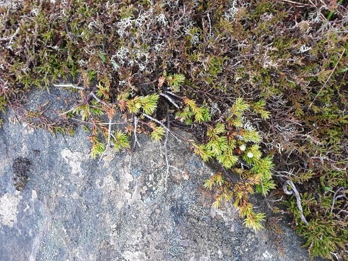
Photo 1: Marshy grassland habitat adjacent to watercourse Photo 2: Dry heath- acid grassland mosaic
Photo 3: Dry modified bog habitat Photo 4: Example of historic drainage ditch intersecting blanket
bog habitat
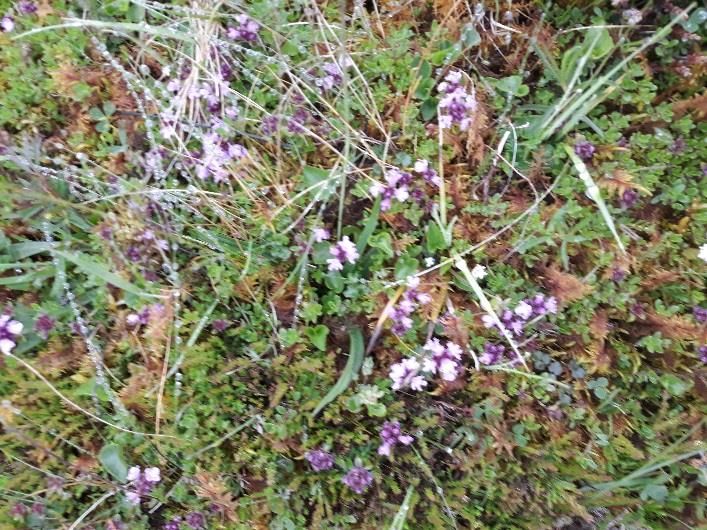
Photo 5: Dwarf juniper on hill top Photo 6: Wild thyme within dry heath habitat
July 2021
Technical Appendix 8.1: Desk Study and Phase 1 Habitat Survey ReportJune 2021 Technical Appendix 8.1: Desk Study and Phase 1 Habitat Survey Report
You can also read