Whitireia Park Management Plan - and Whitireia Park Bylaws 2016 - Greater Wellington ...
←
→
Page content transcription
If your browser does not render page correctly, please read the page content below
Whitireia Park Management Plan
and Whitireia Park Bylaws 2016

Whitireia Park Management Plan and
    Whitireia Park Bylaws 2016

                                     Whitireia Park Management Plan 2016
       Whitireia Park Board

       Ngäti Toa Rangatira

                                         1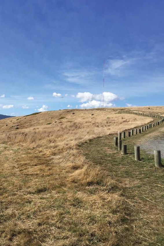
Whitireia Park Management Plan 2016

Message from the Park Board

The Whitireia Park Management Plan outlines a positive vision for the
park and directions for management over the next 10 years. It updates and
replaces the plan developed in 1978, and was developed with significant
input from local groups and others who submitted comments during the
plan development and public feedback stages.

The Plan recognises the significant cultural and natural heritage features of
the park and outlines a range of policies and proposals to guide management
activities and improve facilities for park visitors. These improvements
include upgrading the Kaitawa Pou car park, landscaping and adding panels
to reveal park stories, installing picnic tables in the Onehunga and Kaitawa
Bay areas, and development of a shared use track to offer an alternative
access route to the road to Onehunga Bay for walkers and cyclists.

Proposals to improve the parks’ natural environment include restoration plantings to connect forest
remnants and a range of weed removal and pest animal management works. The Plan also includes updated
bylaws which outline rules for activities. For example, to help minimise the threat of damaging fires in the
park, only gas barbeques will be permitted in the park.

                                                                                                               Whitireia Park Management Plan 2016
Development of this new plan is an important milestone in the park’s history and it provides sound
directions for mangement of this well-loved park.

Cr Barbara Donaldson

Chair, Whitireia Park Board

                                                                                                                   3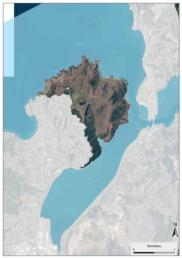
Contents
                                              Message from the Park Board                                              3
                                              Mihi		                                                                   6
                                              Definitions	                                                             6
                                      Section 1: Introduction                                                          9
                                              The rationale for the plan and process for its development	              9
                                              Moemoeā - Vision described	                                              9
                                              How to use the plan	                                                    10

                                      Section 2: Background                                                           13
                                              Kōrero Tuku Iho: Cultural and Historical Associations	                  13
                                              Early Māori occupation of land and harbour	                             13
                                              The lead up to alienation of land in Porirua	                           14
Whitireia Park Management Plan 2016

                                              Gifting and subsequent loss	                                            15
                                              Treaty settlement and implications for Whitireia (all recent events)	   16
                                              Archaeological sites	                                                   16
                                              Radio New Zealand installation	                                         18
                                              Location and physical context	                                          18
                                              Land tenure and control (include legal descriptions as a table)	        19
                                              Creation of the park	                                                   20
                                              Management of the park	                                                 21
                                              Landscape character	                                                    23
                                              Geology	                                                                25
                                              Soils	                                                                  25
                                              Ecological Context and management	                                      25
                                              Te Awarua-o-Porirua Harbour, waterways and wetlands	                    27
                                              Biodiversity: Flora	                                                    28
                                              Biodiversity: Fauna	                                                    29
                                              Restoration	                                                            30
                                              Threats	                                                                30
                                              Weeds	                                                                  30
                                              Pest animals	                                                           31
                                              Fire risk and recreation	                                               31
                                              Climate Change and sea level rise	                                      32

                4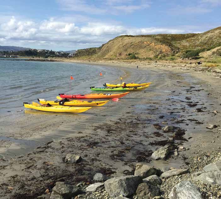
Section 3: Objectives, Policies and actions	                                                          35
           OBJECTIVE 1: An improvement of native habitats through regeneration, active
                             restoration and building green connections.	                             36
           OBJECTIVE 2: Pest plants and animals are reduced to result in measureable ecosystem
                             improvements37
           OBJECTIVE 3: Land management in the Onepoto catchment results in positive
                             environmental contribution to the health of the
                             Te Awarua-o-Porirua Harbour.	                                            37
           OBJECTIVE 4: Open space is managed for its recreation and amenity value, and to
                             ensure preservation of archaeological sites. Management will give
                             rise to in an increased appreciation of the area.                        38
           OBJECTIVE 5: Risks from fire and other human induced/influenced hazards to the park
                             environment and visitors are reduced over time	                          40

                                                                                                            Whitireia Park Management Plan 2016
           OBJECTIVE 6: Radio New Zealand’s broadcasting function is not inhibited and
                             that new network facilities do not compromise the amenity and
                             functioning of the park.                                                 41
           OBJECTIVE 7: The community’s awareness of the values within the park is improved
                             and that this is demonstrated through care of the environment and
                             infrastructure.	                                                         42
           OBJECTIVE 8: Recreation and leisure activities are supported by tracks and other
                             facilities that are in keeping with the natural and cultural setting.	   43
           OBJECTIVE 9: Kaitiakitanga starts with mana whenua and extends through all
                             parts of the community.	                                                 45
           OBJECTIVE 10: Best practice in park management is provided.	                               47

Section 4: Activity rules and the process to consider new developments	                               51
        Introduction	                                                                                 51
        4.1 Allowed activities                                                                        51
        4.2 Managed activities                                                                        53
        4.3 Restricted activities                                                                     53
        4.3.1 Public notification:                                                                    53
        4.3.2 Information required with application                                                   53
        4.3.3 Application timeframe	                                                                  54
        4.3.4 Decision making guidelines	                                                             54
        4.3.5 Restricted activities, imposition of conditions	                                        54
        4.4 Prohibited activities	                                                                    55

Section 5: Whitireia Park Bylaws 2015	                                                                57
        Appendix 1: Land tenure, within and adjacent to Whitireia Park	                               63
        Appendix 2: References                                                                        65
        Appendix 3                                                                                    67
                                                                                                                5
Mihi
                                      E ngā mana, e ngā reo, e ngā karangatanga maha kei waenganui i a koutou, nau mai, haere mai ki
                                      raro i te korowai mahana nei o Ngāti Toa Rangatira.

                                      He mihi tēnei ki a koutou katoa o te hāpori nei o Porirua. He mea taketake ana ki a tātou katoa
                                      o te rohe nei, ko te āhua me te orange o te takiwa ara ko Whitireia ki a Porirua. E whai ake nei
                                      ētehi “Tatai Whakahaere me ētehi Pāero” e pa ana ki Whitireia hei hāpai i ngā mahi e pā ana ki te
                                      manaaki, e pā ana ki te āta tiaki i tēnei taonga puiaki o tātou.

                                      Greetings to the many peoples, to the many voices, and to the many affiliations that we share
                                      together within our community of Porirua. Ngāti Toa Rangatira extends a warm welcome to you
                                      all. The Whitireia Park Management Plan and Bylaws aim to sustainably manage and develop the
                                      area as an important Taonga to Ngāti Toa Rangatira and all people within our local and extended
                                      communities. The following Whitireia Park “Management Plan and Bylaws” outlines a number of
                                      objectives and activities for the long-term enjoyment and sustainability of this unique and precious
                                      resource.

                                      Definitions
Whitireia Park Management Plan 2016

                                      Amenity value - the physical, functional, cultural and spiritual characteristics of a place or landscape that
                                      people find attractive and/or gain enjoyment from
                                      Ecological district - a local part of New Zealand where the topographical, geological, climatic, soil and
                                      biological features, including the broad cultural pattern, produce a characteristic landscape and range of
                                      biological communities (Source: DOC Ecological regions and districts of New Zealand, 1987).
                                      Ecological region - an aggregation of adjacent ecological districts with closely related characteristics (Source:
                                      DOC Ecological regions and districts of New Zealand, 1987).
                                      Habitat restoration - the rehabilitation of habitats to support indigenous flora and fauna, ecosystem
                                      functions and natural processes that would naturally occur in the ecosystem and locality (Source: GWRC
                                      Proposed Natural Resources Plan, 2015).

                                      kai moana - seafood
                                      kaitiaki - guardian, caretaker, trustee
                                      kaitiakitanga - guardianship, the act of taking care
                                      Key Native Ecosystem - an ecosystem managed under the GWRC Key Native Ecosystem Programme.
                                      Key Native Ecosystems are managed to ensure the protection of the full range of terrestrial and freshwater
                                      biodiversity in the Wellington region. Management of sites can include control of ecological weeds and pests,
                                      fencing to exclude stock, restoration planting, and assistance with legal protection.
                                      Local native species - in this plan, a species which occurs naturally in the Sounds-Wellington ecological
                                      region (encompassing Wellington and Cook Strait ecological districts).
                                      Native species - a plant or animal species which occurs naturally in New Zealand. A synonym is
                                      “indigenous”. (Source: NZ Biodiversity Strategy, 2000)
                                      Native weed species - native plants which are capable of causing at some time a serious adverse and
                                      unintended effect in relation to the survival and distribution of other indigenous plants or indigenous
                                      animals, or the sustainability of natural and developed ecosystems (Source: GWRC Regional Pest
                                      Management Strategy, 2002).
                                      Non-local native species - in this plan, a species which occurs naturally in New Zealand but not the Sounds-
                                      Wellington ecological region.
                                      manakitanga - hospitality
                                      mana whenua - tribe that is recognised as having guardianship of an area
                                      moemoeā - vision
                                      manuhiri - visitors

                6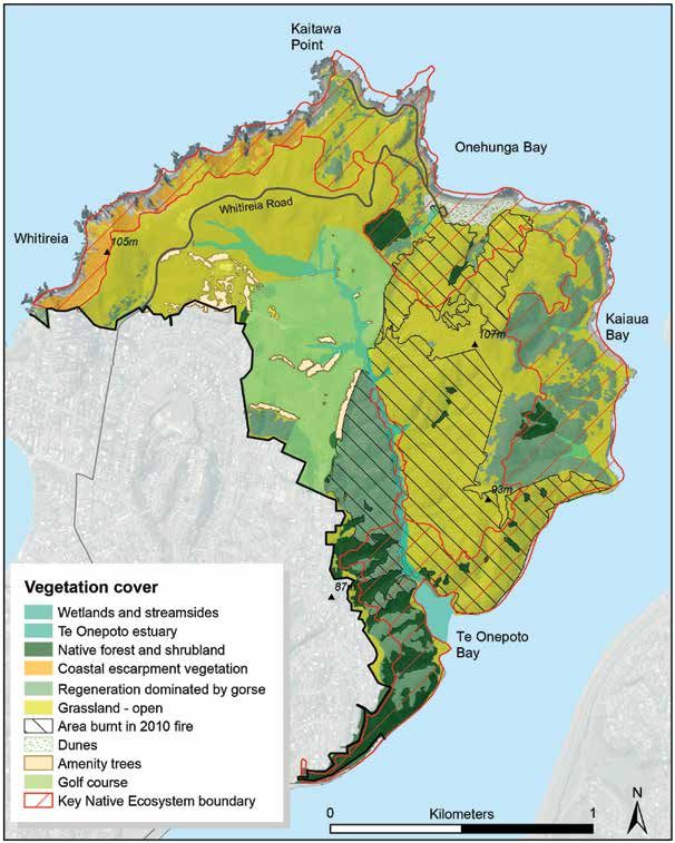
Pāero - bylaws
pēpeha/whakatauki - proverb or motto
Pest animal species - animals which are capable of causing at some time a serious adverse and unintended
effect in relation to the survival and distribution of indigenous plants or animals, or the sustainability of
natural and developed ecosystems (Source: GWRC Regional Pest Management Strategy, 2002).
rohe - tribal area
taonga - treasure
Ruataki Whakahaere/Tatai Whakahaere - management plan
urupā - cemetery
Weed species - plants which are capable of causing at some time a serious adverse and unintended effect in
relation to the survival and distribution of indigenous plants or animals, or the sustainability of natural and
developed ecosystems (Source: GWRC Regional Pest Management Strategy, 2002).
whenua - land

                                                                                                                  Whitireia Park Management Plan 2016

                                                                      Onehunga Bay is a popular launch and
                                                                      stopping-off place for sea kayakers
Whitireia Park Management Plan 2016

    1: Introduction
The rationale for the plan and process for its
development
Areas designated reserves under the Reserves
Act 1977 require a management plan to direct Toka-a-Papa
the maintenance, protection and preservation of Reef
an area, ensuring that its use and enjoyment are Plimerton
provided for (Reserves Act Section 41(3), authors
paraphrase). The management of the reserve is Onehunga
Camborne
to be in keeping with its classification under the Bay
Act. A previous management plan was developed Whitireia
Whitireia
by Lands and Survey (the predecessor of the Park
Department of Conservation) in 1978. Relevant Titahi
information from that plan has been carried Bay
forward into this management plan. Paramata
Whitireia Park is comprised of land tenures that
ua
r rir
include recreation reserve, historic reserve and
ou o
r b o- P
land leased from the Crown. Within its boundaries
Ha rua-
Mana
is also a Māori reservation for the purposes of
Island
a
Aw
creating urupā. This urupā does not come under
Te
Porirua
management of the Whitireia Park Board.
Consultation to develop the draft plan occurred Porirua
Whitireia Park Management Plan 2016
Wellington
in late 2014 and included a park user survey in CBD
the summer of 2015.1 Comments were gathered
through public meetings and written submissions.
In preparing this management plan the public Map 1: Location of Whitireia Park
have expressed what is important to them about
the park and what they would like a management
plan to consider. This management plan has taken
into account this feedback, and feedback received Moemoeä - Vision described
during the public consultation period from
Ko Whitireia te Maunga
late June to late August 2015 (with thirty eight
(Whitireia is our mountain)
submissions received from the public and reserve
stakeholders). Ko Raukawa te Moana
(Raukawa is our sea)
Whitireia Park is a headland located adjacent to Ko Ngäti Toa Rangatira te Iwi
the suburban community of Tītahi Bay and is a (Ngäti Toa is our people)
dominant feature of the Porirua Basin (refer to
Map 1: Location of Whitireia Park). It is similar
to regional parks in that it has regenerating bush,
open space and provides for a diverse range of
recreational opportunities.
It contains special features and values and
provides a complementary experience which
contributes to the network of regional parks.
However, its governance structure is unique in
that a Park Board (rather than a district or regional
council) is the administering body responsible for
the Park.
The joint board was established through the Ngāti
Toa Rangatira Claims Settlement Act 2014 and
with membership comprising appointees from
the Wellington Regional Council and the Toa Replica of Kupe’s anchor stone at Onehunga Bay. The
original can be seen at Te Papa Tongarewa, National
Rangatira Trust. Greater Wellington Regional Museum in Wellington
Council manages the day to day operations of the
park under the direction of the Park Board. This pēpeha is an expression of cultural identity
for both Ngāti Toa Rangatira and for the Park. For
the Ngāti Toa people, and for many who live, work
and play in the area, Whitireia is one of the key
parts of that identity.
The moemoeā (vision) for this plan is shaped on
1 Corydon Consultants Ltd, Whitireia Park Recreation and Leisure Study, this basis and has three strands. These strands,
prepared for Greater Wellington Regional Council, March 2015.
9bound together like an anchor rope, will provide a The three strands of the vision have informed the
security that the public can enjoy the Park for today objectives, policies and actions contained within
and pass on this taonga for our tamariki of tomorrow. Part 3 of this plan.
Vision 10 year plan, reasons for review
Three strands to the moemoeā are based on Whitireia The moemoeā (vision) contained within the
Park being an ANCHOR for our community, a place to plan sets the long term direction for the park’s
DISCOVER and BELONG to. management for the next 10 years. Amendments
may be required during this time as new issues
1. Increase environmental resilience by restoring arise or changes in law or policy occur.
and linking ecosystems and managing open
space (ANCHOR) How to use the plan
This strand of the vision recognises the strong This plan is comprised of five sections:
environmental focus needed to protect and
enhance the ecosystems and habitats present in the Section 1: Introduction
park. Whitireia was once intensively farmed, with Provides the context for why a management plan
little thought given to protecting the environment. is needed and the moemoeā (vision) for Park. This
Over the years, park management and restoration moemoeā guides the policy direction contained in
efforts have sought to reduce threats and restore the plan. Each of the actions specified in the plan
the habitats along the coastline, streams and hills. should be contributing to the moemoeā.
Of particular concern is the need to reduce the fire
risk on the Park. Section 2: Background
Whitireia Park Management Plan 2016
Provides historical, cultural, environmental and
The Park is located on a headland situated in Te property details about the land. The information
Awarua-o-Porirua Harbour (refer Map 1), 4km here helps build a picture of the importance of
from Mana Island Scientific Reserve and 2km from the park to people and particularly mana whenua
Porirua Scenic Reserve. It provides both a home today. Understanding significance is essential to
and also a stepping stone for birds. managing park assets.
Open space needs to be managed in a way that Section 3: Objectives, Policies and Actions
keeps the fire risk low and protects the cultural Outlines the objectives and policies as well as
heritage features that lie beneath, all the while listing the actions proposed during the next
allowing visitors to make use of the area. 10 years. The objectives may be measured and
2. Encourage and promote park visits, make reported on, to ensure that the Plan is being
welcoming places to play, celebrate, contemplate implemented and that progress is made towards
and recreate (DISCOVER). achieving the vision. The actions to be undertaken
This strand of the vision aims to give the best in the first few years are mapped out to indicate
visitor’s experience starting with entry to the some of the immediate changes expected in the
park. It involves providing amenities and park Park.
infrastructure and ensuring that people feel
welcome to come and bring others. Promotion, Section 4: Activity rules and process to consider new
events, signage and park ranger presence all developments
contribute to this. Includes a quick reference table for what activities
are allowed in the park and what activities are
Recognising that one of the attractions is the wild controlled in some way or prohibited. Some
nature of the landscape and the sense of retreat activities can occur without permission because
from the city, development should be limited and of their low-impact nature, whereas others will
in keeping with the natural landscape. need some level of permission from an authorised
person (eg, the park ranger), Park Board or in
3. Build connections between people and the land,
some cases the Department of Conservation.
cultural and natural heritage features and events
(BELONG) These rules are supported by the Whitireia Park
Whitireia Park is a significant feature in Māori Bylaws 2016.
ancient history and the land remains important to
the Ngāti Toa Rangatira people. The responsibility Section 5: Whitireia Park Bylaws 2016
of kaitiakitanga is borne by the community and Bylaws outline where people undertaking
that sense of care is enhanced as people realise activities become a nuisance to others or treat the
their connections to the land. environment badly. Authorised people (namely,
the park rangers) can enforce the bylaws through
Encouraging this can be woven into built features warnings and prosecutions against persons
as well as through, volunteering, interpretation, breaching the Whitireia Park Bylaws 2015.
education, attending Park Board meetings and
events.
10This management plan is the guiding document
for decision making by the Park Board but it is
important to note that the plan does not remove
the need for consents or authorisations required
by other plans or regulatory frameworks, in
particular, the Resource Management Act 1991
(under which regional plans and district plans are
made) and the Heritage New Zealand Pouhere
Taonga Act 2014. For example, where an activity
involves the disturbance of the ground (such as
cutting a new track) consent would be required
from Heritage New Zealand, Porirua City Council,
Radio New Zealand and Ngāti Toa Rangatira.
There are other planning documents that also
have a bearing on the content of this Plan and that
need to be considered when making decisions
(such as the Regional Policy Statement and GWRC
Biodiversity Strategy 2011-21, GWRC Long-Term
Plan and GWRC Proposed Natural Resources
Plan).
This plan will be implemented via the annual
GWRC Parks Operational Plan programme, and
Whitireia Park Management Plan 2016
progress reported at Park Board Meetings.
Kaitawa Bay, a popular place for picnics and dog walking
11Whitireia Park Management Plan 2016
Section 2: Background
2: BackgroundThis section provides historical, environmental you, friend, that they could have drowned on a
and management information about Whitireia calm day by ordinary means? No! It was the anger
Park. This context is important when determining of the gods at the act of desecration. Kaitoa!’.1
the way the park is managed as it determines In 1908 the stone and its fragments were taken
what values are taken into account when making by the Dominion Museum for safe keeping and
decisions, what issues are historical or new, is held at Te Papa Tongarewa. As present-day
what information should be considered when kaitiaki of Whitireia, Ngāti Toa Rangatira also has
developing interpretation and so on. The following obligations as kaitiaki of Kupe’s ancient anchor
section attempts to be comprehensive but does stone. A replica of the stone is located in the Park
rely on the reader referring to source information at Onehunga Bay.
for further detail. The footnotes offer a list of
recommended reading. Early Mäori occupation of land and harbour
According to local historian Joe Boulton, it is
Körero Tuku Iho: believed the earliest inhabitants of the Porirua
district were Tini Maruiwi, who were moa-hunters
Cultural and Historical Associations
and when engaged in hunting used to camp in
Ko Whitireia te maunga the area2. Soon after these people, a migrant from
Ko Raukawa te moana Hawaiki named Whatonga and his two sons Tara
Ko Ngäti Toa Rangatira te iwi and Tauoki arrived with their tribes – Ngāti Tara
and Ngāti Ira, between about 1250 to 1350 ad.
It is presumed that these two tribes remained
Whitireia is a significant area of cultural and
in possession of the land until the 1820s when
spiritual importance within the entire rohe of
Whitireia Park Management Plan 2016
Ngāti Toa Rangatira led by Te Rauparaha and his
Ngāti Toa Rangatira. The cultural significance of
nephew Te Rangihaeata invaded and took control
Whitireia is reflected in the pēpeha above which
of the Porirua District. Ngāti Toa Rangatira trace
gives expression to the inextricable connection
their ancestry to the Tainui people who migrated
between the people (tangata, in this case Ngāti Toa
from Kawhia down the west coast and settled in
Rangatira) and the land (whenua). The references
the Porirua area which, like their original home,
made in this pēpeha to sacred landmarks, such as
was a coastal area with harbour waters equally rich
Whitireia, embody the mana and identity of Ngāti
in kai moana.
Toa Rangatira as mana whenua.
The Whitireia peninsula and Te Awarua-o-
Prior to the arrival of Ngāti Toa Rangatira in
Porirua Harbour hold significance as providing
the area, Whitireia was associated with a much
the shortest crossing of Cook Strait from the west
earlier Polynesian ancestor Kupe, whose epic
coast of the North Island. Te Rauparaha is reputed
skills as a navigator and explorer brought him
to have told Governor Grey that whoever held
across the great Te Moana-nui-a-Kiwa (Pacific
Paremata and Te Awarua-o-Porirua Harbour
ocean) in search of the giant wheke (octopus).
controlled the northern approaches to Wellington.
Kupe eventually caught and killed Te Wheke o
Gaining control of the Porirua Harbour then
Muturangi at the entrance to the Tory Channel, in
became a primary objective of the Crown and
the Cook Strait. Through his pursuit of the wheke,
ultimately led to the demise of Ngāti Toa’s
Kupe became the first person to circumnavigate
maritime empire.
Aotearoa, naming places as he moved around
the country, many of which are still in common The intensive occupation of Whitireia by various
usage today. It was Kupe who named Whitireia, an Māori groups over centuries is reflected in the
ancient name extending back centuries to Hawaiki, presence of numerous wāhi tapu and other
the place from whence all Māori originate. cultural sites over the peninsula. These include
urupā, kāinga, pa, middens, pits, terraces and
Kupe discovered Whitireia while searching for his
tauranga waka (anchorages for canoe). Over one
canoe, which had blown out to sea while he was
hundred archaeological sites have been recorded in
climbing to the top of Komanagarautawhiri (south
the area and there is still potential for others to be
of Tītahi Bay) for a better view of Cook Strait in
discovered in the future. Heritage information held
search of the wheke. Eventually the canoe came
by Porirua City Council indicates that there were
ashore at Onehunga Bay (at the entrance to Te
Māori settlements on the Peninsula at Te Onepoto,
Awarua-o-Porirua). As a gesture of appreciation
Kaiaua, Te Neke, Te Kahikatoa, Onehunga and
to the Atua (deities and spiritual forces) which
Kaitawa (these are illustrated on Map 2, page 17).
had responded to his incantations by returning his
Of significance, Whitireia is home to a number
canoe to him, Kupe decided to leave his anchor
of sets of terraces which have generally thought
stone named Maungaroa behind at Onehunga Bay.
used for kumara or potato growing. More detail is
In the 1840s European soldiers chipped pieces provided under the archaeology section.
off the stone, possibly by firing a cannon at it.
Shortly afterwards some of these men drowned 1 Dominion, Volume 1, Issue 202, 20 May 1908, Page 8 http://
in a boating accident. Ngāti Toa Rangatira, who paperspast.natlib.govt.nz/cgi-bin/paperspast?a=d&d=D
OM19080520.2.50, accessed Feb 2015
were by then guardians of Maungaroa, regarded 2 Articles by Joe Boulton, Porirua Library newspaper clipping Subject File
this as punishment. Te Kahurangi spoke ‘Think 14 Dated pre-1997.
13It is not clear as to the extent which the Ngāti Martial law was declared in the area in March
Toa Rangatira people occupied (through fortified 1846 and then extended north to Wanganui in July.
pa or other settlements) Whitireia Peninsula. At this point, Grey formulated a plan to simply
According to Williams the main pa were Taupo Pa kidnap Te Rauparaha, the great chief of Ngāti Toa
(Plimmerton), Pauatananui Pa and Mana Island 3. Rangatira. It was managed through a surprise
In Kemp’s census of 1850 he makes no mention of attack on Taupo pa on Te Awarua-o-Porirua
people living, or having recently lived at Onepoto, Harbour. Wellington militia, in a government
Onehunga or any other former settlements on armed steamer travelled from Port Nicholson to
Whitireia peninsula. Kaitawa was probably the Porirua overnight and ambushed the pa, seizing Te
last remaining minor settlement in the early 1840s. Rauparaha (still an imposing man at age 70) and
It was likely that by this time Takapuwahia had four other chiefs. Te Rauparaha was detained here
become a significant settlement as it was close to for two years, with no trial – and certainly he was
the trade routes and Port Nicholson 4. Nevertheless not present when the Wairau and Porirua deeds
the Whitireia peninsula coastline was an important were executed the following year.6
mahinga kai for Ngāti Toa Rangatira and continues
to be used for this purpose today. The government then set their sights on pursuing
Te Rangihaeata, the second of the head chiefs of
Sadly, the abundance and health of kai moana Ngāti Toa Rangatira. They sought to capture him
stocks has deteriorated over the years as a at Pauatahanui pa. Unsuccessful, they ventured
consequence of over-fishing and the degradation further inland along the Horokiwi stream and
of coastal waters. In terms of the inner harbour, the climbed the hill to attack Te Rangihaeata and his
Ngāti Toa Rangatira people were able to harvest men who had built a temporary pa at the place
kai moana from this area (particularly cockles and now known as Battle Hill. On 6 August 1846 the
Whitireia Park Management Plan 2016
mussels) up until the 1950s when the government Government forces attacked and tried to storm
commenced large scale housing developments in the pa. The battle went on for several days and
the area and the expansion of the city centre. casualties were heavy on both sides. On 13
August, after losing at least nine people and only
The development of Porirua Hospital, urban just surviving on mamaku, Ngāti Toa Rangatira
development and large scale reclamation have warriors retreated north. While the British
caused sedimentation, sewerage, pollution continued to pursue Te Rangihaeata as he went
and resulted in the deterioration in health of north, they did not capture him and Te Rangihaeata
the harbour. Today, the harbour generally sought shelter at Poroutawhao a pa belonging
experiences poor water quality and is unable to to Ngāti Huia. Te Rangihaeata remained in exile
sustain quality habitat for kai moana. This has at Poroutawhao, north of Levin, from where he
undermined the ability of Ngāti Toa Rangatira to continued to oppose land sales to the Crown.7
exercise customary fishing rights in the harbour,
and also to meet cultural obligations in extending As a result of Crown action, by the start of 1847,
manākitanga (hospitality) to manuhiri (visitors). Ngāti Toa Rangatira had effectively been crushed.
Their great chief Te Rauparaha, cut off from his
The lead up to alienation of land in Porirua people, and Te Rangihaeata forced into exile at
Governor Grey saw that “Porirua is the key to the Poroutawhao, were unable to influence events.
Wellington district, being the place through which Leadership of Ngāti Toa Rangatira and Ngāti
all the roads from all the other settlements pass to Raukawa now fell to three younger chiefs. It
that place.” His preference was that the area was was in this context which the Porirua Deed of 1
under the authority of the crown and formulated April 1947, by that Ngāti Toa Rangatira alienated
a specific plan of military conquest and settlement. to the Crown an extensive area from Ohariu
Additionally, the New Zealand Company had (Makara) to Wainui (Paekakariki), was signed.
already ‘sold’ to settlers the land in Porirua and As David Williams notes in A simple nullity,
the Wairau, but could not actually obtain a Crown these young chiefs were in a difficult position
grant there unless the Crown itself was to remove and signed the deed “without authorisation from
title of Ngāti Toa Rangatira at both places. By their tribal leaders, and without taking account
April 1846 Grey had discussed the matter of the of the views that might be expressed at a hui of
Porirua sections with Wakefield and had promised tribal members”.8 Both Te Rauparaha and Te
him that he would acquire land there for the New Rangiahaeata’s names are noticably absent from
Zealand Company.5 the deed.9
The British army began by forcing out Ngāti Tama Te Rauparaha was brought back from exile in
and then Ngāti Rangatahi from the Hutt Valley. January 1848, too late to influence the signing
of the Porirua Deed. The deed specifically left
3 David V. Williams, ‘A simple nullity’, The Wi Parata case in New Zealand
law & history, 2011: Auckland University Press 6 ibid, page 32.
4 Brief of Evidence of Richard Peter Boast, Part Five: Social Impacts and 7 Ibid p. 36
Social History, June 11, 2003:5. 8 David V. Williams, ‘A simple nullity’, The Wi Parata case in New Zealand
5 Brief of Evidence of Richard Peter Boast, Part 2: The Wairau, the Cook law & history, 2011: Auckland University Press, p. 34.
Strait Crisis of 1843 and the Crown’s Coercion of Ngāti Toa 1843 – 9 Brief of Evidence of Richard Peter Boast, Part Four: Land Transactions
1847, Dated 9 June 2003, page 33. and the Native Land Court Dated 11 June 2003, pages 7-9
14unceded some native reserve blocks, including the The judge, James Prendergast, dismissed the
Aotea and Whitireia Blocks. relevance of the Treaty of Waitangi, stating ‘it must
be regarded as a simple nullity.’11 There continued
Gifting and subsequent loss to be petitions made by Ngāti Toa Rangatira over
The gifting and subsequent loss of Whitireia is subsequent years but to no avail.
well explained in David William’s book ‘A simple
nullity’, The Wi Parata case in New Zealand law The Wi Parata Case highlights the unique historical
& history. The Ngāti Toa people wanted their and cultural significance of Whitireia to Ngāti Toa
children living in the Porirua area to be educated Rangatira and also the important role of Ngāti Toa
and approached Bishop Selwyn, from the Anglican Rangatira descendant, Wi Parata, in having the
Church, to establish a school on land at Whitireia. foresight to bring the first case against the Crown
In August 1848, eight individuals of Ngāti Toa based on its failure to uphold the guarantees of
Rangatira, including Te Rauparaha, Tamihana Te the Treaty of Waitangi. Although the case resulted
Rauparaha, Matene Te Whiwhi, Hoani Te Okoro, in the Treaty having no legal effect for nearly one
Watarauhi, Nohorua, Waitere, Wiremu Te Kanae hundred years (until the establishment of the
and Rawiri Puaha, gifted 500 acres of land at Waitangi Tribunal in 1975 which acknowledged
Whitireia. It was agreed that the gifting was for the the legitimacy of the Treaty and the need for
express purpose of education.10 The area gifted inquiries into the acts and omissions of the Crown)
seems extensive, but was argued to be necessary to it could still be argued that the current Treaty
obtain the isolation desired in order for students settlement process, through which all Māori have
to focus and be protected from ‘detrimental the ability to bring their claims, effectively began
influences’. The land is described at that time with Wi Parata’s case in 1877.
Whitireia Park Management Plan 2016
as being 200 acres covered with wood, with the As an aside, one of the unanticipated consequences
remainder open, rising into grassy hills with steep was the adoption of Mormonism by Ngāti Toa
declivities to the sea-beach. Rangatira. Two Ngāti Toa Rangatira kuia, Ramari
The area set aside for the College was fenced and Wineera and Eileen Rene, in recordings made in
building began but then controversy regarding the 1980s, both recall their elders recounting how
church schools elsewhere meant the college plans Whitireia was given to the Church of England as
came to a grinding halt. When Ngāti Toa Rangatira a place for a college for Māori. When the church
requested that the land be returned, they were told decided to build a school in Otaki, and the land
that the land was no longer in their possession but was refused to be returned,“the old people
that the Crown had granted title to the Church. thought, well, if a church can do things like that
Indeed, in 1850 a grant from the Crown was, then it weren’t worth staying with” (Oral history,
without the knowledge or consent of the tribe, Ramari Wineera, Porirua library). The elders then
issued to the George Augustus Selwyn, Bishop of invited the Church of the Latter Day Saints to
New Zealand. come and baptise Ngāti Toa Rangatira families and
many remain within the Church of the Latter Day
Some years later, Wi Parata raised this matter Saints today.
before a select committee of the Legislative Council
and in 1876 Parata and others petitioned for the In 1924 the Porirua College Trustees sold 25 acres
return of the land. The Native Affairs Committee of land at Whitireia. In 1935, a further 100 acres
reported that it was not prepared to recommend was sold to the New Zealand Broadcasting Board.
that a school should be established at Whitireia In 1948 and 1960, the Crown took several hundred
or that the land should be returned to Ngāti Toa acres of Ngāti Toa Rangatira land at Takapuwahia
Rangatira. Wi Parata then took the case to the under public works legislation for general housing.
Supreme Court, Wi Parata v Bishop of Wellington, This, along with the taking or selling of land in
1877. other areas, left Ngāti Toa Rangatira virtually
landless.12
It was noted by Wiremu Parata’s lawyer that “The
native title to the land granted has never been The remaining Whitireia land was finally sold to
lawfully extinguished. At the time of the gift the the Crown in 1973 (283 acres) for the purpose of
land formed part of a reserve set apart by the a public reserve and today forms the majority of
Government for the exclusive use and purposes of Whitireia Park.
the Ngatitoa tribe”. The Court held that the grant
had extinguished native title and that, in law, the 11 What is not widely known is that the facts of the case were never
Crown is to be regarded as the donor and not the tested in a full trial as the demurrer (a form of pleading) filed by the
Attorney-General representing the Crown was allowed. The Court had
Ngāti Toa Rangatira tribe. The Supreme Court case
determined the matter purely on a basis of law, and consequently
is infamous because Parata argued that Article 2 refused to set aside the Crown grant. David Williams comments in his
of the Treaty of Waitangi, namely that the Crown book that “the possibility that a Crown grant had not extinguished
‘confirmed and guaranteed’ protection of Māori native title once and for all time, it was believe, would seriously disturb
settlers’ titles to land throughout the colony. “ (David V. Williams, ‘A
whenua (land) and resources, had been breached. simple nullity’, The Wi Parata case in New Zealand law & history, 2011:
Auckland University Press p116).
12 Ngäwti Toa Settlement Summary, provided by Office of
10 Ngäti Toa Rangatira and trustee of the Toa Rangatira Trust and the Treaty Settlements online (http://nz01.terabyte.co.nz/ots/
Crown Deed of Settlement of Historical Claims, 7 Dec 2012 fb.asp?url=livearticle.asp?ArtID=-670688307).
15Treaty settlement and implications for Whitireia 1.1.2 Te Onepoto Bay site to be vested in the
(all recent events) governance entity as a recreation reserve.
In 1986, 14 Ngāti Toa Rangatira individuals lodged
the Ngāti Toa Tribunal Claim (Wai207) on behalf of 1.2 The parties have agreed that:
the Iwi. The claim covered the entire area of Ngāti 1.2.1 the Whitireia Park recreation reserve
Toa Rangatira’s traditional rohe. Over the next 30 will be controlled and
years, the claim was the subject of two Waitangi
Tribunals and in 2007 the terms of negotiation managed by a joint board comprising equal
were agreed between Ngāti Toa Rangatira and numbers of members appointed by the
the Crown. Part of the claim was about the loss of governance entity and by the Wellington
Ngāti Toa’s traditional relationship with Whitireia. Regional Council (joint board); and
Following the agreement of the package for 1.2.2 the joint board will control and
redress, the Ngāti Toa Rangatira Deed of manage the Onehunga Bay historic reserve
Settlement was signed on 7 December 2012 and and Te Onepoto Bay recreation reserve
accompanying legislation passed in April 2014. and be the administering body for these
The Ngāti Toa Rangatira Deed of Settlement is the reserves, unless the governance entity gives
final settlement of all historical Treaty of Waitangi notice that it wishes to assume the role of
claims of Ngāti Toa Rangatira resulting from acts administering body for those reserves.
or omissions by the Crown prior to 21 September The partnership ensures the values and aspirations
1992, and is made up of a package that includes: of Ngāti Toa Rangatira for Whitireia are recognised
• an agreed historical account and Crown and provided for in all relevant policies, plans and
Whitireia Park Management Plan 2016
acknowledgments which form the basis for a decision-making processes.
Crown apology to Ngāti Toa Rangatira
Archaeological sites
• cultural redress The area is rich in archaeological sites and has
been settled for several centuries. The area was
• financial and commercial redress. first surveyed by Best in 1914, most likely as part
In this settlement the Crown acknowledges the of his employment for Dominion Museum. There
historical and cultural significance of Whitireia were a number of others studies done over the
to Ngāti Toa Rangatira. Specific redress has been years but it was not until September 2001 that the
provided through Ngāti Toa Rangatira’s settlement Department of Conservation instigated a full study
for the loss of rangatiratanga (full authority) over of the archaeological sites in the park, following
Whitireia. As part of the cultural redress three some damage to a site by fencing. The Department
sites within Whitireia Park are now vested in of Conservation survey13 relocated sites in the field
Ngāti Toa Rangatira: Onehunga Bay (2 sections, from four previous surveys and updated recorded
6.03 ha), Te Onepoto Bay (0.66 ha) and Whitireia information. The survey found 33 recorded sites,
urupā site (1.01 ha). The location of these sites is including one small pa, most of which represent
illustrated on Map 3 Te Onepoto Bay is also the Māori occupation dating up to about the 1840s.
subject of a Statutory Acknowledgement and Deed Terraces present accounted for 58% of sites and
of Recognition. middens 33%. One recorded site (R26/109) was not
found and is assumed to have been destroyed soon
Whitireia Park management arrangement after it was first recorded in 1959. Two sites were
The redress also includes a new arrangement recorded for the first time. These are illustrated in
for the management of Whitireia Park. A joint Map 2.
board was established to manage the Whitireia The terraces are frequently referred to in
Park recreation reserve, the Onehunga Bay archaeological studies. It is understood that the
historic reserve and Te Onepoto Bay recreation terraces were used to produce kumara, although
reserve. The joint board is composed of members the origin of these terraces remains in doubt as
appointed by the Wellington Regional Council there is some evidence suggesting that they might
and the Toa Rangatira Trust. Greater Wellington not be artificially constructed features.
Regional Council is now tasked with the day to
day management of the Park alongside the other The pa is located at Kaitawa Point and is thought
Regional Parks that it manages. The specific to be a small hamlet occupied by Ngāti Toa
wording of the settlement from the Ngāti Toa Rangatira in the 1940s. Identification of the site as a
Rangatira Claims Settlement Act 2014 is as follows: pa is based on five spaced holes in a row across the
neck of the headland.
1.1 Clause 5.45 of this deed provides for:
1.1.1 the Onehunga Bay site to be vested in Walton notes the following about the state of the
the governance entity as sites:
an historic reserve; and
13 A Walton., An archaeological survey of Whitireia Park, Porirua DOC
Science Internal Series, 62., published 2002, DOC.
16Whitireia Park Management Plan 2016
Map 2: Recorded archaeological sites. Cited from A. Walton, An archaeological survey of Whitireia Park, Porirua DOC Science
Internal Series, 62. 2002, DOC.
The accidental discovery Protocol is followed
when work reveals site archaeology
17“Few sites have been completely obliterated included the main transmitting building, married
but most have suffered damage in one way and single men’s residences, a garage, a 50,000
or another. The site in Onehunga Bay gallon water reservoir, a water reticulation and
described by Best has presumably been electrical wiring system. The aerial, a 230 metre
damaged by the carpark and other facilities mast, was designed to give the greatest radiation in
but little is known of its original extent, how the horizontal direction and least into the sky in an
much has been damaged, and how much effort to reduce fading of the signal to a minimum.
lies buried. Vehicle tracks formed along the This is achieved through a mat of copper coils
coastal platform have also been destructive which are buried under the ground and extend out
of middens. A number [of middens] …. as far as the aerial is high.
are exposed in sections next to the track.
Terraces have generally stood up well under The new station was officially opened on 25
grazing by sheep but heavy trampling by January 1937 by the Prime Minister the Rt.
cattle is slowly breaking down features and Honourable Michael Joseph Savage.
is exposing the surface of middens on sites. Over the years there have been various changes.
… As the recent damage to [one site] from The water cooling system was problematic and
fencing and the cattle damage indicate, replaced in 1960; the salt laden winds corroding
continuing care is required to avoid further the mast resulted in a new mast built in 1979;
damage. The sites in Whitireia Park form additional housing was added to accommodate
a small but important group of sites in staff (with up to 40 people living on site during
a region where archaeological sites have 1979). There were two additional masts built
been, and are, under intense pressure from at the site, one standing at 137 metres and the
Whitireia Park Management Plan 2016
development.”14 smallest approximately 50 metres. The larger
Middens are dotted around the coastal area in the transmitter masts are clearly visible from extensive
small bays and are mainly pipi shells (cockles). areas outside of the park and are significant local
This accords with an 1844 account by Angus landmarks. The main transmitter mast is New
who visited the Porirua area and noted that “on Zealand’s second tallest structure (next to the Sky
emerging from the forest, we came upon the shores Tower, Auckland).
of the harbour, low sandy flats stretch out for some The station is now remotely operated from
distance … Many native homes are scattered along Wellington and transmits AM radion signals (567
the margin of the harbour; as the tide was out, kHz, 657 kHz, 1035 kHz and 1161 kHz) to the
the women were busily employed in gathering greater Wellington region. The building houses
pipis…”15 AM transmitter equipment. While contained in a
The previous management plan (Department fenced compound surrounded by macrocarpa, it is
of Lands and Survey 1978, p. 11) for Whitireia an impressive building built in the Modern style,
identifies four sites of significance to Māori. These with restrained Art Deco touches.
are the headland east of Onepoto Bay, Te Neke, Te Radio New Zealand’s infrastructure plans include
Kahikatoa, and Kaitawa. Although not precisely removal of the 220m and 53m radio masts in early
defined, these are all places with one or more 2016 with radio transmission continuing on the
recorded sites. 137m mast. A new radio mast is planned for the
Threats to archaeology include replanting projects, location of the previous 220m mast.
track construction, erosion and vehicle use. Actions Today the site transmits the Radio New Zealand
should be taken to avoid, minimise and mitigate National’s AM service, Radio NZ’s Parliamentary
these risks. “AM Network”, Newstalk ZB, Access Radio and Te
Upoko O Te Ika.
Radio New Zealand installation
The most prominent structures in the park are the Material taken from: ‘Radio NZ Transmission Station”
radio transmitter masts. In 1932, the Broadcasting Porirua Heritage Database, last updated 10 December
Board Coverage Commission recommended that 2009.
the 2YA station in Mount Victoria, Wellington be
overhauled and an emergency plant be provided. Location and physical context
The Broadcasting Board selected the Whitireia site The Park covers much of the peninsula extending
to provide the improved 2YA transmitter service northwards from Tītahi Bay to the mouth of Te
and to become the sole New Zealand radio station Awarua-o-Porirua (Refer to Map 1). The park
for national emergencies. is surrounded by coast on three sides and the
community of Tītahi Bay borders the park to the
In 1935, the Tītahi Bay Transmitting Station south.
Buildings were designed by prominent Wellington
architects Crichton, McKay & Haughton and The interior of the park consists of rolling hills
crossed by Whitireia Road. This area is an elevated
14 A. Walton, An archaeological survey of Whitireia Park, Porirua DOC rolling plateau dissected by a central valley system
Science Internal Series, 62., published 2002, DOC, p.8 which drains to Te Onepoto Bay in Te Awarua-o-
15 ibid. p16.
18Whitireia Park Management Plan 2016
View towards Onehunga Bay. Extensive areas of grassland are a characteristic of the park
Porirua Harbour. The higher parts of the central to the identity and character of the city.
valley system are grassland, previously grazed
by cattle and sheep. The Titahi Bay Golf Club is Land tenure and control
situated in the centre of the valley basin.16 Whitireia Park is made up of a number of land
parcels (Map 3 illustrates, refer to Appendix 1 for
The remainder of the park comprises coastal a list of land parcels). The majority of the land is
escarpment and the associated coastal platform recreation reserve, with a small parcel of historic
running in a rough semi-circle from the northern reserve. The inland valley is mainly Radio New
side of Tītahi Bay, round the headland through Zealand land of which the majority is leased to
Onehunga Bay to Te Onepoto Bay inside Te DOC for the purposes of managing the land as
Awarua-o-Porirua Harbour. On the west, the rocky park land. The golf course is the only other lease
coast and high rugged cliffs above are exposed to in the park and is on both Radio New Zealand
strong prevailing westerly winds and turbulent and recreation reserve land. As described earlier,
seas. The faces above Onehunga Bay and the the Ngāti Toa Rangatira Claims Settlement Act
harbour on the east are less exposed, slope more 2014 provided the iwi with four parcels of land
gently and are home to areas of reverting native within the park. These are Onehunga Bay Historic
forest and shrubland.17 The eastern beaches are Reserve (2 parcels), Te Onepoto Bay Recreation
either sandy or stoney alongside the tidal shallows Reserve and a Māori Reservation which lies just
of Te Awarua-o-Porirua. below the summit of Whitireia and is set aside for
The park’s coastal hillslopes and ridge lines with the purposes of urupā (burial).
their rough vegetation cover form a distinctive Adjacent to the Park there are also a number of
backdrop to views of Te Awarua-o-Porirua parcels of land that are owned by Porirua City
Harbour from State Highway One. They are also Council: Te Onepoto Road, Rocky Bay Reserve,
visually prominent to residents in much of the Gloaming Hill Reserve, Owhiti Reserve and
northern Porirua basin including Plimmerton, Richard Street walkway. Onepoto Road reserve is
Paremata, Aotea, Camborne and Papakowhai. one of the main entrances to the Park. Currently it
Whitireia Park is zoned ‘Open Space’ in the is not legally possible to prevent vehicle access to
Porirua District Plan. The district plan refers to the this land (while it remains a public road), despite
Whitireia Park Reserve Management Plan as the the significant damage that has been caused to
main method of implementation for maintaining the estuary. Owhiti Reserve adjoins the Park to
the values within. The area is noted as being the south of the Broadcasting facilities. It was
special, given it occupies a prominent position at previously the location of a playground but this
the entrance to the Te Awarua-o-Porirua Harbour was removed by Porirua City Council and there
and is a distinctive feature of Porirua city. Its is a well-utilised playground located nearby at
retention as a large area of open space is essential the school. Richard Street walkway is effectively
the most western entrance to Whitireia Park but
16 P A Handford and Associates, Whitireia Sustainable Land Use Plan, 2 its current state, sidling precariously along a cliff,
May 2012, pg 4. does not provide safe public access into the park.
17 ibid.
19Whitireia Park Management Plan 2016
Map 3: Land tenure and control. Refer to Appendix 1 for a description of each land parcel.
Creation of the park In 1975, the company Smith and Smith Ltd (in
According to the previous management plan, celebration of 100 years of business) gave a
Whitireia Peninsula was first identified in 1972 as substantial donation to the Crown to enable 114
a potential recreation area by the Department of hectares of the Whitireia Peninsula to be purchased
Lands and Survey: as recreation reserve. The land was acquired from
the Otaki and Porirua College Trust Board and
“Because of its location, landscape qualities it is noted with the generous co-operation of the
and the scope for a wide range of recreational Raukawa Trustees and the Ngāti Toa people.18 The
use, that report identified the non-urbanised park was formally established the following year.
area of the Peninsula as having a high
priority for acquisition and management as
18 Pamphlet prepared for the Whitireia Park Board by the Department of
a regional reserve.” Lands and Survey, July 1985.
20Whitireia Park Management Plan 2016
The park was previously managed for many years by the Department of Conservation and its predecessor the Department of
Lands and Survey, guided by a management plan published in 1978
The Deed of Transfer also records the intentions Raukawa Marae (Ngāti Toa), the Crown
of the Crown to use its best endeavours to bring (ministerial positions), the Smith family.
the land vested in the Broadcasting Corporations Throughout this time the Department of
of New Zealand under the administration and Conservation and its predecessor Lands and
control of the Whitireia Park Board, which had its Survey oversaw the park’s day to day management
inaugural meeting on 3rd August 1977. and administration support of the Park Board.
The Reserves Act 1977 required management plans Management of the park
for reserves to be developed and the newly formed Prior to the 1978 management plan, there was
Whitireia Park Board sought immediately to have little effort made to encourage public use of the
a plan prepared and subsequently approved the peninsula, so recreation had developed in in an
Whitireia Management Plan in 1978. The terms of informal to ‘semi-organised’ manner. Walking,
reference for the plan were swimming and quiet enjoyment of the coast were
“To produce a plan to facilitate the noted as the main activities in the park brochure of
establishment of generally informal, passive the time. The exception to this was the Titahi Bay
and extensive recreational use of Whitireia Golf Club, which since April 1958 has occupied a
Park while conserving and enhancing part of the park.
the open space and other qualities which The balance of the park has been grazed19 and
contribute to the pleasantness, harmony, managed as a farm park for many years (with the
and cohesion of the natural environment and aim to keep the land in pasture and reduce the
preserving the historic, archaeological and fire risk). Both sheep and cattle were farmed on
other features of the Reserve.” the property and were the main source of income
This plan notes that a condition of sale was that for the Park Board. The road to Onehunga Bay
an appropriate area surrounding Onehunga Bay was originally the farm road that led to the former
known as the “anchorage” to be set aside and woolshed (sited adjacent to the Onehunga Bay
permanently preserved in such a way so as to toilets). Les Iggulden farmed sheep on the park
protect the historical association of this area with between 1959 and 1990 but in more recent years
the Ngāti Toa Rangatira tribe. lessees have farmed cattle only.20
In the 1981 and 1982 Porirua City Council gave 15 With a growing urban population in adjacent
hectares and 3.3 hectares to the park respectively. Titahi Bay, there were increasing problems with
This was to provide better access from Te Awarua-
o-Porirua Harbour side. 19 According to Walton, from the 1850s, the land at the northern end
of the peninsula was used primarily for grazing stock (A Walton., An
The Park Board were generally made up of archaeological survey of Whitireia Park, Porirua DOC Science Internal
Series, 62., published 2002, DOC, p. 7).
representatives from Porirua City Council,
20 Photo with caption, Evening Post 24 September, 1990.
21Whitireia Park Management Plan 2016
Park visitors are reminded to pick up their dogs’ poo! Dog walking is one of the most popular activities
undertaken in the park. In areas where dogs are permitted
to be off leash, they must be under control at all times
smothering when herds were spooked by a dog
or people, and sheep rustling. Later cattle grazing
“The nature and character of Whitireia
also impacted natural values and contributed to
Park is such that it is well suited to cater
erosion in the coastal and gully areas. Increasing
for ‘unorganised’ pursuits, in other words,
scrutiny of farming practices in the park and the
activities where people ‘do their own
effect on the environment caused the Park Board
thing’…. The existing uses in the Park
to reassess the role of stock in the park. In 2011,
area which fall within the semi-organised
the Park Board decided not to extend the grazing
category are there because of particular
licence, resulting in year-round access to the park,
conditions which make the area attractive to
without seasonal closures for lambing or stock
them. For instance, rock climbing, hang-
movements. This plan identifies that stock grazing
gliding and model airplane flying”.
is now a prohibited activity.
In terms of intensity of use, Onehunga Bay (also
Recreation in the past known as Shelley Bay), followed by Kaitawa Bay,
From its inception, Whitireia Park has attracted were the main areas of gathering but people could
people from the broader Wellington region. be found right around the coastline.
A 1973 study showed that the Whitireia coast
and Te Awarua-o-Porirua Harbour attracted Recreation today
people from throughout the Wellington region The visitor survey undertaken in 2014 by Corydon
with Plimmerton, Pukerua Bay, Tawa and even Consultants21 recorded the following activities
Johnsonville relying on the Porirua Harbour and being undertaken by respondents in order of
coast as its number one recreational facility. frequency):
Interestingly, the range of activities undertaken by 1. Dog walking
visitors to the park has remained fairly consistent 2. Walking (without a dog)
since the 1970s. The 1978 Park Management 3. Swimming
Plan notes golf being the only formal organised 4. Sightseeing
recreational use but also notes less formal activities 5. Running
such as rock climbing, hang gliding, bike riding, 6. Picnicking
model aircraft flying, fishing, diving, swimming, as 7. Beachcombing / fossicking on the shore
well as walking, picnicking and general fossicking 8. Mountain biking
along the shoreline. The notable omission is 9. Fishing
mountain biking which has risen hugely in 10. Diving/snorkelling (including spear fishing)
popularity over the last 20 years. The management 11. Kite surfing
plan of the time noted: 12. Rock climbing
21 Corydon Consultants, Whitireia Park Recreation and Leisure Study,
March 2015.
2213. Playing on the beach • Trail bike riders and 4WD going off-road, an
14. Kayaking activity that is prohibited in the park and leads
15. Paragliding/ hang gliding to environmental damage and impacts other
16. Flying model aircraft. visitors enjoyment of the park.
17. Conservation works (eg planting, weeding)
These issues have been considered in determining
the management actions within this plan. Some
While not included in the survey, golf is a major issues take time to see behavioural change or are
recreational activity in the park. Titahi Bay Golf just difficult to address (e.g noisy water sports
club currently has a nine hole golf course. The club are noted as lessening park users’ experience of
has plans to expand their lease area toward the peace and quiet of the park). Monitoring park
road in the park to provide for a pitch’n’put, par 3, user experience will enable the Park Board to
six hole course. Its long-term plan is to develop an know what conflicts and issues are being resolved
18 hole golf course. and what requires further intervention. Certainly
vandalism and rubbish have been problems for a
A number of activities occur at Whitireia because long time in the park, but decreasingly so in the
of the unique conditions and landform which last few years. The park was a popular spot for
provide for various sports. For example, Onehunga dumping car bodies until bollards were installed
Bay is one of the very few sites in the region for and resale value for scrap metal increased. There
training new hang glider and paraglider pilots. is far less damage by 4WD going off road but
The cliff top area, where updrafts are created by motorbikes continue to illegally access the park.
the onshore winds blowing up the cliff, makes this
a world class slope soaring site. The Onehunga As well as a recreational setting, Whitireia Park
Whitireia Park Management Plan 2016
Bay picnic area is a popular launching place for is highly valued by residents of Porirua and the
kite surfers. Whitireia is perhaps the best outdoor wider Wellington region as a landscape and
venue for roped rock climbing in the Wellington ecological resource. This is summed up by one
region. It is used by clubs for alpine rock climbing survey respondent:
because the location simulates alpine hazard
conditions. Famous early rock climbers and “I like the rugged coastline. I love the hills
mountaineers, Graeme Dingle and Bill Denz, and the tracks, the rugged terrain, and the
frequented this area. close proximity. A touch of wilderness and
it’s just in the back yard”
Because it caters for such a wide range of activities,
conflicts inevitably occur between different The following two word diagrams illustrate
visitor groups as a result of different values and the strength of appreciation for the various
expectations. The Whitireia Park Recreation and recreational and environmental attributes of
Leisure Study noted the following conflicts: the park.
• Dog walkers who fail to remove dog The Recreation and Leisure Study reinforced a
droppings from tracks and other public areas strong preference for keeping the park natural
or who poorly control their dogs when off and wild. This encompassed protecting the
a lead, which can end in other park users natural character of the park; minimal upgrade
feeling threatened or intimidated by the dog’s and provision of facilities; keeping tracks to a
behaviour. basic standard; and retaining plenty of scope for
informal enjoyment, exploration and adventure.
• The multi-use of the road within the park by
vehicles and recreational users. Some walkers, Landscape character
runners and bikers currently use the road The topography of the park is a product of the
because no formed off-road alternative exists. ongoing interaction of geological uplift, marine
erosion, changes in sea level and changes in
ENVIRONMENTAL ATTRIBUTES: RECREATIONAL ATTRIBUTES:
Views, scenery, beauty Good, quality tracks
Peace, remoteness & solitude Variety of routes available
Sheltered beaches and safe coast Dog walking opportunities
Unmodified, absence of structures Ideal spot for chosen recreational activity
Open space, grassland Safe environment for kids
Variety of landscapes
23You can also read