Welcome to the - Metropolitan Council

Page created by Chris Moody
 
CONTINUE READING
Welcome to the - Metropolitan Council
WELCOME
Welcome to the
METRO Blue
Line Extension
Open House
Welcome to the - Metropolitan Council
ENGAGEMENT SUMMARY
There are many steps and decisions yet to be made before this project is                     Community Cohort Members
built. Project staff are committed to building on the feedback received to
date and will continue to engage the community in meaningful ways to help                    Twelve cohort members were selected to assist the project
inform all phases of this project.                                                           from March 2021 to January 2022 and six cohort members
                                                                                             are contracted through summer 2022 to ensure ongoing
To inform project decision-making, public engagement was integrated throughout               engagement support through the route selection process.
activities from 2020 to 2022 through the following activities:
                                                                                             The community consultant organizations were selected
z Online and                  z In-person and virtual      z Community                       to reflect constituencies identified in project stakeholder
  in-person surveys             project-hosted               events attendance               analysis along with their geographic focus within
z Online interactive maps       community meetings         z Pop-ups at bus
                                                                                             designated project areas, prioritizing low-income
z Online and in-person
                                such as listening            stops, food shelves,            communities and communities of color.
                                sessions, open houses,       community centers, and
  comment forms
                                and workshops                grocery stores                       COMMUNITY ENGAGEMENT COHORT                          AREAS SERVED
z Phone calls and emails
                              z Stakeholder check-ins      z Information at libraries
z Door-knocking                                                                                  Asian Media Access Inc                               Area 1, 2, 3
                                with community and         z Corridor tours
                                business groups                                                  CAPI USA                                              Area 1, 3
                                                                                                 Encouraging Leaders                                  Area 3
                                                                                                 Harrison Neighborhood Association                     Area 3
Engagement Highlights                                                                            Juxtaposition Arts                                    Area 3
Since 2020, engagement has resulted in:                                                          Lao Center of MN                                     Area 1, 3
z   Approximately 4,000       z   Reached +1 million       z   Over 500 emails and               Liberian Business Association                        Area 1, 2
    survey response               through paid                 phone calls                       Northside Economic Opportunity Network               Area 2, 3
z   1,500 comments on             community and cultural   z   217 comments from                 Northside Residents Redevelopment Council             Area 3
    the interactive map           advertisements               comment forms                     West Broadway Business Coalition                      Area 3
z   300 events resulting in
                              z   Corridor postcards       z   Majority of activities with       Jordan Area Community Council                         Area 3
    nearly 11,000 points of       - mailed to 26,000           environmental justice             Hawthorne Neighborhood Council                        Area 3
    contact with the public       households/                  communities                                                                             Area 1, 2, 3
                                                                                                 Pueblos de Lucha y Esperanza 
                                  businesses
                                                                                             
                                                                                                 Continuing cohort engagement in 2022			     
                                                                                                                                                 Began in February 2022
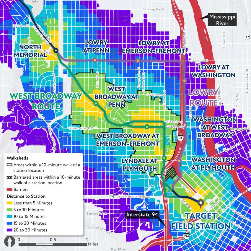
Welcome to the - Metropolitan Council
SUMMARY OF FEEDBACK
Below are the common themes that emerged from feedback received during the Draft Report comment period
(December 2021 – January 2022). Based on comments received, project staff provided additional analysis and figures
in the Route Modification Report to support the route recommendation.

  General support                                                                       Minimize impacts
    or opposition                                                                       (to traffic, pedestrian
                                                                                        movements, businesses,
                                    22   %                         17   %
                                                                                        homeowners, environment)     October 9, 2021 Bike, Walk, Bus tour of Minneapolis route options and station study areas

                                                                                              Other investments

                                                    %                           14 %          needed instead
                                                                                              of/in addition to
                                                                                              this project

                                                                                                                     Community meeting in Robbinsdale

                               29   %
  Serves community                                                     11   %
    destinations and
                                                                                              Efficient, well-
zero-car households
                                                           7   %                              connected transit

                                                                        More info needed

                                                                                                                     Talk Out Lao’d Facebook live event hosted by Lao Center of MN on May 26, 2021
Welcome to the - Metropolitan Council
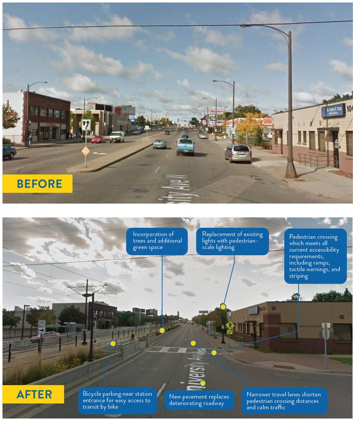
ROUTES FOR CONSIDERATION
Since March 2021, the project team has been evaluating and collecting public feedback on two
routes in Minneapolis: one along West Broadway (shown in green) and one along Lowry Avenue
(shown in purple) to connect to the cities of Robbinsdale and Crystal along County Road 81 and
then into Brooklyn Park. The routes evaluated represent the best options to extend the METRO Blue
Line Extension based on community input, technical considerations and past project work.
Welcome to the - Metropolitan Council
HOW ROUTE OPTIONS WERE EVALUATED
Project Principles and Goals
The route evaluation principles and goals were updated through community engagement. Project goals express overall project priorities, while
evaluation criteria provide specific, measurable ways to assess how well route options meet and inform these goals.

                             ROUTE                                                                 ENGAGEMENT
                           PRINCIPLES                                                               PRINCIPLES
                   • Meet Federal Transit
                     Administration (FTA) New                   Project                      • Meaningful engagement
                                                                                               of stakeholders
                     Starts criteria                           Principles                    • Engage, inform, and consult
                   • Maintain existing alignment                                               diverse communities to
                     (route) as much as possible                                               co-create project solutions
                   • Mitigate negative impacts                                                 that reduce disparities

                      PROJECT GOALS
                      1. Improve transit access and connections to         4. Support communities’ development goals.
                         jobs and regional destinations.
                                                                           5. Promote healthy communities and sound
                      2. Improve frequency and reliability of transit         environmental practices including efforts
                         service to communities in the corridor.              to address climate change.
                      3. Provide transit improvements that                 6. Advance local and regional equity and
                         maximize transit benefits, while being cost          work towards reducing regional
                         competitive and economically viable.                 racial disparities.
Welcome to the - Metropolitan Council
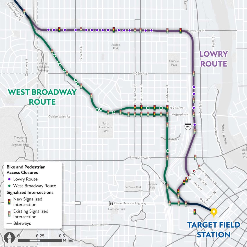
SUMMARY OF THE ROUTE EVALUATION
Each route has been evaluated based     All the routes have received an overall assessment of “good” in their ability to serve the community. In
on its ability to meet project goals.   some cases, these routes achieve an excellent rating based on unique features and the potential to deliver
                                        exemplary positive benefits. None of the routes have been assessed as “poor,” which would mean they did
                                        not meet the project goals.
         EXCELLENT
                                         ASSESSMENT OF ROUTE OPTIONS TO DEFINED GOALS
        Unique and/or high
        potential to provide                                                                            BOTTINEAU BOULEVARD       BOTTINEAU
                                                                                                                                                               WEST
                                                                                                           (COUNTY ROAD 81)       BOULEVARD        LOWRY
     exemplary positive benefits         PROJECT GOAL                                                     IN BROOKLYN PARK    (COUNTY ROAD 81)     ROUTE
                                                                                                                                                             BROADWAY
                                                                                                                                                               ROUTE
                                                                                                             AND CRYSTAL       IN ROBBINSDALE

                                               Goal 1: Improve transit access and connections to jobs
             GOOD                              and regional destinations
                                                                                                            EXCELLENT           EXCELLENT        EXCELLENT   EXCELLENT

               Meets                           Goal 2: Improve frequency and reliability of transit         EXCELLENT           EXCELLENT          GOOD        GOOD
            project goal                       service to communities in the corridor

                                               Goal 3: Provide transit improvements that maximize
                                               transit benefits, while being cost competitive and             GOOD                 GOOD            GOOD        GOOD
                                               economically viable
             POOR
                                                                                                              GOOD                 GOOD            GOOD      EXCELLENT
           Does not meet                       Goal 4: Support communities’ development goals
            project goal
                                               Goal 5: Promote healthy communities and sound
                                               environmental practices including efforts to address           GOOD                 GOOD            GOOD        GOOD
                                               climate change

                                               Goal 6: Advance local and regional equity                      GOOD                 GOOD            GOOD      EXCELLENT
                                               and work towards reducing regional racial disparities
Welcome to the - Metropolitan Council
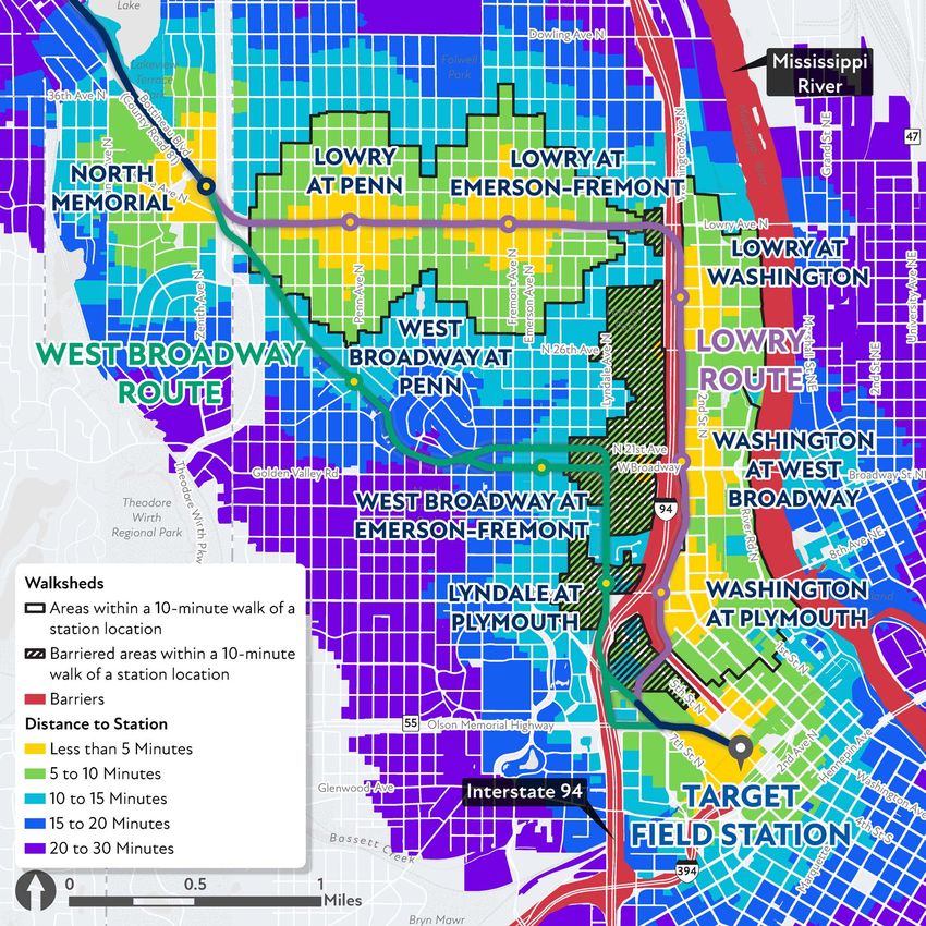
WALKSHEDS AND BARRIERS TO STATIONS
z   A significant portion of         10-Minute Route Walksheds and Barriers                                                                                     10-Minute Route Walksheds and Barriers
    the community would be           (Lowry Route)                                                                                                              (West Broadway Route)
    barriered from accessing
    stations along Washington
    Avenue on the Lowry route
    due to limited pedestrian
    crossings across I-94.
z   Only a small portion of
    the Lyndale at Plymouth
    walkshed is barriered along
    the West Broadway route.
z   Although the Lowry route
    serves a higher total
    population through its five
    stations, when accounting
    for barriered populations, the
    West Broadway route serves
    a higher percentage of low-
    income populations, residents
    of color, and zero vehicle
    households through three
    stations on a shorter route.

                                     Data Source: Urban Footprint
                                     Urban Footprint is an analysis software that generates travel time in minutes walking from a parcel to the nearest point of interest based on the shortest distance within the existing pedestrian network.
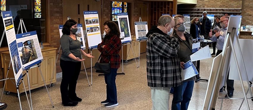
Welcome to the - Metropolitan Council
UNDEVELOPED PARCELS
z   Based on experience with both the Blue Line         Undeveloped Parcels (West Broadway and Lowry Routes)
    and the Green Line in the Twin Cities, it is
    anticipated that public and private investment
    would be made during design, construction,
    and after the BLRT is open.
z   Through the programs and policies that come
    out of the Anti-Displacement Workgroup,
    the intent would be to focus the investments
    on housing and business development and
    redevelopment that benefits the community.
z   One indication of redevelopment potential is
    the presence of undeveloped parcels in vicinity
    of station areas. This map shows undeveloped
    parcels within a 10-minute walking distance of
    proposed station areas.
z   There are more undeveloped properties along
    the West Broadway route, which accounts for
    the higher acreage of vacant land.

                                                        Data Source: Metropolitan Council - 2020 Land Use
                                                        *Undeveloped: Land not currently used for any defined purpose that may or may not contain buildings or other structures or has no discernable
                                                        use based upon the aerial photos or available data. Undeveloped may include non-protected wetlands or lands currently under development.
Welcome to the - Metropolitan Council
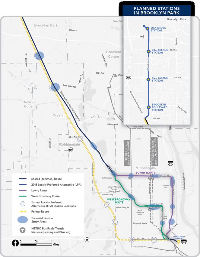
DESTINATIONS AND COMMUNITY-IDENTIFIED IMPORTANT PLACES
This map shows existing destinations within a half mile from the              Destinations and Community-Identified Important Places
proposed station areas in Minneapolis as well as destinations that            (West Broadway and Lowry Routes)
were identified as important places through community input.

Lowry Route:
z   The Washington Avenue section of the Lowry route and its proposed
    stations serve a limited type and number of existing destinations.
z   While the south end of Upper Harbor Terminal is within a 15-minute
    walk from the Washington at Lowry station area, the proposed land
    uses within this area are mostly manufacturing or industrial.
z   The Lowry Avenue section would serve some community
    destinations, including the North Regional Library.

West Broadway Route:
z   The West Broadway route and proposed stations would serve the
    existing vibrant cultural and economic corridor with connections to
    regional destinations and services (i.e., Capri Theater, Masjid An-Nur,
    Shiloh Temple)
z   Minneapolis Public Schools district offices and the West Broadway
    business district contribute to making West Broadway an important
    Job and Activity Center.

                                                                              Data Source: Hennepin County, City of Minneapolis, Metropolitan Council, and Community Input
Welcome to the - Metropolitan Council
PEDESTRIAN ACCESS CLOSURES
z   Based on feedback we heard from the               Pedestrian Access Closures (West Broadway and Lowry Routes)
    community, how light rail would impact
    pedestrian access across West Broadway
    or Lowry Avenue was an important issue
    to evaluate.
z   There are more opportunities for pedestrians to
    cross at the existing and proposed signalized
    intersections along the West Broadway route.
z   The project team will evaluate where pedestrian
    crossings need to be added as part of the next
    phase of the project.

                                                      *Closures are the permanent removals of pedestrian access at an intersection because of light rail tracks preventing crossings where crossing is currently permitted.
                                                      *Bikeways include designated bike trails, shared use trails, and on-street bike lanes.
                                                      Data source: City of Minneapolis
ROUTE RECOMMENDATION
The route recommendation is to extend the existing Blue Line from Target Field station along West
Broadway Avenue in Minneapolis to County Road 81 in Crystal and Robbinsdale, and along West
Broadway Avenue in Brooklyn Park.

                                                          OAK
                                               !!
                                                          GROVE
                                                                                                                           !!             Planned LRT Stations
This route will:                                                              610
                                                                                                                                          Station Study Areas
z   Connect people to                                                        93RD
                                                !                                                                                         METRO Blue Line Extension
    new opportunities                                !                       AVENUE

                                                         West Broadway Ave
    and destinations.
                                                                                                                        [
                                                                                              B ROOKL YN                                   0                                       1                             2
                                                                                                 PARK                                                                                                                M i l es
z   Link people more                                                         85TH
    efficiently to educational                  !!                           AVENUE

    and employment
    opportunities, reduce
                                 Bo unty
                                   (Co
                                    tti

    transit commute times, and
                                       ne

                                                                       BROOKLYN
                                                !!
                                         au B

                                                                       BOULEVARD
    increase access to goods
                                            Roa
                                             lvd )

                                                                   73rd Ave
                                               d8

    and services in an area
                                                 1

    where building community
    wealth is a priority.
                                                                                              694
z   Improve public health
                                           63RD
    and reduce pollution by              AVENUE                                                                     B ROOKL YN
    connecting people to                                                                                              CEN TER
    quality health care and
    providing clean active                           BASS LAKE
    transportation options.                              ROAD                                    Twin
                                                                                                 Lake
                                                                                                            100
z   Make a generational and
    unprecedented transit                                                      CRYSTAL
    investment in a corridor     N EW H OP E
    that has experienced a                                                                        ROB B I N SD AL E
                                                                                                                                                                                                      M I N N EAP OL I S
    history of systemic racism                                                       DOWNTOWN
                                                                                    ROBBINSDALE                                                                            94
    and high percentage of
                                                                                                                                                                                       M iss

                                                                                                        Crystal
                                                                                                         Lake
                                                                                                                                                                                         issip

    zero car households.
                                                                                                                            Penn Ave N

                                                                                                                                                 Fremont Ave N

                                                                                                                                                                 Lyndale Ave N

                                                                                                                                                                                              pi Riv
                                                                                                                                                                                                    er

                                                                                                 NORTH
                                                                                               MEMORIAL                Lowry Ave N
                                                                                                                                                                                        Washington Ave N
                                                                                                                       W
                                                                                                                        es

                                                                               GOL D EN
                                                                                                                          tB

                                                                                                                                                EMERSON -
                                                                                                                            ro

                                                                               VAL L EY
                                                                                                                               ad

                                                                                                               PENN                             FREMONT
                                                                                                                                  w      ay

                                                                                                             AVENUE                              AVENUE
                                                                                                                                            A
                                                                                                                                           ve

                                                                                                                  Golden Valley Rd

                                                                                                                                   Plymouth Ave N                                 PLYMOUTH
                                                                                                                                                                                  AVENUE

                                                                                          Olson Memorial Highway
                                                                                                                                            55
                                                                                                           Wirth
                                                                                                           Lake
                                                                                                                                                                                 TARGET FIELD
                                                                                                                                                                                   STATION
ANTI-DISPLACEMENT

  What we’ve heard
  From our engagement efforts, the greatest concern we heard is displacement impacts associated with the project.

✓ Our Commitments to the Community
    Metropolitan Council, Hennepin County, and cities along the corridor are committed to:
    z Implementing a comprehensive and innovative set of strategies to prevent multiple      Anti-Displacement Work Group
      forms of displacement
                                                                                             Work group consist of approximately 21 members:
    z Maximizing community benefits

    z Centering community voices                                                               z   6 government representatives
    z Building on, supporting, and protecting existing community assets                        z   6 community members affiliated with
    z Providing more opportunities for equitable housing, employment, business                     organizations businesses
      development, cultural experiences, and other activities of daily life
                                                                                               z   6 non-affiliated community members

✓ Our Actions                                                                                  z   3 philanthropic organization representatives
    z In March 2022, the Center for Urban and Regional Affairs (CURA) brought together a
      diverse Anti-Displacement Workgroup with seats for agency and community partners
      to begin developing Anti-Displacement initiatives.
    z The Anti-Displacement Workgroup will center its work around four day-long workshops

      between May 2022 and February 2023 on the following topics: lessons from the
      existing Blue and Green lines (including Blue Line Extension planning), housing and
      cultural displacement, business displacement, and finalizing recommendations.
    z CURA will provide recommendations that address potential displacement of residents

      and commercial businesses that may occur during planning, construction and after
      the line is completed, as well as provide a report and new research on the topic.

For more information about this work, including meetings and other resources, visit: mybluelineext.org/anti-displacement.
NEXT STEPS
                    Environmental Review
                     z The new route requires additional environmental documentation. New analyses will be
                       conducted to understand the potential social, economic, and environmental impacts that may
                       occur because of the design, construction, and operation of light rail.
                     z This process will determine how to avoid or reduce those impacts. If impacts cannot be

     PEDESTRIAN SAFETY IMPROVEMENTS LOOK L
                       avoided, then mitigation will be considered.
     PEDESTRIAN        SAFETY
       Station Area Planning  IMPROVEMENTS LOOK L
          z The area within a half-mile radius (or a ten-minute walk) of planned light rail transit stations
   These images      show safety improvements using the METRO Green Line on University
   These
   Avenueimages
           inis St.  show
                commonly
                    Paul   safety
                         asreferredimprovements
                                    to as the “stationusing
                             an example.               area.”the METRO
                                                              Typically, thisGreen  Line
                                                                              is where    on University
                                                                                       investments in transit
   Avenue ininfrastructure
                St. Paul asare
                             anexpected
                                 example.to generate the greatest community opportunities and impacts.
             Station area planning typically happens once engineering and design are underway and
                     z
zed intersection on University                             Unsignalized intersection on
 at Fairview could
             Avenueinclude walking,  biking, and  rolling connections
                                                           University  between
                                                                      Avenue at   stations
                                                                                 Oxford    and
                                                                                        Street station area
zed intersection on University                             Unsignalized intersection on
 at Fairview neighborhoods,
             Avenue            landscaping, lighting and other  infrastructure
                                                           University Avenue at improvements.
                                                                                 Oxford Street

                    Engineering and Design
                    The following are key engineering and design next steps:
                     z   Light Rail Design and Station
                         Locations: The final locations
                         of the light rail tracks and station
                         locations will be determined through
                         engineering, community engagement,
                         coordination with cities and
                         environmental study.
                     z Pedestrian                     access:        Safe and
                               Leading pedestrian intervals to                                                          Active warning           Incorporation of         Replacement of existing             Pedestrian crossings
                                                                  Pedestrian  crossing  signal                          devices                  additional green         lights with pedestrian-             which meets all
                               give pedestrians a head   start
                                                                                                                                                 space                    scale lighting of existing
                                                                                                                                                                          Replacement                         current  accessibility
                         efficient         pedestrian            connections
                               crossing
                               Leading  the intersection
                                        pedestrian  intervals to                                                        Active warning           Incorporation of                                             Pedestrian   crossings
ofof                                                              Pedestrian  crossing  signal                                                                            lights with pedestrian-             requirements,
                               give pedestrians  a head start                                                           devices                  additional green                                             which meets all
 en  space
 n space
                                                                                                                                                 space                    scale lighting                      including  ramps,
                                                                                                                                                                                                              current accessibility
                               crossing the intersection
ofof
 en  space
 n space                 between stations and station area                                                                                                                                                    tactile
                                                                                                                                                                                                              striping
                                                                                                                                                                                                                      warnings, and
                                                                                                                                                                                                              requirements,
                                                                                                                                                                                                              including ramps,

                         neighborhoods are critical in station
                                                                                                                                                                                                              tactile warnings, and
                                                                                                                                                                                                              striping

                         area planning, and a key criterion to
                         achieve federal funding. Pedestrian
                         facilities support connections to nearby
                         destinations
           Narrower travel lanes shorten
           pedestrian crossing distances             and provide access
           and calm traffic
           Narrower
                         for distances
                                people of all ages and abilities
                    travel lanes shorten
           pedestrian crossing
           and calm traffic
                         to   light      rail.
                      New pavement replaces
                                                  This        part of    design
                                                                     requirements,
                                                                                           and
                                                                     Pedestrian crossings which
                                                                     meet   all current accessibility
                                                                                      including ramps,
                                                                                                                             Bicycle parking near
                                                                                                                             station entrance   for easy      New pavement replaces         Narrower travel lanes shorten
                                                                                                                                                                                            pedestrian crossing distances
                         engineering                will     take  place          between
                                                                     Pedestrian crossings which                                                               deteriorating roadway
                      deteriorating roadway                          tactile warnings,   and push butons                     access
                                                                     meet all   current accessibility                        Bicycle to transitnear
                                                                                                                                      parking   by bike                                     and  calm traffic
                                                                                                                                                                                            Narrower  travel lanes shorten
                      New pavement replaces                          requirements, including ramps,                          station entrance for easy        New  pavement   replaces
                                                                                                                                                                                            pedestrian crossing distances
                         summer 2022 and winter 2024.
                      deteriorating roadway                          tactile warnings, and push butons                                                        deteriorating roadway
                                                                                                             Example of pedestrian and station area improvements along the METRO Green Line
                                                                                                                             access to transit by bike                                      and calm traffic

                     z Bicycle access: Safe and efficient bicycle connections between stations and station area

NE EXTENSION
                         neighborhoods                      help   expand             access           to a broader  area.   Bicycle           facilities         includes             both        designated
NE EXTENSION
                         infrastructure                improvements                  and       stations     features such    as     bicycle            parking.           This       part       of   design             and
                         engineering will take place between summer 2022 and winter 2024.
                     z Parking and Park and Rides: At this time the following locations are being considered for

                         some form of park and ride: Oak Grove Parkway Station, 63rd Avenue Station, Bass Lake
                         Road Station, and the Downtown Robbinsdale Station. Where current on-street parking is
                         impacted by the project, further study will be completed as part of the environmental phase to
                         determine what options may be needed to address lost parking.
WHAT DO PEDESTRIAN SAFETY IMPROVEMENTS LOOK LIKE?
                        These images show safety improvements using the METRO Green Line on University
                        Avenue in St. Paul as an example.

         Signalized intersection on University                    Unsignalized intersection on
         Avenue at Fairview Avenue                                University Avenue at Oxford Street

                                                                           Active warning
                                                                           devices

         Incorporation of
         additional green space

  METRO BLUE LINE EXTENSION
COMMUNITY BENEFITS
ENVIRONMENTAL AND COMMUNITY BENEFITS
z   Light rail offers a more environmentally friendly transportation option with electric-powered trains rather than
    single-occupancy, gas-dependent vehicles, which reduces pollution and the community’s carbon footprint
z   Land vacated for light rail can be used to increase green space and community-supported redevelopment
z   Provides an affordable transportation option

INFRASTRUCTURE IMPROVEMENTS
z   Roads are rebuilt from curb-to-curb. This will allow for other community infrastructure improvements such as:
     »   Modernized traffic design to improve the flow of traffic and safety
     »   Provides an opportunity for utility updates to happen concurrently with light rail construction (electrical, fiber
         optics, etc.)
     »   Stormwater and sewer updates to reduce flooding and manage water better

STREETSCAPE AND LANDSCAPE IMPROVEMENTS:
z   Lighting:
     »   Pedestrian scale lighting to create a more comfortable environment
     »   Provides safety and an additional buffer between transportation uses

z   Street Furniture and Bicycle Parking:
     »   Amenities for users along the corridor that are functional (bicycle parking, trash/recycling)
     »   Contribute to a more comfortable overall experience

z   Landscape/Greening:
     »   Provides environmental benefits with increased area for stormwater infiltration, introducing potential pollinator
         species, diversifying and increasing the amount of green in an urban environment
     »   Enhances the pedestrian experience and lowers the scale of a wide road

z   Special Pavement:
    »    Opportunity for community expression and function (i.e. could include colored concrete, pavers, different
         treatments to concrete to differentiate it)

             METRO BLUE LINE EXTENSION
SAFETY AND SECURITY
          Safety and security are key considerations factored into the planning and design of light rail well before the line is built or in operation.
          We plan and design the light rail platforms and station areas to be safe and secure with elements such as:

By planning and designing platforms                                                                                                 Appropriate lighting in the
and stations where people feel safe and                                                           1                             1
                                                                                                                                    station area and on the trains
comfortable, we create spaces where people
want to be. This puts more “eyes on the
                                                2                                                                               2   Real-time information
street” and deters illicit activities because
they are more likely to be observed.
                                                                                                                                3   Security cameras
                                                     3

                                                                                                                                4   Open-air and/or transparent
                                                                                                                                    shelters and waiting facilities.
                                                                                                            4
                                                                                                                                5   Consistent wayfinding and
                                                                                                                                    signage
                                                                                         5
                                                                                                                                6   A human-scale feel, which
                                                                                                                                    means facilities are designed to
                                                                                                                                    be comfortable to riders of all
                                                                                                 10                                 abilities.
                                                                                             6
                                                                                                                                7   Clear sight lines which allow
                                                                                                                                    train operators and riders to see
                                                                                                                                    each other.
                                                                                             7
                                                                                                                                8   Visibility from nearby roadways
                                                                                                                                    so riders feel safe and drivers
                8                                                                                                                   are aware of transit stops.
                                                                                             9
                                                                                                                                9   Intuitive circulation, which allows
                                                                                                                                    riders to safely access the trains.

                                                                                                                               10   Emergency telephones

             METRO BLUE LINE LRT EXTENSION
SCHEDULE
                                               COMMUNITY ENGAGEMENT
       We’re here

    1 YEAR              1.5 – 2 YEARS                  1.5 – 2 YEARS                       3 – 4 YEARS

  Identify          Environmental review             Develop construction    Construction            GOAL: Line
  community-        Document benefits and            ready design plans      and full funding        opens in 2028
  supported         impacts of the project           and preparing the       grant agreement
  route             Municipal consent                community for           Federal funding
                    Seek city support of the         construction
                    LRT design                       Station area planning
                    Begin engineering
                    Identify location of stations,
                    LRT, pedestrian and bicycle
                    access to stations
                    Station area planning

LRT projects are complex and unforeseen challenges arise. Schedules and timelines are subject to change.

Blue Line Extension Community Supported Route:
• Best meets the project Principles and Goals
• Grounded in community feedback through collaboration with stakeholders
• Supported by project corridor communities and decision-makers
STAY CONNECTED!

Visit BlueLineExt.org for more information to sign-up for the project newsletter, and
  share your comments, questions and concerns on our interactive feedback map.

       For project questions or to invite us to an event, contact:

       Brooklyn Park/Minneapolis:
       Pa Nhue Vue – PaNhue.Vue@metrotransit.org

       Robbinsdale/Crystal:
       Kjerstin Yager – Kjerstin.Yager@metrotransit.org

       Share your Blue Line Extension story at: mybluelineext.org

            @BlueLineExt		      @Blue_Line_Extension   @METROBlueLineExtension

    METRO BLUE LINE EXTENSION
You can also read