WATERFORD OAKS BASELINE PARK ANALYSIS - UPDATED: 3/22/2017 5:28:33 PM - Oakland ...
←
→
Page content transcription
If your browser does not render page correctly, please read the page content below
WATERFORD OAKS BASELINE PARK ANALYSIS

UPDATED: 3/22/2017 5:28:33 PM

BASELINE PARK ANALYSIS
WATERFORD OAKS COUNTY PARK                                                                                                                                      Page 2 of 51

CONTENTS
Park Location .................................................................................................................................................................4
Community Context .......................................................................................................................................................4
   Oakland County .........................................................................................................................................................5
   Waterford Township ..................................................................................................................................................5
   Drive-Time Service Area – Day Use............................................................................................................................5
   Drive-Time Service Area – Waterpark .....................................................................................................................10
Site Analysis .................................................................................................................................................................14
   Parcel Analysis .........................................................................................................................................................14
   Physical Characteristics............................................................................................................................................16
   Regional Context......................................................................................................................................................17
   Land Use ..................................................................................................................................................................17
Park History .................................................................................................................................................................18
   Early History.............................................................................................................................................................18
   Park History .............................................................................................................................................................20
Park Master Plans ........................................................................................................................................................22
   1972: Waterford Oaks Park Development Plan .......................................................................................................22
   1997: Waterford Oaks Master Plan Renovation ......................................................................................................24
   2012 Park Vision and Facility Concepts ...................................................................................................................26
   2015 Design Competition ........................................................................................................................................28
   2016: Waterford Oaks Preliminary Master Plan – Russell Design ...........................................................................29
Natural Resources........................................................................................................................................................33
Park Infrastructure and Assets ....................................................................................................................................36
Park Maps ....................................................................................................................................................................41
References ...................................................................................................................................................................49
Notes ...........................................................................................................................................................................50

UPDATED: 3/22/2017 5:28:33 PM
BASELINE PARK ANALYSIS
WATERFORD OAKS COUNTY PARK                                                                                                                           Page 3 of 51

TABLES
Table 1: Population Trends - 9-minute drive-time of Waterford Oaks..........................................................................7
Table 2: Race and Ethnicity – 9-minute drive-time of Waterford Oaks .........................................................................7
Table 3: Market Potential – 9-minute drive-time of Waterford Oaks ...........................................................................8
Table 4: Population Trends - 18-minute drive-time of Waterford Oaks ......................................................................11
Table 5: Race and Ethnicity – 18-minute drive-time of Waterford Oaks .....................................................................11
Table 6: Market Potential – 18-minute drive-time of Waterford Oaks .......................................................................12
Table 7: Parcels comprising Waterford Oaks...............................................................................................................14
Table 8: Deleted parcels within consolidated parcel #13-13-300-201 ........................................................................14
Table 9: Implementation status of 1972 Master Plan concepts ..................................................................................23
Table 10: Implementation status of 1997 Master Plan concepts ................................................................................25
Table 11: Implementation Status of 2012 Park Vision and Facility Concepts..............................................................26
Table 12: Natural Features at Waterford Oaks............................................................................................................33

FIGURES
Figure A: Waterford Oaks Drive-Time Map ...................................................................................................................6
Figure B: Population by Age – 9-minute drive-time of Waterford Oaks........................................................................7
Figure C: Waterpark Drive-Time Map ..........................................................................................................................10
Figure D: Population by Age – 18-minute drive-time of Waterford Oaks ...................................................................11
Figure E: 1823 Survey of Waterford Township, Sections 13 and 24 (BLM) .................................................................18
Figure F: 1997 Master Plan Renovation Concept by James C. Scott & Associates ......................................................24
Figure G: Russell Design preliminary master plan for Waterford Oaks .......................................................................30
Figure H: Waterford Oaks Natural Features Map ........................................................................................................35
Figure I: Waterford Oaks Trail and Facility Map ..........................................................................................................42
Figure J: Park map showing locations of selected planning units................................................................................43
Figure K: Farmers Market ............................................................................................................................................44
Figure L: Waterford Sections 13 and 24 Historic Plat Maps ........................................................................................45

UPDATED: 3/22/2017 5:28:33 PM
BASELINE PARK ANALYSIS
WATERFORD OAKS COUNTY PARK Page 4 of 51
Park Location
Waterford Oaks County Park is a 199-acre park located in
i
the center of Oakland County in Waterford Township .
Park Contact Information
1702 Scott Lake Road (Main Park Entrance)
2800 Watkins Lake Road (Activity Center and
Administrative Complex)
2350 Pontiac Lake Road (Farmers Market)
248-858-0918 (Waterpark)
248-858-0916 (Activity Center)
248-858-5495 (Farmers Market)
www.oakgov.com/parks/
Township and Range
T3N R9E, Sections 13 (west ½ and southeast ¼) and 24
(northwest ¼)
Community Context
The characteristics of Waterford Oaks are
unique and reflect the character of the local
communities. It is important to understand the
park within the context of its communities –
Michigan, Oakland County, and Waterford
Township – for multiple reasons:
To convey a ‘sense of place’ that is
harmonious and complementary to
the local environment
To ensure that Oakland County Parks
is not duplicating services provided
by local recreational authorities or by
the private, non-profit, or larger
regional/state providers
To collaborate with units of
governments and organizations
related to the Oakland County Parks
mission to manage open space and
natural areas and provide
recreational facilities and programs
on an inter-community, county and/or multi-county basis
i
See Planning Map Set, page 3 – Location Map
UPDATED: 3/22/2017 5:28:33 PM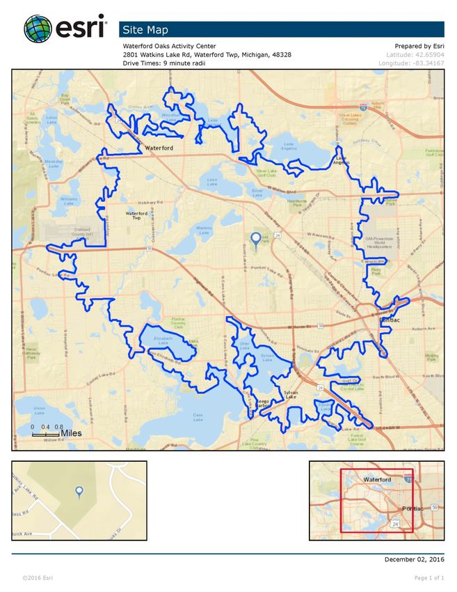
BASELINE PARK ANALYSIS
WATERFORD OAKS COUNTY PARK Page 5 of 51
To develop facilities and programs that contribute to the implementation of local and county plans
To ensure compliance with local and county regulations
Oakland County
Oakland County is located in southeast Michigan, approximately 20 miles northwest of Detroit, and covers 907
square miles (SEMCOG, 2015). The estimated population in 2016 was 1,234,680 and the median household income
was $69,354 (US Census Bureau, 12/2/2016). In 2010-2014, an estimated 10% of households had income below
the poverty level (ACS, 12/2/2016).
According to Advantage Oakland, Oakland County employs nearly 690,000 workers with more than 260,000
commuting from outside the county. The top three employment sectors are Professional and Business Services
(26%), Trade, Transportation and Utilities (18%), and Private Education and Health Services (16%). The county is
home to nearly 1,000 firms from 39 foreign countries (EDCA).
Within the county, there are 30 cities, 21 townships, and 11 incorporated villages, in urban, suburban, and rural
landscapes. The county is home to the headwaters of five major rivers, the Clinton, Flint, Huron, Rouge, and
Shiawassee Rivers, all of which are important to the long-term health of the Great Lakes Ecosystem. Many diverse
ecosystems are located in the county due to the area’s complex topography and geological history and are an
important element in the character of the county (OCPRC, 2013).
Oakland County Parks and Recreation
Oakland County Parks and Recreation (OCPR) provides parks and recreation services within the geographic
boundaries of Oakland County, but are also open to visitors to the county. Since 1966, OCPR has expanded and
diversified the park system from four parks to thirteen, now totaling over 6,700 acres. Key attractions include
managed natural areas, nature centers, waterparks, golf courses, conference centers, campgrounds, fairgrounds
and over 65 miles of park trails. OCPR also offers a variety of entertaining and educational recreation programs and
services for various ages and abilities (OCPRC, 2013).
Waterford Township
Waterford Oaks County Park is located in Waterford Township in the center of Oakland County. The township
covers 35.3 square miles (SEMCOG, 2015). The estimated population in 2016 was 72,232 and the median
household income was $55,984 (US Census Bureau, 12/2/2016). In 2010-2014, an estimated 11.6% of households
had income below the poverty level (ACS, 12/2/2016).
i
Description from Township Website : Waterford Township is a great place to live, work and visit. Established in
1834, Waterford is centrally located in Oakland County. It’s the fifth largest Township by population in Michigan. It
is a “Lakeland Paradise” with 34 lakes and has much to offer residents, businesses and visitors alike.
Drive-Time Service Area – Day Use
This purpose of this section is to outline the geographic area that draws the majority of visitors to a specific park or
facility (drive-time service area) and describe the demographic and socio-economic characteristics of the people
who live there.
i
http://waterfordmi.gov/462/Discover-Waterford
UPDATED: 3/22/2017 5:28:33 PM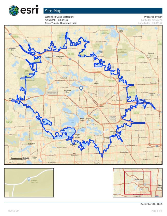
BASELINE PARK ANALYSIS
WATERFORD OAKS COUNTY PARK                                                                                   Page 6 of 51

The drive-time analysis is conducted using park visitor home zip codes that are collected at point-of-sale (OCPRC,
2015). The median drive-time – indicating that half of all visitors drive for a specific length of time or less – is used
to approximate the service area for each park and facility. At this time, zip code data is not available for users of
Waterford Oaks. For the purpose of this analysis, a 9-minute median drive-time was selected to align it with the
drive-times of two other parks in urbanized areas – Red Oaks and Glen Oaks.

Figure A: Waterford Oaks Drive-Time Map

UPDATED: 3/22/2017 5:28:33 PM

BASELINE PARK ANALYSIS
WATERFORD OAKS COUNTY PARK                                                                                       Page 7 of 51

Population and Income Trends i

Table 1: Population Trends - 9-minute drive-time of Waterford Oaks
    Summary                                     Census 2010                     2016                    2020
     Population                                         79,138                 80,035                  81,817
     Households                                         31,695                 32,232                  33,079
     Families                                           19,119                 19,128                  19,465
     Average Household Size                               2.42                    2.40                    2.40
     Owner Occupied Housing Units                       20,274                 20,197                  20,631
     Renter Occupied Housing Units                      11,421                 12,035                  12,447
     Median Age                                           37.4                    38.5                    39.0
    Trends: 2015 - 2020 Annual Rate                       Area                  State                National
     Population                                         0.44%                  0.23%                   0.84%
     Households                                         0.52%                  0.28%                   0.79%
     Families                                           0.35%                  0.16%                   0.72%
     Owner Households                                   0.43%                  0.27%                   0.73%
     Median Household Income                            2.63%                  2.26%                   1.89%

Figure B: Population by Age – 9-minute drive-time of Waterford Oaks

Table 2: Race and Ethnicity – 9-minute drive-time of Waterford Oaks
                                         Census 2010                                2015                               2020
    Race and Ethnicity                   Number        Percent            Number         Percent          Number          Percent
     White Alone                          57,840        73.1%              56,301          70.3%           55,575             67.9%
     Black Alone                          13,684        17.3%              15,019          18.8%           16,539             20.2%
     American Indian Alone                   432          0.5%                443          0.6%                  450          0.6%
     Asian Alone                           1,659          2.1%              2,041          2.6%             2,410             2.9%
     Pacific Islander Alone                    20         0.0%                 30          0.0%                  35           0.0%
     Some Other Race Alone                 2,887          3.6%              3,198          4.0%             3,475             4.2%
     Two or More Races                     2,615          3.3%              3,003          3.8%             3,333             4.1%

     Hispanic Origin (Any Race)            8,932        11.3%               9,992          12.5%           11,080             13.5%

i
 Population and income profiles are generated for the drive-time service area using Esri ArcGIS Business Analyst Online.
Demographic data is compiled by Esri from US Census Bureau data. Esri builds ArcGIS, which “connects people with maps, data,
and apps through geographic information systems (GIS). It is a location platform that’s accessible to anyone, anywhere,
anytime”. http://www.esri.com/about-esri#what-we-do
UPDATED: 3/22/2017 5:28:33 PM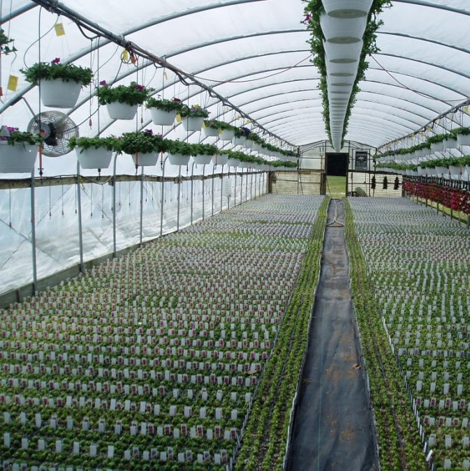
BASELINE PARK ANALYSIS
WATERFORD OAKS COUNTY PARK                                                                               Page 8 of 51

Market Potential Index – Recreation and Pet-Related Expenditures
ESRI's Market Potential Index (MPI) measures the relative likelihood of the adults or households in the specified
trade area to exhibit certain consumer behavior or purchasing patterns compared to the U.S. An MPI of 100
represents the U.S. average.

Table 3: Market Potential – 9-minute drive-time of Waterford Oaks
                                                                       Percent of
                              Product / Consumer Behavior              Population        MPI
                      Walking for Exercise in past 12 months               25.1%               94
                      Households owning 1 dog                                24.8%           101
                      Households owning 2 or more dogs                       15.7%             96
                      Fishing (Fresh Water) in past 12 months                12.7%           103
                      Overnight Camping Trip in past 12 months               11.4%             96
                      Jogging/Running in past 12 months                      10.9%             82
                      Bicycling (Road) in past 12 months                      8.7%             87
                      Golf in past 12 months                                  8.6%             95
                      Hiking in past 12 months                                7.9%             80
                      Canoeing Kayaking in past 12 months                     5.5%             98
                      Horseback Riding in past 12 months                      2.0%             82

Tapestry Segmentation i
Tapestry Segmentation classifies neighborhoods into 67 unique segments based not only on demographics but also
socioeconomic characteristics. It describes US neighborhoods in easy-to-visualize terms to help understand
residents’ lifestyle choices, what they buy, and how they spend their free time and help identify best customers,
optimal sites, and underserved markets.

The Esri Dominant Tapestry Map shows the tapestry segments within and surrounding the drive-time radius and
provides a list of the Tapestry segments with hyperlinks to detailed descriptions. See Planning Map Set, pages 21-
22 – Esri Dominant Tapestry Map.

The top five Tapestry segments within the drive-time radius are shown below. Each segment name is hyper-linked
to the detailed Esri profile. After the name, we show the percentage of households that are included in each
segment – within the drive-time radius and nationally. The Tapestry segment summary from the Esri profile is
included with each entry.

Rustbelt Traditions (5D)

Describes 21.8% of households within the drive-time radius; 2.2% of households in the U.S.

The backbone of older industrial cities in states surrounding the Great Lakes, Rustbelt Traditions residents are a mix
of married-couple families and singles living in older developments of single-family homes. While varied, the work
force is primarily white collar, with a higher concentration of skilled workers in manufacturing, retail trade, and
health care. Rustbelt Traditions represents a large market of stable, hard-working consumers with modest incomes
but above average net worth (Index 111). Family oriented, they value time spent at home. Most have lived, worked,
and played in the same area for years.

Hardscrabble Road (8G)

i
 http://www.esri.com/data/tapestry; See Planning Map Set, page 23 – Dominant Tapestry Map (Waterford Activity
Center)
UPDATED: 3/22/2017 5:28:33 PM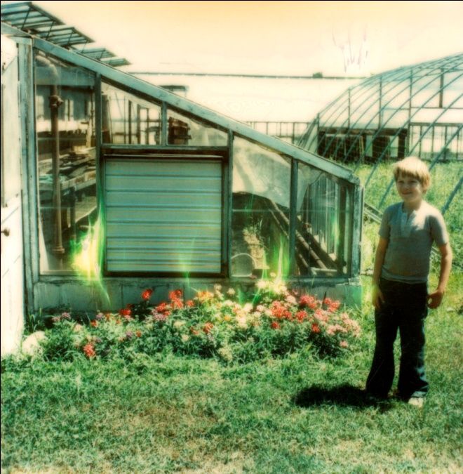
BASELINE PARK ANALYSIS
WATERFORD OAKS COUNTY PARK                                                                                Page 9 of 51

Describes 11.1% of households within the drive-time radius; 1.2% of households in the U.S.

Hardscrabble Road neighborhoods are in urbanized areas within central cities, with older housing, located chiefly in
the Midwest and South. This slightly smaller market is primarily a family market, married couples (with and without
children) and single parents. Younger, highly diverse (with higher proportions of black, multiracial, and Hispanic
populations), and less educated, they work mainly in service, manufacturing, and retail trade industries.
Unemployment is high (almost twice the US rate), and median household income is half the US median. Almost 1 in
3 households have income below the poverty level. Approximately 60% of householders are renters, living primarily
in single-family homes, with a higher proportion of dwellings in 2–4 unit buildings. This market is struggling to get
by.

Comfortable Empty Nesters (5A)

Describes 10.6% of households within the drive-time radius; 2.5% of households in the U.S.

Residents in this large, growing segment are older, with more than half of all householders aged 55 or older; many
still live in the suburbs where they grew up. Most are professionals working in government, health care, or
manufacturing. These Baby Boomers are earning a comfortable living and benefitting from years of prudent
investing and saving. Their net worth is well above average (Index 363). Many are enjoying the transition from child
rearing to retirement. They value their health and financial well-being.

Traditional Living (12B)

Describes 8.8% of households within the drive-time radius; 2.0% of households in the U.S.

Residents in this segment live primarily in low-density, settled neighborhoods in the Midwest. The households are a
mix of married-couple families and singles. Many families encompass two generations who have lived and worked
in the community; their children are likely to follow suit. The manufacturing, retail trade, and health care sectors
are the primary sources of employment for these residents. This is a younger market—beginning householders who
are juggling the responsibilities of living on their own or a new marriage, while retaining their youthful interests in
style and fun.

Set to Impress (11D)

Describes 7.0% of households within the drive-time radius; 1.4% of households in the U.S.

Set to Impress is depicted by medium to large multiunit apartments with lower than average rents. These
apartments are often nestled into neighborhoods with other businesses or single-family housing. Nearly one in
three residents is 20 to 34 years old, and over half of the homes are nonfamily households. Although many
residents live alone, they preserve close connections with their family. Income levels are low; many work in food
service while they are attending college. This group is always looking for a deal. They are very conscious of their
image and seek to bolster their status with the latest fashion. Set to Impress residents are tapped into popular
music and the local music scene.

UPDATED: 3/22/2017 5:28:33 PM
BASELINE PARK ANALYSIS
WATERFORD OAKS COUNTY PARK                                                                                Page 10 of 51

Drive-Time Service Area – Waterpark
This purpose of this section is to outline the geographic area that draws the majority of visitors to a specific park or
facility (drive-time service area) and describe the demographic and socio-economic characteristics of the people
who live there.

The drive-time analysis is conducted using park visitor home zip codes that are collected at point-of-sale (OCPRC,
2015). The median drive-time – indicating that half of all visitors drive for a specific length of time or less – is used
to approximate the service area for each park and facility. The median drive time for visitors to the Waterford Oaks
Waterpark was 18 minutes.

Figure C: Waterpark Drive-Time Map

UPDATED: 3/22/2017 5:28:33 PM
BASELINE PARK ANALYSIS
WATERFORD OAKS COUNTY PARK                                                                                   Page 11 of 51

Population and Income Trends i
Table 4: Population Trends - 18-minute drive-time of Waterford Oaks
         Summary                                       Census 2010                     2016                    2020
           Population                                        241,970                 245,580                251,701
           Households                                         95,599                  97,470                100,176
           Families                                           62,595                  63,055                 64,412
           Average Household Size                                2.49                      2.48                 2.47
           Owner Occupied Housing Units                       66,596                  67,016                 68,739
           Renter Occupied Housing Units                      29,003                  30,453                 31,437
           Median Age                                            38.7                      39.9                 40.7
         Trends: 2015 - 2020 Annual Rate                         Area                  State               National
           Population                                         0.49%                   0.23%                   0.84%
           Households                                         0.55%                   0.28%                   0.79%
           Families                                           0.43%                   0.16%                   0.72%
           Owner HHs                                          0.51%                   0.27%                   0.73%
           Median Household Income                            2.56%                   2.26%                   1.89%

Figure D: Population by Age – 18-minute drive-time of Waterford Oaks

Table 5: Race and Ethnicity – 18-minute drive-time of Waterford Oaks
                                           Census 2010                              2015                             2020
    Race and Ethnicity                     Number      Percent            Number        Percent           Number        Percent
     White Alone                          177,466        73.3%           174,022           70.9%          172,601           68.6%
     Black Alone                           42,061        17.4%             45,255          18.4%           49,160           19.5%
     American Indian Alone                    945        0.4%                 972           0.4%              993           0.4%
     Asian Alone                            8,324        3.4%              10,368           4.2%           12,415           4.9%
     Pacific Islander Alone                    50        0.0%                  68           0.0%                78          0.0%
     Some Other Race Alone                  6,268        2.6%               6,993           2.8%            7,632           3.0%
     Two or More Races                      6,857        2.8%               7,904           3.2%            8,822           3.5%

     Hispanic Origin (Any Race)            19,127        7.9%              21,527           8.8%           24,021           9.5%

i
 Population and income profiles are generated for the drive-time service area using Esri ArcGIS Business Analyst Online.
Demographic data is compiled by Esri from US Census Bureau data. Esri builds ArcGIS, which “connects people with maps, data,
and apps through geographic information systems (GIS). It is a location platform that’s accessible to anyone, anywhere,
anytime”. http://www.esri.com/about-esri#what-we-do
UPDATED: 3/22/2017 5:28:33 PM
BASELINE PARK ANALYSIS
WATERFORD OAKS COUNTY PARK Page 12 of 51
Market Potential Index – Recreation and Pet-Related Expenditures
ESRI's Market Potential Index (MPI) measures the relative likelihood of the adults or households in the specified
trade area to exhibit certain consumer behavior or purchasing patterns compared to the U.S. An MPI of 100
represents the U.S. average.
Table 6: Market Potential – 18-minute drive-time of Waterford Oaks
Percent of
Product / Consumer Behavior Population MPI
Walking for Exercise in past 12 months 27.8% 104
Households owning 1 dog 25.2% 103
Households owning 2 or more dogs 15.6% 96
Jogging/Running in past 12 months 12.8% 97
Fishing (Fresh Water) in past 12 months 12.3% 100
Overnight Camping Trip in past 12 months 11.9% 100
Bicycling (Road) in past 12 months 10.1% 102
Golf in past 12 months 9.9% 108
Hiking in past 12 months 9.8% 99
Canoeing Kayaking in past 12 months 6.0% 108
Horseback Riding in past 12 months 2.3% 92
Tapestry Segmentation i
Tapestry Segmentation classifies neighborhoods into 67 unique segments based not only on demographics but also
socioeconomic characteristics. It describes US neighborhoods in easy-to-visualize terms to help understand
residents’ lifestyle choices, what they buy, and how they spend their free time and help identify best customers,
optimal sites, and underserved markets.
The Esri Dominant Tapestry Map shows the tapestry segments within and surrounding the drive-time radius and
provides a list of the Tapestry segments with hyperlinks to detailed descriptions. See Planning Map Set, pages 21-
22 – Esri Dominant Tapestry Map.
The top five Tapestry segments within the drive-time radius are shown below. Each segment name is hyper-linked
to the detailed Esri profile. After the name, we show the percentage of households that are included in each
segment – within the drive-time radius and nationally. The Tapestry segment summary from the Esri profile is
included with each entry.
Rustbelt Traditions (5D)
Describes 12.7% of households within the drive-time radius; 2.2% of households in the U.S.
The backbone of older industrial cities in states surrounding the Great Lakes, Rustbelt Traditions residents are a mix
of married-couple families and singles living in older developments of single-family homes. While varied, the work
force is primarily white collar, with a higher concentration of skilled workers in manufacturing, retail trade, and
health care. Rustbelt Traditions represents a large market of stable, hard-working consumers with modest incomes
but above average net worth (Index 111). Family oriented, they value time spent at home. Most have lived, worked,
and played in the same area for years.
i
http://www.esri.com/data/tapestry; See Planning Map Set, page 23 – Dominant Tapestry Map (Waterford
Waterpark)
UPDATED: 3/22/2017 5:28:33 PMBASELINE PARK ANALYSIS WATERFORD OAKS COUNTY PARK Page 13 of 51 Comfortable Empty Nesters (5A) Describes 7.6% of households within the drive-time radius; 2.5% of households in the U.S. Residents in this large, growing segment are older, with more than half of all householders aged 55 or older; many still live in the suburbs where they grew up. Most are professionals working in government, health care, or manufacturing. These Baby Boomers are earning a comfortable living and benefitting from years of prudent investing and saving. Their net worth is well above average (Index 363). Many are enjoying the transition from child rearing to retirement. They value their health and financial well-being. Green Acres (6A) Describes 5.8% of households within the drive-time radius; 3.2% of households in the U.S. The Green Acres lifestyle features country living and self-reliance. They are avid do-it-yourselfers, maintaining and remodeling their homes, with all the necessary power tools to accomplish the jobs. Gardening, especially growing vegetables, is also a priority, again with the right tools, tillers, tractors, and riding mowers. Outdoor living also features a variety of sports: hunting and fishing, motorcycling, hiking and camping, and even golf. Self-described conservatives, residents of Green Acres remain pessimistic about the near future yet are heavily invested in it. Hardscrabble Road (8G) Describes 5.4% of households within the drive-time radius; 1.2% of households in the U.S. Hardscrabble Road neighborhoods are in urbanized areas within central cities, with older housing, located chiefly in the Midwest and South. This slightly smaller market is primarily a family market, married couples (with and without children) and single parents. Younger, highly diverse (with higher proportions of black, multiracial, and Hispanic populations), and less educated, they work mainly in service, manufacturing, and retail trade industries. Unemployment is high (almost twice the US rate), and median household income is half the US median. Almost 1 in 3 households have income below the poverty level. Approximately 60% of householders are renters, living primarily in single-family homes, with a higher proportion of dwellings in 2–4 unit buildings. This market is struggling to get by. Exurbanites (1E) Describes 4.9% of households within the drive-time radius; 1.9% of households in the U.S. Ten years later, Exurbanites residents are now approaching retirement but showing few signs of slowing down. They are active in their communities, generous in their donations, and seasoned travelers. They take advantage of their proximity to large metropolitan centers to support the arts, but prefer a more expansive home style in less crowded neighborhoods. They have cultivated a lifestyle that is both affluent and urbane. UPDATED: 3/22/2017 5:28:33 PM
BASELINE PARK ANALYSIS
WATERFORD OAKS COUNTY PARK Page 14 of 51
Site Analysis
Parcel Analysis
Waterford Oaks County Park consists of two parcels. The Oakland County Farmers Market is considered part of
Waterford Oaks and is located on a separate parcel owned by Oakland County – the portion managed by OCPR
equals 14 acres.
Table 7: Parcels comprising Waterford Oaks
Parcel ID Acres Deed/ Lease/ Easement / Agreement Liber and Page
13-13-300-201 182.98 See Table 8 for deleted parcels
2012-
Consolidated from
1967- Quit Claim Deed- Consumers Power Co. to OC--
17 previous 4995/532
10’ Easement
parcels (see Table
8)
13-24-426-001 (36 total- 2003- Warranty Deed (OC Board of Comm. to OC 2791/071
(Oakland County 14 acres Building Authority)
Farmers Market) managed
2003- Quit Claim Deed (Oakland Schools to OC) 29764/670
by OCPR)
2012- Covenant Deed (OC to OC Building Authority) 44759/567
Lease agreement
Table 8: Deleted parcels within consolidated parcel #13-13-300-201
Parcel ID Acres Deed/ Lease/ Easement / Agreement Liber and Page
13-13-152-008 22.25 2008- Pontiac Elks Temple Assoc. Deed 40771/188
(from-004,-006, - 6.14 2008-Toliver Quit Claim Deed 40764/450
002)
16.11 2008-Tolliver Warranty Deed 40771/186
13-13-300-006 5.82 1972-Wright Deed 06009/049
13-13-300-007 See table 9 below
13-13-300-010 87.06 OSA-80 6 parcels-- 87.06 acres
1968- Fields, Guzzo, Lavire OSA-80 (46) 5144/22
1973-Fields, Guzzo, Lavire OSA-80 (46) 6063/259
1968-Wright Deed OSA-80 (6.54/6.23) hard copy
1968-Leonard (Kelly) Deed OSA-80 (10/9.8) 5162/279
1968-Leonard (Kelly) Deed OSA-80 (1.58) 05262/026
13-13-300-195 5.20 2009-Ernst Deed 41367/813
13-13-300-196 8.9 1975-Ernst Deed 06518/722
(from -009) 1988-Detroit Edison Co R-O-W (underground) 10403/589
13-13-451-001 29 No deed found in records search
1988-Pontiac Creek Extension Drain R-O-W 10354/453
1988-Consumers Power Co 3’ Easement 10999/175
13-24-126-003 OSA-80—19.5 acres See table 9 below
UPDATED: 3/22/2017 5:28:33 PMBASELINE PARK ANALYSIS
WATERFORD OAKS COUNTY PARK Page 15 of 51
Parcel ID Acres Deed/ Lease/ Easement / Agreement Liber and Page
1988-Detroit Edison Co R-O-W (underground) 10403/589
13-24-126-004 0.65 1990-Meredith Deed 11606/868
13-24-126-006 3.95 1969-Shuler (Schweigart)- 2 parcels 05304/564
0.5 1971-Schweigart (assuming PIN) See table 9 below
1988-Detroit Edison Co R-O-W (underground) 10403/589
13-24-126-009 36.3 No deed found in records search
1992-Waterford Township Easement-water main 12499/158
13-24-126-012 0.82 2008-Kidwell Deed 40380/736
13-24-126-013 2.14 1975-Warren Deed 06511/820
(from -005) 1988-Detroit Edison Co R-O-W (underground) 10403/589
13-24-126-014 0.86 1990-Warren Deed 11324/261
(also from -005,
see -013 above)
13-24-126-015 0.48 1984-Swanson Warranty Deed 08758/836
(from -007) 1984-Swanson Quit Claim Deed 08758/839
2.14 total
13-24-126-016 0.69 1984- Fry Deed 08671/877
(also from -007,
see -015 above)
13-24-126-018 2.32 2009- E. Michigan District of Wesleyan Church 40941/141
(from -001 and -
011)
13-24-126-019 36.3 1973-18.3 acres OC to Children’s Village (assuming See table 9 below
(from-008,-009) PIN)
Table 9: Unconfirmed parcel ids and deeds potentially related to deleted parcels within consolidated parcel #13-13-300-201
Parcel ID Acres Deed/ Lease/ Easement / Agreement Liber and Page
13-13-300-007 3.23 1974-Leonard (Kelley) Deed 6266/683
13-18-308-007
13-13-300-010 21.66 1968- Magid Deed OSA-80 05141/403
24.08 1968- James QC Deed (corrects 5167/338) OSA-80 05188/465
13-13-451-001 29 No deed found in records search
13-24-126-003 19.5 1968-Evangelical Missionary Church Deed 05206/170
13-24-126-006 0.5 1971-Schweigart 05304/564
13-24-126-012 1.182 1975-Kidwell Deed
13-24-126-019 36.3 1973-18.3 acres OC to Children’s Village
(from-008,-009)
UPDATED: 3/22/2017 5:28:33 PMBASELINE PARK ANALYSIS
WATERFORD OAKS COUNTY PARK Page 16 of 51
Physical Characteristics
Geology i
1 2
The property lies within the Washtenaw Subsection Ecoregion and the Jackson Interlobate Sub-subsection . This
3 4
area is found between three glacial lobes and is characterized by ice‐contact topography and glacial deposits
(Albert D. , 1995). The park consists of rolling glacial topography with ground moraines and outwash plains.
Soils ii
Fourteen soil types are found on the property, ranging from very poorly‐drained mucky soils in the wetlands and
ponds, to well‐drained loamy soils in the uplands.
Topography iii
Elevation varies by 45 feet from approximately 945 feet to 990 feet above sea level. The ground surface within
much of the park slopes toward the Pontiac Creek Drain. The eastern portion of the park, which contains part of
the trail system and Lookout Lodge, contains a few areas of dramatic topography, with a few valleys and scenic
overlooks. The northern portion of the park, accessible by Alliance Drive, is mostly flat. A steep berm for the
adjoining railroad is present along the park’s northeastern boundary.
The rolling topography of portions of the park offers opportunities to promote many of the ‘adrenaline’ sports,
such as mountain biking, cross-country skiing, sledding, trail running and zip-lines. Unfortunately, the topography
can create a barrier to accessibility and dealing with the challenges of slope can increase construction costs. Also,
the orientation of slope can have a significant effect on the design and engineering needed to construct park
improvements.
Hydrography iv
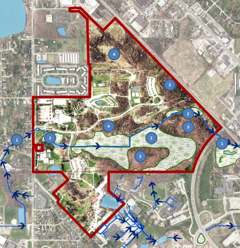
Waterford Oaks lies within the Clinton River Watershed and the Clinton Main Subwatershed. The main branch of
the Clinton River is located approximately 1.5 miles to the west at Waterford Township’s Drayton Plains Nature
Center. The Pontiac Creek originates at the park, where it has been converted into a County Drain, known as the
Pontiac Creek Extension or Mainland Drain. The drain runs easterly through the middle of the park. It is
channelized underneath Telegraph Road, and terminates at the County Service Center pond located north of the
railroad and east of Telegraph Road. Wetlands surround Pontiac Creek due to a high water table most of the year.
There are four ponds in the park‐‐ one pond north of the Activity Center, one south of the greenhouses, one in the
BMX track, and one north of the volleyball courts. Additional newly created ponds and swales around the
Administrative complex have been constructed for storm water treatment and collection.
Presettlement Plan Communities v
The pre-settlement habitat (circa 1816-1856) was Black Oak Barren in the north half, Mixed Conifer Swamp
through the middle and Mixed Oak Savanna in the south half (Comer & Albert, 1997).
i
See Planning Map Set, page 4 – Surface Geology
ii
See Planning Map Set, page 5 – Soils
iii
See Planning Map Set, page 6 – Ten Foot Contours
iv
See Planning Map Set, page 7 – Hydrography
v
See Planning Map Set, page 8 – Presettlement Vegetation
UPDATED: 3/22/2017 5:28:33 PMBASELINE PARK ANALYSIS
WATERFORD OAKS COUNTY PARK Page 17 of 51
Regional Context
Potential Natural Areas i
5
A portion of the wetland complex has been designated by the Michigan Natural Features Inventory (MNFI) as a
Priority 3 (lowest status) Natural Area.
Watershed ii
Waterford Oaks lies within the Clinton River Watershed and the Clinton Main Subwatershed.
Green Infrastructure iii
A majority of the park is included within the Oakland County Green Infrastructure Vision (OCPEDS, 2009) .
Land Use iv
Zoning
The park is zoned as Public Lands, PL. Note that nursery establishments on zoning lots five contiguous acres or
larger are permitted with special approval.
Current Land Use
Current land use is focused on recreation. See Parcel Analysis section for information about easements and rights-
of-way to which the property may be subject.
Surrounding Land Use
An active rail line, operated by Canadian National Railroad, forms the northeast boundary of the park with vacant
and industrial land and Dixie Highway beyond. Telegraph Road and the Oakland County Juvenile Corrections
6
Center (Children’s Village) form the eastern boundary. The Oakland County Public Works Building is located to the
south of the park. The western boundary of the park is formed by various roadways and properties: Watkins Lake
Road (with single-family residences on the opposite side); Waterford Oaks Community Church; Scott Lake Road
(with single-family residences on the opposite side); Colonial Village residential apartment complex; single-family
homes; a car wash; a self-storage business; Elk’s Lodge; and Alliance Drive. Industrial businesses are located north
of the park, along Alliance Drive.
Zoning districts within Waterford Township that adjoin Waterford Oaks include Neighborhood Business (C-1), High
Tech Office (HT-1), High Tech Industrial and Office (HT -2), Light Industrial (M-1), General Industrial (M-2), General
Office (O-2), Public Lands (PL), Single-Family Residential (R1-A, B, and C), and Multi-Family Residential (R-M2).
Past Land Use v
Prior to phased development of Waterford Oaks, much of the land was in agricultural use or consisted of woods,
wetlands and vacant land. A number of single family homes were located along the west boundary of the park, on
Scott Lake and Watkins Lake Roads. Three of those homes are still standing and owned by OCPR, which includes
the former Ernst family residence at 1580 Scott Lake Road (by the greenhouses). This home was originally
constructed in 1870, and its affiliated barn was constructed in 1880. There are currently two other single-family
residences owned and leased by OCPR, located along Watkins Lake Road.
i
See Planning Map Set, page 9 – MNFI Potential Natural Area
ii
See Planning Map Set, page 10 – Oakland County Subwatersheds
iii
See Planning Map Set, page 11 – Green Infrastructure
iv
See Planning Map Set, page 12 – 2015 Land Use
v
See Planning Map Set, pages 13-20 for views of the park from 1940 through 2015
UPDATED: 3/22/2017 5:28:33 PMBASELINE PARK ANALYSIS
WATERFORD OAKS COUNTY PARK Page 18 of 51
Park History
Early History
The central portion of Waterford Oaks occupies much
of the southwest quarter of Section 13 with smaller
areas occupying the northwest and southeast quarters.
Another portion lies in the northwest quarter of
Section 24.
7
The General Land Office (GLO) survey for Sections 13
and 24 of Township 3 North, Range 9 East in Michigan
Territory was filed at the Surveyors General Office in
Ohio on February 20, 1819. The land on the section line
between Sections 13 and 24 is described in the
surveyor’s notes as “barren timber oak” and “part
tamarack swamp”.
Figure E: 1823 Survey of Waterford Township, Sections 13 and
24 (BLM)
According to the Native Americans of Oakland County
Heritage Poster (OCPEDS, 2009) from Oakland County
Planning and Economic Development Services
(OCPEDS), many well-traveled historic Native American
trails have literally “paved the way” for today’s major roadways. The famous “Saginaw Trail” within Oakland
County is now Woodward Avenue and portions of Dixie Highway. Also, the map indicates that portions of the
Saginaw Trail were located along Watkins Lake Road and Scott Lake Road, which adjoin Waterford Oaks to the
west. A portion of the original trail still exists in Waterford Township as a residential street, referred to as Saginaw
Trail (located just northwest of the park, beyond Scott Lake).
Land Patents and Plat Maps i - Southwest Quarter of Section 13
Joseph Stevenson entered a land patent for the entire southwest quarter of Section 13 on December 1, 1831,
where the central area of Waterford Oaks is now located.
A survey of plat maps shows southwest quarter of Section 13 split into two parcels. In 1872 and 1896, 130 acres
are owned by D.T. Kellogg and 30 acres by R. Vaughn, then Fred Vaughn. In 1908, the 130 acres is identified as Lake
View Dairy Farm owned by James Nye. In 1925, the Nye parcel is reduced to 61 acres, with 66 acres owned by A.E.
McClintock. A 3-acre narrow parcel fronting on Scott Lake Road appears to have been split off also. F. Vaughn
owned the 30-acre parcel on both the 1908 and 1925 plat maps. In 1947 much of the land is divided into smaller
parcels – John Ernst owned a 34.4-acre parcel (part of the former McClintock parcel); Stephen Ernst a 15-acre
parcel (part of the former Vaughn parcel); and it appears that the Nye family retained a 6-acre parcel.
i
See Figure F – Historic Plat Maps
UPDATED: 3/22/2017 5:28:33 PMBASELINE PARK ANALYSIS
WATERFORD OAKS COUNTY PARK Page 19 of 51
The 15 acres owned by the Ernst family were primarily used as a family farm in the 1940s and 50s. Several
greenhouses were constructed as part of their horticulture business between the mid-1960s and 2000.
Photos from left: Ernst Greenhouses (date unknown); Ernst Greenhouse in production (2003)
Land Patents and Plat Maps – Northwest Quarter of Section 13
Ephraim S. Williams filed a land patent for both the northeast and northwest quarters of Section 13 (320 acres) on
October 1, 1829 – a portion of Waterford Oaks now occupies the northwest quarter.
The 1872 plat map shows this small portion of the future Waterford Oaks owned by A. W. Leroy. In 1896 and
thereafter, this triangle of land with the railroad as the northern boundary is under the same ownership as the
land directly south (see previous section).
Land Patents and Plat Maps – Southeast Quarter of Section 13
Three parties – William E. Bent, Joseph Kilburn, and Judah Church – filed a land patent for the southeast quarter on
July 3, 1832.
A small portion of the current park was part of a 40-acre parcel owned by J. Ashman in 1872, 1896, and 1908.
Ashman also is identified as the owner of the 63-acre parcel to the south. In the 1925 and 1947 plats both parcels
i
are identified as having been added to the Pontiac State Hospital property .
i
The majority of the Pontiac State Hospital was located southeast of the park property between the Grand Trunk railroad and
Elizabeth Lake Road. According to the Asylum Project website, the facility was established as the Eastern Michigan Asylum in
1878 to relieve overcrowding at the Michigan Asylum in Kalamazoo. It was renamed Pontiac State Hospital in 1911; in 1973 it
was renamed the Clinton Valley Center. The facility closed in 1997 and was demolished in 2000.
http://www.asylumprojects.org/index.php?title=Pontiac_State_Hospital#History
UPDATED: 3/22/2017 5:28:33 PMBASELINE PARK ANALYSIS
WATERFORD OAKS COUNTY PARK Page 20 of 51
Land Patents and Plat Maps – Northeast Quarter of Section 24
In Section 24, Chesley Blake filed a land patent for the northwest quarter on April 2, 1823.
Transected diagonally by Pontiac Lake Road, this quarter section is identified in the 1872, 1896 and 1908 plats as
owned by M.D. Osmun (155 acres). In 1925 the owners are identified as M.A. & M.E. Haines. In 1947, the area
north of Pontiac Lake Road is identified as owned by Samuel Patterson Exc (northern half 79.20 acres).
At the time of the acquisition in 1968, the property in Section 24 included the Evangelical Missionary Church and
Tabernacle Complex (19.5 acres) run by Reverend A. J. Baughey. The complex included the tabernacle building,
dining hall, 20-unit motel, caretaker’s house, guest house, concession shed, and the home of Reverend Baughey.
Three of the Tabernacle buildings are still in use within the Administrative Complex.
Photos clockwise from upper left: Entrance to Tabernacle Complex (current Administrative Complex); Reverend Baughey’s
home (currently Oakland County Sheriff’s Office); Tabernacle building (current Activity Center); Dining Hall (current Facilities
Building)
Park History
Between the years 1967 and 1975, Oakland County Parks and Recreation acquired 157.768 acres of land for
Waterford Oaks County Park, with the exception of selling 8.3 acres of parkland to Oakland County in 1973 for the
construction of Children’s Village. Additional small parcels were acquired in 1984, 1990, 2008, and 2009, bringing
the total park acreage to 184.46 acres. The addition of the Oakland County Farmers Market in 2012 added 14 acres
of area managed by OCPR and a total park acreage of 199 acres.
Development of Facilities:
1976: Waterpark with wave-action pool opened; the second or third of its kind in the U.S.
1978: Court Games Complex (current Paradise Peninsula area) and BMX Track opened
1982: The Slidewinder, a giant double water slide added to Waterpark
1988: Current Waterford Oaks Administration Building finished and occupied
1994: Opening of “The Fridge” refrigerated toboggan run – the first of its kind in the State – 1,000 foot
dual flumes drop riders from a 55 foot tower and continue over dips and straight-aways; Includes a 4,000
square foot warming shelter (Lookout Lodge) with observation decks, concessions area and fireplace
1994: BMX track hosted the World Championship BMX races;
UPDATED: 3/22/2017 5:28:33 PMBASELINE PARK ANALYSIS
WATERFORD OAKS COUNTY PARK Page 21 of 51
1996: capacity doubled at Waterpark with opening of Group Raft Ride, Big Bucket, and children’s water
playground
1998: Two lighted natural ice skating rinks (no longer in use) and a kiddie sledding hill added near Rabbit
Run Lane
2002-2005: Waterpark renovations
2009: The Fridge closes, due to extensive repairs needed. Storm water improvement project begins at
Administrative Complex
2010: Greenhouses open with community gardens and horticultural programs; Paradise Peninsula
Playground opens; Improved sledding hill opened
2011: First prescribed burn to manage natural areas and enhance ecological diversity; establishment of
community gardening programs at greenhouses
2012: Removal of Slidewinder from Waterpark due to need for extensive repairs
2013: Programming at greenhouses discontinued due to low participation
Photos clockwise from left: “Slidewinder” under construction (1982); “Fridge” under construction (1993); “Ragin’ Rapids” under
construction (1996)
History references include: (OCPRC, 7/22/2012), (Barbara Stafford, 2004)
UPDATED: 3/22/2017 5:28:33 PMBASELINE PARK ANALYSIS
WATERFORD OAKS COUNTY PARK Page 22 of 51
Park Master Plans
Prior to this park plan, four planning documents have been adopted for Waterford Oaks. These include: Waterford
Oaks Park Development Plan (Swanson Associates, Inc., 7/28/1972); Waterford Oaks Master Development Plan,
with a Natural Resources Inventory (Swanson Associates, Inc., December 1972); Master Plan Renovation (Scott,
James C. and Associates, Inc. , February 1997); and the Waterford Oaks Park Vision and Facility Concepts (OCPRC,
7/11/2012). The Waterford Oaks Master Plan (Russell Design, 2015) was created as part of a competition for a
design master plan to implement the vision and concepts in the 2012 plan.
1972: Waterford Oaks Park Development Plan
Two documents were produced for OCPRC by Swanson Associates in 1972 to guide the development of Waterford
Oaks and the 120 acres that comprised the park at that time. The purpose of the Park Development Plan (Swanson
Associates, July 1972) was to assist OCPRC to “determine the community recreational and leisure time activities
programs” to be provided in the relatively new park. This Plan was followed by the more comprehensive Master
Development Plan (Swanson Associates, Inc., 7/28/1972) which provided a detailed site analysis and plans for land
use and capital improvements.
The Park Development Plan recommended several development policies for the park:
Provide programs that fill unmet need in the urban community and provide programs to the entire county
Balance programs to meet the needs of individual citizens and organized special activities interest groups
Facilities and programs shall consider the needs and make provisions for –“the mentally and physically
handicapped, the economically and socially deprived, and the senior citizen.”
Integrate the physical design into the adopted master plan of the County Service Center and consider the
need for additional land acquisition
Group park activities into “functional areas” separated by natural and landscaped buffers
Separate park activities from surrounding neighborhoods with landscaped buffers
Preserve approximately 40% of the park as natural area – including picnic areas and natural buffers
Implement construction in phases while maintaining continuity of park activities and uses
Design parking lots as an accessory use to activities areas and distribute among the areas according to
need – with multiple use whenever possible
Offset operating and maintenance expense of the park with a balance of revenue and nonrevenue
producing programs
Facility concepts with approximate acreages were provided in the Master Development Plan (Swanson Associates,
December 1972). Several of the proposed projects were developed and are the precursors of our current facilities.
Other recommendations, such as a pool building indicated in the design sketch in Figure B were not implemented.
UPDATED: 3/22/2017 5:28:33 PMBASELINE PARK ANALYSIS
WATERFORD OAKS COUNTY PARK Page 23 of 51
Table 9: Implementation status of 1972 Master Plan concepts
IMPLEMENTED NOT IMPLEMENTED
Trails: Connection of all areas with walks and trails; Trails: Part of trail system set aside for bicycles
minimized contact with roadways Natural Areas: Special areas for environmental
Natural Areas: Natural areas at the end of trail system education
with access restricted to walkways and trails Leisure Lawn and Garden: “Areas of quiet relaxation
Picnic Areas: Preservation of natural resources; easy should be provided with consideration of senior
access to activities areas citizens.”
Play Center: Play lots for preschool children and Sports Field: Lighted facilities for softball and junior
playgrounds for elementary school children in selected baseball (4.0 acres), baseball (1.0 acre), volleyball,
functional areas; “innovative and imaginative designs touch football and miscellaneous turf areas for
which break with tradition should be developed” gymnastics, badminton, horse shoes, and outdoor
Administration Building: Central office facilities for education
OCPR Indoor Ice-Skating Facilities: Seating for 2,000
Indoor Activities Center: Multipurpose facility (Activity spectators
Center) Hard Surface Areas: Lighted facilities for tennis,
shuffleboard, paddle tennis, basketball and handball
Day Camp Center: Outdoor center for nature-related
experiences
Indoor Swimming Pool: 50 meter pool
UPDATED: 3/22/2017 5:28:33 PMBASELINE PARK ANALYSIS WATERFORD OAKS COUNTY PARK Page 24 of 51 1997: Waterford Oaks Master Plan Renovation The size of Waterford Oaks had grown to 152 acres by 1992. Many of the planned uses from the 1972 documents had not been developed and other uses had arisen that were not anticipated in the earlier master plan. The Waterford Oaks Master Plan Renovation (James C. Scott & Associates, February 1997) compiled the “changing needs, opportunities and constraints facing the park” at that time. Conceptual preliminary design plans were prepared that identified modifications from the 1972 master plan and proposed new recommendations. The 1997 master plan labeled two parcels as potential acquisitions. These include a north parcel of approximately 14.5 acres that had potential for expansion of winter activities areas. The other “south parcel” of 12.6 acres included a church, a residence and various farmstead structures. Figure F: 1997 Master Plan Renovation Concept by James C. Scott & Associates UPDATED: 3/22/2017 5:28:33 PM
BASELINE PARK ANALYSIS
WATERFORD OAKS COUNTY PARK                                                                                Page 25 of 51

Table 10: Implementation status of 1997 Master Plan concepts
                       IMPLEMENTED                                                 NOT IMPLEMENTED
Trails: Two (trail) loop systems with the first loop           Pond A: Proposed location southeast of toboggan run
covering ½ mile and associated with wetland fringes,           and concession building; creation by opening up
using elevated foot bridges as needed; second (trail)          selected wetlands; purpose to create a focal point for
loop system continuing northeast and link to pathways          observation from toboggan concession deck and
north of the toboggan run; pedestrian linkage with             improved vegetative diversity and wildlife habitat.
control gate to allow access from administration areas         Pond B: Proposed location adjacent to existing east
to park.                                                       west paved road (Waterford Oaks Boulevard) and
Paved Paths: Paved pedestrian walkways linking                 across from the waterslide (The Slidewinder); purpose
aquatic activities center with court sport complex (now        to create a scenic vista from the road and create
Paradise Peninsula) and toboggan run area                      ecological benefits.
Sand Volleyball Courts: Allocation of additional sand          BMX: Utilization for expansion or renovations of aquatic
volleyball courts in aquatic activities area                   activity complex if becomes obsolete.
BMX: Periodic analysis of the participation level and          Sledding Hill: Provide for adult recreation and a safe
cost-effectiveness of facility                                 “kiddie hill”; warming shelter with restrooms would
Sledding Hill: More extensive sledding hill with a             service both Sledding Hill and Ice Skating areas;
southwest to northeast orientation                             Toboggan run concession would service these areas.
Shuffleboard Courts: Removal of all but two                    Ice Skating / Picnic Area: Two seasonal ice rinks west of
shuffleboard courts, due to low usage. All shuffle board       the existing toboggan complex parking lot to be used
courts have been removed.                                      during warm seasons for picnicking and open field
                                                               games; separation of rinks would serve to separate
                                                               open recreational skating from ice hockey. Ice rinks
                                                               were completed in 1998 but discontinued a few years
                                                               later.
                                                               ”Fridge”: Expansion of storage building at base of run
                                                               by adding two modules; replace chain link fence with
                                                               trellis to screen chiller units.
                                                               Existing Park Building: Expansion and upgrade of
                                                               existing restroom facilities and a future additional
                                                               module
                                                               Service Facility and Yard: Reconfiguration of service
                                                               building and yard; additional vegetative screening
                                                               between service building and yard and the park.

UPDATED: 3/22/2017 5:28:33 PM
BASELINE PARK ANALYSIS
WATERFORD OAKS COUNTY PARK Page 26 of 51
2012 Park Vision and Facility Concepts
The 2012 Park Vision and Facility Concepts was developed in-house at OCPR and adopted by the Parks Commission
on July 11, 2012. The 2012 park vision built on the unique character of Waterford Oaks to develop a four-season
destination that comprises distinct and complementary facilities and encourages active and healthy lifestyles.
“Enhanced connectivity between the various facilities will encourage visitors to experience a variety of recreation
within one visit. At Waterford Oaks, quality recreational experiences are waiting for everyone whether you spend
an hour or spend the day.”
Table 11: Implementation Status of 2012 Park Vision and Facility Concepts
CONCEPT STATUS
Roadways and Parking: Creation of a central parking lot to Roadways and Parking: The central parking lot
support multiple facilities operating in alternate seasons. is still considered a key concept and was
Installation of a contact station and a requirement for daily or emphasized in the Design Competition
annual motor vehicle permits for vehicle entry were envisioned described in the next section. Design and
to occur with the opening of a new dog park. implementation of this concept is dependent on
key decisions being made regarding other
facilities – specifically the Waterpark and BMX.
Funding continues to be a major limitation in
moving this concept forward.
Park Trails and Non-Motorized Access: An enhanced trail Park Trails and Non-Motorized Access: The trail
network to increase connectivity between facilities would system has not been expanded. However, a
promote the ‘whole park’ experience and make the park more damaged boardwalk has been replaced and re-
accessible to pedestrians, public transportation users, and non- routing of a trail section to improve accessibility
motorized vehicle users, with enjoyment of the natural areas is underway.
also enhanced.
Natural Areas: Natural beauty has always been an important Natural Areas: Natural resource management
part of the character of Waterford Oaks. Park staff and has continued, with an expansion of the area
volunteers would continue to manage the natural resources managed.
using science-based techniques. Increased nature
interpretation and partnership with schools was envisioned.
The best practices for management of stormwater that are
already in place would be showcased to demonstrate how
public agencies can contribute to water quality and the
preservation of natural resources.
Waterpark: The Waterpark concept envisioned the Waterpark: The Sidewinder was removed in
replacement of aging infrastructure and incorporating these 2012 for safety reasons. Replacement with a
changes into a new and exciting theme that welcomes visitors new water feature has been delayed due to
to enjoy a full-day, whole-park experience. The visitor funding limitations. Admission fees to the
experience would be enhanced by greater availability of Waterpark were reduced after the Sidewinder
convenience items and improvements in food service, restroom was removed.
facilities, and picnic facilities.
Bicycle Motocross (BMX) Complex: The BMX concept was built Bicycle Motocross (BMX) Complex: No changes
on the local pride of the facility and called for better integration
with other facilities. The concept acknowledged that the layout
or continued operation of the BMX Complex facility would be
impacted by the design of the proposed central parking lot.
UPDATED: 3/22/2017 5:28:33 PMYou can also read