WATERFORD NORTH QUAYS STRATEGIC DEVELOPMENT ZONE - PLANNING SCHEME 2018

Page created by Mildred Hudson
 
CONTINUE READING
WATERFORD NORTH QUAYS STRATEGIC DEVELOPMENT ZONE - PLANNING SCHEME 2018
WATERFORD
NORTH QUAYS
STRATEGIC
DEVELOPMENT ZONE
PLANNING SCHEME 2018
WATERFORD NORTH QUAYS STRATEGIC DEVELOPMENT ZONE - PLANNING SCHEME 2018
table of contents
1. INTRODUCTION                                                                        4. PLANNING STRATEGY
1.1 Background ………………………………………………………………………………………………………………………………… 2                     4.1 Introduction………………………………………………………………………………………………………………………………… 54
1.2 National Policy …………………………………………………………………………………………………………………………… 4                  4.2 Site Capacity……………………………………………………………………………………………………………………………… 54
1.3 Regional Policy ………………………………………………………………………………………………………………………… 5                   4.3 Land Uses…………………………………………………………………………………………………………………………………… 55
1.4 Waterford Planning Land Use and Transportation Strategy (PLUTS) 2004-2020…………… 6   4.4 Extent of Development …………………………………………………………………………………………………………… 60
1.5 Waterford City Development Plan 2013-2019……………………………………………………………………… 8             4.5 Views…………………………………………………………………………………………………………………………………………… 61
1.6 Previous Plans for North Quays……………………………………………………………………………………………… 10              4.6 Building Height…………………………………………………………………………………………………………………………… 61
1.7 Strategic Development Zone (2016)……………………………………………………………………………………… 11              4.7 Massing………………………………………………………………………………………………………………………………………… 64
1.8 SEA & AA……………………………………………………………………………………………………………………………………… 12                     4.8 Landmark Buildings ………………………………………………………………………………………………………………… 64
1.9 Vision for the North Quays……………………………………………………………………………………………………… 13               4.9 Public Realm ……………………………………………………………………………………………………………………………… 66
1.10 Principal Goals………………………………………………………………………………………………………………………… 14                  4.10 Urban Form……………………………………………………………………………………………………………………………… 61
                                                                                       4.11 Sustainability……………………………………………………………………………………………………………………………… 72
2. SITE CONTEXT
2.1 Site Description & Context ……………………………………………………………………………………………………… 18              5. ARCHITECTURAL STRATEGY
2.2 Historical Context……………………………………………………………………………………………………………………… 20                 5.1 Architecture………………………………………………………………………………………………………………………………… 76
2.3 Physical Constraints………………………………………………………………………………………………………………… 22                 5.2 Landscaping/Public Spaces……………………………………………………………………………………………………… 86
2.4 Landscape & Topography………………………………………………………………………………………………………… 24                  5.3 External Materials, Finishes and Technology………………………………………………………………………… 90
2.5 Existing City Centre…………………………………………………………………………………………………………………… 26                5.4 Sustainability……………………………………………………………………………………………………………………………… 92

3. PHYSICAL & SOCIAL INFRASTRUCTURE                                                    6. ACTIONS & IMPLEMENTATION
Part A : Access & Connectivity                                                         6.1 Implementation ………………………………………………………………………………………………………………………… 98
3a.1 Access Strategy………………………………………………………………………………………………………………………… 30                  6.2 Development Contributions ………………………………………………………………………………………………… 100
3a.2 Parking……………………………………………………………………………………………………………………………………… 32                     6.3 SDZ Applications ……………………………………………………………………………………………………………………… 100
3a.3 Traffic Assessment ………………………………………………………………………………………………………………… 34
3a.4 PLUTS Compliance………………………………………………………………………………………………………………… 36
                                                                                       Note: The following reports accompany the Planning Scheme:
3a.5 Sustainable Transport Bridge………………………………………………………………………………………………… 38
                                                                                       1. Strategic Environmental Assessment (SEA)
3a.6 Transport Hub…………………………………………………………………………………………………………………………… 38
                                                                                       2. Appropriate Assessment (AA)
3a.7 Sustainability……………………………………………………………………………………………………………………………… 40
                                                                                       3. Strategic Flood Risk Assessment (SFRA)
3a.8 Future Proofing of Transportation Needs…………………………………………………………………………… 42
                                                                                       4. Traffic & Transportation Impact Assessment (TTIA)
Part B : Environmental & Social Infrastructure
                                                                                       5. Updated Retail Assessment (John Spain & Associates)
3b.1 Environmental Infrastructure………………………………………………………………………………………………… 46
3b.2 Utilities and ICT………………………………………………………………………………………………………………………… 48
3b.3 Energy……………………………………………………………………………………………………………………………………… 48
3b.4 Waste Management………………………………………………………………………………………………………………… 49
3b.5 Biodiversity………………………………………………………………………………………………………………………………… 49
3b.6 Community……………………………………………………………………………………………………………………………… 50
WATERFORD NORTH QUAYS STRATEGIC DEVELOPMENT ZONE - PLANNING SCHEME 2018
01
INTRODUCTION
        NORTH QUAYS PLANNING SCHEME   1.
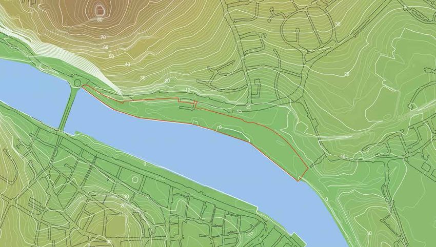
WATERFORD NORTH QUAYS STRATEGIC DEVELOPMENT ZONE - PLANNING SCHEME 2018
01 - INTRODUCTION

            1.1 Background
            During 2015 Waterford Council decided to seek
            SDZ designation for the North Quay Area of the
            City. The site measuring 8.23 Hectares (Ha) in
            extent has almost 1Km frontage along the River
            Suir and has an average depth of 75 meters.
            The lands are the whole of the lands formally used for port
            related activity and rendered redundant by the transfer of the
            port activities to a deep water berth down river at Belview in
            the early 1990’s.

            The site incorporates lands owned by the Port of Waterford
            Company (The North Quay and Frank Cassin Wharf)
            and lands owned by Waterford City and County Council
            (the former IAWS grain handling facility on the centre of
            the quays).

            Waterford City is a city in transition, traditionally dependant
            on manufacturing with port infrastructure. It is now in a move
            to high end manufacturing, internationally traded services
            and tourism. The redevelopment of the North Quays will
            feed into this change by enhancing and accelerating this
            transformation and propelling the City forward.

                                                                                      Figure 1: SDZ Context Map

2.     NORTH QUAYS PLANNING SCHEME                                            NORTH QUAYS PLANNING SCHEME         3.
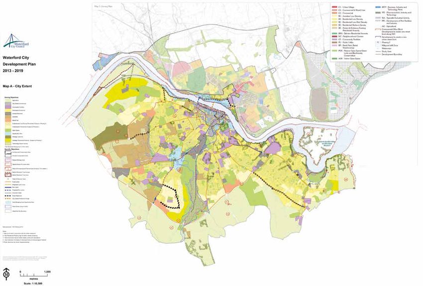
WATERFORD NORTH QUAYS STRATEGIC DEVELOPMENT ZONE - PLANNING SCHEME 2018
Kells
                                                                                                                                                               Abbeyleix
                                                                                                                                                                                                                                                            Ceanannas Mor                                              Laytown /
                                                                                                                                                                                                                                                                                                                       Bettystown/
                                                                               to Limerick                                                                                                                                                                          Navan                                              Mornington

                                                                                                                                         Rathdowney                                                  to Rosslare
           01 - INTRODUCTION                                                                                                                                                                                        to Mullingar,
                                                                                                                                                                                                                    Tullamore
                                                                                                                                                                                                                                                       Athboy                                Duleek
                                                                                                                                                                                                                    and Athlone
                                                                                                                                                                                                                                                                                                                        Balbriggan

                      1.2 National Policy                                                                                                                                                                          to Sligo,
                                                                                                                                                                                                                                        The National Planning Framework (NPF)
                                                                                                                                                                                                                                        “Ireland 2040”Trim
                                                                                                                                                                                                                                                                              Dunshaughlin
                                                                                                                                                                                                                                                       (replaces the NSS) is currently
                                                                                                                                                                                                                                                                                              Ratoath                 Lusk
                                                                                                                                                                                                                                                                                                                                            Rush
                                                                                                                                                                                      to Waterford                 Castlebar                                                                       Ashbourne
                                                                                                                                                                                                                   and Galway           at draft consultation stage. The Draft NPF
                      The North Quay has been acknowledged as a key strategic site for economic and
                                                                                                                                                                                                                                        identifies that the population of Waterford                                  Swords
                      social development at National level. The National Spatial Strategy 2002 (NSS)                                                                                                                                                                            Dunboyne
                                                                                                                                                                                                                                                                                   Mulhuddart
                                                                                                                                      to Cork                                                                                           City needs to reachEnfield
                                                                                                                                                                                                                                                             a critical mass of 83,000
                      describes the development of the North Quays as an “opportunity for consolidating                                                                                                                                 persons in order to Maynooth
                                                                                                                                                                                                                                                            function as an effective                                 Dublin
                                                                                                                                                                                                                                                                                                                     Metropolitan
                      Waterford City around the River Suir”.
                                                                                                                                                                                                                                                                                              Leixlip
                                                                                                                                                                                                                                        and sustainable city in its own right and as a                               Area
                                                                                                                                                                                                                                                                      Clane    Celbridge
                                                                                                                                                                                                                                        regional economic driver.                                 Lucan
                      It was also envisaged that the “renewal and development of the North Quays”, along with infrastructure and                                                                                                                                                                                                      Dun Laoghaire

                      transport improvements were some of the key investment priorities for Waterford.                                                                                                                                  The Draft NPF also identifies that the future
                                                                                                                                                                                                                                                                                 Tallaght
                                                                                                                                                                                                                                           Rathangan                 Naas
                                                                                                                                                                                                                                        developmentNewbridge         Kill
                                                                                                                                                                                                                                                    should provide a more balanced
                      The North Quays regeneration was included in the National Development Plan dating back to 2007                                                                                                                                       Droichead Nua                                                                      Bray
                                                                                                                                                                                                                                        and sustainable pattern to that which has
                      and more recently the site’s strategic importance has also been reflected in the Governments Capital                                                                                                                                                                   Blessington             Enniskerry
                                                                                                                                                                                                                                        resulted in city expansion predominantly                                                                   Greystones
                      Investment Plan – 'Building on Recovery: Infrastructure and Capital Investment 2016-2021.'                                                                                                                                 Kildare
                                                                                                                                                                                                                   to Cork,
                                                                                                                                                                                                                   Limerick              to the south. The Planning
                                                                                                                                                                                                                                    Monasterevin                 EustaceScheme aligns
                                                                                                                                                                                                                                                                 Ballymore
                                                                                                                                                                                                                                                                                                                                                   Kilcoole
                                                                                                                                                                                                                   and Tralee                                   Kilcullen
                                                                                                                                                                                                                                        with the Draft NPF in that its objective is to
                                                                                                                                                                                                                                                                                                                                      Newtownmountkennedy
                                                                                                                                                                                                                                        enable Waterford to become a regional city
                                                                                                                                                                                                                                                                                                                                  Rathnew
                                                                                                                                                                                                                                        of Athy
                                                                                                                                                                                                                                            scale, leading the economic recovery for
                                                                                                                                                                                                                                                                                                                                                     Wicklow
                                                                                                 to Athlone                                 to Dublin
                                                                                                                                                                                                                                        the South East and expanding and enhancing
                                                                                                                                                                                                                                                                                                                     Rathdrum
                                                                                    to Dublin                                                                                                                                           the local economy to realise
                                                                                                                                                                                                                                                              Baltinglass the potential of

                                                                                                                                                                                     to Dublin                                          the City and the region as a whole. One of
                                                                                                                                                                                                                                        theCarlow
                                                                                                                                                                                                                                            key future growth enablers for Waterford
                                                                                                                                           Tullow
                                                                                                                                                                                                                                        as set out in the Draft NPF is the delivery of
                                                                                                                           Carlow
                                                                                                                                                                                                                                        the North toQuays
                                                                                                                                                                                                                                                     WaterfordSDZ together with a new
                                                                                                    Castlecomer                                                                                                                                                                                                                      Arklow
                                                                                                                                                                                                                                        pedestrian /public transport bridge.
                                                                                                                               Bagenalstown                                          Gorey
                                                                                                                               Muine Bheag                                                                                              The objectives contained within the Planning Scheme allow for the realisation of this project. The North
                                                                                                     Kilkenny
                                                                                                                                                        Bunclody
                                                                                                                                                                                                                                        Quays redevelopment is a significant opportunity to provide for mixed use development at the heart of
                                                                                                                                                                                                                                                                                                        to Wexford
                                                                                                                                                                                                                                        the city, just north of its historic core. Theand Rosslare
                                                                                                                                                                             Ferns
                                                                                                                                                                                                                                                                                       site can achieve high density mixed use city centre commercial
                                                                                     Callan                                                                                                                                             development with a significant portion of retail development supported by office/hotel/tourism/residential
                                                                                                                              Graiguenamanagh
                                                                                                                                                             Enniscorthy                                                                development and most importantly a new transport hub.
                                      Cashel                                                                  Thomastown
                                                                                                                                                                                                                                        This latter element will enhance the attractiveness of the overall site for future investment and will future
               Tipperary                           Fethard
                                                                                                                                                                                                                                        proof that investment in terms of sustainability .

                           Caher         Clonmel             Carrick-on-Suir                                                         New Ross

                                                                                                                                                                   Wexford
                                                                                                                                                                                                                                        1.3 Regional Policy
                                                                                                                                                                                     Rosslare
                                                                                                                                                                                                                                        The South-East Regional Planning Guidelines (2010-2022) identifies the development
ork                                                                                                       Waterford
                                                                                                                                                                                                                                        of the North Quays as an exciting opportunity to enhance the attractiveness of areas
                                                                                                Tramore                    Dunmore
                                                                                                                                                                                                                                        for people and business.
                                                                                                                           East

                                                                                                                                                                                                                                        In particular the Guidelines identify that “significant expansion of the commercial, cultural and civic centre
                                   Lismore
                                                             Dungarvan                                                                                                                                                                  of Waterford City through investment in, and support for, the redevelopment of the North Quays” is a
                                                                                                                                                                                                                                        specific priority of the Guidelines while the provision of a new rail passenger platform and public transport
                                                                                                                                                                                                                                        interchange will also be achieved on the North Quays.
                to Cork

                                                                                                                                                                                                                                        It is expected that once prepared the Regional Spatial and Economic Strategy for the South East Region will
                                      Youghal
                                                                                                                                                                                                                                        support the SDZ Government designation of the North Quays.

           Figure 2: National Spatial Strategy Map

      4.     NORTH QUAYS PLANNING SCHEME                                                                                                                                                                                                                                                                                                                        NORTH QUAYS PLANNING SCHEME   5.
WATERFORD NORTH QUAYS STRATEGIC DEVELOPMENT ZONE - PLANNING SCHEME 2018
01 - INTRODUCTION

            1.4 Waterford Planning Land
            Use and Transportation
            Strategy (PLUTS) 2004-2020
            The Waterford Planning Land Use and Transportation
            Strategy (PLUTS) 2004-2020 provides a vision and strategy
            for the development of Waterford City and Environs to 2020
            and that a key city development challenge is to fully harness
            its river front potential as a central focus for the development
            of a new Irish urban experience.
            The PLUTS seeks to readdress the current spatial imbalance bringing the
            northern side of the River Suir fully within the economic and social ambit
            of an expanded Waterford City.

            The development of the North Quays as a northward extension of the
            existing City Centre has been highlighted as one of the key components
            of the spatial strategy for Waterford.

            The principal features of the PLUTS include:

            •   More balanced growth between north and south sides of the
                River Suir.
            •   A new City Centre bridge exclusively for pedestrians and cyclists
                linking the redeveloped North Quays with the existing City Centre.
            •   Provision of a rail passenger platform on the North Quays as part
                of a new public transport hub.
            •   Development of a high-quality bus-based public transport system in
                the City.

                                                                                                      Figure 3: PLUTS Map

6.     NORTH QUAYS PLANNING SCHEME                                                       NORTH QUAYS PLANNING SCHEME        7.
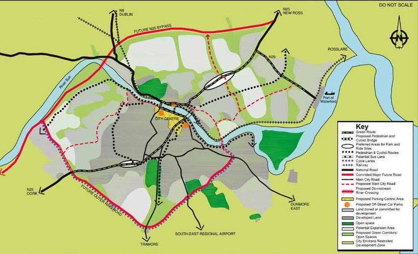
WATERFORD NORTH QUAYS STRATEGIC DEVELOPMENT ZONE - PLANNING SCHEME 2018
01 - INTRODUCTION

            1.5 Waterford City
            Development Plan
            2013-2019
            The North Quay area is zoned as a “mixed use opportunity
            site” on the objectives map in the Development Plan.
            A range of mixed uses including retail, office and residential
            are permissible on the site under this zoning.
            The Plan also states that any future development proposal on the North
            Quays shall generally conform to the principles set out in the Waterford
            Urban Design Framework Plan for the North Quays 2008 (referred to
            further in section 1.6).

            Section 5.3.4 of the Waterford City Development Plan relates to the North
            Quays and reiterates the PLUTS classification of the North Quays as a
            primary redevelopment area, with a proposed new City Centre bridge for
            pedestrians and cyclists and the provision of a new rail platform on the
            North Quays as part of a public transport interchange. It highlighted that
            any master plan for the North Quays must investigate the feasibility of
            providing such a bridge in conjunction with the development and must
            take into account the requirements of Iarnrod Eireann in relation to the
            operation and development of rail services on and through the site. It is an
            objective of the Development Plan to provide for a riverside promenade
            along the northern bank of the Suir, as part of the redevelopment of the
            North Quays, from Rice Bridge to the City boundary.

            It is an objective of the City Plan to maintain the views and vistas from the
                                                                                                                                   The Development Plan identifies the following key transport objectives
            South Quays to the north and from the North Quay to the south as per
                                                                                                                                   specific to the North Quays:
            the Waterford Urban Design Framework Plan for the North Quays 2008.
                                                                                                                                   •   To provide an appropriately designed and constructed pedestrian
            The Development Plan identifies that the relocation of the port has
                                                                                                                                       river crossing located in the vicinity of the Clock Tower to provide
            resulted in a positive alteration to the general environment of the City’s
                                                                                                                                       accessibility to the North Quays and facilitate future development.
            waterfront with activities thereon becoming more closely aligned with the
            tourism and leisure sector, for example accommodating small to medium                                                  •   Investigate the feasibility of provision of an open span bridge facilitating

            sized cruise ships utilising the deep water wharves stretching between          Figure 4: Waterford City Development       a light public transport system in the vicinity of Reginald’s Tower linking

            Rice Bridge and Abbey Church.                                                           Plan 2013-2019 (Zoning Map)        up with future development on the North Quays. The provision of such
                                                                                                                                       a looped transport system in the City is desirable. There is an option
                                                                                                                                       for such a looped transport system also being facilitated via a new
                                                                                                                                       sustainable transport bridge at the Clock Tower as per the North Quays
                                                                                                                                       Urban Design Framework.

                                                                                                                                   •   To provide for a sustainable riverside walk along the northern bank of the
                                                                                                                                       Suir, as part of the redevelopment of the North Quays.

8.     NORTH QUAYS PLANNING SCHEME                                                                                                                                             NORTH QUAYS PLANNING SCHEME            9.
WATERFORD NORTH QUAYS STRATEGIC DEVELOPMENT ZONE - PLANNING SCHEME 2018
01 - INTRODUCTION

             1.6 Previous Plans for North Quays                                                                                 1.7 Strategic Development Zone (2016)
             The SDZ designation is the culmination of a series of studies of the North Quays                                   The SDZ designation was conferred on the North Quays by Government on the 20th of
             undertaken over the years.                                                                                         January 2016 (SI 30 of 2016), in recognition of its economic or social importance to the
             In October 1998, the Architectural Service of the Office of Public Works (OPW) prepared a Development Vision       State. The Development Agency Waterford City & County Council (WCCC) is required
             for the North Quays. The vision for the development proposed the following elements:                               to prepare a draft Planning Scheme within 2 years of the Government's Order.
             •   Commuter ferry, spine road, pedestrian walk, hotel and marina, venue building, mixed use development,          Section 168(2) of the Planning and Development Act 2000 (as amended) identifies the key requirements of any
                 cruise liner docking and public spaces.                                                                        designated planning scheme which shall consist of a written statement and a plan indicating the manner in which
             The final design proposed buildings of varying height oriented perpendicular to the riverfront, in parallel        it is intended that the site or part of the site is to be developed and in particular:
             lines, and public space located strategically where the river bends, to expose long distance views.                •    The type or types of development which may be permitted to establish on the site.
             The Waterford Urban Design Framework Plan for the North Quays (2008) which incorporated the key elements           •    The extent of any such proposed development.
             of the 1998 OPW Study and set out a broad vision for the area comprising development concepts and urban
                                                                                                                                •    Proposals in relation to the overall design of the proposed development, including the maximum
             design guidelines.
                                                                                                                                     heights, the external finishes of structures and the general appearance and design.
             The framework also proposed the provision of a new bridge to provide easy access to the existing bus station and
                                                                                                                                •    Proposals relating to transportation, including public transportation, the roads layout, the provision of
             better connectivity with the core shopping area in the City Centre.
                                                                                                                                     parking spaces and traffic management.

                                                                                                                                •    Proposals relating to the provision of services on the site, including the provision of waste and sewerage
                                                                                                                                     facilities and water, electricity and telecommunications services, oil and gas pipelines, including storage
                                                                                                                                     facilities for oil or gas.

                                                                                                                                •    Proposals relating to minimising any adverse effects on the environment, including the natural and
                                                                                                                                     built environment, and on the amenities of the area.

                                                                                                                                •    Where the scheme provides for residential development, proposals relating to the provision of
                                                                                                                                     amenities, facilities and services for the community, including schools, créches and other education
                                                                                                                                     and childcare services.

                                                                                                                                The Planning and Development Act 2000 (as amended) requires that development within an SDZ be in accordance
                                                                                                                                with the relevant planning scheme and that any proposed development which is deemed to comply with the
                                                                                                                                planning scheme must be granted planning permission.

                                                                                                                                                                                                                         Figure 5: SDZ & Planning Scheme Area

10.     NORTH QUAYS PLANNING SCHEME                                                                                                                                                                                      NORTH QUAYS PLANNING SCHEME            11.
WATERFORD NORTH QUAYS STRATEGIC DEVELOPMENT ZONE - PLANNING SCHEME 2018
01 - INTRODUCTION

              1.8 SEA & AA                                                                                                      SAC, adjoining the site and the River Barrow and River Nore SAC located downstream of the SDZ. The AA
                                                                                                                                Screening concluded on the basis of objective information that significant effects are likely, or cannot be
                                                                                                                                ruled out, therefore full AA (Stage 2) is required.
              1.8.1    Strategic Environmental Assessment and Appropriate Assessment
              The Planning Scheme has been prepared in accordance with the requirements of the Planning and Development         Stage 2 of AA involved a scientific analysis of the potential impacts of the Planning Scheme on the habitats
              Act, 2000 (as amended), the Planning and Development (Strategic Environmental Assessment) Regulations 2004        and/or species for which the Natura 2000 sites “screened in” at Stage 1 are selected.
              and Article 6 of the Habitats Directive 92/43/EEC. The Strategic Environmental Assessment (SEA) and Appropriate
              Assessment (AA) processes, undertaken in tandem with the preparation of the Planning Scheme, have ensured full    The Draft Natura Impact Report (NIR) examined, analysed and evaluated the implications of the Draft
              integration and consideration of environmental issues throughout each stage of the preparation process.           Planning Scheme for European sites, specifically the Lower River Suir SAC and the River Barrow and River
                                                                                                                                Nore SAC, in order to assist Waterford City & County Council, as the competent authority, in undertaking
              1.8.2    Strategic Environmental Assessment                                                                       the Appropriate Assessment (AA). The NIR concluded that, given the full and proper implementation of the
                                                                                                                                relevant Principal Goals and Specific Objectives of the Planning Scheme, which are highlighted in Section 6
              Strategic Environmental Assessment (SEA) is the formal, systematic evaluation of the likely significant           of the NIR, the Planning Scheme, either individually or in combination with other plans or projects, will not
              environmental effects of implementing a plan or programme before a decision is made to adopt the plan             adversely affect the integrity of the Lower River Suir SAC, the River Barrow and River Nore SAC or any other
              or programme. SEA is a mandatory requirement during the preparation of a Planning Scheme for Strategic            Natura 2000 site, in view of their Conservation Objectives.
              Development Zones. The purpose of the SEA is to systematically identify and evaluate the likely significant
              environmental effects arising from the implementation of the Planning Scheme.

              The process of SEA is an iterative one and has been used to inform the Planning Scheme including changes
              to maps and objectives and/ or wording of the Planning Scheme. The SEA process is recognised as a central
                                                                                                                                1.9 Vision for the North Quays
              mechanism in promoting sustainable development, in raising awareness of the significant environmental             1.9.1       To create a sustainable, compact extension to the City Centre that will serve
              issues experienced in an area and ensuring that these issues are addressed through the planning system in         a future population of a 83,000 people
              the form of amendments to text or maps.
                                                                                                                                The vision for the area will be to create a sustainable modern mixed use quarter connected to, consolidating

              The likely significant environmental effects of the Planning Scheme are identified and their significance         and extending the City Centre while facilitating the development of the northern city environs and respecting

              evaluated with regard to the environmental baseline. The Environmental Report accompanying the Planning           its historic and natural environment on the River Suir.

              Scheme provides relevant information to the decision-makers, the members of the Council, who decide               The area will act as a model in integrating smart, innovative and sustainable solutions into all aspects of the
              whether or not to accept the Planning Scheme, as well as to the public, providing a clear explanation of          environment including land use, building design and public realm.
              the likely significant environmental effects of the Planning Scheme. These issues, along with consultation
                                                                                                                                The development of the North Quays will reinstate the primacy of the river by creating a compact city core
              responses have been considered as part of the final Planning Scheme and Environmental Report and will
                                                                                                                                centred on the River Suir.
              be documented as part of the SEA Statement.
                                                                                                                                1.9.2       A regeneration catalyst for the City and Region and the establishment of a
              1.8.3    Appropriate Assessment
                                                                                                                                sustainable modern city quarter
              The Lower River Suir is designated a Special Area of Conservation (SAC) under the Habitats Directive. Article     The opportunity exists for a transformative development that can become a regeneration catalyst for the
              6(3) of the Habitats Directive (92/43/EEC) states that any plan or project not directly connected with or         City and Region. It would have national exposure such is the importance and significance of the site and
              necessary to the management of a Natura 2000 site, i.e. Special Area of Conservation (SAC) or Special             location.
              Protection Area (SPA), but likely to have a significant effect thereon, either individually or in combination
                                                                                                                                The renewal of the North Quays is seen as essential to the proper expansion of the city core and the
              with other plans or projects, shall be subject to an Appropriate Assessment (AA) of its implications for the
                                                                                                                                balanced future development of the city to the north of the River Suir with the North Quays acting as a
              site in view of the site's Conservation Objectives. The Appropriate Assessment has been carried out in
                                                                                                                                focus for this renewal.
              parallel with the drafting of the Planning Scheme and is prepared as a separate document accompanying
              the Planning Scheme.
                                                                                                                                1.9.3       Creation of an integrated multi-modal transport hub designed to sustainably
              Stage 1 of AA (Screening) involved assessing the Planning Scheme in principle and determining the                 meet the access requirements of The City
              likelihood of significant effects on Natura 2000 sites as a result of its implementation, either individually
                                                                                                                                The Transportation Vision is to develop and promote a modal shift away from private car towards increased
              or in combination with other plans or projects. The AA Screening considered that there was potential for
                                                                                                                                use of an integrated multi-modal sustainable transport network to include: walking, cycling and public
              the Draft Planning Scheme to have an adverse effect on certain Qualifying Interests of the Lower River Suir
                                                                                                                                transport integrating bus and rail.

12.     NORTH QUAYS PLANNING SCHEME                                                                                                                                                                             NORTH QUAYS PLANNING SCHEME       13.
01 - INTRODUCTION

               Specifically, it is proposed to relocate the train station to the North Quays close to the new sustainable             •   Provide a dynamic new economic engine for the City and Region.

               transport bridge creating a new integrated transport hub. A city centre bus service will connect the North             •   To promote the expansion of the City Centre to the north of the River Suir in a manner that enhances

               Quays/ railway station across the sustainable transport bridge and along the length of the retail spine to                 and supports balanced and sustainable growth in Waterford City and encourages its vitality and viability.

               Michael Street. This would integrate a diverse retail offer connecting new shopping centres with traditional streets   •   To link the north and south side of the city by providing a new sustainable transport bridge crossing and

               and shop frontages. The Greenway connecting Dungarvan to New Ross will cross the site using the new                        improve accessibility and connectivity by creating an environment that facilitates internal pedestrian

               sustainable transport bridge and be incorporated into the development of the North Quays site.                             and cycle movements.
                                                                                                                                      •   To provide a rich and diverse mix of uses where a sustainable balance of retail, working, living and
               Within the site, pedestrian access will be provided along the sensitive river edge by means of a riverside                 recreation can be achieved.
               promenade with the service access road forming a spine road remote from the river edge parallel to the                 •   To develop a design led scheme of high quality architectural merit.
               railway line either above or below ground. An integrated parking strategy north and south of the river will            •   To balance the employment, retail and commercial base of the North Quays with the future residential
               be put in place with a balanced provision of parking on the North Quays with Park and Ride options made                    growth of the City and the South East Region.
               available.                                                                                                             •   To provide a sustainable transport hub on the North Quays.
                                                                                                                                      •   To provide for sustainable patterns of movement and access with priority for pedestrians, cyclists and
               1.9.4    Building on the context and the riverside location of the site to create a high                                   public transport.
               quality urban quarter as a natural extension of the City Centre                                                        •   To promote quality design of the spaces between and around buildings, the public realm that connects
                                                                                                                                          the various elements of the North Quays together including the wider hinterland.
               To capitalise, enhance and respect the site’s assets; its long south facing river frontage, panoramic views
                                                                                                                                      •   To create a safe, accessible and socially cohesive environment where people of all ages and abilities
               and proximity to the existing historic city core.
                                                                                                                                          can live, work and relax.
               To bring to bear an architectural skill set with the experience and expertise to deliver a scheme of high              •   To provide sustainable infrastructure and services for future populations.
               design merit that would have the confidence to bring a new and exciting interpretation of the quays while              •   To provide for the protection, enhancement and improvement of the natural environment, including
               respecting its maritime past and the traditional streetscape of the South Quays that has developed over                    the avoidance of adverse effects on European sites, particularly the Lower River Suir SAC and the River
               many centuries.                                                                                                            Barrow and River Nore SAC.
                                                                                                                                      •   To create a sustainable urban environment, which respects it's natural, historic and cultural heritage.
                                                                                                                                      •   To provide sustainable solutions that address and manages the risk of flooding and climate change.

               1.10 Principal Goals                                                                                                   •   To promote the incorporation of resource energy efficiency and waste management into the area.

               •   To create a strong and complementary extension of the City Centre.                                                 The principal goals are supported by attainable steps referred to as specific
               •   To form a sustainable, smart connected urban area of regional significance acting as a gateway to the City.        objectives throughout the Planning Scheme.

      Figure 6: Existing & Proposed Land Use Quarters

14.     NORTH QUAYS PLANNING SCHEME                                                                                                                                                                                 NORTH QUAYS PLANNING SCHEME       15.
02
                                    SITE CONTEXT
16.   NORTH QUAYS PLANNING SCHEME            NORTH QUAYS PLANNING SCHEME   17.
02 - SITE CONTEXT

              2.1 Site Description
              & Context
              The SDZ site has a very significant presence in Waterford
              City, forming part of the City Centre and being visible
              from the main northern approaches to the City as well
              as from the City Centre and South Quays. The site has a
              south facing aspect and has extensive redevelopment
              capacity having contained structures and silos of up to
              39 metres Ordnance Datum (OD).
              The total area of the SDZ site is 8.23 Ha and consists predominantly
              of under utilised former commercial docks. The land included in the
              Planning Scheme is identified in Figure 5. The extent of the Planning
              Scheme reflects a sequential approach to development and the need to
              ensure the effective consolidation of brownfield sites and optimisation
              of public investment on infrastructure. The lands to which the Planning
              Scheme applies varies between approximately 40m and 100m in width
              and is contained between the River Suir to the south and the railway
              line/Dock Road to the north. The distance between the north and south
              quays varies but is approximately 220 metres.

              The North Wharf which lies closest to Rice Bridge forms the narrowest
              part of the site and lends itself to amenity space, commercial and
              residential uses. The mid section which lies adjacent to the new bridge
              crossing, has potential for greatest activity/footfall and lends itself to retail                                            There is a collection of houses along Sion Row to the north of the site, some of

              uses while Frank Cassin Wharf (the broader eastern end of the site) can                                                      which are now uninhabitated. The existing retail is minimal and caters to the local

              accommodate a greater mix of uses such as commercial and residential.                                                        market. Ferrybank neighbourhood extends to the north catering for large areas of
                                                                                                                                           residential development.
              The natural landscape behind the quays rises sharply at Mountmisery and
              Mount Sion and forms a substantial backdrop to the site when viewed                                                          This area is bordered by educational uses to the east and mixed uses further south.

              from the City Centre/South Quays. The Dock Road and railway line run                                                         The south-east end of the docks is bounded by significant trees and forms an

              parallel between the quays and the high ground until the railway slips                                                       attractive foreground to the Abbey Church. Above the site to the west there are

              under the road as it meets Rice Bridge. The distance between the opposing                                                    the well maintained and extensive grounds of Sion Hill House, which neighbours

              waterfronts offers full vistas of both sides from almost any viewpoint.                                                      the even more expansive landscaped and increasingly steep bluff from which the

              Panoramic views are afforded from any point in the site at present with                                                      former Ard Rí Hotel site dominates views to and from the city. Below the cliff and
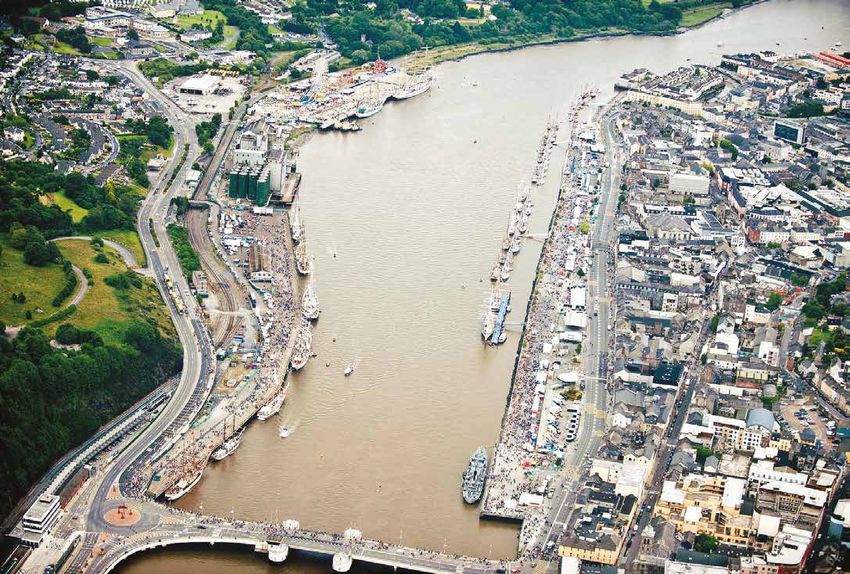
                                                                                                     Figure 7: North & South Quays -
              reciprocal views to the north from the southern waterfront and framed               Tall Ships Festival 2011 (Aerial View)   at the far west end of the site lies Plunkett Railway Station.

              views created through the streets that lie perpendicular to the river.                                                       The National Inventory of Architectural Heritage (NIAH) identifies the former R&H

              In terms of land use and activities it must be noted that industrial activity                                                grain store (Hennebique building) as a building of architectural significance. The

              on the waterfront has moved on, leaving the site redundant. Some                                                             former industrial building cannot be easily altered or adapted for alternative uses

              light industry remains on land adjacent and to the north east of the site                                                    due to the nature of its construction. The future use of the building is therefore

              including the Bus Éireann depot and small scale commercial uses.                                                             not viable. The removal of this building will be required to facilitate development
                                                                                                                                           on the site. The removal of the building would be dealt with under Part 8 of the
                                                                                                                                           Planning and Development Regulations (as amended).

18.     NORTH QUAYS PLANNING SCHEME                                                                                                                                                        NORTH QUAYS PLANNING SCHEME           19.
02 - SITE CONTEXT

              2.2 Historical Context
              The City has developed over the centuries almost entirely
              on the south bank of the River Suir. For most of the
              historical period the commercial and port activity of
              Waterford City has centred on the South Quays. Dock
              Road itself which bounds the site to the north dates from
              the completion of the Timber Toes Bridge in 1794 spanning
              from what is now known as Bridge Street to Dock Road
              replacing the former ferry crossings.
              In the early 19th Century the North Quay was largely a location for ship
              building with firms such as Pope & Co., William White and Charles Smith
              all located within the area. The former R & H Hall Mill dates from 1905
              designed by William Friel utilising Francois Hennebique’s reinforced
              concrete technique. It was surrounded by a collection of additional
              warehouses and silos that developed throughout the 20th Century which
              have recently been demolished.

              North on the hill overlooking Waterford City is the early 19th Century Sion
              Hill House which operates as a bed and breakfast with the gardens which
              are open to the public.

              There are no protected structures or recorded archaeological sites located
              within the Planning Scheme area.

                                                                                            Note: Height of historical buildings in background (7-8 floors)

20.     NORTH QUAYS PLANNING SCHEME                                                                                NORTH QUAYS PLANNING SCHEME                21.
02 - SITE CONTEXT

              2.3 Physical Constraints                                                      A

              2.3.1    The River
              The North Quays contiguous to the existing City Centre but is
              disconnected from the South Quays by the Suir River which is 200
              meters wide at this point. The only river crossing is at Rice Bridge which
              is at the western extremity of the site.
                                                                                            B
              2.3.2    The Railway
              The route of the railway line along the northern boundary of the site
              forms a barrier to movement to and from the North Quays from Dock
              Road and Fountain Street. Access is provided by means of a railway level
              crossing and an old stone vehicular bridge which is restrictive in terms of
              its narrow width, an acute bend, slope and junction layout with the Dock
              Road and the North Quays.                                                     C

              2.3.3    Traffic
              The volume of traffic utilising Dock Road and Rice Bridge also form
              barriers to pedestrian and cyclist movement between the north city and
              the quay site.
                                                                                            D
              2.3.3    Flooding
              The Planning Scheme area borders the River Suir for approximately
              1km on its southern boundary, this section of the River Suir is tidal         E
              and portions of the site are indicated to be within flood zones A &
              B in the OPW South Eastern CFRAM study. A Strategic Flood Risk
              Assessment has been carried out in the preparation of the Planning
                                                                                            F
              Scheme. This assessment is an area wide assessment of the existing
              risks of flooding and the impact of those risks arising from proposed
              development on the site. The layout, design, finished floor levels and
              specific land uses set out in the Planning Scheme have considered             G
              the conclusion and recommendations of the Strategic Flood Risk
              Assessment and incorporated same in order to be consistent with the
                                                                                                Top to Bottom - Figure 8: Constraints Map; Figure 9: Existing Site Sections
              Planning System and Flood Risk Management: Guidelines for Planning
              Authorities 2009 (OPW).

22.     NORTH QUAYS PLANNING SCHEME                                                                                                NORTH QUAYS PLANNING SCHEME                23.
02 - SITE CONTEXT

              2.4 Landscape
              & Topography
              The area is physically and visually contained between the
              River Suir and elevated lands to the north.
              To the west the land rises steeply to over 85m OD, the highest point
              proximate to the site and is characterised by an attractive mixture of
              natural informal and broken wooded landscape.

              The former Ard Ri Hotel sits on a platform circa the 50m OD mark and the
              general skyline in this area is of mature tree canopies.

              The central zone to the north is characterised predominately by residential
              development on a steep slope. Pockets of open space create a buffer
              between residential development and the Dock Road below. To the east
              of the site there is an attractive natural landscape following the course of
              the river including significant tree stands surrounding Abbey Church.

                                                                                                       Figure 10: Contours Map

24.     NORTH QUAYS PLANNING SCHEME                                                          NORTH QUAYS PLANNING SCHEME         25.
02 - SITE CONTEXT

              2.5 Existing City Centre
              The existing City Centre is located on the south side of
              the River and is characterised by its fine grain mixed use
              waterfront, a historic quarter focussed on Reginald’s
              Tower, a retail quarter and cultural uses supported by
              mixed use developments to the south and west.
              To date , save for the port related uses on the North Quays, the City Centre
              has been focused on the South Quays, which has hindered the sustainable
              concentric growth of the City, reduced the economies of scale in the
              provision of infrastructure and put pressure for development on “out of
              town “ areas.

              Such pressure has been largely resisted but the consequent lack of suitable
              sites in the City Centre has resulted in a constrained retail offering which
              has exacerbated the problem of retail leakage from the region.

              The redevelopment of the North Quays will redefine the existing City
              Centre and key to this will be the sustainable transport bridge which will
              provide necessary connectivity but also create a more central focus from
              which the City Centre can concentrically grow as envisaged under PLUTS.

                                                                                                      Figure 11: Concentric City

26.     NORTH QUAYS PLANNING SCHEME                                                          NORTH QUAYS PLANNING SCHEME           27.
03
                                    PHYSICAL
                                    & SOCIAL
                                    INFRASTRUCTURE
                                    Part a : Access & Connectivity

28.   NORTH QUAYS PLANNING SCHEME                           NORTH QUAYS PLANNING SCHEME   29.
03 - PHYSICAL & SOCIAL INFRASTRUCTURE

               3a.1 Access Strategy                                                                                                3.   A sustainable transport bridge capable in width to accommodate pedestrians, cyclists and a City Centre
                                                                                                                                        bus service should be built from the North Quay to the South Quay in the vicinity of the Clock Tower
                                                                                                                                        on the South Quay. Such a bridge would provide
               It is a fundamental requirement of the Planning Scheme to ensure that the future
                                                                                                                                        • Direct access to the exiting City Centre for pedestrians and cyclists.
               demands for travel are met in a sustainable way. The Scheme envisages the North
                                                                                                                                        • A vital link in the connection of the Waterford Greenway to the proposed Dublin - New Ross -
               Quays developing as a transport hub facilitating not alone the mixed use development
                                                                                                                                          Waterford Greenway.
               on the North Quays but the entire city. The strategy of the scheme is to limit car                                       • An opportunity for the retail sector in the city to operate a courtesy shuttle which could connect
               usage by making alternative modes of transport more accessible and attractive.                                             the extremities of the City Centre together.

               The main physical constraints as outlined in Chapter 2 are as follows:
                                                                                                                                   A Strategic Flood Risk Assessment carried out for the Waterford City Development Plan 2013-2019 has also
               •    Remoteness of the site from the South Quays and the remainder of the City Centre.                              identified that the land area on the North Quays would have to be raised in order to meet the requirements
               •    Access from its immediate road network.                                                                        in relation to flood risk in the area.
               •    Flood protection requirements to raise substantial areas of the site above the design flood heights.
                                                                                                                                   The existing quays are approximately at 2.75m above Ordnance Datum (OD). It is necessary to provide flood
               The City and County Council have undertaken a substantial body of work to resolve the access problem                protection to a height of 4.42m OD as a minimum. Also, overcoming the barrier formed by the railway to
               and it has been determined that:-                                                                                   the north of the site and providing proper integration with the Dock Road requires that the floor levels of
                                                                                                                                   the site should be raised to somewhere between 6m OD and 9m OD. Access routes provided north/south
               1.   The existing access points to the site from the Dock Road are deemed to be inadequate and present a
                                                                                                                                   through the development site should be fully integrated with the surrounding environment.
                    barrier to future development of the site. As a result, two new access points have been identified. One
                    at the upper eastern end of the site from a widened Abbey Road, and the other at the lower, western            Rather than simply raise the ground level by infill, the solution proposed is to construct a podium structure
                    end of the site by way of a new junction on the Dock Road and a new overbridge to the site. The                across the majority of the site, thereby both raising the future ground building height above the flood risk
                    existing level crossing from the Dock Road is not suitable and is therefore no longer required although        zone and also providing an opportunity to address the parking demands of the site in a discreet and efficient
                    the need for pedestrian permeability in this vicinity should be accommodated in some way as part of            fashion.
                    the site development.
                                                                                                                                   The work carried out by the Council has identified the alterations required to the surrounding road network
               2.   Access to parking, loading and unloading, waste management and all such development related traffic            and the associated infrastructural requirements required to address the access constraints in the vicinity of
                    should be contained within the site from an internal "spine" road constructed in a fashion that it would       the site, all of which are adjacent to but not included within the Planning Scheme area.
                    not become a visible feature when viewed from the South Quay and not forming a barrier to free
                                                                                                                                   The detailed analysis of access requirements has also identified that in order to achieve the objective
                    pedestrian movement across the site or along the waterfront. It is likely that such a road would be
                                                                                                                                   of creating a transport hub; the infrastructure requirements of such a hub would straddle the northern
                    parallel to the railway on the north of the site and the possibility exists for some or all of this internal
                                                                                                                                   boundary of the Planning Scheme area.
                    road to be contained below the buildings.

      Figure 12: Access Strategy

30.     NORTH QUAYS PLANNING SCHEME                                                                                                                                                                                NORTH QUAYS PLANNING SCHEME     31.
You can also read