Valle de Oro National Wildlife Refuge and Bernalillo County - U.S. Fish & Wildlife Service
←
→
Page content transcription
If your browser does not render page correctly, please read the page content below

U.S. Fish & Wildlife Service

Valle de Oro National Wildlife Refuge
                and
          Bernalillo County

           Draft Environmental Assessment for the
  Prescribed Endemic Refuge Connected Habitat Areas Project
                Bernalillo County, New Mexico

                         June 2019
Contents
1.     Purpose and Need for the Project............................................................................................ 1
     1.1.    Introduction ...................................................................................................................... 1
     1.2.    Proposed Action ............................................................................................................... 1
     1.3.    Project Background .......................................................................................................... 4
     1.4.    Purpose and Need for the Proposed Action ..................................................................... 4
     1.5.    Other Applicable Statues, Executive Orders, and Regulations ........................................ 5
     1.6.    Public Outreach ................................................................................................................ 6
2.     Alternatives Considered .......................................................................................................... 7
     2.1.    No Action Alternative ...................................................................................................... 7
     2.2.    Proposed Action ............................................................................................................... 7
       Stormwater and Creation of Wildlife Habitat ......................................................................... 7
       Interpretive Displays ............................................................................................................... 8
       Connecting People to Nature and Improving Environmental Awareness .............................. 8
       Education ................................................................................................................................ 8
       Recreation ............................................................................................................................... 9
       Employment and Workforce Training .................................................................................... 9
       Increased Access to High-Quality Food ................................................................................. 9
3.     Affected Environment and Environmental Consequences ................................................... 11
     3.1.    Geology & Soils ............................................................................................................. 11
       Existing Conditions............................................................................................................... 11
       Effects on Geology & Soils .................................................................................................. 12
     3.2.    Vegetation (including vegetation of special management concern) .............................. 12
       Existing Conditions............................................................................................................... 12
       Effects on Vegetation (including vegetation of special management concern) .................... 14
     3.3.    Wildlife and Aquatic Species ......................................................................................... 14
       Existing Conditions............................................................................................................... 14
       Effects on Wildlife and Aquatic Species .............................................................................. 16
     3.4.    Bird Aircraft Strike Hazard ............................................................................................ 16
       Existing Conditions............................................................................................................... 16
       Effect on Bird Aircraft Strike Hazard ................................................................................... 18
     3.5.    Threatened and Endangered Species and Other Special Status Species ........................ 18
       Existing Conditions............................................................................................................... 18
       Effects on Threatened and Endangered Species and Other Special Status Species ............. 21

                                                                                                                                                  i
3.6.    Air Quality...................................................................................................................... 22
       Existing Conditions............................................................................................................... 22
       Effects on Air Quality ........................................................................................................... 23
     3.7.    Noise............................................................................................................................... 23
       Existing Conditions............................................................................................................... 23
       Effects on Noise .................................................................................................................... 24
     3.8.    Water Resources ............................................................................................................. 24
       Existing Conditions............................................................................................................... 24
       Effects on Water Resources .................................................................................................. 25
     3.9.    Wetlands and Floodplains .............................................................................................. 25
       Existing Conditions............................................................................................................... 25
       Effects on Wetlands and Floodplains ................................................................................... 26
     3.10.      Visitor Use and Experience ........................................................................................ 27
       Existing Conditions............................................................................................................... 27
       Effects on Visitor Use and Experience ................................................................................. 30
     3.11.      Cultural Resources ...................................................................................................... 30
       Existing Conditions............................................................................................................... 30
       Effects on Cultural Resources ............................................................................................... 36
     3.12.      Indian Trust Assets ..................................................................................................... 37
       Existing Conditions............................................................................................................... 37
       Effects on Indian Trust Assets .............................................................................................. 38
     3.13.      Socioeconomic............................................................................................................ 38
       Existing Conditions............................................................................................................... 38
       Local and Regional Economies ............................................................................................ 38
       Effects on Socioeconomics ................................................................................................... 39
     3.14.      Environmental Justice................................................................................................. 39
       Existing Conditions............................................................................................................... 39
       Effects on Environmental Justice.......................................................................................... 40
4.     Cumulative Impact Analysis: ................................................................................................ 40
     4.1.    Geology and Soils .......................................................................................................... 41
     4.2.    Vegetation ...................................................................................................................... 41
     4.3.    Wildlife and Aquatic Species ......................................................................................... 41
     4.4.    Air Quality and Noise .................................................................................................... 41
     4.5.    Water Resources ............................................................................................................. 41

                                                                                                                                                  ii
4.6.      Visitor Use and Experience ............................................................................................ 41
5.     Monitoring and Maintenance ................................................................................................ 42
     5.1.      Los Padillas Property ..................................................................................................... 42
     5.2.      Mountain View Property ................................................................................................ 43
     5.3.      McEwen Pond Property ................................................................................................. 43
     5.4.      Sanchez Farm Open Space ............................................................................................. 43
6.     Summary of Analysis ............................................................................................................ 44
7.     List of Sources, Agencies and Persons Consulted ................................................................ 45
8.     References ............................................................................................................................. 48
9.     List of Preparers .................................................................................................................... 54
10.         List of Reviewers ............................................................................................................... 54
11.         State Coordination ............................................................................................................. 54
12.         Tribal Consultation ............................................................................................................ 54
13.         Determination .................................................................................................................... 55
Appendix A- Prescribed Endemic Refuge Connected Habitat Areas (PERCHAS) Plan ............. 56
Appendix B- Wildlife Species Lists ............................................................................................. 57
Appendix C- Public and Tribal Scoping Letters ........................................................................... 61
Appendix D- Responses to Public and Tribal Scoping Letters..................................................... 62
Appendix E- Cultural Resources Coordination ............................................................................ 63

Table 3-1. Non-native and/or Invasive Vegetation Species in Action Area ................................. 14
Table 3-2. Federal and State of New Mexico Species of Concern in Bernalillo County ............. 19
Table 3-3. Bernalillo County Emissions ....................................................................................... 23
Table 3-4. Previously Recorded Resources within 500 m of the APE ......................................... 32
Table 3-5. Previously Conducted Investigations with 500 m of the APE .................................... 34
Table 3-6. Previously Recorded Resources within the APE......................................................... 36

Figure 1-1. Overview Map of PERCHAs Project. .......................................................................... 3
Figure 2-1. Overview of PERCHAs Property Habitat Improvements .......................................... 10

                                                                                                                                               iii
Acronyms

AFSCME    American Federation of        MRG       Middle Rio Grande
          State, County, Municipal      MRGCD     Middle Rio Grande
          Employees                               Conservancy District
AMAFCA    Albuquerque Metropolitan      MS4       Municipal Separate Storm
          Arroyo Flood Control                    Sewer System
          Authority                     NAAQS     National Ambient Air
AMRGI     Albuquerque – Mid Rio                   Quality Standards
          Grande Intrastate             NEPA      National Environmental
AOA       Airport Operations Area                 Policy Act
APE       Area of Potential Effects     NFWF      National Fish and Wildlife
AQCR      Air Quality Control Region              Foundation
BASH      Bird Aircraft Strike Hazard   NMAC      New Mexico Administrative
BISON-M   Biota Information System of             Code
          New Mexico                    NMCRIS    New Mexico Cultural
CAA       Clean Air Act                           Resources Information
CDC       Center for Disease Control              System
          and Prevention                NMDA      New Mexico Department of
CFR       Code of Federal Regulations             Agriculture
CINCH     Collective Impact for         NMDGF     New Mexico Department of
          Neighborhood and County                 Game and Fish
          Health                        NMED      New Mexico Environmental
CO        Carbon Monoxide                         Department
CO2       Carbon Dioxide                NMEMNRD New Mexico Energy,
CWA       Clean Water Act                         Minerals and Natural
EA        Environmental Assessment                Resources Department
EIS       Environmental Impact          NMOSE/ISC New Mexico Office of the
          Statement                               State Engineer/Interstate
EO        Executive Order                         Stream Commission
ESA       Endangered Species Act        NMSA      New Mexico Statutes
ESSA      Every Student Succeeds Act              Annotated
FAA       Federal Aviation              NO2       Nitrogen dioxide
          Administration                NOx       Nitrogen oxide
FIRM      Flood Insurance Rate Map      NPDES     National Pollutant Discharge
FONSI     Finding of No Significant               Elimination System
          Impact                        NRCS      Natural Resources
FR        Federal Register                        Conservation Service
GED       High-school Diploma or        NRHP      National Register of Historic
          Equivalency                             Places
GIS       Geographic Information        NWI       National Wetland Inventory
          System                        NWR       National Wildlife Refuge
KAFB      Kirtland Air Force Base       O3        Ozone
LPI       La Plazita Institute          OMI       Office of the Medical
LRR       Land Resource Region                    Investigator
MLRA      Major Land Resource Area

                                                                              iv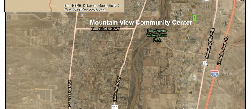
OSHA        Occupational Safety and          RPA       Registered Professional
            Health Administration                      Archaeologist
Pb          Lead                             SAAQS     State Ambient Air Quality
PCB         Polychlorinated Biphenyls                  Standards
PERCHA      Prescribed Endemic Refuge        SHPO      State Historic Preservation
            Connected Habitat Area                     Officer
PL          Public Law                       SO2       Sulfur Dioxide
PM10        Particulate Matter equal to or   SWQB      Surface Water Quality
            less than 10 microns in                    Bureau
            diameter                         TCP       Traditional Cultural Property
PM2.5       Particulate Matter equal to or   U.S.      United States
            less than 2.5 microns in         USACE     United States Army Corps of
            diameter                                   Engineers
PROS Plan   Bernalillo County Parks,         USC       United States Code
            Recreation and Open Space        USDA      United States Department of
            Facilities Master Plan                     Agriculture
RCCC        Recuerda a Cesar Chavez          USEPA     United States Environmental
            Committee                                  Protection Agency
REACH       Racial and Ethnic                Service   United States Fish and
            Approaches to Community                    Wildlife Service
            Health                           USGS      United States Geological
RMP         Rocky Mountain Population                  Survey
            of Greater Sandhill Cranes       VOCs      Volatile Organic Compounds
RMYC        Rocky Mountain Youth             WHA       Wildlife Hazard Assessment
            Corps

                                                                                   v
Draft Environmental Assessment for Prescribed Endemic
Refuge Connected Habitat Areas Project
1. PURPOSE AND NEED FOR THE PROJECT
   1.1. Introduction
The U.S. Fish and Wildlife Service (Service), Valle de Oro National Wildlife Refuge (NWR) in
cooperation with Bernalillo County (County) has prepared this Draft Environmental Assessment
(DEA) to analyze potential effects to physical, biological, and cultural resources and
socioeconomic conditions that may result from implementing the Proposed Action. This EA will
be used by the Service to decide whether or not to fund the proposed projects, or if further
analyses are needed through preparation of an environmental impact statement. If the Proposed
Action is selected as described or with minimal changes and no further environmental analyses
are needed, a Finding of No Significant Impact will be prepared.
The collaboration is being funded and supported by the County and Valle de Oro NWR through
a cooperative agreement between the agencies, the Service through the Five Star and Urban
Waters Restoration Program of the National Fish and Wildlife Foundation (NFWF); the State
Forestry Division of the New Mexico Energy, Minerals and Natural Resources Department; and
the Friends of Valle de Oro NWR. Since Federal funds are involved, the proposal is subject to
the National Environmental Policy (NEPA) provisions to analyze potential environmental effects
that may result from the Proposed Action. This DEA has been prepared pursuant to the
requirements of NEPA in accordance with Council on Environmental Quality regulations (40
CFR 1500-1509) and Department of the Interior (43 CFR 46; 516 DM 8) and U.S. Fish and
Wildlife Service (550 FW 3) regulations and policies. This DEA also incorporates other Federal,
State, and local environmental policies and regulations.
   1.2. Proposed Action
The South Valley Wellness Ecosystem, or Prescribed Endemic Refuge Connected Habitat Areas
(PERCHAs) project (Proposed Action), is a collaboration between the United States Fish and
Wildlife Service (Service), Valle de Oro NWR, and Bernalillo County (County), New Mexico, to
develop habitat areas on County properties within County-owned and -maintained drainage
facilities in the Albuquerque South Valley. The Valle de Oro NWR and Bernalillo County have
prepared the PERCHAs Plan (Plan) describing proposed habitat improvements on County
properties and how these areas will be utilized for educational and recreational activities,
improved access to health services, and workforce training. The Plan is attached to this document
(Appendix A) to provide more details regarding the Proposed Action.
Under the Proposed Action as described in the Plan, the County and Valle de Oro NWR will
work together to establish forage and habitat areas for wildlife with the goal of linking County
properties in the Albuquerque South Valley with the Valle de Oro NWR so that the PERCHAs
are viewed as one whole system of habitat areas. The County has developed the Plan to
“connect” the properties through enhancement of wetted habitat and vegetative species on the
properties, and relating them back to the Valle de Oro NWR interpretively. Proposed
improvements include enhancements to open areas and stormwater drain outfall areas on the
properties to provide hydrophytic vegetation where possible, replace non-native with native
vegetation, and install interpretive displays. The long-term vision for the Proposed Action is to
create a distributed network of wildlife habitat areas throughout the Rio Grande Valley in

                                                                                                    1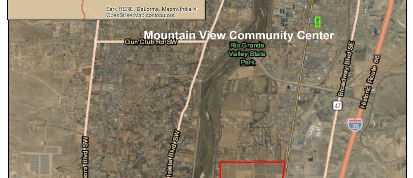
Bernalillo County that are connected by ditches maintained by the County’s Public Works
Division, Middle Rio Grande Conservancy District (MRGCD), and Albuquerque Metropolitan
Arroyo Flood Control Authority (AMAFCA).
The initial pilot project facilities and future projects are on lands owned by Bernalillo County
under the Parks and Recreation, Open Space, and Public Works Departments management in the
Albuquerque South Valley. There are approximately 15 PERCHA properties in total, with more
properties being added. This DEA focuses on four initial properties: the Los Padillas, McEwen
Pond, Mountain View, and Sanchez Farm properties (see Figure 1-1).

                                                                                               2
Figure 1-1. Overview Map of PERCHAs Project.

                                               3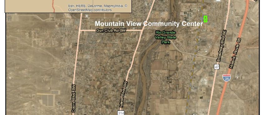
1.3. Project Background
The Valle de Oro NWR was established pursuant to 78 FR 35640. The primary purpose of the
refuge is to serve as an urban NWR, a distinction shared by only a handful of refuges nationwide
and the first for the southwestern region of the Service. This refuge provides easy access and key
outdoor recreation opportunities to more than 150,000 students and nearly two-thirds of the
entire State population and a new stop on the nationally recognized Paseo del Bosque recreation
trail. This refuge strongly emphasizes recreation and outdoor education and employment for
urban youth. It also serves as a gateway to other outdoor venues in the area, as well as to other
refuges within the State. The Proposed Action is the result of close cooperation with Bernalillo
County, the Trust for Public Lands, and many other partners, as well as extensive public
involvement.
The Proposed Action will develop habitat areas on County properties to complement the
developments and upgrades to the properties described in the Bernalillo County Parks,
Recreation and Open Space Facilities Master Plan (PROS Plan) (County 2015). The PROS Plan
describes the development of parks, recreation, and Open Space facilities in the next 15 years
and was adopted by the Bernalillo County Commission in October 2015. The PROS Plan
broadens the County’s parks and recreation mission to focus on improving quality of life by
emphasizing community health, cultural heritage, and economic development. Priorities include
green infrastructure improvements, environmental education programs, increased access to
recreation, and agricultural land conservation. The County PROS Plan calls for development of
agricultural and citizen science properties and programs to implement the goals of the plan
(County 2015).
   1.4. Purpose and Need for the Proposed Action
The purpose of this Proposed Action is to develop habitat areas on County properties within
County-owned and -maintained drainage facilities with the goal of linking County properties in
the Albuquerque South Valley with the Valle de Oro NWR to create one whole system of habitat
areas. The collaboration is being funded and supported by the County and Valle de Oro NWR
through a cooperative agreement between the agencies, the Service through the Five Star and
Urban Waters Restoration Program of the National Fish and Wildlife Foundation (NFWF); the
State Forestry Division of the New Mexico Energy, Minerals and Natural Resources
Department; and the Friends of Valle de Oro NWR.
The Albuquerque South Valley has experienced loss and degradation of riparian habitat and is a
low-income region that lacks access to health resources. The Proposed Action addresses
environmental and socioeconomic needs by improving stormwater quality and providing urban
habitat. This will help to reduce habitat loss and negative impacts to wildlife while increasing
human access to recreation, nutrition resources, health facilities, educational opportunities,
employment, and workforce training through creation and utilization of these habitat areas. By
providing these services, the Proposed Action also contributes to meeting the goals and policies
of both the County and Valle de Oro NWR, funding and cooperating agencies, and land
management agencies in the Albuquerque South Valley.

                                                                                                   4
1.5. Other Applicable Statues, Executive Orders, and Regulations
This DEA was prepared in compliance with all applicable Federal statutes, regulations and
Executive Orders as amended, including the following:
STATUTES, EXECUTIVE ORDERS, AND REGULATIONS
Cultural Resources Scoping letters offering consultation were mailed
in March 2019 (see Appendix C) and no negative
American Indian Religious Freedom Act, as amended, 42
comments were received during tribal
U.S.C. 1996 – 1996a; 43 CFR Part 7
consultation (see Appendix D). The findings of
Antiquities Act of 1906, 16 U.S.C. 431-433; 43 CFR Part 3 the cultural resources investigation were
submitted to the SHPO. Carrie J. Gregory, M.A.,
Archaeological Resources Protection Act of 1979, 16 U.S.C.
RPA, of Statistical Research Inc., met with Dr.
470aa – 470mm; 18 CFR Part 1312; 32 CFR Part 229; 36 Cunnar, the assigned SHPO reviewer, on April
CFR Part 296; 43 CFR Part 7 16, 2019 to discuss the Proposed Action. The
National Historic Preservation Act of 1966, as amended, 16 office of the SHPO concurred with the
U.S.C. 470-470x-6; 36 CFR Parts 60, 63, 78, 79, 800, 801, recommendation that there are no NRHP-eligible
and 810 resources on the Proposed Action properties. The
Proposed Action would result in “No Historic
Paleontological Resources Protection Act, 16 U.S.C. 470aaa Properties Affected” because there are no NRHP
– 470aaa-11 eligible sites within the APE. A request for
Native American Graves Protection and Repatriation Act, 25 concurrence was sent to the SHPO on April 12,
U.S.C. 3001-3013; 43 CFR Part 10 2019 (Appendix E).
Executive Order 11593 – Protection and Enhancement of the
Cultural Environment, 36 Fed. Reg. 8921 (1971)
Executive Order 13007 – Indian Sacred Sites, 61 Fed. Reg.
26771 (1996)
Fish & Wildlife
Bald and Golden Eagle Protection Act, as amended, 16
U.S.C. 668-668c, 50 CFR 22
Endangered Species Act of 1973, as amended, 16 U.S.C.
1531-1544; 36 CFR Part 13; 50 CFR Parts 10, 17, 23, 81,
217, 222, 225, 402, and 450
Fish and Wildlife Act of 1956, 16 U.S.C. 742 a-m
Lacey Act, as amended, 16 U.S.C. 3371 et seq.; 15 CFR
Parts 10, 11, 12, 14, 300, and 904
Migratory Bird Treaty Act, as amended, 16 U.S.C. 703-712;
50 CFR Parts 10, 12, 20, and 21
Executive Order 13186 – Responsibilities of Federal
Agencies to Protect Migratory Birds, 66 Fed. Reg. 3853
(2001)
Natural Resources
Clean Air Act, as amended, 42 U.S.C. 7401-7671q; 40 CFR
Parts 23, 50, 51, 52, 58, 60, 61, 82, and 93; 48 CFR Part 23
Wilderness Act, 16 U.S.C. 1131 et seq.
Wild and Scenic Rivers Act, 16 U.S.C. 1271 et seq.
5Executive Order 13112 – Invasive Species, 64 Fed. Reg.
6183 (1999)
Water Resources
Coastal Zone Management Act of 1972, 16 U.S.C.
1451 et seq.; 15 CFR Parts 923, 930, 933
Federal Water Pollution Control Act of 1972 (commonly
referred to as Clean Water Act), 33 U.S.C. 1251 et seq.; 33
CFR Parts 320-330; 40 CFR Parts 110, 112, 116, 117, 230-
232, 323, and 328
Rivers and Harbors Act of 1899, as amended, 33 U.S.C. 401
et seq.; 33 CFR Parts 114, 115, 116, 321, 322, and 333
Safe Drinking Water Act of 1974, 42 U.S.C. 300f et seq.; 40
CFR Parts 141-148
Executive Order 11988 – Floodplain Management, 42 Fed.
Reg. 26951 (1977)
Executive Order 11990 – Protection of Wetlands, 42 Fed.
Reg. 26961 (1977)
1.6. Public Outreach
The Bernalillo County Parks and Recreation Department conducted the planning effort for the
projects outlined in the PROS Plan, beginning in the fall of 2013 with planning workshops at
Paradise Hills and Westside community centers. Since that time, the Department has held more
than 40 public meetings and workshops throughout the County. Community engagement
activities have included communitywide surveys and gathering input from several other
institutional and municipal stakeholders, including AMAFCA, MRGCD, and the City of
Albuquerque.
Planning studies were also developed from the community planning processes. The result was
the development of plans for the future of the County’s system of parks, recreation, and Open
Space facilities in groups based on their geographic location, or “Neighborhood Community
Area.” The Neighborhood Community Area Plan documents and the community planning
process were summarized in the draft PROS Plan, which was further developed through
feedback from commissioners, staff, and key stakeholder agencies, then distributed for public
review and comment. The final PROS Plan (October 2015) lists and prioritizes future capital
projects to be funded, planned, designed, and constructed. All future development of parks,
recreation, and Open Space facilities will be contingent upon funding and subject to the approval
of the Bernalillo County Commission. Prioritization of these projects was based on numerous
factors, including existing facilities and needs assessments, level of service analyses, and
community health analyses to identify and prioritize projects in vulnerable community areas
(County 2015).
The Proposed Action is designed to complement a subset of the projects outlined in the PROS
Plan by creating plans for additional habitat improvements. Public meetings for the Proposed
Action were held on August 2, 2018, and November 1, 2018, at the Mountain View Community
Center, and a third meeting occurred on January 21, 2019, at the McEwen Pond property.
6Scoping letters were sent to the sources above on March 3 and 9, 2019 and April 1, 2019
(Appendix C). Responses to scoping letters are in Appendix D.
A public meeting will be held during 30-day public review of the DEA.
2. ALTERNATIVES CONSIDERED
2.1. No Action Alternative
Under the No Action Alternative forage and habitat areas for wildlife, on County properties
within County-owned and -maintained drainage facilities, would not be created under the
proposed funding source. The existing properties and vegetation within those properties would
remain the same. Current land use and operations would continue. Without implementation of
the Proposed Action, the proposed funding source would not be used to improve native
vegetation and drainage facilities which would improve stormwater quality and reduce habitat
loss and negative impacts to wildlife. Human access to recreation, nutrition resources, health
facilities, educational opportunities, employment, and workforce training would not be improved
on these properties with the proposed funding source.
2.2. Proposed Action
This DEA focuses on four initial properties: Los Padillas, McEwen Pond, Mountain View, and
Sanchez Farm Open Space (see Figure 2-1). Under the Proposed Action as described in the Plan
(Appendix A), the County and Valle de Oro NWR will work together to establish forage and
habitat areas for wildlife with the goal of interpretively linking County properties in the
Albuquerque South Valley with the Valle de Oro NWR.
Stormwater and Creation of Wildlife Habitat
Each PERCHAs property plan incorporates measures to establish or expand urban habitat on the
property to benefit native wildlife species by providing cover, foraging, and possibly nesting
structure. Each plan includes measures to improve the quality and infiltration of the stormwater
entering the property’s stormwater drainage facilities. Stormwater can be used to enhance habitat
beneficial for wildlife in stormwater retention areas. These stormwater retention areas and the
vegetation they support can also improve stormwater quality.
Where water availability is sufficient, perennial or ephemeral wetted habitat will be enhanced
with native plantings; where water is less available, native upland habitat will be established,
with each habitat type benefiting different migratory bird species. New wetlands and large
waterfowl habitat will not be created, only existing runoff will be utilized, and property features
will be enhanced with native plantings. The stormwater detention areas are designed to meet the
96-hour rule which states that all detention ponds must drain stormwater within 96 hours or less
(19.26.2.15 NMAC). Additionally, each plan incorporates habitat enhancements that use plants
beneficial to pollinator species.
To develop habitat areas on County properties within County-owned and -maintained drainage
facilities the following actions would be performed:
At the Los Padillas Community Center, approximately eight acres of habitat improvements
would include removing the nonnative and invasive vegetation growing in the northern drainage
pond and throughout the property, and replacement of the cobbles lining the drainage swales
surrounding the parking lot with native upland grass species and pollinator plants (Figure 2-1 and
7Figure 5-2 of the Plan, Appendix A). Vegetation would be removed by hand using chainsaws.
Material would be piled and chipped on site or hauled off.
At the Mountain View Community Center, approximately five acres of habitat improvements
would include removing the nonnative and invasive vegetation growing in the southwestern
drainage basin. Improvements would also include removal of the cobbles lining the drainage
swale adjacent to the parking lot in the southeast corner of the property and replacement with
native upland grass species and pollinator plant species. Cobbles would also be removed from
the swales in the northeastern section of the property and the swales used to develop low-stature
upland vegetation so that the function of the air quality station in the northeastern section of the
property is not obscured (Figure 2-1 and Figure 5-4 of the Plan, Appendix A).
At McEwen Pond, approximately two acres of improvements would include the addition of
native habitat in the stormwater basin and a small orchard and edible shrubs to provide songbird
and pollinator habitat as well as an appealing recreation space for residents. Pollinator habitat
areas will also be installed as part of the overall habitat construction (Figure 1-2 and Figure 5-3
of the Plan, Appendix A).
At Sanchez Farm Open Space, approximately 14 acres of improvements are planned to further
implement the Site Enhancement Master Plan (Figure 2-1 and Figure 5-5 of the Plan, Appendix
A) which includes habitat restoration of the slopes of the stormwater basin. The activities would
include cottonwood (Populus deltoides) plantings at the bottom of the slopes and New Mexico
olive (Forestiera neomexicana) on the tops of the slopes, revegetation of eroded slopes with
native grasses and shrubs and erosion control measures such as mulch blankets, straw wattles, or
earth forms (e.g., bunds or swales running perpendicular to the slope) to slow and collect water.
Additionally, pollinator plants would be incorporated. Nonnative and invasive vegetation
removal and treatment would be implemented throughout the property. The lowland agricultural
fields would be planted with saltgrass and other species suited to higher salinities.
Interpretive Displays
Each property will include interpretive displays that include connections to Valle de Oro NWR,
with a unifying symbol for PERCHAs properties. The displays will explain the value of wildlife
and urban habitat, stormwater quality, the relationship between water quality and habitat
conservation, and the importance of environmental conservation.
Connecting People to Nature and Improving Environmental Awareness
Each created habitat area will include trails, bridges, and/or overlook areas with access that
complies with the Americans with Disabilities Act (ADA) to enable all visitors to access these
areas and view the plants and animals associated with the habitat. The displays will also inform
visitors of the other PERCHAs properties, their location and relationship to each other, and how
to visit them. Interpretive signs will introduce plant and animal species visitors might find at the
property and at the Valle de Oro NWR, including endangered species in the Rio Grande of the
South Valley of Albuquerque. The signs will explain the importance of protecting and recovering
priority species and habitats and promoting stewardship of native habitat.
Education
In addition to interpretive displays about the South Valley Wellness Ecosystem, the species
associated with the ecosystem, and the need for conservation, each property plan includes an
outdoor classroom area with seating to facilitate the use of the property as well as the created
8native habitat as an environmental education opportunity. On properties where farming or
community gardens are feasible, agricultural demonstrations and training will be available. The
outdoor classroom area will create a gathering space for students from local schools, youth
groups, youth corps, and other local programs. The PERCHAs properties also will provide
volunteer opportunities for groups to get involved in maintaining and improving these properties.
Recreation
In addition to creating native habitat areas and opportunities for wildlife viewing, each plan
includes Prescription (Rx) Trails and future plans to connect the properties through trails. The
plans for some properties also include upgrades to or the addition of playground equipment.
Shade structures and shade trees are included in each plan to encourage the use of the properties
and to make the properties more appealing to visitors. Additionally, the installation of benches is
incorporated into each plan to allow wildlife observation, provide a place for visitors to rest, and
provide the opportunity for individuals with all levels of mobility to enjoy the space.
Employment and Workforce Training
On properties where farming or community gardens are feasible, these spaces will be used for
agricultural demonstrations and training. RMYC (Corps) and SCC will hire and train young
adults to implement the projects in partnership with other volunteers and partners. Some Corps
members will be recruited from the South Valley to encourage a sense of stewardship and pride
in the project. Corps members will be provided paid community service opportunities and
workforce development training, while developing educational and social skills and gaining an
ethic of natural resource stewardship. Their experience will increase their capacity to gain
employment and further their education. Additionally, RMYC offers the Naturalist Apprentice
program for crew members to gain an increased awareness of and respect for the natural
environment and opportunities to earn educational scholarships for their service (RMYC 2018b).
Increased Access to High-Quality Food
Each PERCHAs property will provide a space for food vendors such as farmer’s markets to
provide services. Additionally, the PERCHAs property plans include locations for community
gardens and larger farming activities where the space is sufficient.
The Valle de Oro NWR and Bernalillo County have prepared the PERCHAs Plan (Plan) and the
Plan is attached to this document (Appendix A) to provide more details regarding the Proposed
Action.
9Figure 2-1. Overview of PERCHAs Property Habitat Improvements
103. AFFECTED ENVIRONMENT AND ENVIRONMENTAL CONSEQUENCES
The Action Area for the Proposed Action is located on four PERCHAs project properties: Los
Padillas, McEwen Pond, Mountain View, and Sanchez Farm Open Space properties. The
PERCHAs properties range from two to 14 acres and are within approximately five miles of the
Valle de Oro NWR. The PERCHAs properties are in commercial, residential, and semi-rural
agricultural areas within a mile of the Rio Grande and the Rio Grande riparian ecosystem, or
“bosque,” and would have been in the Rio Grande floodplain prior to development in the
Albuquerque area.
The city of Albuquerque’s South Valley in Bernalillo County, New Mexico encompasses the
PERCHAs properties, the Valle de Oro NWR, and a portion of the Rio Grande and its associated
bosque and is considered the Affected Environment.
This section describes the existing environmental and socioeconomic settings in the Affected
Environment and analyzes the environmental consequences of the Proposed Action on each
affected resource, including direct and indirect effects. Impact types are defined as the following:
• Direct effects are those which are caused by the action and occur at the same time and
place.
• Indirect effects are those which are caused by the action and are later in time or farther
removed in distance but are still reasonably foreseeable.
• Cumulative impacts result from the incremental impact of the action when added to other
past, present, and reasonably foreseeable future actions regardless of what agency
(Federal or non-Federal) or person undertakes such other actions.
3.1. Geology & Soils
Existing Conditions
The Albuquerque South Valley, New Mexico lies along the Rio Grande, which originates in
Colorado and flows south 1,640 miles to the Gulf of Mexico. The elevation of the riverbed just
west of downtown Albuquerque is 4,900 feet above sea level. The MRG Basin is one of a series
of basins formed during the extension of the Rio Grande Rift and is approximately 3,000 square
miles. There are several regional faults intersecting the area. The basin is primarily filled with
poorly consolidated sediments that have eroded from the surrounding mountains. The upper part
of the basin fill is comprised of a sequence of gravel, sand, silt, clay, and caliche deposits of the
middle Pleistocene to uppermost Miocene Upper Santa Fe Group and post-Santa Fe Group
deposits. These units include alluvial fan, fluvial, eolian, playa, colluvial, and floodplain deposits.
The Rio Grande graben contains several thousand feet of poorly consolidated, basin-fill
sediments of the Santa Fe Group of middle Miocene to Pleistocene age (USDA 1977). Water
tables in the floodplain are typically four to twelve feet deep and permeability is moderate
(Bowman 2002). Depth to ground water increases greatly with distance from the river.
West of the river floodplain, approximately 8 to 12 miles from downtown Albuquerque, the land
rises through low bluffs and gradual slopes to a high mesa 5,600 to 6,000 feet in elevation. On
the east side of the Rio Grande, the land between the Albuquerque International Airport and
Interstate 40 rises to the East Mesa, 5,100 to 5,300 feet in altitude. North of Interstate 40, the
high, flat mesa disappears and, instead, the ground gradually slopes upward from the river
bottom for nearly eight miles to the foot of the Sandia Mountains, elevation 6,000 feet. The
highest point on the Sandia Mountains is Sandia Crest, elevation 10,678 feet.
11The Albuquerque South Valley is in the Arizona and New Mexico Mountains Major Land
Resource Area (MLRA) within the greater Western Range and Irrigated Region Land Resource
Region (LRR). The soils in this MLRA are dominantly Aridisols, Entisols, and Mollisols. The
dominant suborders are Argids and Calcids on plains and in basins; Orthents on plains, on
plateaus, and in valleys throughout the region; and Xerolls and Ustolls on mountain slopes. The
soils in the region dominantly have a mesic soil temperature regime, an aridic soil moisture
regime, and mixed mineralogy. (USDA-NRCS 2006).
A Natural Resources Conservation Service (NRCS) Soil Survey Geographic Database custom
soil report was generated to analyze soil characteristics within the Action Area. A detailed
description of soils can be found within the Custom Soil Resource Report Bernalillo County
(USDA-NRCS 2019). Within the valley the most common soils are the Vinton sandy loam, 0 to
1 percent slopes; Torrifluvents, frequently flooded; and Glendale clay loam, 0 to 1 percent slopes
which are all typical of floodplains and derived from recent alluvium from igneous and
sedimentary rock. Outside of the floodplain the most common soils in the Albuquerque South
Valley are the Bluepoint loamy fine sand, 1 to 9 percent slopes and the Bluepoint-Kokan
association which are derived from sandy alluvium and /or eolian sands.
The Farmland Protection Policy Act is intended to minimize the adverse effects of Federal
programs on farmland that might contribute to the unnecessary and irreversible conversion of
important farmland to nonagricultural uses; and assure that Federal programs are operated in a
manner that, will be compatible with State, local government, and private programs that protect
farmland. No soils identified in the custom soil report are prime farmland (USDA-NRCS 2019).
Effects on Geology & Soils
No Action Alternative
There would be no change to geology and soils under the No Action Alternative.
Proposed Action
No major removal of soils will occur under the Proposed Action. The Proposed Action would
decrease erosion through establishing a native plant community in stormwater retention areas
and improve the capture and infiltration of stormwater. There would be a short-term disturbance
to soils during removal of non-native vegetation and in areas where small machinery will be
used. This would be during implementation only. Soils will be compacted around planted areas
so that no erosion will occur. Plant establishment, especially along the banks of the stormwater
facilities, will also aid in reducing erosion. The Proposed Action would have no effect on
geology and a positive effect on soils.
3.2. Vegetation (including vegetation of special management concern)
Existing Conditions
The Albuquerque South Valley lies within the Plains and Great Basin grassland biotic
community (Brown 1982). This area is characterized by upland grasslands and riparian bosque in
the lowland closer to the Rio Grande. The dominant plant community on the West Mesa is Great
Basin grassland. This plant community is mainly grasses mixed with some shrubs and annual
plants. The dominant grass is black grama (Bouteloua eriopoda). Less abundant are sand
dropseed (Sporobolus cryptandrus), mesa dropseed (Sporobolus flexuosus), galleta (Pleuraphis
jamesii), three-awn (Aristida purpurea), blue grama (Bouteloua gracilis), alkali sacaton
12(Sporobolus airoides), bush muhly (Muhlenbergia porteri), and Indian ricegrass (Achnatherum
hymenoides). Apache plume (Fallugia paradoxa) is the most common shrub. Broom snakeweed
(Gutierrezia sarothrae, broom dalea (Psorothamnus scoparius, prickly pear cactus (Opuntia
spp.), soapweed yucca (Yucca glauca), cholla cactus (Cylindropuntia spp.), winterfat
(Krascheninnikovia lanata), and catclaw mimosa (Mimosa aculeaticarpa) also occur. Annual
plants, which increase in years of above-average precipitation, are tansy mustard (Descurainia
spp.), Indian paintbrush (Castilleja Mutis), wooly Indian-wheat (Plantago patagonica),
lambsquarters (Chenopodium album), Russian thistle (Salsola spp. ), and bladderpod
(Lesquerella spp.). If this plant community is disturbed, annual plants increase. Sand dropseed
becomes prominent and cactus, and broom snakeweed increase significantly. Disturbance is also
evident by dense stands of Russian thistle and burning bush (Kochia scoparia). Over time, urban
development and encroachment have disturbed and degraded the native vegetation in and around
Albuquerque.
In 1981 and 1982, Hink and Ohmart (1984) conducted a study of 163 miles of riparian habitat in
the Upper and MRG between Española and San Acacia, New Mexico, describing in detail, plant
communities and associated fauna. The MRG riparian woodland (bosque) represents the largest
cottonwood riparian forest in the southwestern United States. This reach of the MRG extends
from Cochiti Dam downstream 160 miles to San Marcial, New Mexico. Albuquerque is located
near the center of this reach. The Rio Grande is regulated for water supply (primarily irrigation)
and flood control, and that regulation has contributed to the present character of the riparian
ecosystem.
On the valley floor, much of the grassland, wetland, and riparian vegetation has been converted
to cultivated cropland through irrigation. Fallow fields and irrigation ditches are major features.
In general, the Albuquerque South Valley is characterized as semi-urban consisting of
commercial development along the major traffic arteries and private residences on large lots
along the secondary and residential roadways. Most of the open land has been cleared around the
residences for use as yards or for agriculture and livestock.
EO 13112 (as amended), Invasive Species, requires Federal agencies to identify actions that
could affect the status of invasive species and prevent the introduction of invasive species. It also
requires Federal agencies to not authorize, fund, or carry out actions likely to cause or promote
the introduction or spread of invasive species in the United States. A list of potentially-occurring
noxious weeds in the Action Area was prepared using applicable State and County weed lists.
The State of New Mexico, under the administration of the New Mexico Department of
Agriculture (NMDA), lists certain weed species as noxious (NMDA 2016). “Noxious” in this
context refers to plants that are not native to New Mexico, that are targeted for management and
control, and that have a negative impact on the economy or the environment. Class C listed
weeds are common, widespread species that are well established in the State; Class B weeds are
considered common but are not yet widespread in certain regions of the State; and Class A weeds
have limited or no distribution in the State. Preventing new infestations of Class A species and
eradicating their infestations is the highest priority. Class B species are found in limited portions
of the State. In severe infestation areas, containing infestation and stopping further spreading is
the management goal. Class C species are widespread in the State, and their management
decisions are determined at the local level, based on feasibility of control and infestation level.
Non-native and/or invasive vegetation species observed in the Action Area are listed in Table 3-
1.
13Table 3-1. Non-native and/or Invasive Vegetation Species in Action Area
Common Name Scientific Name Weed Classification
Tamarix ramosissima and Tamarix
Saltcedar chinensis Class C
Bermuda grass Cynodon dactylon Class C in California
Russian olive Elaeagnus angustifolia Class C
Siberian elm Ulmus pumila Class C
Burning bush Bassia scoparia or Kochia scoparia Class B in Oregon and Washington
Russian thistle Salsola spp. Class C in California, Noxious in Arkansas
Tree of heaven Ailanthus altissima Class C
Johnson grass Sorghum halepense Various designations in 19 other states
Various designations in 13 other states, U.S.
Dodder Cuscuta spp. noxious weed
Spiny cocklebur Xanthium spinosum Class B
American common reed Phragmites australis Vario
Field bindweed Convolvulus arvensis Various designations in 6 other states
Alfalfa Medicago sativa Various designations in 22 other states
Cheatgrass Bromus tectorum None
Class C
Effects on Vegetation (including vegetation of special management concern)
No Action Alternative
There would be no change to vegetation under the No Action Alternative. The presence of non-
native and invasive vegetation on Proposed Action PERCHAs project properties would not be
removed and potentially increase, further decreasing habitat value and threatening the existence
of native plant communities.
Proposed Action
The Proposed Action proposes to remove non-native and invasive vegetation species while
restoring native vegetation to improve habitat for native wildlife species. With proper disposal of
non-native and invasive vegetation species that have been removed from project properties and
cleaning of equipment used to remove vegetation, the Proposed Action will not contribute to the
spread of vegetation of special management concern. This will allow native vegetation and
associated wildlife to inhabit the area. Removal of invasive species will reduce the amount of
non-native vegetation growing in the area which provides little habitat value and threatens the
existence of native vegetation species. The Proposed Action would promote the establishment
and growth of native vegetation and would therefore have a beneficial effect on native
vegetation.
3.3. Wildlife and Aquatic Species
Existing Conditions
The Albuquerque South Valley is an area of mixed land use comprised of industrial, commercial,
residential, and semi-rural agricultural areas, while portions of the Rio Grande bosque and
14upland grasslands and shrublands in the South Valley have remained undeveloped. Riparian and
wetland areas along the Rio Grande in the Albuquerque South Valley are valuable resources for
wildlife and plants, especially considering the aridity of the Albuquerque area. Fresh-water
ecosystems support more species and a greater diversity of species than other ecosystems while
comprising only 0.01% of the world's water and 0.8% of the Earth’s surface (Dudgeon et al.
2006). At least 80 percent of vertebrate wildlife occurring in New Mexico use riparian areas at
some stage of their lives and 50 percent are permanent residents (NMDGF 2004). Riparian areas
support a greater diversity of breeding birds than all other habitats in the State combined. In
addition, the Middle Rio Grande (MRG) Valley, which encompasses the river from Cochiti Dam
to San Marcial, New Mexico, is a critical travel corridor for migrating birds connecting Central
and South America to North America along the Rio Grande Flyway (Yong and Finch 2002).
Upland areas also provide habitat for many wildlife species and are important to watersheds and
the health and function of riparian and wetland habitats. Uplands provide buffers to those
habitats by capturing runoff and sediment and associated chemical pollutants, therefore
improving the quality of water that enters wetlands and rivers (Trenham and Shaffer 2005).
Both the riparian and wetland areas along the Rio Grande in the Albuquerque South Valley and
the associated uplands have been degraded by anthropogenic activities. The bosque within the
Albuquerque South Valley has declined in both habitat area and habitat quality as the result of an
increasing human population and water use, contaminants discharged to the river, land
development, and flood control. Flood control, drainage, and agriculture in the MRG Valley
have contributed to the loss of approximately 85% of wetlands from the mid-1930s to the mid-
1990s (Linderoth 1999). Upland areas have also been degraded by the introduction of invasive
species, climate change, and the mismanagement of livestock and grazing, changing the plant
composition and productivity of these ecosystems (Dick-Peddie 1993). The degraded ecosystem,
disconnected habitat, and land development impede access to the bosque for recreation and can
negatively influence human health. Because of the continually increasing human population and
associated impacts to the Rio Grande bosque ecosystem as a whole, collaborative and creative
restoration is necessary to preserve the bosque, improve ecosystem function, and improve access
to nature and recreation in the bosque, which ultimately benefits human health.
The PERCHAs properties vary in the wildlife species they support. Some properties support very
few wildlife species whereas other properties such as Sanchez Farm Open Space provide more
habitat for wildlife species. A limited number of bird, insect, bat, and, on some properties,
amphibian species occur on the PERCHAs properties. Wildlife use extends between the
PERCHAs properties, including Valle do Oro NWR, with ties to the Rio Grande, and species
that inhabit the river and its bosque.
Wildlife species are more likely to occur on properties closer to riparian areas and undeveloped
upland areas. The PERCHAs properties currently are only likely to be temporarily visited by
most wildlife and not likely to provide nesting or breeding habitat for avian species. The fauna
likely to occur in the Albuquerque South Valley and that may occur on the PERCHAs properties
are briefly discussed below. A species list is included in Appendix B:
Birds. Birds represent the largest and most diverse group. Bird species composition, diversity,
and abundance in the Albuquerque South Valley have changed as a result of habitat changes and
human activity. Surveys conducted in the Rio Grande bosque in 1981 and 1982 documented 277
species of birds (Hink and Ohmart 1984), and Thompson et al. (1994) observed 259 avian
15species in 1992 and 1993. About one-third of these species occupy the MRG Valley only during
annual migrations between their breeding and wintering grounds (Finch et al. 1995).
Fish. Along the length of the Rio Grande within New Mexico, 27 native fish species and 33 non-
native species are documented (Sublette et al. 1990). Coldwater species are prevalent in the
upper reach (upstream of Cochiti Lake) and warm water species occur near Elephant Butte
Reservoir. The fish that occur in the Rio Grande in the Albuquerque South Valley are a mixture
of warm and coldwater species. The only fish occurring on any of the PERCHAs properties is
the western mosquito fish, which was introduced into the ponds at Sanchez Farm Open Space for
mosquito control. The other properties do not provide perennial sources of water for fish.
Reptiles and amphibians. Fifty-seven reptile species may occur in the MRG Valley (Degenhardt
et al. 1996) and 13 amphibian species are likely to occur in the MRG Valley. Habitats that lack
dense canopy cover and that were characterized by sandy soils and sparse ground cover had the
greatest abundance and diversity (Hink and Ohmart 1984).
Mammals. Eleven species of bats are found along the Rio Grande (Findley et al. 1975). Other
mammals likely to occur are various species of rodents and occasionally small carnivores such as
skunks and coyotes.
Effects on Wildlife and Aquatic Species
No Action Alternative
There would be no change to wildlife and aquatic species under the No Action Alternative.
Federal funds would not be used to create habitat or improve stormwater quality that could
benefit wildlife.
Proposed Action
The Proposed Action is intended to increase native vegetation, and therefore wildlife habitat, and
improve stormwater quality by capturing and infiltrating stormwater and removing pollutants in
vegetated detention areas. This would have a beneficial effect on wildlife and aquatic species by
providing improved habitat and potentially corridors, or stopover habitat, between undeveloped
areas in the Albuquerque South Valley. Aquatic habitats in the valley receiving stormwater
runoff from the Action Area would benefit from the reduction in pollutants and sediment. There
would be short-term negative impacts to wildlife during implementation within the project areas
when non-native trees are removed and native vegetation is planted. Wildlife would return once
implementation is complete. Under the Proposed Action there would be a long-term beneficial
effect to wildlife and aquatic species.
3.4. Bird Aircraft Strike Hazard
Existing Conditions
Bird Aircraft Strike Hazard (BASH) is concerned with aircraft collisions with birds and other
wildlife. A Memorandum of Agreement (MOA) between the Federal Aviation Administration,
the U.S. Air Force, the U.S. Army, the U.S. Environmental Protection Agency, the Service, and
the U.S. Department of Agriculture to Address Aircraft-Wildlife Strikes was signed by Partners
in 2002 and 2003. The agreement was signed in reference to Advisory Circular (AC) 150/5200-
33 (1997). Criteria were developed for siting wildlife attractants for a distance of 5,000 feet for
airports serving piston-powered aircraft and 10,000 feet for airports serving turbine-powered
aircraft. A local MOU is in process between the Service/Valle de Oro, Albuquerque Sunport,
16You can also read