Transportation Chapter 13: Golf Lane SHD
←
→
Page content transcription
If your browser does not render page correctly, please read the page content below
Chapter 13:

Transportation
Golf Lane SHD
Environmental Impact Assessment Report                                                       Chapter 13 – Transportation

13.0 TRANSPORTATION

13.1      INTRODUCTION

This chapter has been produced to examine, assess and evaluate the likely impact of a proposed residential
development on the local transportation network, as well as identifying proposed mitigation measures to
minimise any identified impacts.

The proposed development comprises a residential development of 482 no. units (all apartments), along with
ancillary residential amenities, and provision of a childcare facility, gym, and local shop. The proposed
residential units comprise 31 no. studio units, 183 no. 1-bedroom units, 229 no. 2-bedroom units, and 39 no. 3-
bedroom units (including 2 no. duplex type units).

Two basement levels are proposed, providing car parking spaces (299 no.), bin stores, plant rooms, bicycle
parking (1,000 no. spaces), and circulation areas. A further 240 no. bicycle parking spaces and 4 no. car parking
spaces are provided at ground level.

The proposed development includes landscaping, boundary treatments, public, private and communal open
space (including roof terraces), two cycle / pedestrian crossings over the stream at the western side of the site,
along with a new pedestrian and cycle crossing of Glenamuck Road South at the west of the site, cycle and
pedestrian facilities, play facilities, and lighting. The proposed buildings include the provision of private open
space in the form of balconies and winter gardens to all elevations of the proposed buildings. The development
also includes vehicular, pedestrian, and cycle accesses, drop off areas, boundary treatments, services, and all
associated ancillary and site development works.

The purpose of this chapter is to quantify the existing transport environment and to detail the results of
assessment work undertaken to identify the potential level of any transport impact generated as a result of the
proposed residential development. The scope of the assessment covers transport and related sustainability
issues including means of vehicular access, pedestrians, cyclists and local public transport connections.

13.2      STUDY METHODOLOGY

The approach to the assessment of likely significant impacts on traffic and transportation in this chapter accords
with policy and guidance at EU, national and local level. Accordingly, the adopted methodology responds to
best practices, current and emerging guidance, exemplified by a series of publications, all of which advocate
this method of analysis. Key publications consulted include:

     •    “Guidance on the preparation of the Environmental Impact Assessment Report” (EC, 2017);
     •    Environmental Protection Agency (EPA) Guidelines on the information to be contained in the EIAR
          (2017);
    •     ‘Traffic and Transport Assessment Guidelines’ (May 2014) National Road Authority (now TII),
    •     ‘Traffic Management Guidelines’ Dublin Transportation Office & Department of the Environment and
          Local Government (May 2003);
    •     ‘Guidelines for Traffic Impact Assessments’ The Institution of Highways and Transportation;
    •     Dún Laoghaire Rathdown Council Development Plan 2016-2022;
    •     Ballyogan & Environs Local Area Plan 2019-2025;
    •     Review of the Glenamuck Local Area Plan – Traffic Modelling Report (June 2013) Dún Laoghaire
          Rathdown County Council and
    •     Cherrywood SDZ.

The methodology incorporated a number of key inter-related stages, including;

    •     Background Review: This important exercise incorporated three parallel tasks which included (a) an
          examination of the local regulatory and development management documentation; (b) an analysis of

                                                                                                   Chapter 13/ Page 1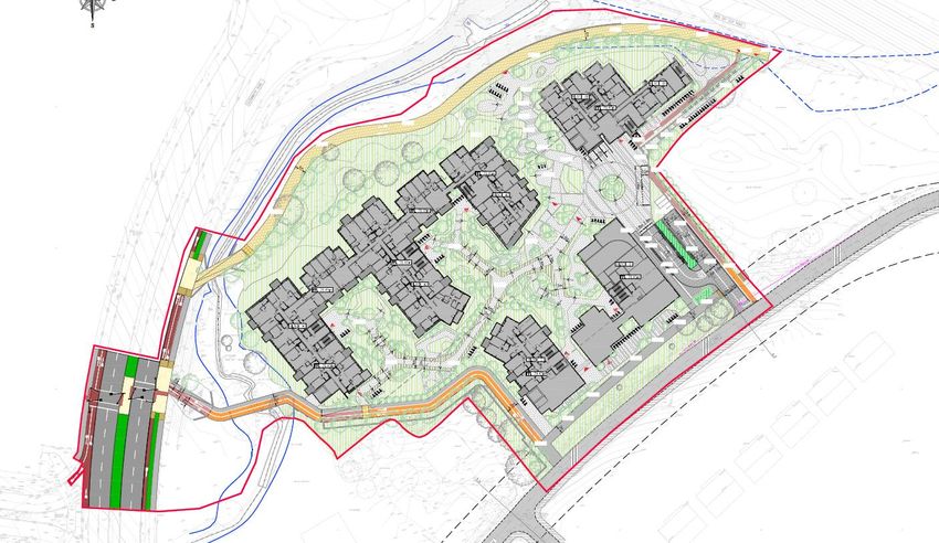
Golf Lane SHD
Environmental Impact Assessment Report                                                            Chapter 13 – Transportation

          previous ‘transport’ related, strategic and site specific studies of both development and transport
          infrastructure proposals across the Carrickmines area, and (c) a review of recent planning applications
          to establish the legal status of various third party development schemes which have emerged and
          received full planning permission since.

    •     Site Audit: A site audit was undertaken to quantify existing road network issues and identify local
          infrastructure characteristics, in addition to establishing the level of accessibility to the site in terms of
          walking, cycling and public transport. An inventory of the local road network was also developed during
          this stage of the assessment.

    •     Traffic Counts: Junction traffic counts in addition to vehicle queue length surveys were undertaken and
          analysed with the objective of establishing local traffic characteristics in the immediate area of the
          proposed residential development.

    •     Trip Generation: A trip generation exercise has been carried out to establish the potential level of
          vehicle trips generated by the proposed residential development.

    •     Trip Distribution: Based upon both the existing traffic characteristics, a distribution exercise has been
          undertaken to assign site generated vehicle trips across the local road network.

    •     Network Analysis: Further to quantifying the predicted impact of vehicle movements across the local
          road network for the adopted optimum site access strategy more detailed computer simulations have
          been undertaken to assess the operational performance of key junctions in the post development 2023,
          2028 and 2038 development scenarios.

13.3      EXISTING RECEIVING ENVIRONMENT

Land Use

The proposed development site is currently characterised as a brownfield site having previously accommodated
a number of private dwelling houses. The subject lands are zoned “Objective A – To protect and-or improve
residential amenity” within the Dún Laoghaire-Rathdown County Development Plan 2016-2022.

            Figure 13.1: Land-Use Zoning (Source: Google Maps/CDP)

                                                                                                        Chapter 13/ Page 2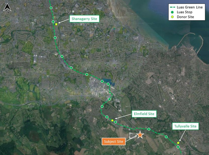
Golf Lane SHD
Environmental Impact Assessment Report                                                       Chapter 13 – Transportation

Furthermore, two recent planning applications have previously been submitted in respect of development
proposed on the subject lands (Planning Ref. D06A-1157 for 125 residential dwellings and Planning Ref. D08A-
0590 for 90 residential dwellings). The previously permitted planning permission for these two applications have
since lapsed.

Location

The site has an area of c. 2.56 hectares and is bound to the north by the M50 motorway, to the east by Golf
Lane, to the west by Glenamuck Road, and to the south by existing residential development.”. The development
fronts onto Golf Lane corridor which currently forms a cul de sac road used for access to existing local dwellings
along Golf Lane and Carrickmines Golf Course.

The general location of the subject site in relation to the surrounding road network is illustrated in Figure 13.2
below whilst Figure 13.3 indicatively shows the extent of the subject site lands.

                  Figure 13.2: Site Location (Source: Google Maps)

                  Figure 13.3: Indicative Site Boundary (Source: Google Maps)

                                                                                                   Chapter 13/ Page 3
Golf Lane SHD
Environmental Impact Assessment Report Chapter 13 – Transportation
The subject development site is situated approximately 15km south of Dublin City Centre and 11km west of
Dún Laoghaire. The high employment area of Sandyford is located approximately 4.5km northwest of the
subject site whilst Dundrum Shopping Centre is approximately 8km to the northwest.
Located on Golf Lane, the subject site is accessed via the existing Golf Lane Roundabout which is located to
the south of the M50/ Glenamuck Road/ Ballyogan Road junction. The lands are encompassed within the
Ballyogan & Environs Local Area Plan 2019-2025 and situatedBallyogan Lands LAP on a parcel of lands
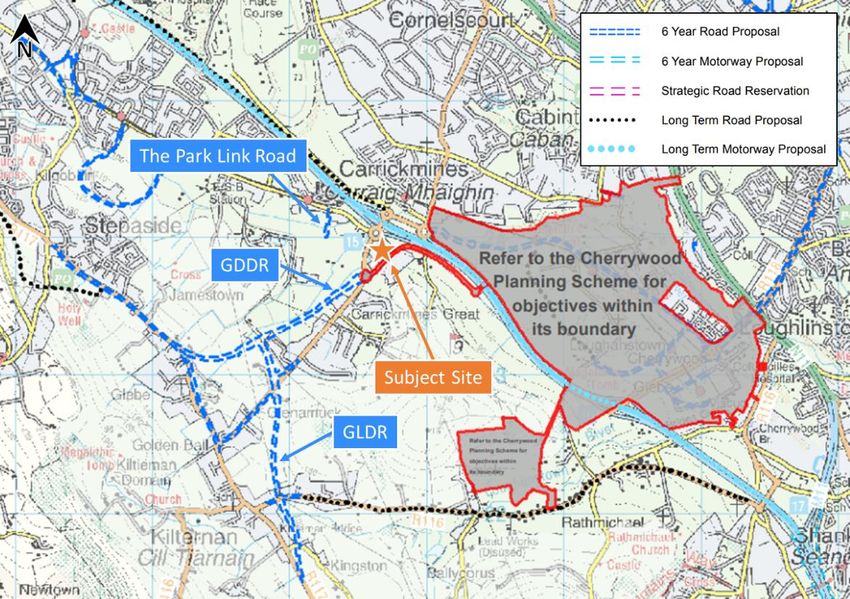
positioned between the Cherrywood SDZ and Kiltiernan LAP as illustrated in Figure 13.4 below.
Golf Lane, which is located immediately to the south / west of the site is located within the Cherrywood SDZ,
and is to be upgraded in the future to become the link road connecting Glenamuck Road (and J15 M50) with
the western portion of the SDZ lands via a new M50 overpass.
Figure 13.4: Location of Site within Greater Carrickmines Context (Source: GeoHive)
Existing Transportation Environment
Road Network
The subject development site fronts onto the Golf Lane corridor. Travelling eastbound from the site provides
access to Carrickmines Golf Club whilst travelling westbound from the site provides access to the Glenamuck
Road corridor. Travelling northbound on Glenamuck Road provides access to Cornelscourt/ Cabinteely/ N11,
Sandyford (4.5km) and Dundrum (8km) in addition to access to the strategic M50 Motorway (via Junction 15).
Travelling in a southbound direction along Glenamuck Road leads to Kilternan (approx. 2km) and Enniskerry
Road. Glenamuck Road is subject to a speed limit of 50kph.
Pedestrians and Cyclists
Pedestrians benefit from existing footway and street lighting provision on both sides of the Glenamuck Road
North corridor (as illustrated in Figure 13.5). The site of the proposed development benefits from relatively good
quality cycle facilities across the general area which include the availability of cycle lanes along Glenamuck
Road South corridor and on a number of links across the surrounding areas including Ballyogan Road. To the
south of the Golf Lane roundabout junction, pedestrians benefit from the provision of a footway and street
lighting on only one side (eastern side) of the Glenamuck Road South carriageway. There are currently no
dedicated cycle facilities along this section of the corridor (Figure 13.5). Pedestrians also benefit from the
provision of a footway and street lighting on the southern side of the Golf Lane corridor. Currently cyclists share
the Golf Lane corridor with vehicular traffic.
Chapter 13/ Page 4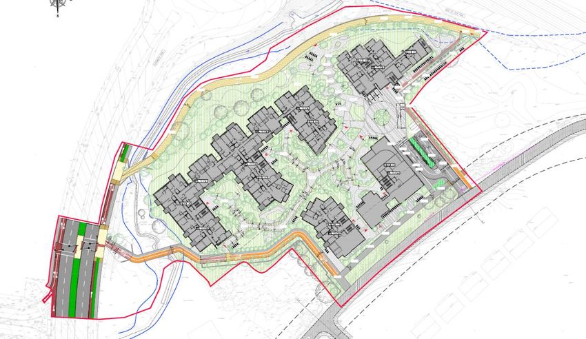
Golf Lane SHD
Environmental Impact Assessment Report Chapter 13 – Transportation
Glenamuck Road (Northbound) Glenamuck Road (Southbound)
Glenamuck Road South Corridor Golf Lane
Figure 13.5: Existing Pedestrian / Cycle Facilities on the Surrounding Road Network
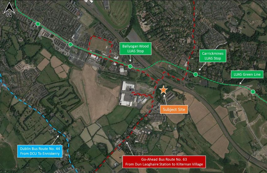
Public transport – bus
Go-Ahead operates a bus service in the vicinity of the subject site. Go-Ahead Bus Route 63 operates services
between Kilternan and Dún Laoghaire. As presented on Figure 13.6 below, the nearest Go Ahead Route 63
southbound bus stop (Bus Stop Number 7360) is located approximately 450m west of the subject site access
whilst the nearest northbound bus stop for Go-Ahead Bus Route 63 (Bus Stop Number 7324) is located
approximately 400m southwest of the subject site access.
Figure 13.6: Existing Go-Ahead Bus Interchanges (Source: GeoHive)
Chapter 13/ Page 5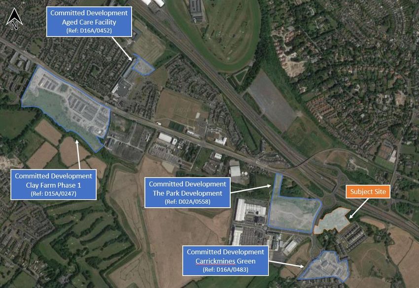
Golf Lane SHD
Environmental Impact Assessment Report                                                    Chapter 13 – Transportation

The Go-Ahead operated bus service operates on a daily basis seven days a week and offers frequent
schedules as summarised in Table 13.1 below.

    Route No.                             Route                   Mon – Fri        Sat                Sun
                               Dún Laoghaire – Kilternan               34           34                30
        63
                                Kilternan - Dún Laoghaire              33           34                30

  Table 13.1: Go-Ahead Bus Service Quantity (Source: TFI)

Public transport – LUAS

The closest LUAS Green Line interchanges (Ballyogan Wood and Carrickmines) are both located approximately
850m and within (approx. 11-minute) walking distance to the northwest and northeast of the subject site
respectively, via the Ballyogan Road and Glenamuck Road North. The LUAS Greenline currently provides
access to Sandyford, Dundrum and the City Centre to the north in addition to intermediate destinations along
its route (Figure 13.7). Table 13.2 below summarises the frequency with which the Luas Green Line service
operates.

                                    FIGURE 13.7: Luas Greenline Destinations (Source: LUAS)

         Time                  Monday – Friday                Saturday                    Sunday
         Peak                            4-10                   13-15                         11-12
     Off Peak               10-15                                 15                          12-15
Table 13.2: LUAS Service Frequency (minutes)

                                                                                                 Chapter 13/ Page 6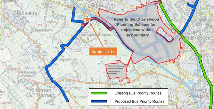
Golf Lane SHD
Environmental Impact Assessment Report                                                     Chapter 13 – Transportation

            Figure 13.8: Existing Public Transport Services

Public transport – Heavy Rail

Killiney Train Station is located approximately 4.5km east of the subject site whilst Dún Laoghaire Station is
5.5km to the northeast. Both of these interchanges provide access to DART and regional Commuter rail
services.

Future Transportation Environment

Cycle Network Proposals

(1) GREATER DUBLIN AREA CYCLE NETWORK PLAN

In December 2013, the NTA published the report entitled Greater Dublin Area Cycle Network Plan. The report
summarises the findings of a comprehensive body of work detailing a proposed Cycle Network incorporating
Urban, Inter-urban and Greenroute networks covering the six county council areas that together form the defined
Greater Dublin Area (GDA).

The subject site is located within the GDA Cycle Network sector designated as the “Dublin South East Sector”.
In the vicinity of the subject site the following route additions are proposed as indicated in Figure 13.9:

    •     Route 11C: south from Goatstown Cross on Drummartin Link Road/ Kilgobbin Road/ Ballyogan Road
          to Carrickmines,

    •     A new feeder route linking the Inter-Urban cycle route (D1) with a proposed Secondary cycle route
          along Glenamuck Road (11C), and

    •     New and extended Greenway route from Shanganagh to Sandyford along the Carrickmines Stream
          and Ballyogan.

                                                                                                 Chapter 13/ Page 7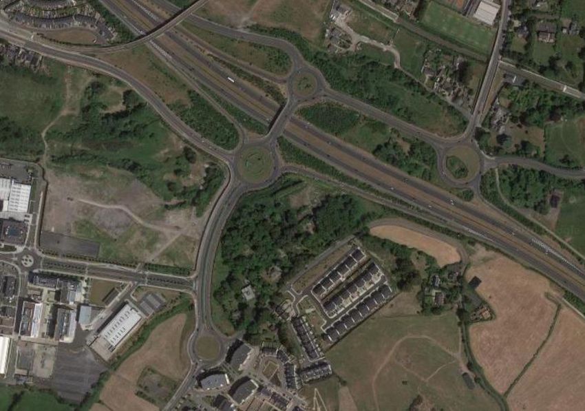
Golf Lane SHD
Environmental Impact Assessment Report                                                       Chapter 13 – Transportation

                         FIGURE 13.9: Proposed Cycle Network (Source: Sheet N8 GDA Cycle Network Plan)

(2) BALLYOGAN & ENVIRONS LOCAL AREA PLAN (BELAP) 2019-2025

Figure 4.11 and Table 4.6 of the BELAP outline the new linkages in the LAP area. The pedestrian / cycle links
proposed in the immediate vicinity of the subject development site include;

    •     Link No. 1 Glenamuck Road to Kilgobbin Road Greenway

                    “this dedicated Greenway Spine traversing the Plan area from east to west, would provide safe
                    and dedicated cycling/walking linkages through the central landholdings connecting Glenamuck
                    Road and Kilgobbin Road and continuing on the existing Greenway in Stepaside North to
                    Enniskerry Road”.

    •     Link No. 27 – Golf Lane Link

                    “Would link the Ballyogan Stream greenway spine (Link 1) through to the Kiltiernan Link Road”.

    •     Link No. 20 – The Park Carrickmines to Glenamuck Road

                    “This Link would connect the main ‘crossroads’ in The Park Carrickmines to the new Glenamuck
                    District Distributor Road, and onward to Glenamuck Road, providing a route from Kiltiernan to
                    The Park Carrickmines”.

Link No. 27 described above is indicatively shown to travel through the subject proposed development site.
Accordingly, a dedicated cycle / pedestrian link has been incorporated into the subject scheme proposals as
will be discussed in greater detail later in this chapter.

                                                                                                   Chapter 13/ Page 8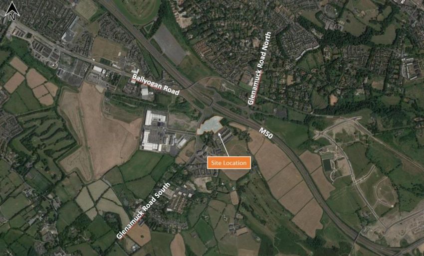
Golf Lane SHD
Environmental Impact Assessment Report                                                         Chapter 13 – Transportation

                                                               1

                                                                                   27
                                                                   20

                                         FIGURE 13.11: Future Cycle Infrastructure Proposals

Public transport Proposals – Bus Connects

BusConnects is an initiative launched by the National Transport Authority with the aim of overhauling the bus
system in the Dublin Region. This initiative includes review of bus services, the definition core bus network
which comprises radial, orbital and regional core bus corridors. It also includes enhancements to ticketing and
fare systems as well as transition to a new low emission vehicle fleet.

This initiative proposes to implement a redesign of the existing bus network. The fundamental changes to the
network expected would be as follows:

    •     Increasing the overall amount of bus services. Providing new and frequent orbital services connecting
          more outer parts of the city together;

    •     Simplifying the bus services on the key radial into “spines” where all buses will operate under a common
          letter system and buses will run very frequently and be more evenly spaced;
    •     Increasing the number of routes where buses will come every 15 minutes or less all day;

    •     The frequent network would become a web-shaped grid, with many interchange opportunities to reach
          more destinations. Everywhere that two frequent routes cross, a fast interchange is possible; and

    •     Additional service would be provided at peak hours to limit overcrowding.

In relation to the subject site, following this redesign of the bus network, the proposed development will be
located in close proximity to the new BusConnects route L26 which will replace the existing Go-Ahead Bus route
63. This bus service will operate every 30 minutes on a daily basis.

Figure 13.12 illustrates bus service proposals in the area and the frequency available for each route on a neutral
weekday as detailed in the BusConnects redesign (which was the subject of a third round of public consultation,
which closed on 16 December 2020).

                                                                                                     Chapter 13/ Page 9
Golf Lane SHD
Environmental Impact Assessment Report Chapter 13 – Transportation
The Bus Network Redesign is the first step in a series of transformative changes to Dublin’s bus network over
the coming years. However, the next steps in this initiative are the improvements to the infrastructure and
operation of the proposed Bus network which include:
• building a network of “next generation” bus corridors on the busiest bus lines to make bus journeys
faster, predictable and reliable;
• developing a state-of-the-art ticketing system using credit and debit cards or mobile phones to link with
payment accounts and making payment much more convenient;
• implementing a cashless payment system to vastly speed up passenger boarding times;
• a simpler fare structure, allowing seamless movement between different bus services without financial
penalty;
• new bus stops with better signage and information and increasing the provision of additional bus
shelters; and
• transitioning to a new bus fleet using low-emission vehicle technologies.
Figure 13.12: Proposed Bus Network (Source: BusConnects)
Public transport Proposals – Bus Priority
A Bus priority network is proposed within Map No. T2 of the DLRCC Development Plan 2016-2022 as presented
in Figure 13.13 below. The proposals include for a bus priority scheme along Glenamuck Road and continuing
through to the R117 Enniskerry Road South of the Enniskerry Road / Glenamuck Road junction.
Chapter 13/ Page 10Golf Lane SHD
Environmental Impact Assessment Report Chapter 13 – Transportation
Figure 13.13: Proposed Bus Priority Network (Source: Extract from Map No. T2 DLRCC Development Plan
2016-2022)
Public transport Proposals – Luas & Metro
According to current proposals by the NTA & TII, the proposed MetroLink will operate from Charlemont,
immediately south of the Grand Canal, and will provide links to City Centre locations and Dublin Airport,
terminating in Swords.
Residents of the proposed development will be able to avail of the proposed Metro Line through the Luas Green
Line services accessible at the, Ballyogan Wood or Carrickmines Luas interchanges.
Other proposed extensions to the Luas network include a Lucan Line operating from the City Centre to Lucan
and the extension of the Green Line south from Brides Glen to Bray. Figure 13.14 below shows the existing
Luas network with the proposed service extensions and Metro Line.
Figure 13.14: Proposed Light Rail Network (Source: NTA)
Chapter 13/ Page 11Golf Lane SHD
Environmental Impact Assessment Report Chapter 13 – Transportation
Public transport Proposals – Roads Proposals
Map No. T3 of the Dún Laoghaire Rathdown County Development Plan 2016-2022 presents the roads
proposals within the plan area to be completed within the lifetime of the plan (Figure 13.15).
Key road objectives in the general area of the subject site include;
• Glenamuck District Distributor Road (GDDR)
• Glenamuck Local Distributor Road (GLDR)
• The Park to Ballyogan Link Road
• Golf Lane M50 Overpass to Cherrywood SDZ
• M50 3rd Lane (Sandyford to M11)
Golf Lane M50 Overpass
Figure 13.15: Road Proposals Map (Source: Map T3 - Dún Laoghaire Rathdown County Development Plan 2016-
2022)
By reference to the County Development Plan, the following implementation timescales for these DLRCC roads
have been adopted within this chapter of the EIAR:
• Glenamuck District Distributor Road (GDDR) – after 2023 but before 2028
• Glenamuck Local Distributor Road (GLDR) – after 2023 but before 2028
• The Park to Ballyogan Link Road – after 2023 but before 2028
• Golf Lane M50 Overpass to Cherrywood SDZ – after 2038
• M50 3rd Lane (Sandyford to M11) – after 2038
Glenamuck District Distributor Road and The Glenamuck Link Distributor Road
It is noted that, as part of the GDDR scheme proposals, it is proposed that a new ‘fourth’ arm will be provided
at the Golf Lane / Glenamuck Road Roundabout as located on Glenamuck Road South.
Chapter 13/ Page 12Golf Lane SHD
Environmental Impact Assessment Report Chapter 13 – Transportation
Within the Kiltiernan / Glenamuck LAP 2013, these road proposals are identified as the Glenamuck District
Distributor Road (GDDR) and the Glenamuck Link Distributor Road (GLDR).
As part of the Kiltiernan / Glenamuck LAP 2013, a traffic modelling study was commissioned by DLRCC’s
transport planning section and carried out by RPS Consulting Engineers in order to ascertain as to whether the
aforementioned road infrastructure proposals, which were originally proposed as part of the previous LAP,
remain appropriate. The study consisted of an update of previous traffic modelling work carried out by the NTA
which was used to demonstrate the level of transport infrastructure necessary if all lands within the LAP where
developed.
The DLRCC commissioned traffic modelling study assumed a 2022 design year and predicted that all LAP lands
will be fully developed by that year. However, the study also acknowledged that this is highly unlikely and that
it may be decades before the entirety of the lands designated in the LAP would be developed.
Glenamuck District
Distributor Road
Glenamuck Link
Distributor Road
FIGURE 13.16: Kiltiernan / Glenamuck Local Area Plan 2013
The DLRCC commissioned traffic modelling study recommends that a phased approach is taken with regard to
the implementation of the road proposals and thereby proposes “Minimum Essential (Core) Roads
Infrastructure” will “need to be provided for lands to be developed in a sensible and sustainable manner”. The
proposed minimum essential (core) level of road infrastructure is proposed as follows;
A. “GDDR (Glenamuck District Distributor Road - (primary link road)) - single carriageway from
Enniskerry Road to Southern Roundabout at Carrickmines
B. GLDR (Glenamuck Link Distributor Road – (primary link road)) - single carriageway from Enniskerry
Road to GDDR
C. Junction of GDDR and GLDR
D. Staggered junction between GLDR and the existing Glenamuck Road
Chapter 13/ Page 13Golf Lane SHD
Environmental Impact Assessment Report Chapter 13 – Transportation
E. Junction of GLDR and Ballycorus Road
F. Junction of Enniskerry Road and GDDR”
Figure 13.17 below presents the proposed minimum essential (core) level of road infrastructure.
Figure 13.17: Minimum Essential (Core) Road Infrastructure (Source: Extract from RPS Dr.
No. PA0003 Minimum (Core) Infrastructure Proposals at Glenamuck-Kilternan)
The DLRCC commissioned traffic modelling study states that;
“As time passes and the development of the LAP lands and other areas in the wider environs
takes place, it is likely that other road infrastructure improvements, both within and outside of
the LAP area boundary may become necessary. Within the LAP area, the core infrastructure
would require upgrading. These improvements would include junction upgrades to multi-lane
facilities”
Therefore, whilst the aforementioned Minimum (Core) Infrastructure Proposals will be implemented in the
interim period, it is recommended in the DLRCC commissioned traffic modelling study that lands are protected
from development in order to cater for the potential future traffic demand arising from the fully developed LAP.
Figure 13.18 below illustrates the extent of the lands required for the implementation of the future road
infrastructure upgrade identified by RPS.
Chapter 13/ Page 14Golf Lane SHD
Environmental Impact Assessment Report Chapter 13 – Transportation
Figure 13.18: Long Term Road Infrastructure (Source: Extract from RPS Dr. No. PA0004
Long Term Infrastructure Proposals at Glenamuck-Kilternan)
In 2017, DLRCC appointed DBFL Consulting Engineers to update the earlier RPS traffic analysis and undertake
the detailed design of the GDDR and GLDR schemes. An application for approval in respect of the updated
road scheme has been submitted by DLRCC to An Bord Pleanála. Approval for the Glenamuck District Roads
Scheme and confirmation of the Dun Laoghaire-Rathdown County Council Compulsory Purchase (Glenamuck
District Roads Scheme) Order 2019 was granted on 18 December 2019 (Ref. Nos. ABP-303945-19 / ABP-
304174-19).
The updated traffic analysis by DBFL submitted in respect of the approved Glenamuck District Roads Scheme
includes all zoned lands within the LAP at a density of 45 units per Ha. Accordingly, the strategic area -wide
appraisal of the local road network following the implementation of development on lands zoned for residential
development (including the subject site) has been considered within the DLRCC commissioned analysis. This
strategic appraisal is based upon the delivery of housing and implementation of GDDR and GLDR infrastructure
by the end of 2020.
Chapter 13/ Page 15Golf Lane SHD
Environmental Impact Assessment Report Chapter 13 – Transportation
Figure 13.19: DBFL GDDR / GLDR Detailed Design (Extract from DBFL Dr. No. 170172-
DBFL-01-XX-DR-C-2000)
13.4 DESCRIPTION OF THE PROPOSED DEVELOPMENT
Proposed Development
The proposed development comprises a residential development of 482 no. units (all apartments), along with
ancillary residential amenities, and provision of a childcare facility, gym, and local shop. The proposed
residential units comprise 31 no. studio units, 183 no. 1-bedroom units, 229 no. 2-bedroom units, and 39 no.
3-bedroom units (including 2 no. duplex type units).
Two basement levels are proposed, providing car parking spaces (299 no.), bin stores, plant rooms, bicycle
parking (1000 no. spaces), and circulation areas. A further 240 no. bicycle parking spaces and 4 no. car parking
spaces are provided at ground level.
The proposed development includes landscaping, boundary treatments, public, private and communal open
space, two cycle / pedestrian crossings over the stream at the western side of the site, along with a new
pedestrian and cycle crossing of Glenamuck Road South at the west of the site, cycle and pedestrian facilities,
play facilities, and lighting. The proposed buildings include the provision of private open space in the form of
balconies and winter gardens to all elevations of the proposed buildings.
The development also includes vehicular, pedestrian, and cycle accesses, drop off areas, boundary treatments,
services, and all associated ancillary and site development works.
Chapter 13/ Page 16Golf Lane SHD
Environmental Impact Assessment Report Chapter 13 – Transportation
FIGURE 13.20: Proposed Site Layout
Further details of the above proposals in regard to the proposed residential development are illustrated in Henry
J Lyons Architects scheme drawings as submitted with this planning application.
Site Access Arrangements
Vehicular Access
The subject site will benefit from a single vehicle access which will be provided on Golf Lane as shown in Figure
4.2 below. It will be located approximately 255m northwest of the Glenamuck Road Roundabout.
The majority of vehicles entering the site (i.e. residents) will be directed down a short ramp and into the
basement car park. Other vehicles (such as deliveries, set down, visitors) will be accommodated at ‘podium’/
ground level near Blocks B and D pedestrian access points. A turning facility is proposed at podium level
allowing for drop off / collection purposes.
The overall development site has been set back to accommodate the future implementation of the DLRCC
proposed Golf Lane M50 Overpass to Cherrywood SDZ. The proposed set back and Golf Lane upgrade corridor
is presented in Figure 13.21 below.
Pedestrian & Cyclist Accessibility
In addition to the subject site’s main access (as located on Golf Lane) which accommodates access to the
subject development site by all modes as indicated in Figure 13.21 below, pedestrians/cyclists will be provided
with additional convenient dedicated access/egress locations along Glenamuck Road South and Golf Lane.
Dedicated cycle access ramps are proposed between surface level and upper basement level located adjacent
to the vehicular access and another located south of the tower accessed off the proposed cycle / ped facility
operating along the northern and north eastern site boundary. In addition, pedestrians may also access podium
level via an adjacent parallel dedicated pedestrian link from as presented in Figure 13.21 below.
Chapter 13/ Page 17Golf Lane SHD
Environmental Impact Assessment Report Chapter 13 – Transportation
Additional cycle access to
All Modes basement
Pedestrian / Cyclists
Additional pedestrian
Proposed new two-way cycle access to podium level
facility between connections to
external cycle network
Proposed new informal
pedestrian crossings
Location of proposed new Staggered Site set back to accommodate
pedestrian crossing granted under future DLRCC Golf Lane upgrade
Planning Ref. D18A/0257
Figure: 13.21: Proposed Site Accessibility
As introduced previously, the Ballyogan and Environs LAP proposes a new pedestrian link between Glenamuck
Road South and Golf Lane. Accordingly, the subject scheme proposals incorporate a new dedicated cycle /
pedestrian link between Glenamuck Road South and Golf Lane via the southwestern boundary of the subject
site. This new non-vehicular link connects with Golf Lane in the vicinity of the proposed new pedestrian crossing
on Glenamuck Road South granted as part of Planning Ref. D18A/0257. The proposed new footpath within the
subject site boundary has been set back from the existing Golf Lane corridor so that it can be retained as the
footpath along the future Golf Lane upgraded layout.
This new cycle / pedestrian facility will enhance accessibility to The Park retail development as well as the
neighbouring LUAS interchange on Ballyogan Road and bus stops on Glenamuck Road and at The Park.
Chapter 13/ Page 18Golf Lane SHD
Environmental Impact Assessment Report Chapter 13 – Transportation
Ballyogan Wood Luas Stop
Existing One-way cycle facility plus footpath
Existing Two-way cycle facility plus footpath
Figure 13.22: Pedestrian / Cycle Connectivity
Parking
The subject scheme proposals include for a total of 303 no. car parking spaces comprising 202 at upper
basement level, 97 at lower basement level and 4 no. at surface level. Of the 303 on-site car parking spaces,
10 no. have been assigned to the Creche / amenity / café / retail land uses. The surface level car parking spaces
comprise 3 no. visitor car parking spaces an 1 no. set down visitor space. A total of 289 no. basement car
parking spaces are dedicated to the residential units whilst the remaining 10 no. spaces are for the non-
residential uses.
This residential car parking provision is lower than the maximum development plan standards (632 spaces) and
equates to a ratio of 0.6 spaces per apartment unit. This sustainable approach is justified in circumstances of
where: i) the site’s close proximity to the frequent Luas services and bus stops, ii) the high level of cycle parking
provision proposed and iii) the policy of the DHPLG for new developments at such locations is for car parking
provision to be ‘minimised, substantially reduced or wholly eliminated in certain circumstances’. The opportunity
exists for a reduced quantum of dedicated residential car parking spaces to be provided for a development on
the subject site. In addition to the aforementioned basement level car parking spaces, 3 no. taxi / set down
space is proposed at podium level.
The non-residential on-site land uses (creche, gym / café, residential amenity) will predominantly cater for the
needs arising from the onsite residential development and, therefore, will not generate a significant number of
vehicular trips to and from the proposed development site. Accordingly, as introduced previously, a total of 10
no. car parking spaces have been allocated to non-residential land uses to facilitate staff associated with these
land uses travelling to the site by car. For childcare services, Table 8.2.4 of the development plan requires the
provision of a maximum of 1 car parking space per staff member (includes set down spaces). Accordingly,
assuming a total of 15 no. crèche staff, a maximum of 15 no. crèche car parking spaces are required as part of
Chapter 13/ Page 19Golf Lane SHD
Environmental Impact Assessment Report Chapter 13 – Transportation
the subject scheme proposals. It is noted that the crèche car parking requirement is inclusive of set down
spaces.
Accordingly, the opportunity exists for a sustainable reduction in the provision of crèche dedicated car parking
spaces as the subject facility is expected to predominantly serve the subject residential apartments. Therefore,
the vast majority of trips to the proposed crèche facility are expected to comprise walking trips to / from the
proposed residential apartments. The subject scheme proposes 6 no. dedicated crèche car parking spaces.
The remaining 4 no. non-residential car parking spaces have been assigned for staff at the retail, gym / café,
and amenity units. A summary of the car parking allocation is summarised in Table 13.3 below.
Setdown/Visitor at
Land Use Standard Disabled Car Share Electric Motorcycle
Surface
Residential 222 11 7 49
Crèche 5 1 - - 4 12
Non-residential 4 - - -
Sub-Total 231 12 7 49
4 12
Total 299
Table 13.3: Car / Motorcycle Parking Provision
Car Share
The subject scheme proposes the provision of 7 no. car share spaces located at basement level (included within
the 289 no. residential car parking spaces introduced above). Research has shown that 1 car share vehicle can
replace up to 15 private cars (Source: Transit Co-operative Research Programme – Report 108 ‘Car Sharing:
Where and How it Succeeds’).
Disabled Car Parking Provision
The development plan requires the provision of disabled car parking spaces at a rate of 4% of car parking
provision. Accordingly, a total of 12 no. disabled car parking spaces are required as part of the subject proposals.
The subject scheme proposes 12 no. disabled car parking spaces located within the upper basement level and
is therefore compliant with the development plan requirement.
Electric Vehicle Parking Provision
The development plan requires the provision of parking spaces capable of accommodating electric vehicles at
a rate of 1 car parking space per 10 residential units. Accordingly, a total of 49 no. electric vehicle compatible
parking spaces are proposed as part of the subject scheme (i.e. 10% of apartments).
Motorcycle Parking Provision
The subject scheme proposals accommodate 12 no. motorcycle spaces which is compliant with the
development plan standard which requires 4 no. motorcycle spaces per 100 car parking spaces.
Bicycle Parking Provision
The subject development proposals include for a total of 1240 bicycle parking spaces comprising 240 short term
bicycle spaces located at podium level and 1000 long term bicycle spaces within the upper basement level.
This level of overall cycle parking provision (1240) is more than double the DLRCC requirements (602) and
exceeds the DHPLG requirement (1052).
Chapter 13/ Page 20Golf Lane SHD
Environmental Impact Assessment Report Chapter 13 – Transportation
Trip Generation
Proposed Development
With the objective of examining the demand that could potentially be generated at the proposed residential
development, the following Donor site exercise has been undertaken to identify, survey and analyse existing
developments, which exhibit similar land-use (residential apartments) and operational characteristics to those
of the proposed development;
Following an analysis of existing residential developments which are located in close proximity to both the
Luas Green Line and a range of retail / leisure facilities; the following three sites have been adopted by DBFL
as representing appropriate ‘donor’ sites in terms of trip generation (i.e. all apartments) and public transport
accessibility (i.e. close proximity to LUAS services) characteristics. As such the three selected sites are as
follows (Figure 13.23):
A. Shanagarry Residential Development, Milltown Road, Dublin 6;
B. Elmfield Residential Development, Ballyogan Road, Leopardstown, Dublin 18; and
C. Tully Vale Residential Development, Cherrywood, Dublin 18
The trip rates presented in Table 13.4 below represents the corresponding ‘average’ trip rates calculated from
the three adopted donor sites during the local road networks AM and PM peak hour periods.
Figure 13.23: Donor Sites Locations
Chapter 13/ Page 21Golf Lane SHD
Environmental Impact Assessment Report Chapter 13 – Transportation
AM Peak Hour PM Peak Hour
Arr Dep 2-way Arr Dep 2-way
0.051 0.223 0.275 0.159 0.060 0.220
Table 13.4: Peak Hour Average Apartments Unit Vehicle Trip Rate
Based on the above trip rates, the potential peak hour traffic generation is calculated based on 482 apartments.
Table 13.5 summarises the predicted peak hour AM and PM traffic generated by the proposed development.
AM Peak Hour PM Peak Hour
Units
Arr Dep 2-way Arr Dep 2-way
482 25 107 132 77 29 106
Table 13.5: Proposed Residential Development - Vehicle Generation
The proposed community focused childcare facility will predominantly generate residents ‘walk in’ trips (and a
small number of staff trips) and therefore has not been included as part of the trip generation assessment.
Similarly, the gym / retail element of the development has not been included in the trip generation exercise as
this facility will cater for residents use only.
13.5 POTENTIAL IMPACT OF THE PROPOSED DEVELOPMENT
Construction Phase
During the general excavation of the foundations there will be additional HGV movements to / from the site.
Utilising typical construction rates, it is predicted that, during the excavation stage, there could be 2 no.
truckloads per hour equating to 4 no. two-way HGV movements per hour. Accordingly, assuming a 12 hour
working day, this equates to 48 no. two-way HGV movements per day on the local road network.
All suitable material will be used for construction and fill activities where possible and appropriate. All spoil
material will be removed to a registered landfill site which will be agreed in full with the Local Authority.
In addition to the traffic generated by the disposal of surplus subsoil from the site, there will be traffic generated
from deliveries of construction materials and equipment. It should be pointed out that construction traffic
generated during the development works tends to be outside of peak hours. Such trips would generally be
spread out over the full working day and will not be higher than the peak hour predicted volumes for the
operational stage.
Construction traffic will consist of the following categories:
• Private vehicles owned and driven by site construction staff and by full time supervisory staff. On-site
employees will generally arrive before 08:00, thus avoiding the morning peak hour traffic. These
employees will generally depart after 18:00.
• Excavation plant and dumper trucks involved in site development works and material delivery vehicles
for the following: granular fill materials, concrete pipes, manholes, reinforcement steel, ready-mix
concrete and mortar, concrete blocks, miscellaneous building materials, etc. Deliveries would arrive
at a dispersed rate during the course of the day.
The potential construction phase effects are characterised as being ‘direct’ and ‘negative’ but ‘imperceptible’ as
the vehicle generation during the construction stage have been calculated as resulting in just a percentage
increase of approximately 1% compared to the base traffic scenario. These effects are ‘likely’ to occur however
they will be ‘temporary’ in nature only lasting for the duration of the construction stage.
Chapter 13/ Page 22Golf Lane SHD
Environmental Impact Assessment Report Chapter 13 – Transportation
Operational Phase
Network Impact
The Institution of Highways and Transportation document ‘Guidelines for Traffic Impact Assessments’ states
that the impact of a proposed development upon the local road network is considered material when the level
of traffic it generates surpasses 10% and 5% on normal and congested networks respectively. When such levels
of impact are generated a more detailed assessment should be undertaken to ascertain the specific impact
upon the networks operational performance. These same thresholds are reproduced in the NRA document
entitled ‘Traffic and Transport Assessment Guidelines (2014)’.
Figure 13.24: Junction Locations (Network Impact)
In accordance with the IHT and NRA (TII) guidelines we have undertaken an assessment to establish the
potential level of impact upon the key junctions of the local road network. To enable this calculation to be
undertaken we have based the analysis upon the 2038 Future Design Year.
Ref Junction Location AM Peak PM Peak
1 Site Access/ Golf Lane 3-arm priority - -
2 Glenamuck Road South/ Golf Lane roundabout 6.26% 4.60%
3 Glenamuck Road/ Ballyogan Road/ M50 slip road 2.46% 1.89%
4 Glenamuck Road North/ Ballyogan Grove/ M50 slip road 1.46% 1.54%
5 Glenamuck Road North/ Carrickmines P&R/ M50 slip road 1.35% 1.21%
Table 13.6: Proposed Development’s Network Impact
The analysis demonstrates that the proposals will generate a subthreshold impact upon Junctions 2, 3, 4 and 5
as detailed in Table 13.6 above. Nevertheless, the impact at Junction 2 is recorded as being slightly over the
5% threshold (for congested networks) in the AM peak hour assessment. Accordingly, the operational
performance of Junctions 1 (site access junction) and key off-site Junction 2 (Glenamuck Road South /Golf
Lane Roundabout), has been subject to more detailed assessment using specialised junction modelling
software.
Chapter 13/ Page 23Golf Lane SHD
Environmental Impact Assessment Report Chapter 13 – Transportation
Figure 13.25 below details the amount of two-way vehicle trips to/from the proposed development site that will
travel through the Glenamuck Road / Golf Lane Roundabout Junction in the 2038 design year as result of the
proposed 482-unit residential development. The resulting percentage increase in traffic flows as a result of the
traffic generated by the proposed development is established as being below the 10% threshold at all key off-
site junctions however is predicted to be over the 5% threshold at Junction 2 in the AM peak hour. The following
scenarios have been considered in the network impact assessment;
Do Nothing:
• A1 – 2023 Base Flows + Committed Developments;
• A2 – 2028 Base Flows + Committed Developments; and
• A3 – 2038 Base Flows + Committed Developments.
Do Something:
• B1 – 2023 Do Nothing (A1) + Proposed Development Flows;
• B2 – 2028 Do Nothing (A2) + Proposed Development Flows; and
• B3 – 2038 Do Nothing (A3) + Proposed Development Flows.
For the key off-site junctions, it can be seen that the proposed development (482 units) would result in the
following increases in the 2038 Future Design Year:
• Junction 2 (Glenamuck Road/ Golf Lane roundabout): an increase of 6.26% (132 New Vehicle Trips)
in the AM peak period and 4.60% (106 New Vehicle Trips) in the PM peak period;
• Junction 3 (Glenamuck Road/ Ballyogan Road/ M50 slip road roundabout): an increase of 2.46% (99
New Vehicle Trips) in the AM peak period and 1.89% (74 New Vehicle Trips) in the PM peak period;
• Junction 4 (Glenamuck Road North/ Ballyogan Grove/ M50 slip road roundabout): an increase of
1.46% (51 New Vehicle Trips) in the AM peak period and 1.54% (46 New Vehicle Trips) in the PM
peak period;
• Junction 5 (Glenamuck Road North/ Carrickmine R&R/ M50 slip road roundabout): an increase of
1.35% (30 New Vehicle Trips) in the AM peak period and 1.21% (28 New Vehicle Trips) in the PM
peak period.
Junction 3 Junction 4
AM Peak Hour: AM Peak Hour:
99 New Vehicle Trips 51 New Vehicle Trips
4032 Existing Vehicle Trips 3473 Existing Vehicle Trips
2.46% Increase 1.46% Increase
PM Peak Hour: PM Peak Hour:
74 New Vehicle Trips 46 New Vehicle Trips
3923 Existing Vehicle Trips 2986 Existing Vehicle Trips
1.89% Increase 1.54% Increase
Junction 2 Junction 5
AM Peak Hour: AM Peak Hour:
132 New Vehicle Trips 30 New Vehicle Trips
2116 Existing Vehicle Trips 2224 Existing Vehicle Trips
6.26% Increase 1.35% Increase
PM Peak Hour: PM Peak Hour:
106 New Vehicle Trips 28 New Vehicle Trips
2301 Existing Vehicle Trips 2268 Existing Vehicle Trips
4.60% Increase 1.21% Increase
Figure 13.25: Increase in Vehicle Trips Generated Through Key Of-Site Junction in 2038 – 482
Units
Chapter 13/ Page 24Golf Lane SHD
Environmental Impact Assessment Report Chapter 13 – Transportation
Network Analysis
The operational assessment of the local road network has been undertaken using the Transport Research
Laboratory (TRL) computer packages ARCADY for roundabout junctions and PICADY for priority controlled
junctions.
When considering roundabout and priority controlled junctions, a Ratio of Flow to Capacity (RFC) greater than
85% (0.85) would indicate a junction to be approaching capacity, as operation above this RFC value is poor
and deteriorates quickly.
A 90-minute AM and PM period has been simulated, from 08:00 to 09:30 and 17:00 to 18:30. Traffic flows were
entered using an Origin-Destination table for the peak hours.
In order to determine if the proposed site access junction and key off-site junction will cater for the predicted
level of traffic generation, a traffic model of the site access junction was analysed for the scheme’s 2023 Opening
Year and subsequent 2028 and 2038 Future Design Years.
Junction 1: Site Access/ Golf Lane
The results of the operational assessment of this three-arm priority controlled junction during the weekday
morning and evening peaks are summarised in Table 13.7 below. The site access has been assessed in the
worst case 2038 Future Design Year only. The arms were labelled as follows within the PICADY model:
Arm A: Golf Lane (West)
Arm B: Site Access
Arm C: Golf Lane (East)
The 2038 “Do Something” scenario assumes that the 482 residential dwellings are built and occupied (in
addition to committed development traffic). The 2038 AM peak hour PICADY results (Table 13.7) indicate that
the Site Access / Golf Lane three arm priority junction will operate well within capacity with a maximum RFC
value of only 0.23 with a corresponding queue of 0.3 pcus being recorded.
Scenario Arm RFC Queue (pcu) Delay (s)
B-AC 0.23 0.3 8.88
AM Peak
C-AB 0.00 0.0 0.00
B-AC 0.06 0.1 7.41
PM Peak
C-AB 0.00 0.0 0.00
Table 13.7: 2038 PICADY Do-Something Analysis
The 2038 “Do Something” PM peak hour PICADY results also indicates that the junction will operate with a
significant amount of reserve capacity with a maximum RFC of 0.06 and a corresponding queue of 0.1 pcus
being recorded.
Junction 2: Glenamuck Road South/ Golf Lane
The results of the operational assessment of this three-arm roundabout junction during the weekday morning
and evening peaks are summarised in Tables 13.8 to 13.13 below. The arms were labelled as follows within the
ARCADY model:
Arm A: Glenamuck Road
Arm B: Golf Lane
Arm C: Glenamuck Road South
2023 AM Peak
The ARCADY results (Table 13.8) indicate that the junction will operate within capacity for the 2023 “Do Nothing”
AM peak hour with a maximum RFC value of only 0.69 and a corresponding queue of 2.2 pcu’s being recorded.
Chapter 13/ Page 25Golf Lane SHD
Environmental Impact Assessment Report Chapter 13 – Transportation
With the inclusion of the proposed development, the ARCADY results reveal that during the 2023 “Do
Something” AM period the junction will continue to operate within capacity with a maximum RFC value of 0.72
and a corresponding queue of 2.5 pcus recorded.
Scenario Arm RFC Queue (pcu) Delay (s)
1 0.34 0.5 2.05
Do Nothing 2 0.04 0.0 5.24
3 0.69 2.2 8.41
1 0.35 0.5 2.07
Do Something 2 0.20 0.2 6.21
3 0.72 2.5 9.44
Table 13.8: 2023 AM Peak ARCADY Analysis
2023 PM Peak
The results of the ARCADY based assessment (Table 13.9) demonstrate that the junction will operate within
capacity for the 2023 “Do Nothing” PM peak hour with a maximum RFC value of only 0.52 and a corresponding
queue of 1.1 pcus being recorded.
With the inclusion of the proposed development, the junction simulation results suggest that during the 2023
“Do Something” PM period the junction will continue to operate within capacity with a maximum RFC value of
0.55 and a corresponding queue of 1.2 pcus recorded.
Scenario Arm RFC Queue (pcu) Delay (s)
1 0.52 1.1 2.79
Do Nothing 2 0.04 0.0 7.39
3 0.43 0.7 4.40
1 0.55 1.2 2.95
Do Something 2 0.10 0.1 7.85
3 0.44 0.8 4.56
Table 13.9: 2023 PM Peak ARCADY Analysis
2028 AM Peak
It is assumed that the Glenamuck District Distributor Road will be in place during the 2028 Future Design Year.
This will result in the existing three arm roundabout upgraded to a four-arm roundabout. The arms were labelled
as follows within the ARCADY model for the enhanced four-arm roundabout:
Arm A: Glenamuck Road
Arm B: Golf Lane
Arm C: Glenamuck Road South
Arm D: Glenamuck District Distributor Road
The ARCADY results (Table 13.10) indicate that the junction will operate within capacity for the 2028 “Do
Nothing” AM peak hour with a maximum RFC value of 0.71 and a corresponding queue of 2.4 pcus being
recorded.
With the inclusion of the proposed development, the ARCADY results reveal that during the 2028 “Do
Something” AM period the junction will continue to operate within capacity with a maximum RFC value of 0.74
and a corresponding queue of 2.7 pcus recorded.
Chapter 13/ Page 26Golf Lane SHD
Environmental Impact Assessment Report Chapter 13 – Transportation
Scenario Arm RFC Queue (pcu) Delay (s)
1 0.32 0.5 1.96
2 0.04 0.0 4.92
Do Nothing
3 0.10 0.1 3.37
4 0.71 2.4 8.46
1 0.33 0.5 1.99
2 0.18 0.2 5.76
Do Something
3 0.10 0.1 3.55
4 0.74 2.7 9.49
Table 13.10: 2028 AM Peak ARCADY Analysis
2028 PM Peak
The results of the ARCADY based assessment (Table 13.11) demonstrate that the junction will operate within
capacity for the 2028 “Do Nothing” PM peak hour with a maximum RFC value of only 0.53 and a corresponding
queue of 1.1 pcus being recorded.
With the inclusion of the proposed development, the junction simulation results suggest that during the 2028
“Do Something” PM period the junction will continue to operate within capacity with a maximum RFC value of
0.55 and a corresponding queue of 1.2 pcus recorded.
Scenario Arm RFC Queue (pcu) Delay (s)
1 0.53 1.1 2.80
2 0.05 0.0 7.46
Do Nothing
3 0.08 0.1 3.94
4 0.45 0.8 4.39
1 0.55 1.2 2.96
2 0.10 0.1 7.92
Do Something
3 0.08 0.1 4.01
4 0.47 0.9 4.57
Table 13.11: 2028 PM Peak ARCADY Analysis
2038 AM Peak
The ARCADY results (Table 13.12) indicate that the junction will be operating within capacity for the 2038 “Do
Nothing” AM peak hour with a maximum RFC value of 0.76 and a corresponding queue of 3.0 pcus being
recorded.
Scenario Arm RFC Queue (pcu) Delay (s)
1 0.34 0.5 2.02
2 0.04 0.0 5.08
Do Nothing
3 0.10 0.1 3.45
4 0.76 3.0 10.14
1 0.35 0.5 2.04
2 0.19 0.2 5.98
Do Something
3 0.11 0.1 3.65
4 0.79 3.5 11.60
Table 13.12: 2038 AM Peak ARCADY Analysis
Chapter 13/ Page 27Golf Lane SHD
Environmental Impact Assessment Report Chapter 13 – Transportation
With the inclusion of the proposed development, the ARCADY results reveal that during the 2038 “Do
Something” AM period the junction will continue to operate within capacity with a maximum RFC value of 0.79
and a corresponding queue of 3.5 pcus recorded.
2038 PM Peak
The results of the ARCADY based assessment (Table 13.13) demonstrate that the junction will operate within
capacity for the 2038 “Do Nothing” PM peak hour with a maximum RFC value of 0.56 and a corresponding
queue of 1.2 pcus being recorded.
With the inclusion of the proposed development, the junction simulation results suggest that during the 2038
“Do Something” PM period the junction will continue to operate within capacity with a maximum RFC value of
0.58 and a corresponding queue of 1.4 pcus recorded.
Scenario Arm RFC Queue (pcu) Delay (s)
1 0.56 1.2 2.98
2 0.05 0.1 8.05
Do Nothing
3 0.08 0.1 4.11
4 0.48 0.9 4.64
1 0.58 1.4 3.16
2 0.11 0.1 8.60
Do Something
3 0.09 0.1 4.19
4 0.50 1.0 4.85
Table 13.13: 2038 PM Peak ARCADY Analysis
In summary, the introduction of additional traffic as a result of the operational phase of the proposed
development is predicted to result in effects that can be characterised as ‘not significant’ on the operational
performance of both the site access junction and the key off-site Golf Lane / Gllenamuck Road roundabout
junction. The predicted ‘not significant’ effect on the local road network is characterised as ‘direct’ and ‘negative’.
Nevertheless, this duration of effect is predicted to be ‘short-term’ as once the mobility management plan (as
submitted as part of this planning application) objectives are implemented, it is predicted that fewer vehicle trips
than those considered within the subject assessment will be generated thereby reducing the potential impact
further.
13.6 DO NOTHING IMPACT
In the absence of the proposed development, the overall operational performance of the existing junctions on
the surrounding road network will be affected by the impact caused by committed development and forecast
background network traffic growth (should that growth arise).
Although traffic growth may not increase at the rates once predicted, to ensure a robust analysis of the impact
of traffic upon the local road network we have adopted growth rates using the Transport Infrastructure Ireland
(TII) traffic projections. Table 6.1 (Unit 5.3 – Travel Demand Projections) within the TII Project Appraisal
Guidelines provides Annual Growth Factors for the different regions within Ireland. The subject site lies within
the ‘Dublin’ metropolitan area with the growth factors as outlined within Table 13.14 below.
Low Sensitivity Growth Central Growth High Sensitivity Growth
2016-2030 2030-2040 2016-2030 2030-2040 2016-2030 2030-2040
LV HV LV HV LV HV LV HV LV HV LV HV
1.0146 1.0280 1.0034 1.0116 1.0162 1.0295 1.0051 1.0136 1.0191 1.0328 1.0087 1.0172
Table 13.14: National Traffic Growth Forecasts: Annual Growth Factors (Source: Extract from Table 6.1
PAG)
Chapter 13/ Page 28Golf Lane SHD
Environmental Impact Assessment Report Chapter 13 – Transportation
Applying the annual factors as outlined in Table 6.3 above for the adopted Opening Year of 2023 and Future
Horizon Years of 2028 (Opening Year +5 years) and 2038 (Opening Year +15 years), the following growth
rates have been adopted to establish corresponding 2023, 2028 and 2038 baseline network flows.
• 2017 to 2023 – 1.1012 (or 10.12%);
• 2017 to 2028 – 1.1933 (or 19.34%); and
• 2017 to 2038 – 1.2695 (or 26.95%).
13.7 POTENTIAL CUMULATIVE IMPACTS
The analysis detailed above under Section 13.5 (Operational Stage) represents an appraisal in terms of
potential cumulative impacts for a typical weekday as it is focused upon the key two busiest periods of the day
(i.e. AM and PM peak hours). During the other 22 hours of the day, traffic flows are predicted to be significantly
lower resulting in the network operating with additional reserve capacity to that forecast for the peak hour
periods.
In addition, the following third party committed developments have been included in the network analysis
detailed within Section 13.5 (Operational Stage) are located within the area of influence of the subject site and
have been considered as part of the assessment of the development proposals:
• Site 1 (Carrickmines Green Site D16A/0483): Planning permission granted for modifications to the
residential development under Planning Ref. D11A/0312, D12A/0262 and D14A/0338 in October 2016
by Dún Laoghaire Rathdown County Council. The development will consist of the construction of a block
of 3 no. 3-storey terraced houses in lieu of 5 units which were omitted under condition 5 of Planning
Ref. D11A/0312. The parent planning permission reference is D04A/0327 which was for 227 residential
units.
• Site 2 (The Park, Carrickmines Site): The Park, Carrickmines has been subject to 3 significant
planning applications. Phase 1 comprised mainly of retail warehousing and office accommodation
(Planning Ref. D02A/0558) and related to the southwest and southeast quadrants. Phase 2 comprised
of retail warehousing, comparison retailing office and hotel accommodation (Planning Ref. D03A/1239)
and related to the northwest and northeast quadrants. Permission was granted in April 2008 (Planning
Ref. D07A/0936) for amendments to previously permitted development Reg. Ref. D03A/1239). A
planning application on the site (Planning Ref. D12A/0163) was refused planning permission in June
2012 by the Planning Authority for a mixed-use District Centre development with a GFA of 58,863m2.
• Site 3A (Clay Farm Phase 1 - D15A/0247): Phase 1 of the Clay Farm masterplan lands (a two-phase
development) was granted a seven-year planning permission (Planning Ref: D15A/0247) for 425
residential units by Dún Laoghaire Rathdown County Council on 19th April 2016.
• Site 3B (Clay Farm Phase 1C - ABP30428819): The application site relates to the westernmost part
of Phase 1C of the permitted Phase 1 Clay Farm development (ABP Ref: PL06D.246601 / DLRCC Reg.
Ref.: D15A/0247). The proposed development relates to the provision of 192 no. apartments in two no.
blocks and was granted planning permission by ABP in July 2019.
• Site 3C (Clay Farm Phase 2 - ABP30152218): Application to An Bord Pleanála for a ten year
permission for a strategic housing development consisting of 927 no. residential units, a neighbourhood
centre containing a childcare facility with a GFA of c. 604 sqm and 2 no. retail units each and was
granted planning permission by ABP in August 2018.
• Site 4 (Aged Care Facility D16A/0452): Permission was granted in August 2016 by Dún Laoghaire
Rathdown County Council for the construction of a part four storey, part five storey Aged Care Facility
to accommodate 224 no. bedrooms and ancillary resident and staff facilities, with a GFA of 12,580m 2
over a single level basement with a GFA of 2,020 m2.
Chapter 13/ Page 29You can also read