Towrie (PL 1059) Rehabilitation Monitoring Plan - November 2021 - Santos
←
→
Page content transcription
If your browser does not render page correctly, please read the page content below
Towrie (PL 1059)

Rehabilitation Monitoring Plan

November 2021
Table of Contents
Abbreviations ........................................................................................................................................ 4
1     Introduction .............................................................................................................................. 5
       1.1 Background ...................................................................................................................... 5
       1.2 Scope ............................................................................................................................... 5
       1.3 Limitations ........................................................................................................................ 7
2     Roles and Responsibilities...................................................................................................... 8
3     Existing environment ............................................................................................................... 9
       3.1 Land use .......................................................................................................................... 9
       3.2 Climate ............................................................................................................................. 9
       3.3 Landform and soils ........................................................................................................... 9
       3.4 Vegetation ...................................................................................................................... 10
       3.5 Environmentally sensitive areas .................................................................................... 11
4     Rehabilitation techniques...................................................................................................... 13
       4.1 Topsoil Management ..................................................................................................... 13
       4.2 Sodic Soil Amelioration .................................................................................................. 13
       4.3 Soil Compaction ............................................................................................................. 13
       4.4 Contaminated Land ........................................................................................................ 13
       4.5 Watercourse Crossings .................................................................................................. 13
       4.6 Landform Management .................................................................................................. 13
       4.7 Revegetation .................................................................................................................. 13
       4.8 Mulching and Placement of Vegetation ......................................................................... 14
       4.9 Weed Management ........................................................................................................ 14
       4.10 Pest and Livestock Management ................................................................................... 14
5     Disturbance Lifecycle and Maintenance Monitoring .......................................................... 15
       5.1 Pipelines ......................................................................................................................... 15
       5.2 Well Pads ....................................................................................................................... 15
       5.3 Facilities ......................................................................................................................... 16
       5.4 Roads and tracks ........................................................................................................... 16
6     Rehabilitation acceptance requirements ............................................................................. 17
       6.1 Transitional Rehabilitation Monitoring ............................................................................ 18
           6.1.1        Reprofiling and topsoil ........................................................................................ 19
           6.1.2        Groundcover ....................................................................................................... 19
           6.1.3        Erosion ............................................................................................................... 19
       6.2 Final Rehabilitation Acceptance Criteria (FRC) ............................................................. 20
           6.2.1        Groundcover ....................................................................................................... 20
           6.2.2        Revegetation ...................................................................................................... 20
       6.3 Environmentally Sensitive areas .................................................................................... 20
7     Rehabilitation Monitoring Requirements ............................................................................... 1
       7.1 Final Rehabilitation Register ............................................................................................ 1
       7.2 Risk based methodology .................................................................................................. 1
           7.2.1        High risk areas – rework/rectify ............................................................................ 1
           7.2.2        Medium risk areas – maintain/monitor ................................................................. 1
           7.2.3        Low risk areas – site relinquishment .................................................................... 1
       7.3 Monitoring ........................................................................................................................ 1
           7.3.1        Data capture ......................................................................................................... 2
       7.4 Final acceptance reporting ............................................................................................... 4
8     Reference .................................................................................................................................. 5

List of Tables
Table 1: Environmental Authority Rehabilitation Schedule Conditions ................................................... 5
Table 2: Description of Topography and Soils within Towrie .................................................................. 9
Table 3: Vegetation communities within the Project Area assessed by AECOM ................................. 10
Table 4: Environmentally Sensitive Areas ............................................................................................ 11
Table 5 Proposed formal monitoring frequency ...................................................................................... 2
Table 6 TRC Monitoring parameters ....................................................................................................... 2
Table 7 FRC Monitoring parameters ....................................................................................................... 3
List of Figures Figure 1 Final Rehabilitation Flowchart ................................................................................................. 18
Abbreviations
ATP              Authority to Prospect
CCA              Conduct and Compensation Agreement
CG               Coordinator-General
DAMP             Decommissioning and Abandonment Management Plan
EA               Environmental Authority
ESA              Environmentally Sensitive Area
ESC              Erosion and Sediment Control
FRC              Final Rehabilitation Criteria
FRCA             Final Rehabilitation Criteria plus additional
GFD Project      Gas Field Development Project
GLM              Grazing Land Management
GLNG             Gladstone Liquefied Natural Gas
LNG              Liquefied Natural Gas
NC Act           Nature Conservation Act 1992
PL               Petroleum Lease
PPL              Petroleum Pipeline Licence
RE               Regional Ecosystem
RoW              Right of Way (Pipelines)
Santos           Santos GLNG Pty Ltd
the Project      Santos GLNG Gas Field Development Project
TRC              Transitional Rehabilitation Criteria
1     Introduction
1.1   Background
Santos CSG Pty Ltd (Santos), PAPL (Upstream) Pty Limited, Total E&P Australia III, KGLNG E&P Pty
Ltd, and Australian Pacific LNG (CSG) Pty Limited have applied for a new resource authority –
Petroleum Lease (PL) 1059 (under assessment). An Environmental Authority (EA), P-EA-1001309995,
has been granted for PL1059.
PL 1059, known as Towrie, is located in the Surat / Bowen Basins of Eastern Queensland,
approximately 60 kilometres north north-east of Injune. The tenure is located immediately west of the
existing Arcadia field, operated by a joint venture between Santos GLNG Pty Ltd (Santos), PAPL
(Upstream II) Pty Ltd, Total GLNG Australia (TOTAL) and KGLNG Liquefaction Pty Ltd (KOGAS),
known as GLNG Operations. GLNG Operations have approval to deliver coal seam gas (CSG) from
the CSG fields in Central Queensland (including Arcadia, Fairview, Roma and Scotia) to a liquefied
natural gas (LNG) facility on Curtis Island.
This Rehabilitation Plan has been prepared by Santos Onshore Environment Team to address condition
I1 of EA P-EA-100130995. It is based on the certified and approved Upstream Rehabilitation
Monitoring Plan (3380-GLNG-4-1.3-0202) for the Fairview Arcadia, Roma, Roma East, Scotia and
Maisey project areas within GLNG Operations.

1.2   Scope
The content of this Plan has been written to meet and/or exceed the final rehabilitation requirements
under EA P-EA-100130995 for PL1059. This Plan covers all petroleum activities authorised to occur
under EA P-EA-100130995 whether or not they are planned to occur during the Plan of Operations
period for the first phase of activities (16 December 2021 to 15 December 2026).
Rehabilitation conditions, and references to where each is addressed, are identified in Table 1.
                  Table 1 Environmental Authority Rehabilitation Schedule Conditions

 EA P-EA-1001309995 Condition                                                                        Section
                                                                                                     addressed

 I1      A Rehabilitation Plan must be developed by a suitably qualified person and must include     This plan
         the:
         (a) rehabilitation goals; and

         (b) procedures to be undertaken for rehabilitation that will:
                  (i). achieve the requirements of conditions (I2) to (I8) inclusive; and
                  (ii). provide for appropriate monitoring and maintenance.

 I2      Transitional Rehabilitation                                                                 Section 6.1
         Significantly disturbed areas that are no longer required for the on-going petroleum
         activities, must be rehabilitated within 12 months (unless an exceptional circumstance in
         the area to be rehabilitated (e.g. a flood event) prevents this timeframe being met) and
         be maintained to meet the following acceptance criteria:
         (a)      contaminated land resulting from petroleum activities is remediated and
         rehabilitated;

         (b) the areas are:
                  (i). non-polluting;
                  (ii). a stable landform;
                  (iii). re-profiled to contours consistent with the surrounding landform
EA P-EA-1001309995 Condition Section
addressed
(c) surface drainage lines are re-established;
(d) top soil is reinstated; and
(e) either:
(i). groundcover, that is not prohibited or restricted pest species, is growing; or
(ii). an alternative soil stabilisation methodology that achieves effective
stabilisation is implemented and maintained.
I3 Remaining Dams Section 6.1
Where there is a dam, (including a low consequence dam) that is being or intended to
be used by the landholder or overlapping tenure holder, the dam must be
decommissioned to no longer accept inflow from the petroleum activity(ies) and the
contained water must be of a quality suitable for the intended ongoing uses(s) by the
landholder or overlapping tenure holder.
I4 Pipeline Activities Section 5.1
Pipeline trenches must be backfilled, and topsoils reinstated within three months after
pipe laying.
I5 Reinstatement and revegetation of the pipeline right of way must commence within 6 Section 5.1
months after cessation of petroleum activities for the purpose of pipeline construction.
I6 Backfilled, reinstated, and revegetated pipeline trenches and right of ways must be: Section 5.1
(a) a stable landform;
(b) re-profiled to a level consistent with surrounding soils;
(c) re-profiled to original contours and established drainage lines; and
(d) vegetated with groundcover which is not a prohibited or restricted pest species, and
which is established and growing.
I7 Final Rehabilitation Acceptance Criteria Section 6.2
All significantly disturbed areas caused by petroleum activities which are not being or
intended to be utilised by the landholder or overlapping tenure holder, must be
rehabilitated to meet the following final acceptance criteria measured either against the
highest ecological value adjacent land use or the pre-disturbed land use:
(a) greater than or equal to 70 per cent of native ground cover species richness
(b) greater than or equal to the total per cent ground cover
(c) less than or equal to the per cent species richness of prohibited or restricted pest
species
(d) where the adjacent land use contains, or the pre-clearing land use contained, one
or more regional ecosystem(s), then:
(i). at least one Regional Ecosystem(s) from the same broad vegetation group,
as demonstrated by the predominant species in the ecologically dominant layer,
must be present; and,
(ii). the Regional Ecosystem present in (I7)(d)(i) must possess an equivalent
or higher conservation value (biodiversity status) than the Regional
ecosystem(s) in either the adjacent land or pre-disturbed land.
I8 Final Rehabilitation Acceptance Criteria in Environmentally Sensitive Areas Section 6.3EA P-EA-1001309995 Condition Section
addressed
Where significant disturbance to land has occurred in an environmentally sensitive area,
the following final rehabilitation criteria as measured against the pre-disturbance
biodiversity values assessment (required by conditions (D1) and (D2)) must be met:
(a) greater than or equal to 70% of native ground cover species richness;
(b) greater than or equal to the total per cent ground cover;
(c) less than or equal to the per cent species richness of Prohibited or restricted pest
species;
(d) greater than or equal to 50% of organic litter cover;
(e) greater than or equal to 50% of total density of coarse woody material; and
(f) all predominant species in the ecologically dominant layer, that define the pre-
disturbance regional ecosystem(s) are present.
1.3 Limitations
It should be noted that prior to formal decommissioning, transitional rehabilitated areas have the
potential to be required again and hence disturbed several times as part of staged field development
activities.
This plan does not address the decommissioning, demolition or abandonment of infrastructure at the
cessation of Project activities as identified in the Santos GLNG Decommissioning and Abandonment
Management Plan (DAMP). Decisions for infrastructure to remain or be abandoned in-situ described in
the DAMP includes consideration of the feasibility and likely success of rehabilitation outcomes outlined
as part of this plan. Conduct and Compensation Agreements (CCAs) between Santos and landholders
can also stipulate the retention and transfer of ownership of assets to the landholder once operations
have ceased. This plan does not consider the rehabilitation of transferred assets but does ensure the
asset is safe, stable and non-polluting.2 Roles and Responsibilities Santos GLNG Operations personnel are responsible for the environmental performance of their activities, for complying with relevant approval/permit requirements and for ensuring that all environmental objectives associated with the work are achieved. Santos GLNG Project personnel must also be mindful of the General Environmental Duty as outlined in the Environmental Protection Act 1994 (Qld) (EP Act). Section 319 of the EP Act states that “a person must not carry out any activity that causes, or is likely to cause, environmental harm unless the person takes all reasonable and practical measures to prevent or minimise the harm.”
3      Existing environment
3.1    Land use
The tenure encompasses freehold, leasehold, and a small local council reserve in the north-east corner
of the tenure. The majority of freehold tenure within the area is for the purposes of pastoral activities
(i.e. agriculture or grazing).
Key industries within the wider region surrounding Towrie include agriculture, forestry, recreation and
tourism, coal exploration and mining, and oil and gas exploration and production. The traditional industry
base for the region has been agricultural, however in more recent times the oil and gas industry has
become a more significant contributor to the region’s economy.
PL 1059 is wholly overlapped by Exploration Permit – Coal (EPC) 1772 held by Tri-star Coal Company.

3.2    Climate
Injune Post Office (site number 043015) is the closest Bureau of Meteorology (BOM) weather station
to Towrie. Monthly climate statistics from this weather station indicate that Injune has a warm, sub-
tropical environment receiving an average of 631.6 millimetres of rain per year (BOM 2020). While
rainfall occurs throughout the year, the highest rainfall occurs from October to March. Mean minimum
and maximum temperature range from 3.3–20.2 °C in July to 19.8–33.8 °C in January.

3.3    Landform and soils
Towrie is located within the Brigalow Belt bioregion and straddles the Carnarvon Ranges and Arcadia
subregions. The Carnarvon Ranges subregion is an extensive belt of predominantly coarse sandstones
that form the north-eastern margin of the Great Artesian Basin. These have been partly dissected to
form an undulating to hilly surface with areas of deep valleys and gorges. Soils are predominantly
coarse, with deep sands or with deep sandy-surfaced texture contrast soils on less steep areas.
The Arcadia subregion is formed primarily on Triassic sediments of the Bowen Basin with minor areas
of Permian sediments in the east. Eastern, southern and western areas are predominantly rugged on
coarse sandstones while the central and northern areas are more undulating and largely contained
within a broad valley. Soils include clay and shallow texture-contrast.
There are two distinct landscapes present in Arcadia—a well-defined north-south valley that is visually
defined by prominent ridge lines along its eastern and western edges, and a visually prominent
mountain range east of the valley comprising a system of deeply incised valleys draining to the east.
Towrie is situated in the valley, with a small section comprising the ridgeline. Elevation within PL 1059
ranges from approximately 310 metres Australian height datum (m AHD) in the east to 640 m AHD in
the west. The valley section comprises a large portion of PL 1059 which has been significantly disturbed
by blade ploughing, vegetation clearing, and agricultural activities.
The Atlas of Australian Soils maps five soil landscapes within PL 1059 (Northcote et al, 1960-68). These
are described in Table 2.
                       Table 2: Description of Topography and Soils within Towrie

    Soil landscape
                                    Unit description                             Dominant soil types
          unit
                     Moderately undulating lands with some low          Dominant are red and loamy duplex
         Oa4
                     hills                                              soils.
                     Low hilly to hilly terrain on volcanic rocks and
                     appearing as open valleys in steep hilly to        Chief soils are neutral, dark and yellow
        MM7
                     mountainous land, gentle to moderate side          friable earths with friable brown soils.
                     slopes to shallow streams with significant flats
                     Level or very gently undulating alluvial plains    Loams with weakly developed brown
         Rf6
                     fringing drainage-ways                             clay subsoils.
Soil landscape
Unit description Dominant soil types
unit
Moderately undulating lands with some Dominant soils are brown loamy
Rf3 rounded low hills and occasional higher duplex soils with associated loamy red
closely dissected hilly areas soils.
High hilly to mountainous strongly dissected
Rudosols, with dark sandy or loamy-
Bz1 sandstone ranges & plateaux with strong
surfaced duplex soils on valley floors.
scarps & often deep narrow ravines
3.4 Vegetation
Biodiversity values within Towrie reflect the historical agricultural land use of the area. Around 84% of
the project area has previously been cleared of native vegetation and is currently mapped by DES as
non-remnant.
The extent, condition, dominant species and conservation significance of each vegetation communities
within the project area are identified in Table 3.
Table 3: Vegetation communities within the Project Area assessed by AECOM
Vegetation RE Extent within project area BD1/ Area
Community VM Act2 (ha)
Status
Brigalow low open HVR This vegetation community occurs on undulating E/E 63.94
forest on alluvial 11.3.1 plains, along shallow and narrow drainage lines
plains within the Survey Area. In the wider Project Area it
is also mapped in the northern central area of
2TR13 and eastern extent of 2SP200046.
Brigalow open forest 11.3.1 This vegetation community was field-validated to E/E 200.43
on alluvial plains occur in the Public Reserve and in patch along the
unnamed tributary of Station Creek (eastern extent
of Project Area). In the wider Project Area,
scattered patches are considered to occur within
2TR13 while large connected tracts occur within
2SP200046, generally in association with mapped
VM Act watercourses.
Eucalyptus populnea 11.3.2 This vegetation community was confirmed along a OC / 26.86
+/- Eucalyptus shallow drainage line on low undulating plains at OC
melanophloia open one location within the Survey Area. Within the
forest on alluvial wider Project Area, it is considered to also occur in
plains two large patches on the eastern boundary and in
six patches along a mapped watercourse in
2SP200046.
Eucalyptus 11.3.25 This vegetation community occurs along the OC / LC 26.51
camaldulensis unnamed tributary of Station Creek that traverses
riparian woodland the Project Area in the east. It is also considered to
occur along Arcadia Creek, in the north east of the
Project Area.
SEVT with brigalow 11.9.4a Within the Survey Area this vegetation community E / OC 0.71
understorey was confirmed on a steep low hill just north of
Middle Hill. In the wider Project Area.
SEVT 11.9.4 This community was confirmed within the western E / OC 613.20
ridgeline during the field survey, and identified
within Middle Hill by Terrestria.Vegetation RE Extent within project area BD1/ Area
Community VM Act2 (ha)
Status
SEVT regrowth HVR This community occurs on the exterior and lower E / OC 48.21
11.9.4 slopes of the western ridgeline and Middle Hill.
Outside of these areas, an additional four small
patches are mapped to the north in 2TR13. A
review of historical aerial imagery indicates that
historical clearing has occurred in these areas, and
as such the vegetation is likely to be in HVR
condition.
Brigalow low open HVR This vegetation community was confirmed to occur E/E 45.37
forest on 11.9.5 in scattered patches on low hills within the Survey
sedimentary rock Area. In the wider Project Area, scattered patches
are also mapped to occur in the western extent,
especially within the 2SP200046 property south of
Middle Hill.
Brigalow low open HVR This community was not encountered during the E/E 3.01
forest with SEVT 11.9.5a field survey however is expected to occur as small
understorey discrete patches in the northern Project Area,
based on the findings of the aerial imagery and
LiDAR assessment.
Brigalow open forest 11.9.5 This community was not encountered during the E/E 48.15
on sedimentary rock field survey however is expected to occur as
scattered patches across the Project Area, primarily
in the western extent of 2SP200046 based on the
findings of the aerial imagery and LiDAR
assessment.
Corymbia citriodora 11.10.1 This community was not encountered during the NCAP / 2.52
woodland on coarse- field survey however is expected to occur within LC
grained sedimentary Middle Hill based on the findings of the Terrestria
rocks assessment and State vegetation mapping.
Eucalyptus 11.10.4 This vegetation community occurs within the NCAP / 795.34
decorticans open Project Area on fine-grained sedimentary rocks LC
forest on along the steep hill slopes of the western ridgeline.
sedimentary rock
Regrowth - Small patches of regrowth vegetation were NA/NR 406.46
observed across the Survey Area, largely beside
tracks and along drainage lines.
Cleared exotic - Large portions of the Survey Area comprise NA/NR 6,097.44
pasture historically cleared pasture dominated by exotic
buffel grass. Cover in many areas was dense due
to the restricted access to cattle.
1 Biodiversity (BD) status of the RE based on an assessment of the condition of remnant vegetation in addition to the pre-
clearing and remnant extent of a regional ecosystem. NCAP=No Concern at Present; OC=Of Concern; E=Endangered
2 Conservation status of the RE under the VM Act; NR=Non-remnant; LC=Least Concern; OC=Of Concern; E=Endangered.
3.5 Environmentally sensitive areas
The ecology within Towrie supports limited areas of remnant and regrowth endangered and of concern
vegetation – comprising Category B and C Environmentally Sensitive Areas (ESAs). No Category A
ESAs are present within the tenure. The assessed extent of ESAs are listed in Table 4.
Table 4: Environmentally Sensitive Areas
ESA Category ESA Type Assessed extent (ha)
Category A Not present 0
Category B Endangered Regional Ecosystem 1023.02ESA Category ESA Type Assessed extent (ha) Category C Of Concern Remnant Regional Ecosystem 53.37
4      Rehabilitation techniques
There are a number of techniques available to Santos to carry out rehabilitation works, where required,
to achieve the requirements of the conditions listed in Table 1. Regardless of the technique employed,
monitoring is key to understanding the success of rehabilitation across the asset lifecycle.

4.1    Topsoil Management
Topsoil that is stripped and stored as part of construction activities is to be re-spread as part of
stabilisation and rehabilitation activities. Correctly preserved topsoil resources can provide viable
sources of seed-stock, biological life and nutrient conditions that assist with soil productivity and fertility,
and thereby vegetation establishment.

4.2    Sodic Soil Amelioration
Sodic soils when encountered will be blended with an appropriate soil ameliorant (i.e. gypsum, lime)
during rehabilitation processes to reduce dispersiveness. A good layer of topsoil will be placed on top
of sodic soils during rehabilitation works. Amelioration with gypsum and/or lime or addition of organic
mulch can improve soil structure, infiltration and soil aeration can promote vegetation establishment.

4.3    Soil Compaction
For long-term disturbances such as well leases, it is likely that the soil will have become compacted
over time. Where necessary, the soil will be treated (i.e. deep ripped) to alleviate the soil compaction.
This will occur prior to reshaping the upper layers of the soil stratum.

4.4    Contaminated Land
Where there is a risk of contaminated land occurring, a site-specific contaminated land assessment and
subsequent management plan may be developed for each asset. The scale and type of contamination
will determine the chosen management strategy. Small volumes may be disposed offsite via facilities
licenced to accept the waste whereas larger volumes may be managed on site using landfarming
techniques.

4.5    Watercourse Crossings
Where clearing of riparian vegetation is unavoidable, the objective will be to reinstate the creek banks
and riparian vegetation, as soon as practical post-construction. To minimise erosion and destabilisation
of creek banks, erosion controls will be constructed or installed, where necessary. The surface will
typically be lightly scarified before spreading the topsoil, to promote regeneration of native vegetation
and prevent loss of topsoil.

4.6    Landform Management
Sites will be reprofiled to a safe and stable landform, with surface drainage lines and topsoil profile re-
instated. Where practical, sites will be reprofiled to contours consistent with the surrounding landform.
However, where this is not practical (ie cut and fill operations on slopes, or within highly dispersive
soils), a stable landform will be reinstated by surface re-profiling, contouring or benching. Methods to
reshape the landform will vary depending on the level of disturbance.

4.7    Revegetation
Active seeding will be completed on all areas of disturbance where revegetation is required to ensure
stability during operations or to meet transitional and/or final rehabilitation criteria. Within areas of native
vegetation, a combination of tube-stock and seeding may be implemented. Tube-stock will be used for
canopy and shrub species, while a combination of tube-stock and seeding is appropriate for herbs,
forbs and grasses. Species will be selected based on assessments of the adjacent vegetation
community composition and other appropriate benchmark guidelines.

4.8   Mulching and Placement of Vegetation
Vegetation cleared during construction phases, will be retained on-site for use during stabilisation
and/or rehabilitation activities. Mulch and vegetation may be respread over the site as required. This
will assist in site stabilisation, revegetation efforts and suppressing weed growth.

4.9   Weed Management
Weed management will be required to enable the regeneration of pre-disturbance land uses and to
ensure that the disturbance does not allow for the introduction of new species to an area or increase
the localised population of a species. Weed control requiring chemicals will be undertaken by licenced
contractors under the Agricultural Chemicals Distribution Control Act 1966. All chemical application will
be carried out in strict accordance with registered labels and SDS requirements and considering any
Minor Use Permit PER11463 requirements as issued by the Australian Pesticides and Veterinary
Medicines Authority for ground-based herbicide application in non-agricultural areas (ie, bushland
areas).

4.10 Pest and Livestock Management
Where livestock occur within areas undergoing rehabilitation, temporary stock fencing may be erected
to ensure cattle/pigs etc cannot damage rehabilitation works. Fencing will be erected primarily to well
pads, laydowns etc where there is a localised disturbance footprint. Rehabilitation of linear infrastructure
is more difficult to fence and will require detailed planning to ensure cattle remain off site for as long as
practicable.
5       Disturbance Lifecycle and Maintenance Monitoring
The disturbance lifecycle can be defined by three distinct stages: construction, operation and final
rehabilitation. Regardless of the stage, all works aim to achieve a safe, stable, and non-polluting
landform. All new disturbance works are planned, approved, and recorded in a GIS database.
During the construction stage, works are undertaken using standardised designs. These designs
include both temporary (construction) and long-term erosion and sediment controls (ESC).
During the operational stage, a risk-based inspection program is implemented to ensure installed ESC
is functioning and disturbed areas are stabilising through vegetation growth. Maintenance actions will
be implemented where monitoring identifies that performance criteria are not being met. Maintenance
repairs are scheduled and prioritised using a risk-based approach.
The final rehabilitation stage is undertaken once an asset is assessed to be no longer required for the
petroleum activity and are not assets being retained by the landholder. Sections 6-7 provide specific
details outlining the final rehabilitation process and ensuring all EA conditions are met.

5.1     Pipelines
Pipeline right-of-ways (RoW’s) are cleared, pipelines installed, and land reinstated in quick succession.
This methodology reduces exposure of unprotected subsoils, preserves topsoil characteristics e.g.
structure, native seed bank etc, and minimises potential impacts from significant rainfall events.
As per the EA conditions, reinstatement is undertaken to ensure:
      (a) a stable landform
      (b) re-profiled to a level consistent with surrounding soils
      (c) re-profiled to original contours and established drainage lines; and
      (d) vegetated with groundcover which is not a declared pest species, and which is established
          and growing.
In addition, RoW’s (including ancillary infrastructure i.e. temporary laydowns) are reinstated
immediately following pipeline construction (within 3 months) with considerations made for a range of
factors including ESC, soil amelioration, fertiliser and seeding. These considerations are applied to
ensure timely (within 6 months) revegetation of the pipeline right of way.
Santos has standardised watercourse reinstatement designs that are assigned to crossings based the
site-specific risk profile. Watercourses are assessed as part of the planning phase and designs advised
for each crossing based on several inputs e.g. soil type, catchment, modelled flows, bank profiles. There
are five key options for reinstatement, three standard reinstatement designs (low, medium and high), a
fourth site-specific design and a fifth where standard pipeline reinstatement is deemed adequate.
Annual desktop assessments are undertaken using up-to-date aerial imagery to identify potential ESC
and integrity issues. The locations are inspected onsite and maintenance repairs prioritised based on
risk. In addition to the annual assessments, issues identified during standard work schedules are
recorded within a central database to capture, monitor, maintain and/or repair issues as they arise.

5.2     Well Pads
Santos has developed a catalogue of standardised construction designs that focus on long-term stability
for the operational life of the well, generally greater than 20 years. Using standardised designs Santos
achieves consistent and high-quality execution whilst minimising future disturbances. Where standard
designs are deemed not fit for purpose, site specific designs are developed.
All wells are monitored throughout operations using a risk-based inspection program. The program
establishes inspection frequencies using attributes such as soil type, slope, and proximity to sensitive
receptors. In practice, a higher risk site e.g. cut/fill well pad in poor soils within an Environmentally
Sensitive Area (ESA), has a higher inspection frequently than a low risk site e.g. low impact well pad on grazing land. Inspections target a range of environmental aspects which are weighted 0 to 2 (0 being low risk and 2 high risk). The sum of all aspects provides the final inspection score. Maintenance works are then prioritised based on the final inspection score e.g. well pads with high inspection scores hold the most environmental risk and are prioritised for maintenance. This allows maintenance works to be prioritised using the most up-to-date data and ensures Santos’ environmental risk is the lowest possible at any given time. 5.3 Facilities These assets typically cover a large disturbance footprint whereby the risk of erosion and sediment issues is elevated. To reduce risk and ensure long-term stability, all facilities (compressor stations, water treatment plants, laydowns etc) are constructed using site specific designs that are prepared during the early planning phase. Post-construction, environmental inspections are scheduled annually and assessed against rehabilitation and stability criteria. Any identified issues are recorded with a central database to monitor, maintain and/or repair. 5.4 Roads and tracks For unsealed roads and tracks the key techniques to minimise erosion and damage are good shaping (camber, elevation etc) and good drainage. These techniques are imbedded in the standardised construction designs. Watercourse crossings are assessed as part of the early planning phase and designs advised for each crossing based on several inputs e.g. soil type, catchment, modelled flows, bank profiles. In some instances, the standardised design is deemed unsuitable and a site-specific design will be developed. When planning for roads, considerations are made for existing and/or proposed adjacent infrastructure. Where construction occurs alongside adjacent infrastructure, the erosion and sediment controls marry into both pieces of infrastructure so as to not cause unwanted drainage or erosion impacts from one to the other i.e. surface waters are controlled across the entire disturbance footprint. Roads will undergo routine maintenance grades throughout the life of the infrastructure. These will typically follow high vehicle traffic and/or wet weather. In addition to the routine maintenance, any unforeseen issues are captured and stored within a central database for priority maintenance. Once roads are no longer required for petroleum activities, they will be offered to the landholder as an asset. Any roads unwanted by the landholder will be rehabilitated. This will include removal of any gravel, ripping, levelling and re-profiling to reinstate natural contours of the land (including any watercourses) and revegetating to match the surrounding land-use.
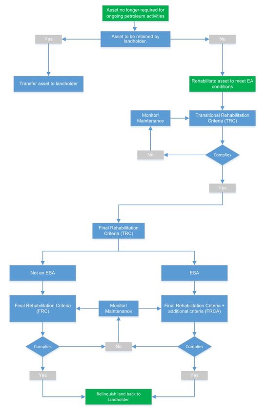
6     Rehabilitation acceptance requirements
Final rehabilitation requirements apply when assets that are no longer required for ongoing petroleum
activities and are not assets being retained by the landholder. The transfer of infrastructure assets to
landholders will be undertaken in compliance with the Department of Environment and Science
Guideline for Petroleum Activities (ESR/2020/5403) before the surrender of the environmental authority
or petroleum tenure. Areas classified as Environmentally Sensitive Areas (ESA) are excluded from
being transferred to landholders.
For the purposes of this plan, assets being retained by the landholder are not subject to final
rehabilitation.
To meet final rehabilitation for relinquishment all other assets must first meet the transitional
rehabilitation criteria as shown in Figure 1.
Figure 1 Final Rehabilitation Flowchart

6.1     Transitional Rehabilitation Monitoring
For the purposes of this plan, transitional rehabilitation is defined as the minimum rehabilitation criteria
to which each disturbed area must comply within 12 months of decommissioning/abandonment. The
transitional rehabilitation criteria (TRC) are:
      (a) contaminated land resulting from petroleum activities is remediated and rehabilitated
(b) the areas are:
(i) non-polluting;
(ii) a stable landform;
(iii) re-profiled to contours consistent with the surrounding landform
(c) surface drainage lines are re-established;
(d) topsoil is reinstated; and
(e) either:
(i) groundcover, that is not a declared pest species, is growing; or
(ii) an alternative soil stabilisation methodology that achieves effective stabilisation is
implemented and maintained.
Transitional rehabilitation activities are to be undertaken within 12 months following
decommissioning/abandonment activities. Immediately upon decommissioning sites will be monitored
for compliance against the transitional rehabilitation criteria and may require a combination of
techniques as described in Section 4.
6.1.1 Reprofiling and topsoil
Where reprofiling and topsoil has been demonstrated as stable (has constructed drainage, rock
reinforcement, stable cover and/or no evidence of erosion) data and geo-located photos should be
gathered during monitoring. Areas which have not been reprofiled and demonstrated as stable will need
to be maintained or reworked according to the extent of instability.
If problematic soils are identified, remediation actions will be required to decrease the area of bare
ground. This may include reworking, capping/reburial of poor substrates or the improvement of soils
using suitable materials.
6.1.2 Groundcover
In areas of poor groundcover assessments should be made to determine if the soil needs improvement
and possible re-seeding.
6.1.3 Erosion
Where erosion has been identified the area may require rework and maintenance. Erosion should be
monitored to ensure that any rehabilitated area is stable. If erosion monitoring shows that the erosion
is unstable and continuing to get worse, the area will need to be maintained or reworked depending on
the extent of the instability. If erosion is unchanging and has good vegetation cover the area may not
need any further maintenance or re-work, especially if it has been identified in well-established
rehabilitation.
When a site is assessed as compliant with the TRC it can then progress to the final rehabilitation stage.6.2 Final Rehabilitation Acceptance Criteria (FRC)
Once areas are assessed as meeting the transitional rehabilitation criteria, they are to be rehabilitated
to meet the following final acceptance criteria measured either against the highest ecological value
adjacent land use or the pre-disturbed land use:
(a) greater than or equal to 70 per cent of native ground cover species richness
(b) greater than or equal to the total per cent ground cover
(c) less than or equal to the per cent species richness of declared plant pest species
(d) where the adjacent land use contains, or the pre-clearing land use contained, one or more
regional ecosystem(s), then:
a. at least one Regional Ecosystem(s) (RE) from the same broad vegetation group, as
demonstrated by the predominant species in the ecologically dominant layer, must be
present; and,
b. the Regional Ecosystem present must possess an equivalent or higher conservation
value (biodiversity status) than the Regional Ecosystem(s) in either the adjacent land
or pre-disturbed land
All rehabilitation during the FRC stage will be undertaken in accordance to the site specific
requirements.
6.2.1 Groundcover
The area may require direct seeding and/or planting of ground layer, shrub and tree species depending
on the final post-disturbance land use. Weed control methods may also be required.
6.2.2 Revegetation
The selection of species to be used in rehabilitation where native vegetation is the final land use should
consider structural and floristic composition of the or the pre-disturbed land use or the highest ecological
value adjacent land use.
6.3 Environmentally Sensitive areas
Environmentally Sensitive Areas (ESAs) in PL 1059 include ‘Endangered’ and ‘Of Concern’ Regional
Ecosystems.
Where petroleum activities have resulted in significant disturbance to land in an ESA, the following final
additional rehabilitation criteria as measured against the pre-disturbance biodiversity values
assessment must be met:
(a) greater than or equal to 50 per cent of organic litter cover;
(b) greater than or equal to 50 per cent of total density of coarse woody material; and
(c) all predominant species in the ecologically dominant layer, that define the pre-disturbance
Regional Ecosystem(s) are present.7 Rehabilitation Monitoring Requirements Monitoring will inform rehabilitation decisions in relation to remediation of non-conformances relating to transitional criteria. Where required, data will be compared to the pre-disturbed land use data or an analogue site in the highest ecological value adjacent land use. 7.1 Final Rehabilitation Register A Final Rehabilitation Register (FRR) will capture the results of rehabilitation against the set compliance conditions. All monitoring data will be captured in a GIS database and a “traffic light report” will be generated to understand the progress of rehabilitation using a risk-based assessment methodology. 7.2 Risk based methodology Upon decommissioning/abandonment, a risk-based approach will be used to proactively identify the compliance risk level based on the intended final land use and progress towards the FRC. A site may contain a combination of the below risk profiles. 7.2.1 High risk areas – rework/rectify High risk areas are classified as areas requiring rework or rectification in order to meet the TRC and/or FRC. High risk areas (rework/rectification) may require a combination of stabilisation works, reprofiling and/or reseeding/revegetation works on decommissioning/abandonment. An area that is deemed high risk will require a review of the rehabilitation works based on the final land use requirements. Fencing, where practical, should remain intact until FRC are met. 7.2.2 Medium risk areas – maintain/monitor Medium risk areas are those areas meeting the TRC but require time and potentially maintenance to meet the FRC. Fencing, where practical, should remain intact until FRC are met. 7.2.3 Low risk areas – site relinquishment Low risk areas are defined as rehabilitated areas meeting the TRC and FRC and are ready for final acceptance and site relinquishment. 7.3 Monitoring On decommissioning/abandonment, formal monitoring should be undertaken against the TRC and FRC. The status of sites should be entered into the FRR along with any recommended rehabilitation requirements. Based on this initial assessment, formal monitoring frequency will be assessed on a case by case basis and may depend on weather conditions and predicted time to meet the rehabilitation criteria. As a guide the following formal monitoring schedule is proposed as a minimum to inform rehabilitation requirements.
Table 5 Proposed formal monitoring frequency

 Risk rating          Rehabilitation Status         Monitoring frequency          Method
 High risk areas      Rework/Rectify                Annually                      Remote sensing / ground survey/
                                                                                  sampling
 Medium risk          Maintain/monitor              Annually (pending             Remote sensing / ground survey/
 areas                                              weather conditions)           sampling
 Low risk areas       Ready for site                Based on previously           On-ground Third Party
                      Relinquishment                collected data                Rehabilitation Assessment &
                                                                                  Reporting

7.3.1   Data capture

Monitoring data indicators for Transitional Rehabilitation Criteria (TRC) and Final Rehabilitation Criteria
(FRC) and shown in Tables 6 and 7 respectively.
                                       Table 6 TRC Monitoring parameters

 Land use      TRC                                     Monitoring data indicators

 All           Contaminated land resulting from        Where there is a risk, or records confirming contaminated
               petroleum activities is remediated      land (i.e. hydrocarbon/chemicals) occurring from petroleum
               and rehabilitated                       activities, remediate to meet legislative requirements.

               Stable landform, non-polluting and      No run-off or subsidence caused by the decommissioning
               re-profiled to contours consistent      of petroleum activities. Erosion no more that surrounding
               with the surrounding landform           landscape. Re-profiled to natural landform or where not
                                                       practical reprofiled to ensure stability and ESC.

               Surface drainage lines are re-          No evidence of ponding, landform reinstated to be
               established                             consistent with drainage in surrounding landscape

               Topsoil is reinstated                   Where disturbed during decommissioning, reinstated
                                                       topsoil is consistent with surrounding soil profile of the site.
                                                       No evidence of soil profile mixing or compaction.

               Groundcover, that is not a declared     No restricted species present on site. Ground cover stable
               pest species, is growing OR an          across site.
               alternative soil stabilisation
               methodology that achieves effective
               stabilisation is implemented and
               maintained
Table 7 FRC Monitoring parameters
Land use FRC Monitoring data indicators/ methodology
All Greater than or equal to 70 per cent Comparison with analogue site in either the highest
of native ground cover species ecological value adjacent land use or the pre-disturbed
richness land use
The 50x10m plot method of the BioCondition Assessment
methodology V2.2 as per Eyre et al. (2015) or any
subsequent updated version is to be used in the
rehabilitated area in comparison to the analogue site.
Greater than or equal to the total Comparison with analogue site in either the highest
per cent ground cover ecological value adjacent land use or the pre-disturbed
land use
The 1x1m quadrats method of the BioCondition
Assessment methodology V2.2 as per Eyre et al. (2015)
or any subsequent updated version is to be used in the
rehabilitated area in comparison to the analogue site.
Per cent ground cover will be categorised into gradients
ofLand use FRC Monitoring data indicators/ methodology
ESA only Greater than or equal to 50 per cent Comparison with analogue site in either the highest
of organic litter cover ecological value adjacent land use or the pre-disturbed
land use
The 1x1m quadrats method of the BioCondition
Assessment methodology V2.2 as per Eyre et al. (2015)
or any subsequent updated version is to be used in the
rehabilitated area in comparison to the analogue site.
Greater than or equal to 50 per cent Comparison with analogue site in either the highest
of total density of coarse woody ecological value adjacent land use or the pre-disturbed
material land use
The 50x20m plot method of the BioCondition Assessment
methodology V2.2 as per Eyre et al. (2015) or any
subsequent updated version is to be used in the
rehabilitated area in comparison to the analogue site.
All predominant species in the Comparison with analogue site in either the highest
ecologically dominant layer, that ecological value adjacent land use or the pre-disturbed
define the pre-disturbance Regional land use
Ecosystem(s) are present
The 100x50m plot method of the BioCondition
Assessment methodology V2.2 as per Eyre et al. (2015)
or any subsequent updated version is to be used in the
rehabilitated area in comparison to the analogue site.
Where plot sizes are reduced, adjustments to calculations will be required to adequately scale up data
from plots to hectare rates.
7.4 Final acceptance reporting
When an area is meeting the final rehabilitation acceptance criteria (deemed low risk), landholders will be
requested to formally accept the return of land as part of the asset relinquishment process. A final
acceptance report will be completed by a suitably qualified third party in preparation for relinquishment to
the landholder.8 Reference Neldner, V.J., Wilson, B.A., Dillewaard, H.A., Ryan, T.S., Butler, D.W., McDonald, W.J.F, Addicott, E.P. and Appelman, C.N. (2019) Methodology for survey and mapping of regional ecosystems and vegetation communities in Queensland. Version 5.0. Updated March 2019. Queensland Herbarium, Queensland Department of Environment and Science, Brisbane Eyre, T.J., Kelly, A.L, Neldner, V.J., Wilson, B.A., Ferguson, D.J., Laidlaw, M.J. and Franks, A.J. (2015). BioCondition: A Condition Assessment Framework for Terrestrial Biodiversity in Queensland. Assessment Manual. Version 2.2. Queensland Herbarium, Department of Science, Information Technology, Innovation and Arts, Brisbane. Department of Environment and Science (effective 16 Sept 2020), Guideline Petroleum Activities - Transferring petroleum infrastructure to landholders, https://environment.des.qld.gov.au/management/activities/non-mining/community-landholder/transfer- infrastructure
You can also read