Topography and drainage system evolution in the ''Volubilis basin'' (South Rifain Ridges, Northern Morocco)
←
→
Page content transcription
If your browser does not render page correctly, please read the page content below
GEOGACETA, 70, 2021

      Topography and drainage system evolution in the ‘‘Volubilis
           basin’’ (South Rifain Ridges, Northern Morocco)
      Topografía y evolución de los sistema de drenaje en «cuenca de Volubilis» (Cadenas sud-rifeñas, Marruecos)

                          Afaf Amine1*, Hmidou El Ouardi2, Maria mazouar3, Mohamed Habibi2 and Mustapha Boualoul2

                  1
                    Geosciences laboratory, Department of Geology, Faculty of Sciences, Mohammed V University in Rabat, 4 Avenue Ibn Batouta, B.P. 1014-Morocco.
                            2
                              Equipe CartoTec, Department of Geology, Faculty of Sciences, University Moulay Ismail, PB. 11201 Zitoune, Meknès, Morocco.
   3
     Equipe SEINE, Department of Geology, Faculty of Sciences, University Moulay Ismail, PB. 11201 Zitoune, Meknès, Morocco a.amine@um5r.ac.ma, h.elouardi@umi.ac.ma, maria.
                                                     mazouar@gmail.com, m.habibi@umi.ac.ma, m.boualoul@umi.ac.ma

                                  ABSTRACT                                                                                    RESUMEN
    The Volubilis piggy -back basin, located at the front of the Rif                          La cuenca de piggy-back de Volubilis, situada en el frente del Rif
belt, northern Morocco, is a subsided area, as a continuation of the                      es una área deprimida localizada en el frente del cinturón orogénico,
deformational orogenic ridges, related to the present-day African                         formado a su vez en relación con con la convergencia entre Africa
and Eurasian convergence. For the first time, by morphotectonic stu-                      y Eurasia. Este estudio morfotectónico novedoso analiza por prime-
dies, we analyzed the topographic evolution and drainage systems                          ra vez la topografía y la respuesta de los sistemas de drenaje a la
response. Our results proved the influence of active tectonics in the                     tectónica. Nuestros resultados demuestran una influencia de la tec-
drainage network and topography of the Volubilis basin. The young                         tónica reciente en la topografía. Los indicios de la fase más reciente
phase is indicated by a less dissected planation surface comparing to                     están en relación con una superficie de erosión menos disecada en
the ridges, as well as by the ε-shaped hypsometric curve of the khou-                     relación con las zonas elevadas, así como con la curva en del perfil
mane river. This latter drains the continuation of the basin and the                      del río Khoumane. Este último drena la continuación de la cuenca
eastern arc, where the tectonic activity is mostly concentrated. Based                    y arco oriental, donde se concentra la mayor parte de la actividad
on swath analysis, the general trend of tilting was characterized and                     tectónica. A partir del análisis de perfiles swath se ha caracterizado el
was attributed to the recent tectonic movement combined with folds                        patrón general de basculamiento, relacionado con los movimientos
growth of the ridges.                                                                     tectónicos recientes y levantamiento de cadenas.

Key-words: Volubilis piggy-back basin, topographic evolution,                             Palabras clave: Cuenca piggy-back de Volubilis, evolución topo-
morphotectonics, South Rifian Ridges, Morocco.                                            gráfica, morfotectónica, cadenas sud-rifeñas, Marruecos.

Geogaceta, 70 (2021), 11-14                                                                                                             Fecha de recepción: 01/01/2021
ISSN (versión impresa): 0213-683X                                                                                                        Fecha de revisión: 23/04/2021
ISSN (Internet): 2173-6545				                                                                                                        Fecha de aceptación: 28/05/2021

Introduction

     The Volubilis piggy-back basin is loca-
ted between two curved thrusts that form
the South Rifian Ridges, northern Moroc-
co. It has a sub-circular morphology and
an approximate extension of 450 km2. Sin-
ce the middle Miocene-early Tortonian,
the basin formation has been associated
with the activity of these movable arcs,
whose southwestward displacement is re-
lated to the present-day African-Eurasian
convergence (Roldán et al., 2014).
     Neotectonic features in the Volubi-
lis basin reveal active subsidence of the
basin and presence of active folds su-
rrounding the basin related with defor-
mation in the orogen associated to the
present-day convergence between the                        Fig. 1. Geological map of the Volubilis Basin (modified from Roldán et al., 2014 and Fau-
African and Eurasian plates (Amine and                     gères, 1978). DNR-Dehar en Nsour; NR-Nesrani; KnR-Kannoufa; TaR-Takerma; Zer-Zer-
                                                           houn; FBR-Fert El Bir and MB-Moussaoua Basin. Ver la figura en color en la web.
El Ouardi, 2017; Amine et al., 2020 a & b).
                                                           Fig. 1. Mapa geológico de la cuenca de Voluibilis (modificado de Roldán et al., 2014 y Faugères,
In this work, we analyze the topography                    1978). DNR-Dehar en Nsour; NR-Nesrani; KnR-Kannoufa; TaR-Takerma; Zer-Zerhoun; FBR-Fert
evolution of the Volubilis basin to infer                  El Bir y MB-Cuenca de Moussaoua. See color figure in the web.

Copyright© 2021 Sociedad Geológica de España / www.geogaceta.com                                                                                                               11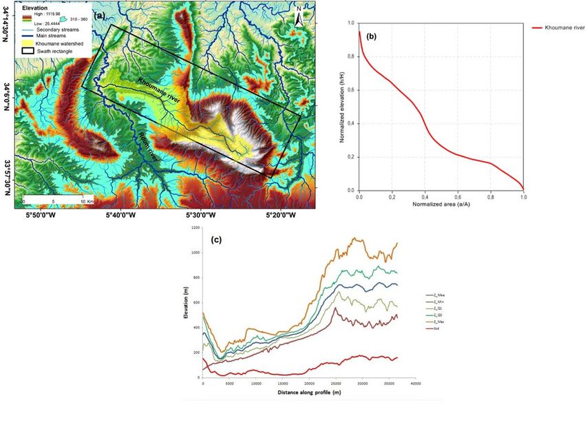
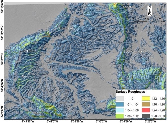
GEOGACETA, 70, 2021                                                                     A. Amine, H. El Ouardi, M. Mazouar, M. Habibi and M. Boualoul

Fig. 2. (a) Automatic extraction of the indissected outcrops (b) Histogram of elevation versus area frequency. Ver la figura en color en la
web.
Fig. 2. (a) Extracción automática de afloramientos no incididos. (b) histograma de altitud frente a superficie. See color figure in the web.

Fig. Fig. 3. The selected elevation of less dissected area and the swath location, (b) hypsometric curve and (c) Swath profiles along the
Khumane course. Ver la figura en color en la web.
Fig. 3. La elevación seleccionada del área menos disecada y la ubicación de la franja, (b) curva hipsométrica y (c) Perfiles de franja a lo largo del
curso Khoumane. See color figure in the web.

12                                                                                  Cuaternario y geomorfología / Quaternary and Geomorphology
Topographic evolution of the Volubilis basin, northern Morocco                                                        GEOGACETA, 70, 2021

how the recent tectonics influence on the           parameters were calculated for catego-             pattern might refer to the differences in
spatial variations of erosion, the tilting of       ries, also plotting the result on diagrams.        the levels of uplift in the area (Fig. 3a).
units and the drainage system.                                                                         1 Hypsometry and surface roughness
                                                    Results and conclusions
Geological setting                                                                                         In an attempt to interpret the warping
                                                        Figure 3a shows how the Khoumane               river course, the hypsometry of all the stud-
     The plates motion produced tilting             river is crossing the eastern anticlines ex-       ied area (Fig. 2b) and the hypsometric curve
and even overturning of the thick carbo-            periencing high uplift rate (Amine et al.,         of the Khoumane were obtained (Fig. 3b).
natic Jurassic series, forming the domi-            2020a) and the Volubilis basin. The river              Edges of harder rocks (310m-380m)
nant South Rifian Ridges reliefs.                   shows an abnormal ESE deflection, into             are accumulated in a planation surfa-
     The stratigraphic pile is composed by:
                                                    the basin to gain the Rdom river. This             ce, into the basin and show less dis-
(1) Triassic evaporates, which do not out-
crop at surface and facilitate the propa-
gation of the ridge folds, (2) a thick car-
bonatic Jurassic series, which forms the
dominant South Rifian Ridges reliefs, (3)
a marly Cretaceous series present only
in the Eastern Ridges, and (4) Miocene
rocks, unconformably overlying the Me-
sozoic rocks, which constitute the main
sedimentary materials of the basin (Fau-
gères, 1978) (Fig.1).

Methodology

     The Digital Elevation Model (30m)
was used to extract morphotectonic
features such as surface roughness and
hypsometry combined with swath profi-
le analysis, into ArcGis 10.3 environment.
Results were then verified in the field to
identify tectonic features and activity sig-
nature.
     The hypsometric curve identifies the
                                                    Fig. 4. Surface Roughness of the studied basin. Ver la figura en color en la web.
geomorphic evolution of drainage ba-                Fig. 4. Rugosidad superficial de la cuenca estudiada. See color figure in the web.
sins. It represents the relative proportion
of the watershed area below a given al-
titude (Strahler, 1952). In this study, the
hypsometric curve of the Khoumane
catchment was calculated with the aid of
CalHypso extension for ArcGIS tool (Pé-
rez-Peña et al., 2009a).
     The surface roughness (SR) or vertical
dissection measures how much an area
deviates from being totally flat. It is cal-
culated as the ratio between the analyzed
topographic surface (TS) and the corres-
ponding flat surface (FS) (Grohmann,
2004; Andreani et al., 2014): SR=TS/FS.
     Flat areas refer to SR value close to 1,
which increases with incision, as the sur-
face becomes irregular producing highly
deformed surface.
     Swath profiles show topographic va-
riation along the swath by maximum,
mean and minimum elevations across the              Fig. 5. (a) Panoramic view of the Volubilis baisn, (b) traverine outcrops and (c) active frac-
swath width. The swath was deliminated              tures affecting Quaternary soil observed in the eastern side of the basin. Ver la figura en
                                                    color en la web.
with the definition of a baseline and the X,
                                                    Fig. 5. (a) Vista panorámica de la cuenca de Volubilis. (b) afloramientos de travertino. (c) frac-
Y coordinates. Using the swath calculating          turas recientes afectando a un suelo Cuaternario en el sector oriental de la cuenca. See color
macro of Telbisz et al. (2012), the statistical     figure in the web.

Cuaternario y geomorfología / Quaternary and Geomorphology                                                                                         13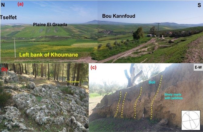
GEOGACETA, 70, 2021                                                              A. Amine, H. El Ouardi, M. Mazouar, M. Habibi and M. Boualoul

section when compared to the ridges           over highly dissected marls might be ex-          167, 103833 https://doi.org/10.1016/j.
(1070m-520m), where it is more pro-           plained by a cuesta or by the Khoumane            jafrearsci.2020.103833.
nounced (Fig. 2b). This flat area is well     fault scarp (Amine & El ouardi., 2017).          Amine A., El Ouardi H., Zebari M., El Makri-
highlighted by lower values of surface            The structural evolution of the South         ni H., Habibi M. (2020). Applied Compu-
roughness (SR =1) (Fig. 4). The rugged        Rifian Ridges show active structures ac-          ting and Geoscience. https://doi.or-
outcrops correspond to Plio-Quaternary        commodating the Southwestern motion               g/10.1016/j.acags.2020.100027.
detrital deposits (conglomerates and tra-     of the Rif belt with respect of stable Nubia     Andreani, L., Stanek, K.P., Gloaguen, R.,
vertines) (Figs. 2a; 5b).                     (Amine et al., 2020a) and are responsible         Krentz, O., Domínguez-González, L.,
    They are mostly accumulated in the        for the deformation through proximal              (2014). Remote Sensing 6, 7971–8001.
southeastern side of the basin (Figs. 5a),    basin development. It provides an expla-          doi:10.3390/rs6097971.
rise from the eastern folds towards the       nation of drainage network evolution,            Chalouan, A., Galindo-Zaldivar, J., Akil, M.,
centre, and then warped (Fig. 2a).            which was useful for the interpretation           Marin, C., Chabli, A., Ruano, P., Bargach,
    This movement correlates with the         of the Volubilis topography develop-              K., Sanz de Galdeano, C., Benmakhlouf,
deflection of the Khoumane river (Fig.        ment. The growth of folds controlled the          M., Ahmamou, M. and Gourari, I. (2006).
3a). The corresponding complex-sha-           drainage and tilting of plio-Quaternary           In: Tectonics of the Western Mediterra-
ped hypsometric curve (Fig.3b) indicates      deposits. The latter are remnants of flu-         nean and North Africa (G. Moratti y A.
two young phases in the Fert El Bir fold      vial sediments in the southern part of the        Chalouan, Eds.). Geological Society, Lon-
(Fig.1) (Amine et al., 2020a) and along the   basin and form a planation surface with           don, Special Publication 262, 101-118.
basin planation surface, which is argued      a cuesta morphology, instead of a plain          Faugères, J.C. (1978). Les Rides sud ri-
by active fractures affecting Quaternary      (El Graada plain (Fig.5a) that needs to be        faines, évolution sédimentaire et struc-
soil with Plio-Villa-franchian continental    studied in detail in future works.                turale d’un bassin atlanticomésogène
conglomerates (Fig.5c) that we interpret                                                        de la marge africaine. Thèse Doctorat
to be associated with the folds of the        Acknowledgement                                   d’Etat, Université de Bordeaux I.
western and eastern arcs of the South Ri-                                                      Grohmann, C.H. (2004). Computers &
fian Ridges. Their reactivation under Plio-       The authors thank Ruth Soto and an            Geosciences 30, 1055–1067.
cene shortening is still active in response   anonymous reviewer for their comments            Pérez-Peña, J.V., Azañón, J.M., Azor, A.,
to the Africa-Eurasia convergence (Cha-       and suggestions that greatly improved             2009a. Comput. Geosci. 35, 1214–1223.
louan et al., 2006; Amine et al., 2020a).     this paper. Our sincere gratefulness to          Roldán, F.J., Galindo-Zaldivar, J., Ruano, P.,
                                              Prof. Tamás Telbisz (Eötvös Loránd Uni-           Chalouan, A., Pedrera, A., Ahmamou, M.,
2 Swath profiles along the Khoumane           versity, Hungary) for all his help.               Constán, A. R., Sanz de Galdeano, C., Ben-
river.                                                                                          makhlouf, M., Lopez-Garrido,A.C., Ana-
                                              Referencias                                       hnah, F. and González-Castillo, L. (2014).
    Swath profiles show tilting of these                                                        Journal of Geodynamics 77, 56-69.
sediments coinciding with river warping       Amine, A., El Ouardi, H., (2017). Geogace-       Strahler, A. N. (1952). Geological Society of
to reach a recent course (maximum eleva-       ta 61, 71–74.                                    America Bulletin 63, 1117–1142.
tion = 400 m in Figure. 3c). The presence     Amine, A., El Ouardi, H., Zebari, M., El         Telbisz et al. (2012) Földtani Közlöny
of a young phase of rugged sediments           Makrini, H., (2020). J. African Earth Sci.       142/2, 193–200.

14                                                                           Cuaternario y geomorfología / Quaternary and Geomorphology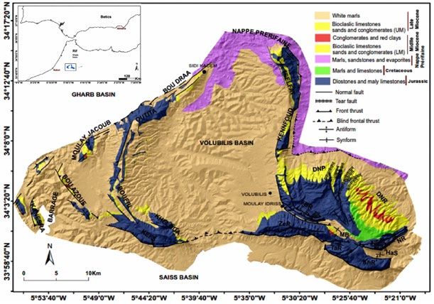
You can also read