TECHNICAL MEMORANDUM - City of Poulsbo
←
→
Page content transcription
If your browser does not render page correctly, please read the page content below
719 2ND AVENUE, SUITE 200 | SEATTLE, WA 98104 | P 206.394.3700

                            TECHNICAL MEMORANDUM
DATE:                  April 3, 2022
TO:                    Diane Lenius, City of Poulsbo
FROM:                  Alex Atchison, PE, PTOE
SUBJECT:               Oslo Bay Apartments – Frontage Improvements
PROJECT NUMBER:        554-2237-120
PROJECT NAME:          Oslo Bay Apartments

This memo summarizes Parametrix’s review of the “WSDOT Non-Motorized Mitigation Request” memo
from TSI, dated January 31, 2022. The memo challenges WSDOT’s recent request for non-motorized
improvements along the SR 305 frontage.
This memo discusses the need for active transportation frontage improvements, discusses how City policy
supports the requirement for frontage improvements, and how recent changes to WSDOT standards and
practices support frontage improvements.

EXISTING CONDITIONS

Roadway Conditions
SR 305 and SR307 are both designated by the Washington State Department of Transportation (WSDOT)
as Highways of Statewide Significance. HSS include interstate highways and other principal arterials that
are needed to connect major communities in the state.
 SR 305 is also defined by WSDOT as an “urban other freeway/expressway.” Between Viking Avenue and
Vetter Avenue, SR 305 is four lanes. South of Vetter Avenue, SR 305 widens to six lanes to accommodate
two turn lanes from southbound SR 305 to eastbound SR 307. The posted speed limit in the vicinity of the
project site is 40 mph. SR 305 has no sidewalks between SR 307 and Viking Avenue.
SR 307 is also defined by WSDOT as
“urban other principal arterial” east of SR
305 and “urban minor arterial” west of SR
305. SR 307 west of SR 305 is also
classified by the city as a “minor arterial.”
Near the project SR 307 is two lanes east
of SR 305, widening to five lanes at the
intersection with SR 305. SR 307 is three
lanes west of SR 305, also widening to five
lanes at the intersection with SR 305. The
posted spend is 35 mph. Sidewalks are
present on the Bond Road, on the south
side of the roadway, west of SR 305.
                                                       Figure 1: Northwest corner of SR 305/SR 307 intersection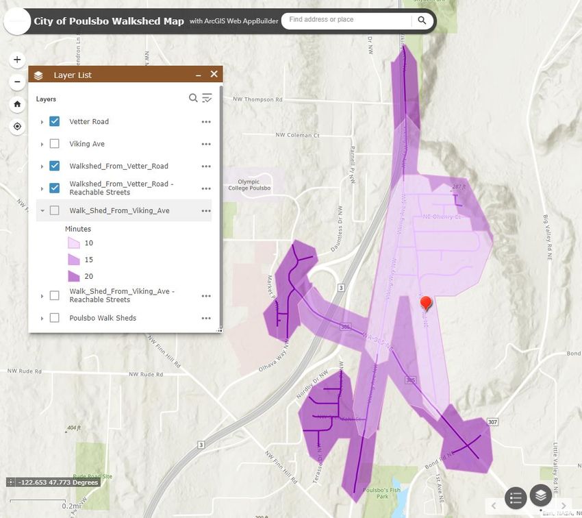
TECHNICAL MEMORANDUM (CONTINUED)

The signalized intersection of SR 305/SR 307 includes marked crosswalks on all approaches. There are
sidewalks around on the southeast and southwest corners of the intersection. No sidewalks exist on
northwest and northeast corners.
Additionally, the intersection of SR 305/SR 307 does not meet current WSDOT design standards for ADA
compliance or for Pedestrian Access Routes (PAR) as defined by the WSDOT Design Manual. The
minimum clear width of a PAR is 4 feet, exclusive of the width of the curb. On the northwest corner of the
SR 305/SR 307 interesction there is only approximately 2-3 feet between the fog line and the guard rail on
SR 307, as shown in Figure 1.

Crashes
SR 305, north of SR 307, has the highest traffic volumes and the highest number of collisions on all of SR
3051. Figures 2 illustrates the number of crashes along SR 305 between January 2012 and December
2016, as analyzed as part of the SR 305 Needs and Opportunities Study (Parametrix, 2017).

                               Figure 2: Crashes on SR 305 (January 2012 – December 2016)

1
    SR 305 Needs and Opportunities Study, Parametrix 2017

                                                                                                 554-2237-120
Oslo Bay Apartments – Frontage Improvements                 2                                     April 3, 2022
TECHNICAL MEMORANDUM (CONTINUED)

While no fatalties were reported along SR 305 during for the time shown in Figure 2, the high speeds
along SR 305 increase the risk for potential pedestri an and bicyclists fatalities. In Washington State, 86%
of pedestrian and bicyclist fatalities occurred on roads with posted speeds over 25 mph from 2010-2019.2
High vehicle speed greatly increase the risk of injury, as shown in below.

Providing dedicated, separated space for people bicycling and walking significantly reduces the likelihood
of fatal or serious injury crashes and as shown above is especially important where driver speeds are high.
The higher the speed the greater the separation needed for sidewalks, bicycle lanes, and crossing
facilities.

PEDESTRIAN AND BICYCLE DEMAND
Pedestrian counts at the intersections of SR 305/SR 307 and SR 305/Viking Way are low, but pedestrians
do use these intersections and walk along SR 305. Pedestrian and bicycle counts do not provide a
complete understanding of demand for active transportation facilities3.
Counts of pedestrians and bicycles do not account for barriers or places where this is a lack of active
transportation infrastructure. Or as TSI notes in their January 2022 memo, low volume of pedestrians can
be attributed to the fact the “current design does not support significant pedestrian volumes.” Existing

2 WSDOT. 2020. Active Transportation Plan, 2020 and Beyond. Available at https://wsdot.wa.gov/sites/default/files/2021-12/ATP-
  2020-and-Beyond.pdf . Accessed March 2022.
3 WSDOT. 2020. Active Transportation Plan, 2020 and Beyond

                                                                                                                 554-2237-120
Oslo Bay Apartments – Frontage Improvements                   3                                                   April 3, 2022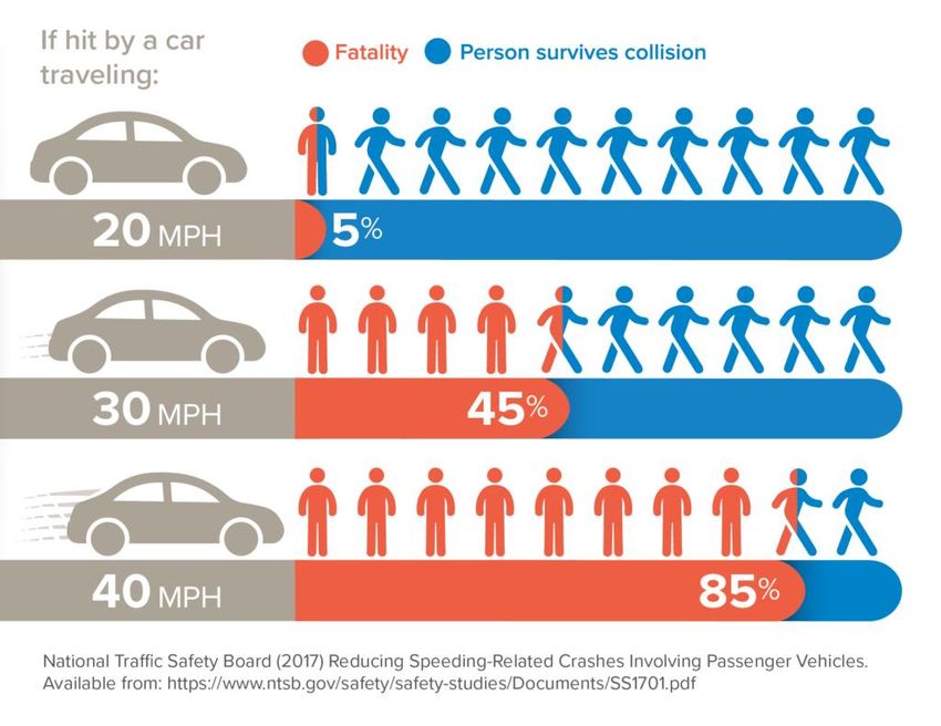
TECHNICAL MEMORANDUM (CONTINUED)

pedestrian and bicycle counts on SR 305 do not account for the level of traffic stress in a place that
discourages people who would otherwise use active transportation. Focusing on the data of people
already moving through a place does not account for “latent demand”. Latent demand refers to active
transportation use that would occur if safe, adequate facilities were provided. Latent demand can be
estimated by determining how many places are sited relatively near each other that people could walk or
bike to within a short time.
One method to estimate person trips is to use the Institute of Transportation Engineers (ITE) Trip
Generation rates. Using ITE’s trip generation data, the project is forecasted to generate 292 PM Peak
hour person trips, with approximately 5 percent (~15 trips) of these trips being walking trips. This would
equate to approximately 150 daily walking trips, assuming peak hour volumes account for approximately
10% of daily volumes similar to the ratio used when estimating daily vehicle volumes from peak hour
volumes.
For the most part, ITE’s trip-generation rates are based on data obtained at suburban locations that lack
good transit or bicycle and pedestrian facilities. The data does not capture latent demand. Not
surprisingly, studies indicate that these rates often significantly over-estimate the number of trips from
cars and trucks for land use projects located in areas near transit and within easy walking distance of
other land uses.
Improving conditions for active
transportation provides a positive feedback
loop, as shown below in Figure 3. A positive
feedback loop results from improving
conditions for walking and rolling. Facility
design and operational improvements reduce
crash exposure, leading to fewer collisions.
People feel comfortable and confident, mode
shift redistributes demand, and more active
trips result. Benefits include cleaner air and
water, improved health, and reduced VMT
(vehicle miles travelled), GHG (greenhouse
gases), crashes, congestion, and cost. These
benefits in turn improve conditions for
walking and rolling.
Providing frontage improvements along SR
305 and SR 307 would provide safe active
transportation connections to key existing
and bicycle networks and
commercial/medical areas within a 10-minute
walkshed of the proposed development. A
10-minute walkshed generally includes the
comfortable walking range of the average person.
                                                         Figure 3: Positive Feedback Loop from Improving Conditions
The intersections of SR 305/Viking and SR 305/SR
                                                         for Walking and Rolling
307 are within a 10-minute walkshed the project          (Source: WSDOT. 2020. Active Transportation Plan, 2020 and Beyond
site. Walkshed maps and key commercial/medical
areas within the walkshed are included in
Attachment A.

                                                                                                        554-2237-120
Oslo Bay Apartments – Frontage Improvements          4                                                   April 3, 2022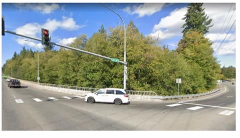
TECHNICAL MEMORANDUM (CONTINUED)

Key destinations such as the Bond Road Medical Center, Valley Nursery, Poulsbo Fish Park and its trails,
and the Dogfish Creek Trail entrance are all within a 10–15-minute walkshed of the project site and likely
to generate latent demand. Providing active transportation facilities between the project site and these
key destinations will improve safety and mobility for active transportation travel and is consistent with
the City’s plans for Complete Streets.
Given the number of businesses and recreational opportunities within a 10–15-minute walkshed of the
development, it is not unreasonable to assume there could be a latent demand of 10% or more (> 300
daily trips) that could be generated by the development occur if safe, adequate facilities were provided.

PROPOSED FRONTAGE IMPROVEMENTS
The frontage improvements required for the Oslo Bay Apartments include the following:
     •    An ADA compliant sidewalk and shoulder with adequate room for bicycles, or a shared use path
          for both pedestrians and bicyclists, along the entire SR305 frontage to the SR307 intersection
          through the radius and both pedestrian crossings – or approximately 1,850 linear feet of the full
          2,250 linear feet of frontage. It is anticipated that SR305 lanes may be shifted and/or narrowed to
          accommodate construction within the existing road prism.
     •     Other frontage improvements include standard curb and gutter, illumination, and stormwater
          infrastructure
     •    Frontage improvements are not required north of the SR307 curb return due to limited/no
          pedestrian destinations north of the intersection.
     •    Safety and frontage improvements at the SR305/SR307 intersection through the radius (curb
          return) by continuation of the ADA compliant sidewalk or shared use path to and transitions to a
          minimum 5’ wide shoulder beyond the curb return. Improvements are assumed to be within the
          existing roadway prism and anticipate shifting SR307 driving lanes eastward and/or narrowing
          lanes to safely accommodate the pedestrian/bike facility (either as sidewalk or shared use path),
          as well as curb ramps and relocated pedestrian crossing button pole.

CONSISTENCY WITH CITY AND STATE PLANS, POLICIES AND STANDARDS

The sections below describe in detail how the frontage improvements required for the Oslo Bay
Apartment development are consistent with both City and State plans and standards.

City of Poulsbo Plans, Policies and Standards
Requiring active transportation frontage improvements for the Oslo Bay Apartment development along
SR 305 and SR 307 is not only consistent with City standards, but also consistent with City adopted plans.

Urban Paths of Poulsbo
The Urban Paths of Poulsbo (UPP), approved by City Council in May 2019 identifies proposed priority
projects throughout the city, including a proposed shared use path through the proposed Oslo Bay
development site, connecting to the intersection of SR 305/SR 307 (see Attachment B.) In addition, the
UPP identifies the need for safe pedestrian routes “on both sides of the SR 305 highway, noting in part,
that the medical offices at SR 305/Bond Road are a destination with poor pedestrian access.” Having the
applicant provide frontage improvements along SR 305 and SR 307 would be consistent with current
adopted City priorities for urban paths.

                                                                                                  554-2237-120
Oslo Bay Apartments – Frontage Improvements           5                                            April 3, 2022
TECHNICAL MEMORANDUM (CONTINUED)

Adopted Comprehensive Plan
Multiple policies in the City’s Comprehensive Plan support the requirement for frontage improvements
along SR 305 and SR 307, including the following goals and policies laid out in Chapter 4: Transportation.
     Policy TR-1.2 The City shall require that all streets – new construction, retrofit or reconstruction – be
     complete streets, built to accommodate as appropriate all travel modes in compliance with the City’s
     design standards and plans for streets, bicycles and pedestrian facilities and safety elements.
     Policy TR-1.4 Each new development in the City shall mitigate its traffic impacts by providing safety
     and capacity improvements to the City’s transportation system in order to maintain the adopted level
     of service on transportation facilities and to provide for the safe and efficient movement of people
     and goods using multiple modes of travel.
     Policy TR-4.1 Ensure high safety standards for motorists, pedestrians, and bicyclists through the
     development and capital improvement processes. The City will evaluate safety conditions on City
     roadways, including pedestrian and bicycle conditions, every six years, in conjunction with the six-
     year transportation improvement plan, to determine whether improvements should be made. If
     safety-related improvements are identified, the improvements should be included in the
     Transportation Improvement Program for timely construction.
     Policy TR-5.1 Develop and maintain an interconnected and overlapping transportation system grid of
     pedestrian walkways, bicycle facilities, shared use paths, roadways for automobiles and freight, and
     transit service. The system should increase safety and mobility, facilitate mode integration and
     intermodal connections, improve access to local centers and provide increased opportunities for
     healthy activities and alternatives to driving.
     Policy TR-6.1 Design transportation infrastructure in urban areas to support compact, accessible and
     walkable neighborhoods that support transit and integrate multi modal transportation options.
     Policy TR-6.2 Improve connectivity of neighborhoods and commercial areas by planning an integrated
     grid of public paths, bikeways and complete streets that connects to existing and future parks,
     shopping, healthcare, residential and commercial development.
     Policy TR-8.4 Coordinate City transportation planning and capital project development and
     implementation with Kitsap County, Kitsap Transit, WSDOT and non-motorized advocacy groups to
     ensure that City plans, and projects connect and reflect regional transportation system networks,
     goals and needs.
     Policy TR-9.1 Coordinate City transportation planning and capital project development and
     implementation with Kitsap County, Kitsap Transit, WSDOT and non-motorized advocacy groups to
     ensure that City plans, and projects connect and reflect regional transportation system networks,
     goals and needs.
     Policy TR-9.2 Require pedestrian facilities on all public streets that provide safe transportation for
     users of all ages and abilities, including most vulnerable users such as children, elderly and the
     disabled.
     Policy TR-9.2 Require pedestrian facilities on all public streets as set forth in the City’s Construction
     Manual Street Standards. Alternative pedestrian facilities that meet or exceed the minimum street
     standards may be considered by the City and are subject to approval by the City Engineer
The Transportation Plan Update (2016), Section 6.1.1: Planned Improvements, identifies the
requirements for sidewalks on City streets.

                                                                                                      554-2237-120
Oslo Bay Apartments – Frontage Improvements             6                                              April 3, 2022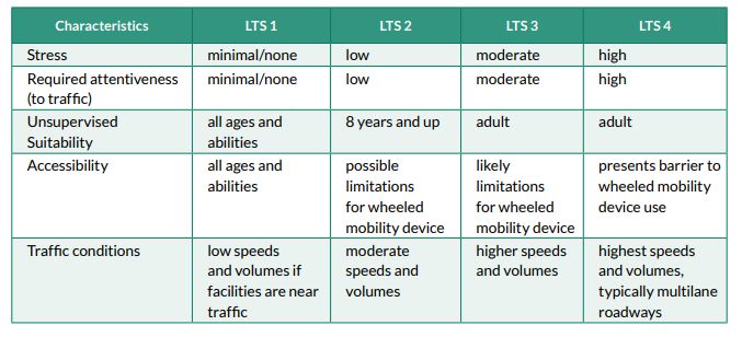
TECHNICAL MEMORANDUM (CONTINUED)

     Most of the road segment improvements consist of adding turn lanes, median lanes, sidewalks, and
     bicycle lanes. Some roads will also require reconstruction of obsolete pavement. A significant
     emphasis is placed on completion of sidewalks to satisfy the proposed segment-based LOS policy.
     Without sidewalk improvements on many streets, the additional traffic impacts caused by new
     developments would create unsafe conditions for pedestrians. The City’s design standards require
     sidewalks on all roads. The segment-based LOS policy enforces the requirement to add sidewalks on
     older rural roads as a condition for carrying the increased volumes due to urban growth.
Additionally, the City’s Comprehensive Plan supports the Urban Paths of Poulsbo through its goals and
policies laid out in Chapter 8: Park, Recreation and Open Space:
     Policy PRO- 4.1 Use the Urban Paths of Poulsbo Plan and maps to identify and prioritize
     implementation strategies and key acquisition and development opportunities for connections
     supporting nonmotorized travel. Prioritize these connections in the City’s 6-Year Capital Improvement
     Program, which is reviewed annually.
     Policy PRO-4.2 Use a multi-faceted approach to implement the Urban Paths of Poulsbo Plan. As set
     forth in the UPP plan, the implementation strategies should include:
     •    Reviewing the city’s municipal code to incorporate standards for pedestrian and bicycle facilities,
          bicycle parking, and incentives for developers who provide connections for walking, cycling and
          other forms of non-motorized travel.
     •    Coordinating with the Planning Department to look for opportunities for non-motorized linkages
          during the development review process.
     •    Working with Homeowners’ Associations to identify prospective paths in their subdivisions to
          connect the neighborhood to outside routes.
     •    Seeking partnerships with other jurisdictions, private businesses, non-profit organizations, the
          development community, and citizens to realize the UPP vision
     •    Working with the City Engineering Department to consider and evaluate the UPP plan, maps, and
          implementation list in the planning, design, construction, and maintenance of roadway projects.
     •    Establishing maintenance and preservation standards and ensuring adequate funding is available
          for maintenance and preservation of trails in parks and on-street facilities.
     •    Reviewing existing policies for non-motorized users and coordinating with the Police Department
          to ensure adequate enforcement for public safety.

Complete Streets Ordinance 14.06
The City’s Complete Street Ordinance (14.06.030 Project Planning) states that “Particular attention should
be given to projects which have the opportunity to enhance the overall transportation system and its
connectivity for access to parks or recreation areas, schools, shopping/commercial areas, government
facilities, public transportation, employment centers, existing pedestrian or bicycle networks, or regional
bicycle pedestrian plans prepared by other associated groups” (emphasis added).

City of Poulsbo Construction Standards and Specifications

Appendix B – Terms and Conditions for Development of the City’s Construction Standards and
Specifications sets forth that the City Engineer can require frontage improvements.

                                                                                                   554-2237-120
Oslo Bay Apartments – Frontage Improvements            7                                            April 3, 2022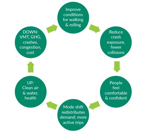
TECHNICAL MEMORANDUM (CONTINUED)

WSDOT Plans, Policies and Standards

Active Transportation, 2020 and Beyond
Requiring active transportation improvements on SR 305 and SR 307 is consistent with WSDOT’s goals to
“build and maintain a transportation system that serves every person.”4, as detailed in their Active
Transportation Plan, 2020 and Beyond. The plan notes that “active transportation must be a core element
of an integrated, sustainable, resilient, healthy, and just multimodal transportation system.”
The plan acknowledges that given the rapid growth along and around highways, hundreds of miles of
state routes now function as the as primary community streets with associated needs for design suitable
to local short trips. This holds true for SR 305 and SR 307 and supports the need for frontage
improvements that provide safe, adequate active transportation facilities.
To evaluate the quality of active transportations on state roadways, WSDOT uses a metric called level of
traffic stress (LTS). LTS uses available roadway characteristics data, such as posted speed and number of
travel lanes, to give the roadway segment a LTS score. Figure 45 below, illustrates the characteristics
associated with level of stress. Based on the posted speeds, high volumes and number of lanes, SR 305
and SR 307 would be categorized as LTS 4. Roadways with LTS 4 are not likely to appeal to very many
people who want to bike or walk. WSDOT identifies highway locations with high LTS (LTS 3 or 4) as gaps in
the active transportation system. Frontage improvements on SR 305 and SR 307 will address these gaps.
Figure 4: Characteristics associated with level of traffic stress (LTS)

Target Zero
Frontage improvements along SR 305 and SR 307 also support WSDOT’s “Target Zero” plan. “Target Zero”
is WSDOT’s strategic highway safety plan with the goal to reduce the number of traffic deaths and serious
injuries on Washington’s roadways to zero by the year 2030.

4
    WSDOT. 2020. Active Transportation Plan, 2020 and Beyond. Available at https://wsdot.wa.gov/sites/default/files/2021-
      12/ATP-2020-and-Beyond.pdf . Accessed March 2022.

5
    Figure 3-10 from WSDOT ATP 2020 and Beyond

                                                                                                                    554-2237-120
Oslo Bay Apartments – Frontage Improvements                     8                                                    April 3, 2022
TECHNICAL MEMORANDUM (CONTINUED)
The posted speed limit on SR 305 is 40 mph and the posted speed limit on SR 307 is 35 mph. Studies show
that when a motorist hits a pedestrian at 20 mph, the pedestrian has 95 percent chance of survival versus
only a 15 percent change at 40 mph6. The proposed development is likely to be a pedestrian generator
(see section below) fronting the section of SR 305 with the highest traffic volumes and highest number or
crashes, and therefore to improve safety, the frontage improvements required by the city are necessary.
Frontage improvements specifically support two of the key Target Zero strategies:
• Lack of separated infrastructure and incomplete networks “Providing appropriately designed,
functional, and complete pedestrian networks may reduce the potential for active transportation
crashes. Comparison of places with and without complete networks provides evidence that having
continuous connections and separated facilities reduces crashes; providing separated bicycle
facilities in cities reduces potential for crashes of every mode.”
• Speed control and separation “Where lower speeds are not possible, this principle encourages
greater separation between vulnerable users and vehicular traffic. Where permitted speed limits
are higher, more separation is called for so vulnerable road users are not in spaces right next to
high-speed traffic.”
Practical Solutions
As noted earlier, WSDOT identifies highway locations with high LTS (LTS 3 or 4) as gaps in the active
transportation system. WSDOT intends to address these gaps using the Practical Solutions approach to
arrive at the best treatments for the partners, budget, and other constraints in a location. The Practical
Solutions model represents WSDOT’s approach to selecting the right project or solution, for the right
location, at the right time.
WSDOT notes that specific changes on state roadways that provide a safer and more complete
multimodal facility depends on local plans and conditions, available right of way, availability of parallel
lower-stress facilities, and other variables. As there are no parallel lower-stress facilities near the
proposed development site, safe and accessible active transportation facilities should be provided along
the development’s frontage. Providing sidewalks or a shared use path along SR 305 and SR 307 would
improve safety and lower level of stress. Also, since these improvements could be constructed within the
roadway prism, they align with the Practical Solutions approach.
WSDOT Design Manual
The general purpose of any roadway design standards it to provide standardized road design and
construction elements for consistency and to ensure, so far as practical, that minimum requirements of
the motoring public are met. These requirements include safety, convenience and economical
maintenance.
WSDOT’s Design Manual guidance is provided to encourage the statewide uniform application of design
details under normal conditions. It also guides designers through the project development process used
by WSDOT. The Design Manual (DM) is used by the department to:
• Interpret current design principles, including American Association of State Highway and
Transportation Officials (AASHTO) and other appropriate policy sources, findings, and federal and
state laws.
6
WSDOT Target Zero 2019
554-2237-120
Oslo Bay Apartments – Frontage Improvements 9 April 3, 2022TECHNICAL MEMORANDUM (CONTINUED)
• Develop projects that address modal and community performance needs.
• Balance the competing performance needs of highway construction projects.
• Design for low-cost solutions.
1510 Pedestrian Facilities
Since the frontage improvements for the Oslo Bay Apartments, required by the Poulsbo City Engineer, are
along state highways, they must meet WSDOT Design Standards for both pedestrians and ADA
requirements. The frontage improvements would be considered an alteration project and will need to
meet the requirements as set forth in the DM Chapter 1510.
1130 Development Services
WSDOT recently retired the Development Services Manual and added it as a chapter to the Design
Manual. Much of the DSM’s content informed the new chapter of the DM and forthcoming guidance
documents. WSDOT states on their website “The DSM was outdated. As we began to look at resourcing
that, we decided to instead create a new DM chapter containing the policy and main direction. By
including this as a Design Manual chapter, it stands with other DM policy chapters such as TIAs, Access
Control, Driveways, Intersections, commonly used for design and facilitation of development mitigation.
Changes to the guidelines for Development Service reflects WSDOT’s changes in policy toward active
transportation facilities along state highways. WSDOT, in recent years, has been more open and willing to
accept adjustments to lane widths as a trade-off for the ability to provide safe and comfortable
infrastructure for walking and rolling, to balance the competing needs of the highway system.
“WSDOT’s goal is to provide a safe, sustainable, and integrated multimodal transportation system for all
Washington travelers, regardless of age, ability, income, ethnicity, or mode of transportation. Added
automobile trips to and from new development often result in impacts to the transportation system which
can be costly to mitigate while also inducing more auto-based travel. WSDOT encourages partners to
promote solutions that better support multimodal options. Development that supports access by walking,
bicycling, and transit is essential towards reaching this goal.”
1130.09(2) WSDOT’s Role in Development Review
WSDOT’s authority to review land use proposals and request or require mitigation is founded in state law,
specifically the State Environmental Policy Act, the Growth Management Act, and through our state
managed and limited highway access connections laws, policies and procedures.
• WAC 197-11-920 regards WSDOT as possessing special environmental expertise relating to
transportation; and as an agency with expertise in the local development review process similar
to local and state water, sewer, or fire protection agencies.
• As an agency that possesses special expertise in the state transportation system, WSDOT has
established standards, policies, and mitigation thresholds for system function, safety, and
performance, particularly for driving trips.
• These standards, policies, thresholds, and local approval criteria are applied to the applicant’s
development proposal to form WSDOT’s mitigation recommendations to the local government.
When developers request connections to the state system, WSDOT may require improvements to
the transportation system as a condition of issuance of a highway access permit. Any such
requirement must be appropriate and reasonable to mitigate the impact to the transportation
system resulting from the development.
554-2237-120
Oslo Bay Apartments – Frontage Improvements 10 April 3, 2022TECHNICAL MEMORANDUM (CONTINUED)
• In other cases, WSDOT works with the lead agency and developer to request recommended
development mitigation that is appropriate and reasonable.
• The responsibility for a land use decision is with the local governing body. Like other interested
parties, when there is legal standing, WSDOT can appeal the local land-use decision.
1130.09(2)(f) Active and Public Transportation
Both active transportation and transit provide essential travel options for those who do not choose to or
who cannot drive themselves. Work with the developer, tribe, or lead agency to evaluate active and public
transportation system impacts and needs to determine mitigation that provides safety, mobility, and
accessibility for all users of the multimodal transportation system.
• Review the TIA, SEPA document, Lead Agency and WSDOT planning documents, including the
state Active Transportation Plan.
At that time of WSDOT’s previous review, in early March 2021, WSDOT had not analyzed a proposal to
adjust lane widths on SR 305. Requiring frontage improvements without reducing lane widths would have
extended sidewalks outside of the existing roadway prism.
Since that time, the City of Poulsbo engineering team has provided a proposal that provided for
pedestrian improvements within the roadway prism. The proposal includes narrowing lanes on SR 305.
WSDOT has agreed to narrower lanes on SR 305, allowing for the frontage improvements to be
constructed within the roadway prism. Narrowing the lane widths on SR 305 also increases the likelihood
of lower speeds7, increasing safety for active transportation users even more.
CONSISTENT WITH PROJECT NARRATIVE
The Oslo Bay Apartments Site Plan Review Narrative (October 2021) make several mentions of providing a
connected pedestrian and bicycle network on site.
• Page 1: one of the key elements of the 49.1-acre development is to “maximize pedestrian
accessibility and circulation through the apartment site.”
• Page 2: the site will have “extensive network of sidewalks and pedestrian paths.”
• Page 33. “Walkways and trails have been designed to provide pedestrian connectivity throughout
the entire site, linking site amenities areas, residences, shared community resources, and
providing residents with a walking/running/hiking circuit as well as physical and visual
connections to the adjacent forested and scenic areas.”
• Page 34: “Bike parking (in addition to that provided in building breezeways) and benches are also
provided throughout the site, along the pedestrian pathway network.”
• Page 36: “PMC 18.140.060 - Design Standards for Bicycle Parking Areas requires two bicycle
spaces plus one additional space for every twenty automobile parking spaces, with no more than
20 bicycle spaces required. This project proposes 850 automobile parking stalls (Section V.A.21)
which equates to 43 bicycle spaces. However, given the scale of this project, the applicant
proposes to exceed this standard by providing 100 outdoor bike spaces as follows: 3 spaces per
7 FWHA ” USE OF NARROW LANES AND NARROW SHOULDERS ON FREEWAYS: A PRIMER ON EXPERIENCES, CURRENT PRACTICE, AND
IMPLEMENTATION CONSIDERATIONS https://ops.fhwa.dot.gov/publications/fhwahop16060/ch4.htm
554-2237-120
Oslo Bay Apartments – Frontage Improvements 11 April 3, 2022TECHNICAL MEMORANDUM (CONTINUED)
buildings (39), 47 spaces for recreational amenities, and 14 spaces for the community
building/pool).”
Additionally, the TIA states on page 34 that the project “will increase demand for nonmotorized trips
associated with commuting to work, accessing services.” The applicant is clearly expecting active
transportation use to increase as result of the proposed development. Frontage improvements that
provide safe, adequate active transportation facilities are necessary.
CONCLUSION AND RECOMMENDATIONS
• The existing conditions along SR 305 and at the SR 305/SR 307 intersection do not provide for
safe, comfortable, accessible active transportation uses.
• The project is expected to generate increased vehicle and active transportation trips. Regardless
of the existing pedestrian counts along SR 305, there is a latent demand for active transportation
facilities, as noted in the Oslo Bay Apartment TIA and the Site Plan Review Narrative.
• Any increase in active transportation trips along SR 305 increases the potential for pedestrian
fatalities, especially given the high posted speed on the highway.
• Frontage improvements that improve conditions for active transportation will create a positive
feedback loop and increase demand for the facilities. Facility design and operational
improvements reduce crash exposure, leading to fewer collisions. People feel comfortable and
confident, mode shift redistributes demand, and more active trips result.
• Frontage improvements that include safe, accessible active transportation facilities within the
existing roadway prism will increase safety by providing separated facilities, reducing the
likelihood of fatal or serious injury crashes.
• Active transportation facilities along SR 305 have been identified in the City’s adopted
Comprehensive Plan. Providing frontage improvements, as laid out by the City Engineer is
consistent with City plans.
• Frontage improvements that include active transportation facilities are consistent with the City’s
goal of creating Complete Streets, the City’s Comprehensive Plan, WSDOT’s Active Transportation
Plan, 2020 and Beyond, WSDOT’s Target Zero plan, WSDOT’s Practical Solutions Approach and
the WSDOT Design Manual.
• SR 305, north of SR 307, has the highest traffic volumes and the highest number of collisions on
all of SR 305. Narrowing the travel lanes on SR 305 to accommodate the frontage improvements
will have an additional benefit of lowering speeds, further improving safety for active
transportation users and those driving vehicles.
554-2237-120
Oslo Bay Apartments – Frontage Improvements 12 April 3, 2022ATTACHMENT A
Walk-Time Maps
Walk-time maps – the walking version of drive-time area maps – were created using ArcGIS Online to
show where and how far pedestrians can travel in a certain amount of time. Walk-time maps are based
on a predefined walking speed of 3 miles per hour (mph) and existing paths and roads that allow
pedestrian traffic.
Two separate walk-time maps were created and are described in more detail below.
Walk-time distance from Sonic Drive-In on Viking Way
• Conservative assumption of how far the walksheds would extend to the west and south from
the project site. The Sonic Drive-in is located near the west end of the project site
• Walkshed assumes existing street system; Vetter does not connect with SR 305.
• With the connection of Vetter Road to SR 305, the 10-minute walk shed from the project site
will extend beyond SR 305/SR 307 (Bond Road) intersection, and the 15-minute walkshed will
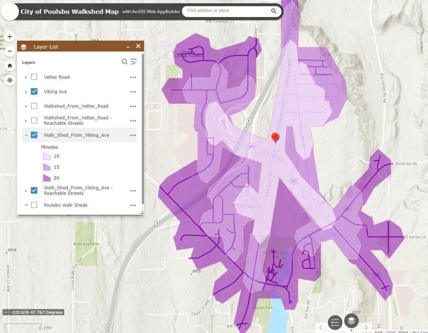
likely extend to the intersection of SR 305/Forest RockWalkshed distances from 21466 Vetter Rd NW
• Existing house located on Vetter Road, north of proposed Road L
• Conservative assumption of how far the walksheds would extend to the west and north from
the project site.
• Walkshed assumes existing street system; Vetter does not connect with SR 305. All walking trips
from this point must use Viking Ave to access SR 305.
• With the connection of Vetter Road to SR 305, the 10-minute walk shed from the project site
will extend beyond SR 305/SR 307 (Bond Road) intersection (see walk-sheds from Sonic Drive-
in).Key commercial/retail businesses within the walksheds
Distances from Road A intersection with Vetter, using Vetter extension to SR305, then along SR 305 to
SR 307/Bond Road – includes approximately 700’ distance from Road A intersection (near clubhouse) to
SR305:
2,200’ (0.42 mi) to Bond Road Medical Center
• Urgent Care
• Birthing Center
• Eye care/surgery
• NK Medical Center
• Attention Deficit Disorder treatment
• Dentist office (across Bond)
2,400’ (0.45 mi) to Valley Nursery
2,500’ (0.47 mi) to Dogfish Creek Trail entrance on Bond
2,700’ (0.51 mi) to Business park on SR305 adjacent U-Haul/NK Self-Storage
• Crossfit
• Twisted Chiropractic
• Storehouse Church
• DME Auto
• Kitsap Hot Yoga
• Next Day Dry Cleaners
• Tattoo shop (couldn’t read actual name)ATTACHMENT B
Urban Paths of Poulsbo Proposed Priorities
Legend
City Limits
Urban Growth Area
Existing Trails
Proposed Trails
Dedicated Striped Bicycle Lanes
Existing Sidewalks One Side
Existing Sidewalks Both Sides
Shared Use Path
OC/
WWU Proposed Shared Use Path
Vinland
E.S. On Street Link
Conceptual Future Road Locations
U Park and Ride
Transfer Center
E
U
G AV
Transit Center
VIKIN
W W
j
k Sound to Olympics Trail Connection Point
Y
X Liberty Bay Viewpoint
FI
Public Facilities
NN
HI
LL
Parks
Schools
Fish Park
ST
Poulsbo
AT
j
k
E
Pump Track
HW
Forest Rock
BOND RD
Y
Hills Park
30
RD
5
NE
LN
U
CO
LIN
Betty Iverson
U Kiwanis Park
U FO
R OCK
ST L N
RE
Nelson Park
10TH AVE
4TH AVE
Parks &
Recreation
E
AV
ING
RD
VIK
LN
U CO
NOLL RD
LIN
IVERSON ST
American Legion
Park Centennial
Park
FR
O
City
NT
Hall
ST
Wilderness Park
NKHS
HOSTMARK ST
U
Muriel Iverson Williams
Waterfront Park
X
Y PMS
6TH AVE
Poulsbo
STATE HWY 305 NE
Net Shed Austurbruin E.S.
Vista Park
FJO
RD
Frank Raab Park
D
Lions
R
Park
NOLL RD
Oyster Plant
The Urban Paths of Poulsbo Plan and maps serve as the 20-year
vision for trial acquisition and development. The UPP Plan is included
as Appendix B-6 of the Comprehensive Plan. Figure PRO-3 map the X
Y
20-year vision for trails in the City, as identified in the plan. Trails and
non-motorized connections are conceptual; actual alignment may vary
based on topography, property owner-ship and willingness, or other
variable. The City will only work with willing property owners. Projects
will be prioritized through the 6-Year CIP.
µ
This map is intended for general purposes. Maps are
Created by
schematic representations of physical features,
City of Poulsbo GIS
infrastructure, and land ownership boundaries.
August 2018
The information was derived from available public records
and existing sources, not from surveys.You can also read