Submission of feedback for the Townsville City Centre to James Cook University Cycleway Planning project
←
→
Page content transcription
If your browser does not render page correctly, please read the page content below
Submission of feedback for the Townsville City Centre to James
Cook University Cycleway Planning project
Segment 1: Townsville City Centre (between Denham Street and Mindham Drain)
Denham Street to Stanley Street has very limited space for bicycle infrastructure. The
plan should consider making this section of Flinders street a shared zone with reduced
speed limits, ample signage, and ‘decorative’ road treatment to indicate to motorist they
are in a heavy pedestrian area and encourage more mixed use of the Road and verge for
businesses. For example: South Terrace, South Fremantle WA (see photo at end of
document).
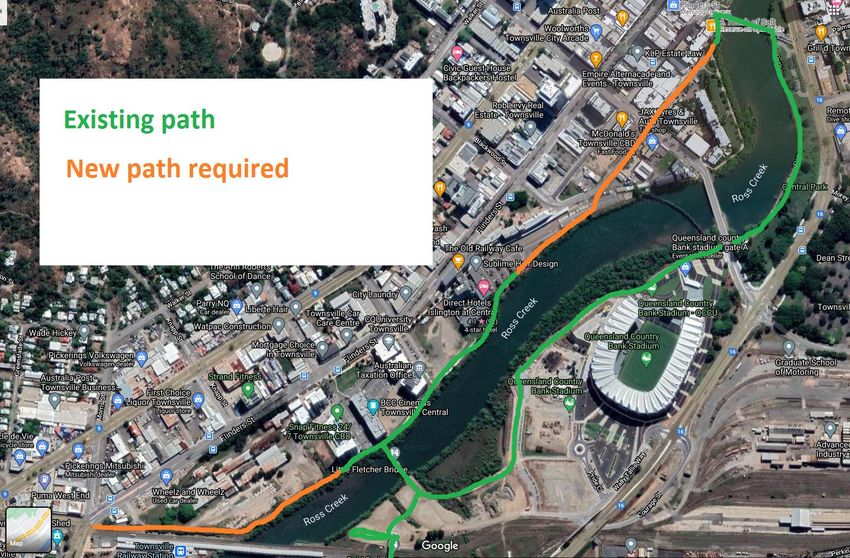
Alternatively there is an incomplete shared path running along the Northern Bank of
Ross Creek from Little Fletcher Street to behind the Former Townsville Railway Station.
This could be extended to the east along the Creek to the intersection of Charters Towers
Road and Flinders Street. Westerly it could be continued along Hanran Street to link to
Flinders Mall (Stokes Street) and Victoria Bridge (pedestrian/bicycle bridge). See
appended map at end of document. This would be a good option to explore and may help
activate the Creek for the benefit of bicycle riders, walkers, joggers, and encourage
increased foot traffic to restaurants and cafes the vicinity. It would also nicely complete
the path network associated with the Townsville Stadium development.
Road intersections on Charters Towers Road at Ingham Road and Woolcock Street are
dangerous for bicycle riders and need upgrading.
The off-road path on Western side of Charters Towers road between Ingham Road and
Woolcock Street needs upgrading. Too narrow and numerous metal grates and uneven
surfaces, especially at the bridge over the Ross Creek channel. The Ramps at both the
northern and southern end of this section are poorly designed.
Note that ‘(arrow symbol) all bicycles’ sign situated at the intersection of Woolcock
Street and Charters Towers Road is purely a guidance sign and does not relate to any
enforceable Australian Road Rule. We object to the use of this sign as it falsely gives the
impression to motorists that bicycle riders are not allowed to, or are even prohibited
from, riding on a stretch of road immediately following these signs. We have numerous
anecdotes from Townsville bicycle riders being honked at and abused in close proximity
of these signs. Hence, we believe that the use of these signs in North Queensland is
detrimental to the ‘sharing the road’ ideal promoted by both TMR and TCC.
Segment 2: Mindham Drain (between Woolcock Street and Balls Lane)
This are is subject to regular inundation during the wet season. It is a drainage line
servicing surrounding suburbs – essentially a tributary to Ross Creek. Shared path
facilities need to be designed in a way that they are elevated above flood level so that the
path is usable year round, including during periods of rainfall.
There are five major road crossings along this 4 km section: Woolcock Street, Bayswater
Road, Bayswater Terrace, Townsend Street, and Balls Lane. These are busy arterial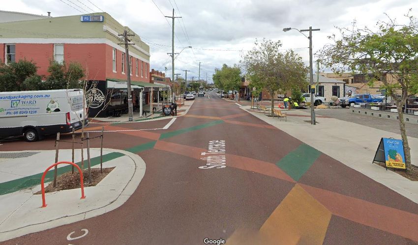
roads and both dangerous and difficult to cross. The design of the cycle network needs to
address this by applying sufficient signalling to allow bicycle riders and pedestrians to
cross. Alternatively a road treatment which both slows traffic alerting them to
bicycle/pedestrian activity and allows bicycle riders and pedestrians to cross freely. A
large central pedestrian island with sufficient space for multiple bicycles to occupy the
space at any one time.
Segment 3: Anderson Botanic Gardens and Wellington Street
I imagine this will be a very pleasant section to ride. Will there be a separated shared
path on the northern side of Wellington Street?
Segment 4: Gulliver Street
Separated shared path on the eastern side of Gulliver Street would be welcomed. School
students currently ‘Salmon’ along this section of road in the morning to get to Pimlico
State High School (To salmon = riding against the flow of traffic)
Improved intersection design required at the Ross River Road intersection
Segment 5: O’Reilly Street to Aplins Weir
This section currently has a dedicated off-road shared path but is regularly blocked by
residents using the shared path to conveniently park their vehicles on and hence deemed
unusable for bicycle riders. The stretch also has a number of minor road crossings which
need on-road treatment to delineate the cycle path having right of way over traffic on the
secondary road. i.e. giveway sign set back from intersection, sufficient warning signage
for motorists, raised treatment (priority crossing), and on-road green painting. The
intersections along O’Reilly Street which are impacted are Swales Street, Farrah Street,
Brownhill Street, and Lynd Street. The end of O’Reilly Street needs to have
raised/painted road treatment (priority crossing) to connect O’Reilly Street Shared Path
to the Ross River Shared Path.
Segment 6: Off-road corridor within Annandale (between Aplins Weir and University
Road)
This section is mostly existing shared path. There are some issues with sections of the
path 1) being damaged by tree roots, and 2) poor drainage where short sections are
covered by water and sediment for far longer than necessary (i.e. days to weeks
following rain). This should be an easy fix with some minor drainage improvements. I.e.
adjacent to Maribou Drive and Magnolia Circuit.
The crossing at Yolanda Drive needs enlarging and more visible signage and road
treatment for motorists. Suggest a mid-block priority crossing. Poor drainage of the Southern entry of the Douglas Arterial Road underpass needs to be
addressed (easy fix would be to drain water into adjacent creek).
The creek ford directly west of the underpass needs a bridge. This ford remains wet for
much of the wet season, and flow across the ford can be significant during rainfall
events.
Additional comments
Charters Towers Road and Ross River Road will remain the most direct route for
commuter cyclists and should be included in the scope of this study. The intersection at
charters towers Road and Ross River Road needs upgrading to provide a safe right turn
option for bicycle riders. The southbound on-road cycle lane abruptly ends 200m from
the intersection and bicycle riders are thrown into the mix of kerbside parking, a left
turning lane, and the task of merging across two lanes in flowing 60km/h traffic to
continue their ride onto Ross River Road. Motorists are impatient at this intersection.
Expected users include parents escorting primary school age children (10 – 15 km/h),
high school students (15 – 25 km/h), and commuter cyclists (20 – 35 km/h). Design of
the path should allow for that range of bicycle speeds. For example unnecessary tight
angled turns should be discouraged, while gentle curves create a nice riding experience.
Squeeze points such as ‘banana barriers’ should also be discouraged. For example the
gauntlet of banana barriers at the Aplins Weir bridge are a pain in the arse. Vertical
bollards sufficiently excludes vehicles from the path and do not create a constriction.
Banana barriers are also difficult to see under reduced visibility (low light, night-time,
rain storms).Figure 1. Possible extension (orange) of existing path (green) along Ross Creek to link Denham Street to
Charters Towers Road (Section 1)
Figure 2. Painted road treatment in a high traffic pedestrian area on South Terrace, Fremantle WA. An added
benefit was that it made the street more pedestrian friendly for businesses and cafes.
https://www.google.com/maps/@-
32.0680843,115.7525571,3a,75y,357.95h,90t/data=!3m6!1e1!3m4!1sRfuW3Dzy8juLJcp2vGSJag!2e
0!7i16384!8i8192Townsville Principal Cycle Network
Townsville City Centre to James Cook University
The Department of Transport and Main Roads is Key features
undertaking planning to make bicycle riding an A well-designed bicycle network needs to be visible,
easy, safe and enjoyable way to travel between intuitive and provide bicyle riders with connections
the Townsville City Centre to James Cook between destinations, the key features for this project will
University. include:
• A new direct, continuous route with limited
Overview intersections to encourage bicycle riders of all
The Townsville City Centre to James Cook University abilities to use the facility.
Cycleway Planning project establishes a long-term vision • A route plan ready for design development.
to provide a fit-for-purpose, interconnected safe bicycle
• A clear understanding of possible issues and
route between the Townsville City Centre to the University
mitigation.
Drive underpass.
• An understanding of stakeholder concerns and
The proposed route will provide safer and improved expectations.
connections for bicycle riders to educational facilities,
health services, businesses, sports and recreational
centres, and shopping precincts in Townsville. Timeframes
The project is part of a group of active transport projects
funded by the Queensland Government within the
Townsville region.
The Townsville City Centre to James Cook University
Funding Cycleway Planning project is currently in the planning
The Townsville City Centre to James Cook University phase.
Cycleway Planning project is funded under the Transport
and Main Roads Transport System Planning Program Activities include concept development, environmental
and is for planning only. Any future funding will need to scoping, engineering investigations, cost estimating and
compete against other state-wide priorities. community consultation.
Transport and Main Roads understands the importance TMR is undertaking an Options Analysis to develop the
of this project to the local community and will look preferred corridor solution as shown in the project map
for opportunities to progress this project through overleaf. It is anticipated that the Options Analysis will be
development and delivery. completed by late-2021.
Benefits Have your say
Transport and Main Roads recognises that more trips Consultation is underway and we are seeking your feedback
made by bicycle riding will result in a more balanced from 8 March 2021 to 20 April 2021.
transportation system that supports a healthy and
liveable community. On average, every dollar invested Your feedback will help us to better understand the priorities
in bike riding infrastructure will return nearly five dollars and experiences of bicycle riders in the area and what is
in economic benefit to Queensland with improved health important to the community.
outcomes, reduced traffic congestion and low transport For more information about the Townsville City Centre to
costs. Other benefits are; James Cook University project:
• Improved safety for people riding bikes Contact us
• Better active transport connection Phone: 1800 625 648*
• Improved bike riding quality During business hours, Monday–Friday
Email: engagement.northern@tmr.qld.gov.au
• More people riding provides additional opportunity
Web: www.tmr.qld.gov.au and search ‘Cycling Strategies’
for a sense of community and connection.
* Free call from anywhere in Australia. Call charges apply for calls from mobile
phones and payphones. Check with your service provider for call costs.
03/2021Townsville Principal Cycle Network
Townsville City Centre to James Cook University
Proposed
CBD to Uni
cycleway
route
LEGEND (in order of link
segments)
Proposed PCN Corridor
Lavarack Barracks - Townsville City
Kokoda Memorial Pool Centre (between
Townsville Railway Station Denham Street and
Mindham Drain)
Shopping Centres
Central Business Centre (CBD) - Mindham Drain
(between Woolock
Private Hospital Street and Balls
Lane)
Public Hospital - Anderson Botanic
Gardens and
Wellington Street
Schools (Primary & Secondary)
- Gulliver Street
Parks
- O’Reilly Street to
Aplins Weir
Sports Complex - Off-road corridor
within Annandale
(between Aplins Weir
TAFE / University and University Road)
State Controlled Road
Branch/Unit : Title:
Geospatial Services / Northern District
Projection/ Map Grid of Australia (MGA) Zone 55,
Townsville CBD to University
Datum : Geocentric Datum of Australia (GDA) 1994
File location : G:\TOWD\Spatial\QTRIP\268-Townsville\480499 - PCN Project\workspace\PCN Project.wor Dated: 09 March 2021
© The State of Queensland, 2016 © Pitney Bowes Software Pty Ltd, 2016
Principal Cycle Network (PCN) Transport and Main Roads
Disclaimer: While every care is taken to ensure the accuracy of this data, the above data suppliers and/or the State of Queensland makes no
representations or warranties about its accuracy, reliability, completeness or suitability for any particular purpose and disclaims all responsibility Project Plan No/
Job No: 480499 Issue:
C
Date:
19/03/2021
and all liability (including indirect or consequential damage) and costs which you might incur as a result of the data being inaccurate or incomplete Drawn by: Checked by:
in any way and for any reason. RJH SJLYou can also read