Study on quality in 3D digitisation of tangible cultural heritage: mapping parameters, formats, standards, benchmarks, methodologies, and ...
←
→
Page content transcription
If your browser does not render page correctly, please read the page content below

Study on quality in 3D digitisation
 of tangible cultural heritage:
 mapping parameters, formats,
 standards, benchmarks,
 methodologies, and guidelines

 VIGIE 2020/654
 Final Study Report
Cyprus University of Technology
Internal identification
Contract number: LC-01549024
VIGIE number: 2020/654

EUROPEAN COMMISSION
Directorate-General for Communications Networks, Content and Technology
Directorate G — Data
Unit G2 — Interactive Technologies, Digital for Culture and Education

Contact : CNECT-G2@ec.europa.eu

European Commission
L- 2557 Luxembourg
Study on quality in 3D digitisation
 of tangible cultural heritage:
 mapping parameters, formats,
 standards, benchmarks,
 methodologies, and guidelines

 VIGIE 2020/654
 Final Study Report

 6
EUROPE DIRECT is a service to help you find answers
 to your questions about the European Union
 Freephone number (*):
 00 800 6 7 8 9 10 11
 (*) The information given is free, as are most calls (though some operators, phone boxes or hotels may charge you)

LEGAL NOTICE
This document has been prepared for the European Commission however it reflects the views only of the authors, and the
European Commission is not liable for any consequence stemming from the reuse of this publication. The Commission does
not guarantee the accuracy of the data included in this study. More information on the European Union is available on the
Internet (http://www.europa.eu).

 PDF ISBN 978-92-76-37858-7 doi:10.2759/471776 KK-05-21-128-EN-N

Manuscript completed in April 2022

1st edition

The European Commission is not liable for any consequence stemming from the reuse of this publication.

Luxembourg: Publications Office of the European Union, 2022

© European Union, 2022

The reuse policy of European Commission documents is implemented by the Commission Decision 2011/833/EU of
12 December 2011 on the reuse of Commission documents (OJ L 330, 14.12.2011, p. 39). Except otherwise noted, the reuse
of this document is authorised under a Creative Commons Attribution 4.0 International (CC-BY 4.0) licence
(https://creativecommons.org/licenses/by/4.0/). This means that reuse is allowed provided appropriate credit is given and any
changes are indicated.

For any use or reproduction of elements that are not owned by the European Union, permission may need to be sought
directly from the respective right holders.
Study on quality in 3D digitisation of tangible cultural heritage:
mapping parameters, formats, standards, benchmarks, methodologies, and guidelines

CONTENT
1. PREFACE .............................................................................................................. 3
 1.1. Project Tasks ............................................................................................... 3
2. THE PROCESS OF DIGITISING MOVABLE AND IMMOVABLE TANGIBLE CULTURAL
 HERITAGE ............................................................................................................ 4
 2.1. The state of play .......................................................................................... 4
 2.2. Terminology – Accuracy and Precision ............................................................. 6
 2.3. Planning the Process of Digitisation ................................................................ 6
 2.4. Documentation Methods ................................................................................ 8
 2.5. Active and Passive Recording Categories ........................................................12
 2.5.1. Active Recording Systems ...............................................................13
 2.5.2. Passive Recording Systems ..............................................................16
 2.6. Multi-Sensory and Multi-Spectral Scanning Technologies ..................................17
 2.7. Indoor and Uncontrolled Acquisition ...............................................................19
 2.8. Outdoor Acquisition .....................................................................................20
 2.9. State of Condition and Remedy Options .........................................................21
 2.10. Derived Project Data ....................................................................................22
3. DEFINING COMPLEXITY .........................................................................................23
 3.1. Uncertainty.................................................................................................25
 3.2. The Public Survey on Quality ........................................................................27
 3.2.1. Statements from Respondents about Complexity ................................33
 3.2.2. Statements from the Respondents about Quality ................................38
 3.3. Interviews with Key Professionals ..................................................................43
 3.4. Limiting Factors in a 3D Digitisation Process ...................................................43
 3.5. Types of Heritage and Forms of Complexity ....................................................44
 3.6. Object Complexity and Process Complexity .....................................................47
 3.7. Aspects of Object Complexity ........................................................................48
 3.8. How is Complexity Connected to Technology? .................................................49
 3.9. 3D Digitisation Process Complexity ................................................................51
 3.10. Layering Complexity Parameters ...................................................................62
 3.11. Impact of Complexity on Quality ...................................................................67
 3.12. Parameters that Determine Quality ................................................................67
 3.12.1. Uncertainty as a General Expression of Quality in 3D Digitisation..........71
 3.13. Exemplifications of Complexity ......................................................................72
4. STANDARDS AND FORMATS...................................................................................72
 4.1. Data Types .................................................................................................73
 4.2. Data Formats ..............................................................................................74
 4.3. Metadata Schemas for 3D structures .............................................................78
 4.4. Identification of Gaps, Additional Formats, and Standards ................................79
 4.5. Convergence and Training ............................................................................82
5. FORECAST IMPACT OF FUTURE TECHNOLOGICAL ADVANCES .....................................83
 5.1. Extended Reality (XR) ..................................................................................84
 5.2. The Metaverse ............................................................................................84
 5.3. 5G and the Continued Advancement of Mobile Technologies .............................85
 5.4. LiDAR ........................................................................................................85
 5.5. JPEG XL .....................................................................................................85
 5.6. BIM, HBIM, HHBIM and the Digital Twin .........................................................86
 5.7. Cloud Computing .........................................................................................87
 1
Study on quality in 3D digitisation of tangible cultural heritage:
mapping parameters, formats, standards, benchmarks, methodologies, and guidelines

 5.8. Open Data ..................................................................................................87
 5.9. Artificial Intelligence/Machine Learning ..........................................................87
 5.10. Blockchain Technologies ...............................................................................88
6. CONCLUSIONS .....................................................................................................89

 2
Study on quality in 3D digitisation of tangible cultural heritage:
mapping parameters, formats, standards, benchmarks, methodologies, and guidelines

1. Preface
This document presents the results of the Study on Quality in 3D Digitisation of Tangible
Cultural Heritage – VIGIE 2020/654. This work was based on the combined efforts of the
in-house study team in Digital Heritage Research Lab at Cyprus University of Technology
and a group of sub-contracted collaborators, together with individual external experts. The
results include research inputs from the following institutions and organisations:

CUT Cyprus University of Technology (main contractor), Cyprus

AUTH Aristotle University of Thessaloniki, Greece

ARC3D ArchTron 3D - Vermessungstechnic & Softwareentwicklung, Germany

BC Bene Construere d.o.o (Ltd), Croatia

HES Historic Environment Scotland, UK

ICOMOS International Committee on Monuments and Sites, France

NTUA National Technical University of Athens, Greece

POLIMI Politecnico di Milano, Italy

TMO Time Machine Organisation, Austria

Z+F Zoller + Fröhlich GmbH, Germany

1.1. Project Tasks
The study was organised according to the following tasks:

Task 1 Addressed the definition and exemplification of different degrees of complexity
 of tangible CH from the perspective of 3D digitisation processes for movable and
 immovable CH.
Task 2 Addressed identifying and analysing the parameters that determine quality in 3D
 digitisation of tangible CH for movable and immovable CH.
Task 3 Identified and analysed existing formats, standards, benchmarks,
 methodologies, and guidelines relevant to the 3D digitisation of tangible CH.
Task 4 Identified and analysed past or ongoing 3D digitisation projects or existing 3D
 objects that could serve as benchmarks for 3D digitisation of tangible CH.
Task 5 Linked and mapped the elements identified under Tasks 2-4 to the different
 potential purposes of tangible CH digitised in 3D.
Further tasks covered project management of the study (Task 6) and the dissemination of
its work (Task 7). A mid-term workshop took place to provide expert validation of the interim
findings and a final event was organised to present the results of the study.

 3
Study on quality in 3D digitisation of tangible cultural heritage:
mapping parameters, formats, standards, benchmarks, methodologies, and guidelines

2. The Process of Digitising Movable and Immovable
 Tangible Cultural Heritage
2.1. The state of play
Over the last 20 years, the European Union (EU) has invested more than €1 billion in
supporting cultural heritage (CH) institutions and stakeholders (museums, sites,
monuments, archives and libraries) to digitise their assets, archive, protect, preserve and
make them available for use and re-use in research, innovation and education. The
instruments used for this purpose comprised Limited liability company (d.o.o.) the Research
Framework Programmes (FP) including FP61 (2002-2006), FP71 (2007-2013) and H20202
(2014-2020), eContent3 and ContentPlus, the European regional development fund4
(ERDF), European social fund5 (ESF) and other programmes.

This investment has driven a unique period for research, innovation, education and
intersectorial development across the European CH area, in which organisations of all
scales have developed models and methodologies for digitisation. In the global education
sector6, more than 97% of the BA, BSc, MSc and MA courses in digital humanities, digital
social sciences and cultural informatics have been developed during the last 20 years, a
large number of them offered by tetriary education institutions in the EU. Europeana,
Europe’s digital library for CH has become a successful reality, promoting the creation of a
strong network of EU national and thematic aggregators and bringing together a
multidisciplinary professional and technical CH community to increase innovation,
collaboration and the creation of new digital multimedia content.

Alongside this public investment in digitisation, the past fifteen years have seen the
emergence of medium to large-scale programmes of 2D and 3D Digitisation led by
commercial enterprises, such as Google, or NGOs, such as CyArk and Global Heritage, as
well as initiatives, such by Smithsonian institute, the Zamani project in Africa and many
others. ICT, in dramatically easing the creation and distribution of content, has generated
exponential growth in the production of digital information and data. The digital universe is
doubling in size every two years and will grow tenfold in the next years.

Progress in 3D digitisation has significantly improved the accessibility of the unique
European CH for research, innovation, education and enjoyment. In fact, digitised 3D CH
tangible objects can be used in a number of ways:

• High quality 3D scans and records support archaelogists and engineers in conservation,
 protection and conditional /structural assessment;
• Data of medium quality for 3D printing are extensively used in creative industry such as
 the games industry, XR applications and education;
• Low and/or high resolution 3D structures are delivered through online platforms,
 repositories and infrastructures (such as Sketchfab, Smithsonian3D, 3DHOP, Potree,
 ScanTheWorld, ATON, ARC/K, Clara.io, Stanford-3D, Morphosource, Exhibit, Mozila,
 Sayduck, Global-Digital-Heritage, Virtual-Interiors, CFIR.science, KOMPAKKT, GB3D,
 DarkLab, CyARK, NASA3D, PURE3D, etc.) to facilitate the work of scholars,
 archaeologists, museologists, historians, architects, engineers, multidisciplinary
 researchers/experts and students;

1 EU FWP6 and FWP7
2 EU H2020 FWP
3 eContent and eContentPlus (accessed 2. May, 2021)
4 European regional development fund (accessed 2. May 2021)
5 European social fund (accessed 2. May 2021)
6
 Higher Education in digital heritage (accesses 30. July 2021)

 4
Study on quality in 3D digitisation of tangible cultural heritage:
mapping parameters, formats, standards, benchmarks, methodologies, and guidelines

• More generaly, 3D data may serve as illustrated records in national Collections
 Management Systems (such as the EU aggregators), potentially for harvesting by
 Europeana and/or for use by the creative sector in digital marketing and promotion.

At the same time, unresolved issues remain, concerning aspects that may refer to the digital
twin, short and long-term preservation, use/re-use, sustainability, return on investment and
long-term cost. Such aspects relate to broader questions on the topics of accuracy,
complexity and quality.

At the time of writing, (July 2021) where no generally accepted framework for specifying the
level of detail and accuracy in digital data acquisition of tangible CH [54-121].
Documentation projects are typically determined on a case-by-case basis, using the many
available methods, and often require significant multi- and interdisciplinary cooperation [73-
121]. It is also important to consider what needs to be scanned, which is related to the 3D
features associated with the object’s shape and brings into consideration its internal and
external geometry, material, colour and texture, as well as its location [54-85]. Therefore,
these features influence the methodology and infrastructure to be used for high quality 2D
and 3D capture. In addition to the cost of hardware and associated software, there is also
a considerable investment in professional staff and in time dedicated to specialised training
[69, 80, 81, 96].

The digital representation of CH tangible objects, structures, and environments is essential
for analysis, conservation, interpretation and long-term preservation. Selecting the optimum
technology and workflow for the 3D digitisation of tangible movable and immovable CH
objects is a complicated procedure and one that requires careful consideration:

If the aim is to achieve high-quality results during the 2D and 3D recording process
of CH tangible assets, what are the “standards” needed? How much are they going to
cost how long will they take, and will they meet multidisciplinary needs? Are the experise
and technology available and reliable? Which formats should be used to record the results,
enabling long-term preservation is provided? What kinds of knowledge can be embedded
in 3D records and how can models be shared interoperably? Can the quality be objectively
defined [1-53]?

Museums, sites and monument owners are increasingly investigating the possibility of
outputs in more complex formats, such as high-resolution 3D which can be integrated into
special effects workflows for the creative industry (such as in films, games, virtual
exhibitions, digital cultural tourism and education, etc.) and for rapid prototyping by
manufacturers.

Consequently, the recording of movable and immovable CH generally requires the selection
of optimal digitisation technology (hardware and software), which usually concerns
requirements for the desired technical specifications, size, complexity, material, texture,
location, accessibility and accuracy. A first distinction can be made according to the area
covered by the site or the size of the object to be scanned. This could range from a very
large territory to any kind of archaeological site to a building or group of buildings to large
artefacts in museums or available in publicly accessible areas and to small museum
artefacts. For large surface areas, such as monument sites or architectural mapping, a
combination of regular topographic surveys, laser scanning and photogrammetric
techniques is often used. Several alternative vision techniques for digitising small objects
include Structure from Motion7 (SfM) and Image Matching (IM), silhouettes, structured light,
motion shading, texture, and focus/defocus. Overall, careful examination is required to
define the best available digitisation options, requiring consideration of aspects such as

7 SFM (accessed Jun. 16, 2021).
 5
Study on quality in 3D digitisation of tangible cultural heritage:
mapping parameters, formats, standards, benchmarks, methodologies, and guidelines

available human resources and expertise, object size, geometric, radiometric and
photometric complexity, construction material, texture, IPR and accessibility.

Therefore, this first section of the study summarises the current state of knowledge and
practice about technologies, systems and approaches for the digitisation of tangible CH. It
provides a baseline for the further findings of our work.

2.2. Terminology – Accuracy and Precision
To explain the digitisation process, especially when dealing with documentation systems
and the associated dimensional data, it is necessary to distinguish between data accuracy,
precision and resolution and to determine acceptable margins of error. The more accurate
the model is, the more analysis of the heritage artefact/scenario is needed. In terms of
geometric measurements and visual assessment, at the time of writing this report this can
be done virtually, but has an impact on the the costs of 3D acquisition and processing time.

It was noted during this study that important tems, such as accuracy and precision, are not
always used consistenly among academic, business / commercial and policy-making
stakeholders [26, 69]. Understanding these terms is particularly important when assessing
the results from an active recording system, such as laser scanning. For example, precision
and accuracy are two ways in which surveyors think about dimensional error. Although the
two terms are frequently used interchangeably to indicate the same thing, they have
different definitions - which is a critical consideration in a survey-based project. Accuracy
refers to how close a measurement is to the ‘true’ or correct value, whereas precision is
how close the repeated measurements are to each other. Precision is independent of
accuracy. In an ideal world, the more measurements taken, the better the precision, and
therefore the smaller the error [25-26].

Measurements can be both accurate and precise, accurate but not precise, precise but not
accurate, or neither of the two. A survey instrument can be accurate (recording a value that
is near to the actual value for a measured point) but imprecise (recording different values
each time a measurement is taken), or precise (returning similar values each time a
measurement is conducted) but inaccurate (because the recorded values returned are not
close to the actual value).

Dimensional survey techniques are required to deliver data that can be verifiably repeated
[6-12]. A survey instrument should, in theory, be calibrated, accurate and exact, providing
results and measures that are close to the actual value of the measurement and can be
repeated with comparable results if the conditions do not change in a significant way.
Achieving high precision does not always imply great accuracy because different forms of
bias may have been introduced.

In a traditional survey, further refinements to these concepts are also to be made. For
example, ‘absolute accuracy’ refers to the accuracy of measurement concerning a particular
coordinate system, and ‘relative accuracy’ refers to how well measured points are placed
close to one another. A reliable survey instrument is consistent; a valid one is accurate [12,
25, 26, 80, 81].

2.3. Planning the Process of Digitisation
The 3D digitisation of movable and immovable CH is an inherently complex multi-stage
process. Not only are there unique documentation challenges for the various movable
objects or immovable structures within each organisational category, but the capabilities of
the recording hardware, associated processing software, production methods and
visualisation systems are continously evolving [6,12, 25, 26, 49, 80, 81].

Project planning should attempt to address the development of a documentation dataset
with accuracy and coherence, while keeping in mind project constraints, including, but not
 6
Study on quality in 3D digitisation of tangible cultural heritage:
mapping parameters, formats, standards, benchmarks, methodologies, and guidelines

limited to, available equipment, budget, and timescale. Before commissioning or
undertaking any survey work, it is imperative to understand the expected results, intended
outcomes and applications. This informs the survey’s specification, methodology, and the
quality of deliverables to be generated. A first attempt at detailing the various project
planning considerations is shown in Figure 1 (for immovable CH) and Figure 2 (movable
CH) below.

 Immovable Object Planning

 PROJECT PLANNING DOCUMENTATION & SITE WORK PRODUCTION & DELIVERY ARCHIVE

PROJECT MANAGEMENT SITE ANALYSIS PRODUCTION – DATA MANAGEMENT BACKUP AND ARCHIVE

Project Title Initial Site Review / Reconnaissance Confirmed Data Capture Solution Backup Procedures
Project Number
 Site Conditions Method of Project Data Archive
 Data Capture Considerations/Tolerances
Brief Project Description Potential Obstructions / Occlusions
 Data Registration Method
 Physical Challenges
Production Team Leader File Naming Conventions
 Potential Weather Challenges
Identification of Team and Roles File Type Conventions
 Record of Site Specific Information
Client
 File Format Control / Conversion
Health and Safety Review TECHNICAL SOLUTION
 Record of Metadata
External Contractors Overall Description
Timelines/Deadline Record of Paradata
 Confirmed Dates of Access

 Architectural Complexity OUTPUT AND DELIVERABLES
Legal Considerations
 Surface Complexity Deliverable Requirements
Contracts

Site Access Material Complexity Date of Completion

Required Permits Client sign-off
 Potential Recording Challenges
Intellectual Property Agreements

Copyright Issues DIMENSIONAL INTEGRITY PRODUCTION

 Existing Survey Network Production Management
PROJECT DESCRIPTION

 Agreed Level of Accuracy Circulated Technical and Production Brief
Detailed Project Description

Main Objectives Agreed Level of Resolution Confirmed Production Method

Deliverables Agreed Level of Error Confirmed Production Stages and
 Checkpoint Dates
Development Stages
 Conditional Production Reviews
 2D AND 3D RECORDING METHODS
 Sign-offs
 Proposed Recording Method(s) and Tools
 Delivery

 Figure 1: Project planning and production stages for immovable digitisation projects as identified at
 the preliminary approach at the launch of the study.

 7
Study on quality in 3D digitisation of tangible cultural heritage:
mapping parameters, formats, standards, benchmarks, methodologies, and guidelines

 Movable Object Planning

 PROJECT PLANNING DOCUMENTATION & SITE WORK PRODUCTION & DELIVERY ARCHIVE

 PROJECT MANAGEMENT OBJECT ANALYSIS PRODUCTION – DATA MANAGEMENT BACKUP AND ARCHIVE

 Project Title
 Initial Object Review Confirmed Data Capture Solution Backup Procedures
 Project Number
 Object Conditions Data Capture Considerations/Tolerances Method of Project Data Archive
 Brief Project Description
 Potential Obstructions Data Registration Method
 Number of Samples

 Object ID Physical Challenges File Naming Conventions

 Record of Object Specific Information File Type Conventions

 Production Team Leader Non-proprietary File Format
 Control/Conversion
 TECHNICAL SOLUTION
 Identification of Team and Roles
 Record of Metadata
 Client Overall Description
 Record of Paradata
 Health and Safety Review Confirmed Dates of Access
 External Contractors
 Object Complexity OUTPUT AND DELIVERABLES

 Surface Complexity Deliverable Requirements
 Legal Considerations
 Material Complexity Date of Completion
 Contracts
 Potential Recording Challenges Client sign-off
 Site Access

 Required Permits
 2D AND 3D RECORDING METHODS PRODUCTION
 Intellectual Property Agreements
 Proposed Recording Method(s) Production Management
 PROJECT DESCRIPTION
 Copyright Issues

 Agreed Level of Accuracy Circulated Technical and Production Brief
 Detailed Project Description

 Main Objectives Agreed Level of Resolution Confirmed Production Method

 Confirmed Production Stages and Checkpoint
 Deliverables Agreed Level of Error
 Dates
 Development Stages / Completion Dates Conditional Production Reviews and Sign-offs

Figure 2: Project planning and production stages for movable digitisation projects as identified at the
 preliminary approach at the launch of the study.

2.4. Documentation Methods
Suitable 3D documentation methods [80, 81] should be determined once the stakeholder
and project requirements are defined - in particular the level of detail that needs to be
captured. While it is always desirable to capture the best possible detail and resolution, this
is a matter of the technologies to be used, the duration of the documentation, the data size,
and cost. For each object, the parties involved need to agree on the required level of detail
to be achieved. For example, with a sculpture, it might be interesting to look at chisel traces,
while when documenting the smooth walls of a building, this level of detail might not be of
such relevance [81]. Data size increases with the level of detail. Larger numbers of close-
up photographic images of a wall will provide more meaningful information. More data is
generated than with a single image, requiring more processing and data storage capacities.

It is, therefore, necessary to establish a level of detail at the outset of any documentation
project. The level may be consistent for the entire project or relative to specific features of
the project. The selection of technology or technologies, duration of the documentation,
data size, data processing, and cost will impact the project’s level of detail, resolution, and
accuracy. With time and budget allowing, it may be desirable to capture the highest possible
detail, resolution, and precision influencing these selections.

Several measurement methods may be applied to 2D/3D geometric recording. They range
from conventional simple topometric methods for partially- or un-controlled surveys, to
elaborate ones that use contemporary surveying and photogrammetric techniques for
completely-controlled surveys. Simple topometric methods are applied only when the small
dimensions and simplicity of the monument may allow for it, when an uncontrolled survey
is adequate, or when a minor sale completion of the fully controlled methods is required. 3D
coordinates of large-scale outdoor scenes can be calculated indirectly using Global
Navigation Satellite Systems8 (GNSS). Such measurements are accurate to the order of a

8 What is GNSS? (accessed Jun. 14, 2021).
 8
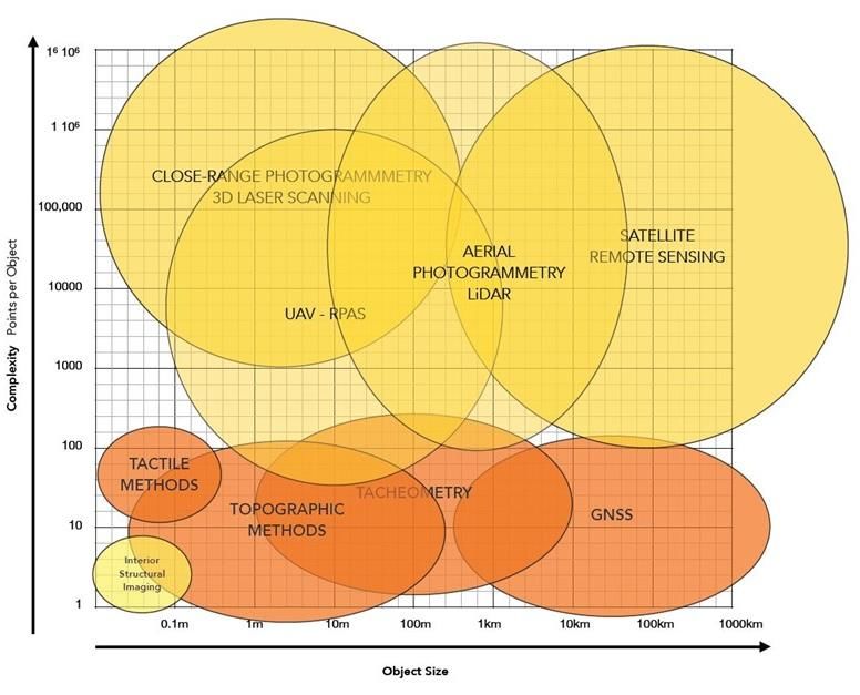
Study on quality in 3D digitisation of tangible cultural heritage:
mapping parameters, formats, standards, benchmarks, methodologies, and guidelines

few centimetres or even better, usually providing a solid network of Ground Control Points
(GCPs) [80, 81].

Surveying and photogrammetric methods are based on direct measurements of lengths and
angles, either on the monument or on images. They determine three-dimensional point
coordinates in a standard reference system and ensure uniform and specified accuracy
(25,26,78,79), also providing adaptability, flexibility, speed, security, and efficiency. Overall,
they have undisputed financial merits, in the sense that they are the only methods that
reliably meet any requirements with the least possible total cost and the most significant
total profit. To this measurement group belong laser scanners such as laser imaging,
detection, and ranging, both aerial9 (LiDAR) and terrestrial10 (TLS). They are able to
collect 3D points (a point cloud) in a minimal time frame [25, 26].

However, It should be stressed that since, to date, there is no generally accepted framework
for specifying the level of detail and the accuracy requirements for the various kinds of
geometric recording of monuments, every single monument is geometrically documented
based on the accuracy and cost specifications supplied or agreed to by the owner or
stakeholder [1-114].

At the time of writing this report (July 2021), there are many available methods for this
purpose, none of which can be considered obsolete. All can contribute something to the
final product [25, 26]. This means that disciplines involved in a tangible CH 3D data
acquisition project need to cooperate closely, exchange ideas, and formulate common
geometric documentation requirements as part of gaining a deep understanding of the
movable and/or immovable asset under consideration.

Boehler & Heinz [71] first attempted to illustrate the implementation range of the different
methods available, as shown in Figure 3. Today their diagram should be adapted to include
newly developed methodologies. In it, the implementation range of each technique in the
3D recording is illustrated in terms of both the number of points per object (y-axis) and object
size (x-axis). More traditional methods include hand and tactile measurements, which are
helpful for capturing essential details or small objects especially in museums. Geodetic and
tachymetric measurements - the ones obtained by using an electronic total station -
although accurate, can only record a limited number of points at long range.

9 LiDAR (accessed Jun. 14, 2021).
10 Terrestrial Laser Scanning (accessed Jun. 14, 2021).
 9
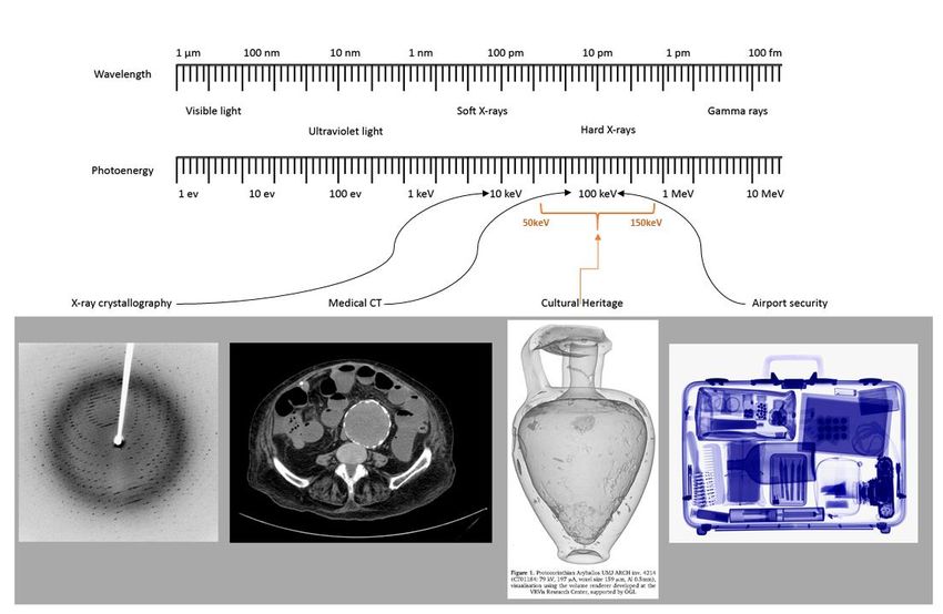
Study on quality in 3D digitisation of tangible cultural heritage:
mapping parameters, formats, standards, benchmarks, methodologies, and guidelines

Figure 3: Survey techniques defined by object complexity (points captured) and size. © Adapted from
 Boehler & Heinz (1999) [71]. © UNESCO Chair on Digital Cultural Heritage at CUT.

For the 3D geometric documentation of movable and immovable assets, the range of object
sizes could start from a few mm and go up to a couple of thousand metres, while the number
of acquired points and images should practically have no limit. Documentation methods
may be grouped in several ways. Firstly, according to those involving light recording (orange
areas in Figure 3) and those that do not (yellow areas).

However, the available data acquisition technologies can be classified depending on their
principle. Photogrammetry11, terrestrial or aerial, is an image-based methodology for
massive point acquisition at a considerable range. Laser scanning, terrestrial or airborne,
allows for enormous point acquisition.

In any case a form of radiating energy is always used for gathering geometrical and visual
information, therefore a first distinction can be made between penetrating and non-
penetrating radiation systems.

The penetrating category systems are based on similar X-Ray12 devices used and well
known in medical applications, mechanical (aeronautical) engineering, airport security and
detailed investigations by police and customs services (Figure 4). They allow the capture of
inaccessible internal structures and surfaces of small objects (see also 2.5).

11 Photogrammetry (accessed Jul. 28, 2021).
12 X-Ray (accessed Jun. 11, 2021).
 10
Study on quality in 3D digitisation of tangible cultural heritage:
mapping parameters, formats, standards, benchmarks, methodologies, and guidelines

Figure 4: X-Ray analysis in the area of Cultural Heritage

InfraRed13 thermography for non-destructive testing and evaluation aims at the detection of
sub-surface features (i.e. sub-surface defects, anomalies, etc.), owing to temperature
differences observed on the investigated surface during the digitisation by an infrared
camera. In temperatures of practical interest, all bodies emit electromagnetic radiation that
can be readily used for quantitative measurements. Infrared thermography or thermal
imaging is a measurement technique based on the detection of radiation in the infrared
spectrum (usually in the 2–5.6 μm and 8–14 μm regions). These two spectral bands are
commonly used, because of their low atmosphere absorption. The principal problem as far
as infrared measurements are concerned is the emissivity of the material(s). An infrared
camera detects and records the radiation emitted by a material under investigation and
renders this energy to a temperature – thermal image. In this process, the main
characteristic that describes the relation between the emitted radiation and the material’s
temperature, is termed as emissivity. Emissivity is actually a surface property that
characterises the ability of the investigated material to emit energy [65].

For non-penetrating 3D digitisation, the electromagnetic energy that is essentially used
covers the visible and the InfraRed13 spectrum. The latter may actually allow for a little
penetration under the illuminated surface depending on the actual wavelength used,
ranging from fractions of a millimetre for Near InfraRed, to several millimetres for the Far
InfraRed, used in so-called TeraHertz imaging14. That is also one of the main limitations of
the technique.

On the other hand, an advantage of thermography over destructive testing techniques is
that large areas can be scanned fast and without being destroyed during testing (Figure 5:
Overview of Infrared technologies for different investigations and Data Acquisition This
results in major savings in time, people, work and machinery. In addition, infrared
thermography has advantages over the other non-destructive techniques. The infrared

13 Infrared (accessed Jun. 10, 2021).
14 Terahertz non-destructive evaluation (accessed Jun. 10, 2021).
 11
Study on quality in 3D digitisation of tangible cultural heritage:
mapping parameters, formats, standards, benchmarks, methodologies, and guidelines

thermographic device is risk-free, as it does not emit any radiation and only records the
infrared radiation emitted from the material that is under assessment. Moreover, infrared
thermography is an area-investigating technique, whereas most of the other non-destructive
methods are either point- or line-testing methods. Furthermore, thermographic testing may
be performed during the hours of both day and night [65].

 Figure 5: Overview of Infrared technologies for different investigations and Data Acquisition
 in Cultural Heritage. © Adapted from chsopensource.org

Finally, environmental conditions (e.g. cloud cover, solar radiation, wind speed) also play
an important role in outdoor infrared thermographic surveys utilising passive recording
approaches, when working on monuments, sites and artefacts exhibited in open areas.

Within non-penetrating devices a further distinction should be made between active and
passive 3D data acquisition methods.

2.5. Active and Passive Recording Categories
In general, there are two types of recording methods, active and passive ones. Active
recording methods use directed radiant energy to mark a point in space, whereas passive
methods record the reflected radiation from a surface. Active sensors are typically terrestrial
laser scanners (TLS), structured light scanning (SLS) systems and range cameras. Passive
or image-based documentation systems include (cameras) aerial photogrammetry
(satellites, aircraft, and UAVs), terrestrial photogrammetry, and close-range
photogrammetry. These systems capture the surface geometry of an object as well as the
surface texture [67, 107].

A multi-view 3D reconstruction is another process for generating a 3D point cloud (and
model) from several overlapping images, using robust automated algorithms. The resulting
3D models are appropriate for metric information extraction for visualisation purposes, for
the creative industry and augmented or virtual reality applications. Passive methods include

 12
Study on quality in 3D digitisation of tangible cultural heritage:
mapping parameters, formats, standards, benchmarks, methodologies, and guidelines

studio image acquisition, uncontrolled environment image acquisition and video frames
extraction [25, 26, 80, 81].

2.5.1. Active Recording Systems
Active recording methods use their radiation to record points in space instead of sensing
the reflected radiation from another source. These sensors are commonly called range
sensors because they can measure the depth, or range of object points. Since they rely on
their radiation source, they are independent of scene illumination and can theoretically work
in totally dark environments. The most used active sensors in the 3D recording of CH are
as follows.

Total Station
The Total Station Theodolite15 (TST) is a beneficial geodetic survey instrument with near-
limitless measuring abilities. Recent advances in Total Station technology such as robotics
and GPS integration have increased the efficiency and accuracy of field surveys. A Total
Station allows the surveyor to choose individual points to measure, with each shot being
made with relatively high precision in angular and distance measurements. Although
accurate, this can be tedious and time-consuming if recording numerous individual shots of
more complex surface features.

Global Navigation Satellite Systems (GNSS)
3D coordinates of large-scale outdoor scenes can be calculated indirectly using Global
Navigation Satellite Systems (GNSS). Such measurements are accurate to the order of a
few centimetres or even better, usually providing a solid network of Ground Control Points16
(GCPs). The performance of GNSS is assessed using four criteria: (1) Accuracy: the
difference between a receiver’s measured and real position, speed or time; (2) Integrity: a
system’s capacity to provide a threshold of confidence and, in the event of an anomaly in
the positioning data, an alarm; (3) Continuity: a system’s ability to function without
interruption; (4) Availability: the percentage of time a signal fulfils the above accuracy,
integrity and continuity criteria.

Terrestrial Laser Scanning (TLS)
Laser scanners17 are active range sensors able to produce dense point clouds for an object,
recording information for the position (geometrical coordinates: X, Y, Z) of every point along
with the intensity of the reflected radiation. TLS is a ground-based version of the airborne
LIDAR frequently used for large archaeological sites, terrain and landscape mapping.
Terrestrial laser scanners are a relatively recent development for high-resolution mapping,
originally developed for as-built modeling of architectural and engineering structures. They
can also be used for high-resolution mapping of terrain, vegetation, and other landscape
features over limited distances in the range of 50–300 m. Like their airborne counterparts,
they are active sensors that emit laser signals to calculate distances based on the time
delay of the returned laser pulses [112]. TLS systems range from airborne laser scanning
for terrain surface modelling to mid-range terrestrial scanners for data acquisition of
facades, entire buildings, ensembles or sites, and to close-range 3D scanners for high-
resolution digitisation of movable objects such as archaeological finds, artefacts, and
sculptures. ALS (Airborne Laser Scanning) or LiDAR (Light Detection and Ranging),
mounted on aircraft or Unmanned Aerial Vehicles18 (UAVs), have become compact and
relatively lightweight [80, 81].

15 Total station (accessed Jun. 10, 2021).
16 Ground Control Points (accessed Jun. 10, 2021).
17 Laser scanning (accessed Jun. 11, 2021).
18 Unmanned Aerial Vehicle - UAV (accessed Jun. 11, 2021).

 13
Study on quality in 3D digitisation of tangible cultural heritage:
mapping parameters, formats, standards, benchmarks, methodologies, and guidelines

Laser scanners are commonly used in the field of CH digital documentation, as they enable
measuring natural or manufactured objects of different sizes, varying from parts of the
landscape, buildings and architectural elements down to smaller pieces up to a few
decimetres in size. The advantages of using this technology for 3D recording are the very
large number of points acquired in each scan in a short time, their high accuracy and
density. A large variety of TLS systems are commercially available: time-of-flight, phase-
shift, or triangulation scanners. These devices differ in their measurement principle,
maximum measuring range, speed (number of points acquired per second), the field of
view, resolution, accuracy, weight and cost, among other characteristics [2, 26, 80, 81].

3D laser technology is used for movable and immovable objects, including sensors with
time-of-flight, phase difference or triangulation using laser points, fringe, or other projection
patterns. Depending on the specific type of LiDAR hardware, laser scanners can record
small objects or large terrain areas. High-resolution hand scanning systems can record sub-
mm detail on the surface of an object, whereas terrestrial laser scanners are typically used
for the documentation of buildings. Unfortunately, at the time of writing this report, there is
no single TLS system capable of covering all sizes.

The Historic England guide to laser scanning for archaeological and architectural
applications [12, 67] highlights how the process related to the use of TLS technology can
be difficult due to occlusions and obstacles in scanning the object(s), which may limit
available data if incorrectly addressed. Laser scanners cannot see through solid objects
and this can cause problems in sites with excessive amounts of mobile objects blocking the
planned capture areas or in locations with elevations or with health and safety
considerations, such as evidence of asbestos or sulfur, unsafe buildings, adverse
environmental conditions and vegetation that prevent optimal display of the analysed
building or site.

The evaluation of the accuracy and precision of measuring equipment is critical in order to
achieve results that meet the specifications of a given project. Standard calibration models
and field procedures exist for all traditional surveying instruments, but are still lacking for
recently developed technologies like terrestrial laser scanners. The main reason is limited
knowledge of errors that affect these systems, owing to the proprietary design of the
scanners and their software, and the integration of many potential sources of error.

Mobile Laser Scanners (MLS)
Mobile Laser Scanners are also commercially available. Such systems include those
equipped with GNSS and Inertial Measurement Unit19 (IMU) sensors and – often - optical
cameras and can be mounted on moving vehicles (cars, floating or airborne platforms etc.)
or may even be carried by a person to perform range measurements in continuous or static
(stop-and-go) mode. Mobile laser scanning collects geospatial data from a mobile vehicle
fitted with LiDAR, cameras and other remote sensors. This mobility can be provided by cars,
trains, trucks, manned and unmanned aerial vehicles and boats. It is used in emergency
response situations to quickly assess the conditions on the ground, as well as for popular
mapping projects such as Google Maps20 and Street View.21 Manufacturers now also offer
scanners that can be submerged; these underwater scanners use laser beams of
advantageous wavelength for propagation in water, giving better results than sonar systems
used previously in underwater applications. At the moment of writing this report, their range
is short and accuracy relatively low, but MLS is an evolving and promising technology.

19 Inertial measurement unit (accessed Jun. 11, 2021).
20 Google Maps (accessed Jun. 11, 2021).
21 Google Street View (accessed Jun. 11, 2021).

 14
Study on quality in 3D digitisation of tangible cultural heritage:
mapping parameters, formats, standards, benchmarks, methodologies, and guidelines

Structured Light Scanning (SLS) Systems
Structured light scanning22 (SLS) systems project coded light patterns on the object surface,
recording the scene from one or more points of view and thus compute the depth based on
the deformation of the pattern on the object’s surface using the triangulation principle.
Coded patterns facilitate easy correspondence establishment between image points and
points on the pattern (pattern decoding), resulting in dense 3D point clouds of the scene. A
typical SLS system usually comprises low-cost off-the-shelf hardware, permitting ad-hoc,
easy to deploy, and custom-made solutions. One or two digital SLR cameras or machine
vision cameras mounted on a rigid base and supporting tripods and an LCD or DLP
projector are needed. The whole system is operated through current technology computer
software, which undertakes the system calibration, fully controls the data acquisition and
signal/data processing and the local or remote storage of data. The distance between the
scanner and the CH object, i.e., the base, may vary according to the size, location and
condition of the object of interest [54-84].

SLS systems are usually compact, lightweight and easy to implement. They provide high
accuracy and dense resolution results, making them a robust alternative to laser scanners
or even outperforming them. Among the advantages of the method is its capability to acquire
depth information for the entire field of view and not just one point per time, enabling fast
and efficient acquisition, as well as faster scan times. The method also produces dense and
accurate data, applies all the safety regulations in higher detail levels and is safe for people
to use, even to the naked eye.

Optical 3D Triangulation Scanners
Optical triangulation scanners23 usually consist of a projector and a camera, project a known
pattern onto the object, and measure the surface via triangulation methods and the
deviation of the pattern from the original. These systems are mostly used in the car and
aero industries and can provide sub-millimetre detail but give only a limited field of view and
short distances. They are also usually susceptible to the lighting conditions of the
environment.

Hybrid Systems
Hybrid systems are optical triangulation scanners and usually consist of a projector and a
camera. The system projects a known pattern onto the object and digitises the surface via
triangulation methods and the original pattern’s deviation. Hybrid systems can likewise
provide sub-millimetre detail but give only a limited field of view and at short distances and
are usually susceptible to environmental lighting conditions in a lab.

Depth or Range Cameras
The term is broad enough to include a variety of sensors with different working principles.
Depth or range cameras are sensing systems (also known as RGB-D cameras) capable of
retrieving the depth information of an object almost in real-time. They capture
simultaneously the colour and depth values of every pixel of the scene resulting in dense
point clouds. The depth value either comes directly from the sensor (ToF cameras) or is
calculated from stereo algorithms (passive or active stereo). Time-of-flight cameras acquire
3D information by using near-infrared (NIR) light cast on the object and measuring the time
delay between the emission and detection of the light. Passive stereo vision setups are
based on the triangulation principle, having a fixed base distance between the two cameras.

Depth cameras are more applicable in indoor scenes for objects at relatively close distances
due to their limitations. Several applications on CH objects can be found [25, 26, 80, 81],

22 What are the advantages of using a structured-light 3D scanner? (accessed Jun. 11, 2021).
23 3D scanning (accessed Jun. 11, 2021).
 15
Study on quality in 3D digitisation of tangible cultural heritage:
mapping parameters, formats, standards, benchmarks, methodologies, and guidelines

but problems such as accuracy constraints have restricted their usage to mainly
visualisation purposes rather than metric reconstructions.

During mapping applications, Simultaneous Localisation and Mapping (SLAM) algorithms24
are commonly in use for frame registration, i.e., camera pose estimation and sparse 3D
reconstruction. SLAM algorithms calculate the movement of the sensor with a simultaneous
reconstruction of the 3D points. The main idea is to use the environmental features
(landmarks) to calculate the position of the system in real-time using EKF (Extended
Kalman Filtering25). A typical SLAM pipeline consists of the following steps: landmark
extraction, data association, state estimation, state and landmark update.

2.5.2. Passive Recording Systems
Passive or image-based documentation methods record the light or radiation which
originates from an independent source (e.g., the sun or artificial lighting) and is reflected
from the object of interest. Image-based techniques process optical images to extract metric
information for the object. Especially for CH applications, image data acquisition is usually
preferred to other methods because it is efficient, non-intrusive, easily deployable both
indoors and outdoors and low-cost.

A big challenge is the development of new smart algorithms in photogrammetric techniques
that automate the traditional manual procedures enabling at the same time the usage of
any type of camera, thus achieving cost reduction. Computer vision26 has emerged as the
research field that addresses these problems towards automating the work chain and cost
minimisation [80, 81].

Compact consumer cameras and free or open-source software can be used to achieve
results comparable to traditional techniques or even to outperform them in precision, time
consumption and cost. Aerial photogrammetry (using satellites, aircraft, and UAVs as
platforms) and close range (terrestrial) photogrammetry are commonly applied to document
CH objects since these methods sufficiently capture the geometry along with the texture of
an object. The image-based techniques can be divided into single, stereo, or multiple views,
according to the number of images they use to retrieve the metric information for the 3D
space.

A multi-view 3D reconstruction generates a 3D point cloud (and model) from several
overlapping images using robust automated algorithms. At the time of writing this report this
is a rich research area of increased interest in computer vision and photogrammetry and a
widely used technique due to its time- and cost-effectiveness and the accuracy of its results.
The existing Structure from Motion, Multi-View Stereo or dense stereo matching algorithms
are robust enough to reconstruct any set of overlapping images in 3D space, if they depict
the object scene from various viewing angles, even with unordered sets of random photos
taken by different sensors (such as the ones found in Internet repositories27). The pre-
condition is that the images are overlapping (for high quality results an overlapping factor
over 85% is required). The resulting 3D models may be used for metric information
extraction, architecture, preservation, visualisation purposes and many other applications,
such as augmented or virtual reality. Furthermore, accurate 2D products such as
orthoimages and vector plans can be generated.

Suitable 3D documentation methods [80, 81] should be determined once the stakeholder
and project requirements are defined - in particular the level of detail that needs to be
captured. While it is always desirable to capture the best possible detail and resolution, this

24 Simultaneous Localisation and Mapping (SLAM) algorithms (accessed June 12, 2021)
25 Extended Kalman Filtering (accessed Jun. 12, 2021).
26 Computer vision and 3D reconstruction (accessed Jun. 11, 2021).
27 Four Dimensional Cultural Heritage World (accessed Jun. 11, 2021).

 16
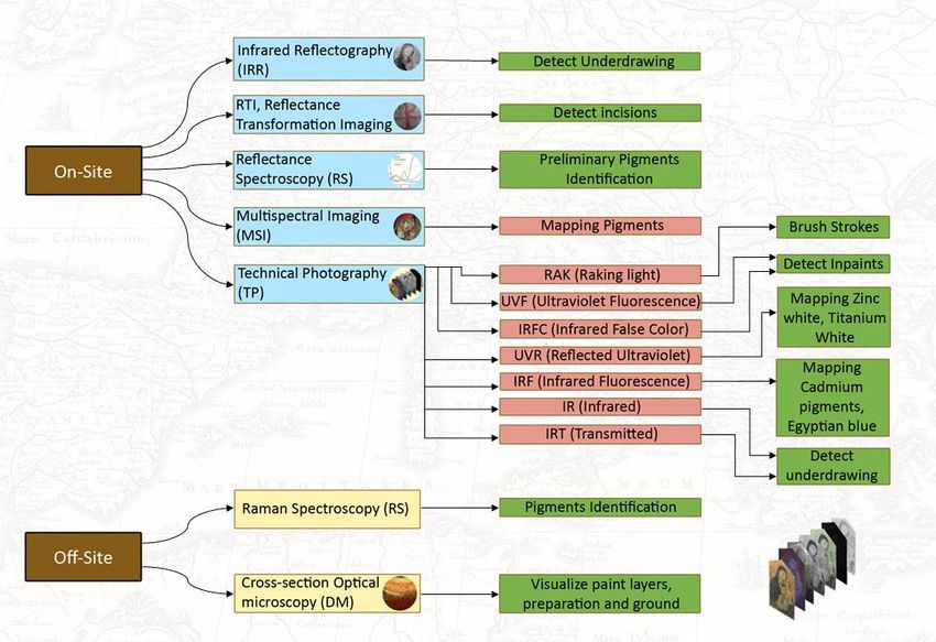
Study on quality in 3D digitisation of tangible cultural heritage:
mapping parameters, formats, standards, benchmarks, methodologies, and guidelines

is a matter of the technologies to be used, the duration of the documentation, the data size,
and cost. For each object, the parties involved need to agree on the required level of detail
to be achieved. For example, with a sculpture, it might be interesting to look at chisel traces,
while when documenting the smooth walls of a building, this level of detail might not be of
such relevance [81]. Therefore. data size increases with the level of detail. Larger numbers
of close-up photographic images of a wall will provide more meaningful information. Still
more data is generated than with a single image, requiring more processing and data
storage capacities.

It is, therefore, necessary to establish a level of detail at the outset of any documentation
project. The level may be consistent for the entire project or relative to specific features of
the project. The selection of technology or technologies, duration of the documentation,
data size, data processing, and cost will impact the project’s level of detail, resolution, and
accuracy. With time and budget allowing, it may be desirable to capture the highest possible
detail, resolution, and precision, influencing these selections. Each SfM technology has
individual strengths and weaknesses. It is essential to be aware of the technical background
to decide on the most suitable technology for a project.

Aerial Photogrammetry
Aerial photogrammetry28 includes imagery systems situated within satellites, aircraft, and
UAVs. At the time of wroiting this report, it constitutes a vivid research area in computer
vision and photogrammetry and is a widely used technique due to its time and cost-
effectiveness along with its accurate results. The image-based methods can be divided into
single, stereo, or multiple views according to the number of images they use to retrieve the
metric information for the 3D space. A multi-view 3D reconstruction generates a 3D point
cloud (and model) from several overlapping images, using robust automated algorithms
[100, 101].

Photogrammetry
Photogrammetry can be used also for the digitisation of small CH objects, achieving sub-
millimetre accuracy and resolution. A wide variety of digital cameras are available for use,
equipped with sensors of various functionality and ever-improving resolution capability. The
hardware may require custom adaptation for CH objects – involving other imaging principles
like panoramic cameras, fisheye systems, catadioptric imaging systems and rotating
cameras [80, 81, 96, 99, 100, 101].

2.6. Multi-Sensory and Multi-Spectral Scanning Technologies
The digitisation of CH tangible objects (especially small objects in museums, paintings in
art galleries or frescoes and mosaics in monuments and sites) for conservation and analysis
consists of a wide palette of methods and techniques offering complementary information.
The use of spectroscopic digitisation is important for the determination of material
properties, while ultrasonic microscopy is used to obtain structural information of an art
object. Combining these methods with imaging produces an information-rich map, where
every pixel contains various spectra, image and stratigraphy information.

The techniques to study materials used in CH artefacts and frescoes are significant in
understanding and preserving these CH assets. Curators, restorers and conservators
routinely use those approaches and exploit information on materials to gain insights about
the way an artwork has been made, when it was made, the techniques used, the
environmental conditions of preservation, previous conservation interventions and to gather
indications for planning future interventions. Materials in CH are studied from many different
viewpoints, ranging from the acquisition of basic information, such as surface average

28 Aerial survey (accessed Jun. 11, 2021).
 17
You can also read