SITUATION ANALYSIS AND NEEDS ASSESSMENT REPORT - ROHAL SOUNG VILLAGE Battambang Province, Cambodia
←
→
Page content transcription
If your browser does not render page correctly, please read the page content below
SITUATION ANALYSIS AND NEEDS ASSESSMENT REPORT   1

             SITUATION ANALYSIS
        AND NEEDS ASSESSMENT REPORT

       ROHAL SOUNG VILLAGE                A Selected Climate Smart
Battambang Province, Cambodia             Village Site

                              February 2015

           Thuon Try, Eam Dyna, Alice Joan G. Ferrer, Bui Tan Yen,
                 Yumiko Kura, and Leocadio S. Sebastian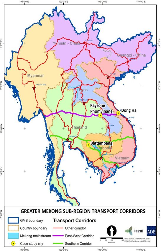
2         ROHAL SOUNG VILLAGE, BATTAMBANG PROVINCE, CAMBODIA

    Suggested citation

    Try T, Dyna E, Ferrer AJ, Yen BT, Kura Y, and Sebastian LS. 2015. Situation Analysis and Needs Assessment
    Report for Rohal Soung Village and Battambang Province, Cambodia. CGIAR Research Program on Climate
    Change, Agriculture and Food Security (CCAFS), Copenhagen, Denmark.

    Titles in this series aim to disseminate interim climate change, agriculture and food security research and
    practices and stimulate feedback from the scientific community.

    Published by the CGIAR Research Program on Climate Change, Agriculture and Food Security (CCAFS).

    CCAFS Coordinating Unit - Department of Agriculture and Ecology, Faculty of Life Sciences, University of
    Copenhagen, Rolighedsvej 21, DK-1958 Frederiksberg C, Denmark. Tel: +45 35331046; Email: ccafs@life.
    ku.dk

    Creative Commons License

    This paper is licensed under a Creative Commons Attribution – Noncommercial–NoDerivs 3.0 Unported
    License.

    Articles appearing in this publication may be freely quoted and reproduced provided the source is
    acknowledged. No use of this publication may be made for resale or other commercial purposes.

    © 2014 CGIAR Research Program on Climate Change, Agriculture and Food Security (CCAFS)

    Disclaimer

    This report has been prepared as an output for the baseline activities under the CCAFS program and has
    not been peer reviewed. Any opinions stated herein are those of the author(s) and do not necessarily reflect
    the policies or opinions of CCAFS, donor agencies, or partners.

    All images remain the sole property of their source and may not be used for any purpose without written
    permission of the source.
SITUATION ANALYSIS AND NEEDS ASSESSMENT REPORT        3

Summary
Rohal Suong village is located in Battambang province, Cambodia. The Situation and Needs Assessment
was conducted in the village as part of the major initial work to collect data that will serve as baseline
information to inform planning of CCAFS intervention and to form the basis for monitoring change over
time. The baseline work was conducted in November to December 2014. Rohal Suong is a typical farming
village that is moderately diversified, with two rice cropping, some vegetables and fruits, with some surplus
to sell in an average year. Rice fields are connected to the Sangke River as a source of water throughout the
year and to Tonle Sap Lake and associated flooded forests as a source of fish, firewood, and other animals
and plant products. Small-holder agriculture production system prevalent in the village appears to be not
very profitable because of the high cost of inputs and limited market and value chain development. Farming
families have taken several strategies to increase their overall income by expanding the farming area,
intensifying rice production, and seasonal labor migration. These strategies have negative implications:
loss of forest and grassland to farmland, degradation of water quality and soil, and labor shortage in the
village for agriculture. Raising small livestock is widely practiced as an income generation option, while
large livestock is becoming less popular due to the shortage of grazing land. The general perception among
the villagers is that the condition of natural resources is declining. Flooded forests are declining because of
deforestation and agriculture encroachment. Fisheries resources are declining because of overexploitation
and loss of habitats. Meanwhile, the village is also vulnerable to extreme events such flash flood, drought,
crop disease and insect outbreak. The village has been supported by a variety of external agents through
agricultural development, natural resource management, and food security programs, including some
large donor programs, and received in-kind support as well as direct agriculture input subsidies. Several
community institutions exist and are functioning well. The local production systems are well adapted to
the natural seasonal fluctuation in rainfall and flooding regime, but occasional extreme flooding events
cause crop damage and food shortage situation. The existing interventions are not directly associated with
specific climate-related issues. There is an opportunity for CCAFS to identify and enhance existing practices
that can become good examples of “climate smart agriculture”, and be promoted more widely as such, to
increase the general awareness of the importance of climate smart agriculture practices.

Keywords
Rohal Suong, situation analysis, needs assessment, CCAFS
4         ROHAL SOUNG VILLAGE, BATTAMBANG PROVINCE, CAMBODIA

    About the Authors
    •   Mr. Thuon Try is a professional researcher with over a decade experience in Cambodia and
        neighboring countries. He is engaged with CCAFS as a short term consultant. Since 2002,
        his research interest includes natural resource governance (land, forest, water, and fishery),
        rural livelihood systems, climate change adaptation and mitigation, REDD, CDM, hydropower
        development, urbanization, climate change impact and vulnerability assessment. He is
        currently affiliated with the Faculty of Development Studies, Department of Natural Resource
        Management and Development of Royal University of Phnom Penh.
    •   Mr. Eam Dyna is a researcher at WorldFish. He has six years experience in research on
        fisheries resource management, participatory action research, climate change adaptation,
        participatory video, and community development. He is currently involved with the CRP
        research program on Climate Change, Agriculture and Food Security and other WorldFish’s
        research projects.
    •   Yumiko Kura, PhD. She is an environment and natural resource management specialist with
        experiences in the field of fisheries policy, aquatic resource management, and environmental
        conservation, in several countries in Asia and Africa. Dr. Yumiko is currently the Regional
        Program Manager of WorldFish in the Greater Mekong Region.
    •   Alice Joan G. Ferrer, PhD. She is a faculty member in the Division of Social Sciences,
        University of the Philippines Visayas, Miagao, Iloilo, Philippines. Her research background is in
        policy analysis, gender, health policy and economics, and fishery social science.
    •   Bui Tan Yen, PhD. He is the Science Officer of CCAFS program in Southeast Asia, based in
        Hanoi, Vietnam. He has 20 years experience in Agronomy, Geographic Information System,
        and land use planning.
    •   Leocadio S. Sebastian, PhD. He is the current regional program leader for CCAFS Southeast
        Asiawhere he leads the integration of CCAFS agenda into the regional agenda and national
        program in CCAFS focus countries.
SITUATION ANALYSIS AND NEEDS ASSESSMENT REPORT   5

Table of Contents
1. INTRODUCTION		                                                                    9
2. METHODOLOGY		                                                                     10
3. SITUATION ANALYSIS		                                                              11
   3.1 Geographical location 		                                                      11
   3.2 Demographics		                                                                12
   3.3 Local climactic information		                                                 14
   3.4 Natural Resource Utilization		                                                16
		      3.4.1 Agriculture and forestry land use		                                    17
		      3.4.2 Protected areas		                                                      18
		      3.4.3 Water resources		                                                      20
   3.5 Infrastructure		                                                              22
		      3.5.1 The PPCR (Pilot Program for Climate Resilience)		                      23
		      3.5.2 Railway rehabilitation project		                                       23
		      3.5.3 Roads & bridges under strategic plan		                                 24
		      3.5.4 Irrigation and hydropower 		                                           25
		      3.5.5 Battambang - flood control		                                           25
		      3.5.6 Local economic and market town development		                           26
   3.6 Production and Livelihood systems		                                           26
		      3.6.1 Crops 		                                                               26
		      3.6.2 Livestock		                                                            28
		      3.6.3 Fishery		                                                              28
		      3.6.4 Off-farm employments		                                                 29
   3.7 Food Security Status and Trends		                                             36
		      3.7.1 Nutrition of children		                                                36
		      3.7.2 Nutritional status of women		                                          37
   3.8 Hazards and Vulnerability 		                                                  37
		      3.8.1 Floods 		                                                              39
		      3.8.2 Impacts of Flooding		                                                  41
		      3.8.3 Vulnerability sectors		                                                43
		      3.8.4 Rohal Soung 		                                                         45
   3.9 Mitigation Measures		                                                         46
   3.10 Climate Change Perception		                                                  46
6         ROHAL SOUNG VILLAGE, BATTAMBANG PROVINCE, CAMBODIA

       3.11 Organizational Landscape		                                                           51
    		      3.11.1 Organizations related to food security		                                      53
    		      3.11.2 Organizations related to natural resource management 		                       55
       3.12 Information Network		                                                                55
    		      3.12.1 Telecommunication Services		                                                  56
       3.13 Social and Gender Differentiation		                                                  58
       3.14 Health/Nutrition Profiles and other Livelihood Outcomes		                            60
    4. NEEDS ASSESSMENT		                                                                        61
       4.1 Strengths and weakness		                                                              61
       4.2 Priority issues		                                                                     64
    5. RECOMMENDATIONS 		                                                                        65
    REFERENCES			                                                                                65
    Annex				                                                                                    68

    List of Tables
    Table 1.    Population trends in Battambang, 2007-2010                                       12
    Table 2.    Projected rainfall and temperature changes by 2050, Battambang                   16
    Table 3.    Area (ha) of major land categories by district in Battambang province            16
    Table 4.    Area (ha) of annual crops                                                        17
    Table 5.    Protected Areas in Battambang                                                    18
    Table 6.    Potential irrigation and hydropower development and investment                   25
    Table 7.    Yield and production of annual crops in Battambang province                      27
    Table 8.    On-farm and off-farm employment in Battambang province in recent years           27
    Table 9.    Animal and livestock production values from 2012, 2013, and 2014                 28
    Table 10.   Manufacturing and services in Battambang                                         29
    Table 11.   Summary key processing sites and enterprises in Battambang province, 2012-2014   30
    Table 12.   Key results from economic census in Battambang 2011                              32
    Table 13.   Crop Calendar                                                                    33
    Table 14.   Summary of main occupation activities of households                              34
    Table 15.   Child nutrition status in Battambang 2010                                        36
    Table 16.   Percentage of River Basin catchments and elevation in Battambang                 39
    Table 17.   Flood records and flood frequency analysis                                       39
    Table 18.   Extent of flooding by Sangkat in Battambang town                                 40
    Table 19.   Social sector affected by the district in Battambang province                    41
    Table 20.   Extreme events which occurred in the village                                     43
    Table 21.   Observed manifestations of climate change                                        50
    Table 22.   List of organizations identified by local community groups                       51
SITUATION ANALYSIS AND NEEDS ASSESSMENT REPORT   7

Table 23.    List of key organizations that play an important role in Rohal Suong                   52
Table 24.    Summary main activities of organizations that working on food security                 54
Table 25.    Summary main activities of organizations that working on natural resources             55
Table 26.    Radio stations and their frequency in Battambang province                              56
Table 27.    Information network existing in Rohal Suong village                                    57
Table 28.    Migration status in Battambang (female out of total)                                   58
Table 29.    Job migrations in Battambang                                                           58
Table 30.    Number of people working outside their home in 2008                                    59
Table 31.    Domestic migration for six provinces around Tonle Sap Lake                             59
Table 32.    Women health situation                                                                 60
Table 33.    Number of families using toilet, 2012-2014                                             61
Table 34.    Constraints in Socioeconomic development in Battambang River Basin                     62

List of Figures
Figure 1.    Location of Battambang in Greater Mekong Sub-region                                    11
Figure 2.    Location of the Rohal Suong village in Aek Phnom district, Battambang Province         12
Figure 3.    Total population by district of the province by 2009                                   13
Figure 4.    Population projection based on baseline 2010                                           13
Figure 5     Distribution of annual rainfall in Cambodia (1991-2007)                                14
Figure 6.    Rainfall trends in Battambang from 2001 to 2010                                        15
Figure 7.    Baseline average annual maximum temperature at country level                           15
Figure 7.    Villagers in Rohal Soung are building an irrigation canal                              21
Figure 8.    Four main sectors of employment in Battambang by district in 2010                      27
Figure 9.    Direct seeding in Rohal Suong village                                                  32
Figure 10.   Trends of nutritional status among women aged 15-49 at national level                  37
Figure 11.   Provinces vulnerable to flood and drought (MOE et al., 2013)                           38
Figure 12.   Total monthly rainfall in 2013, Battambang                                             40
Figure 13.   Monthly water level Sangkae River in 2013 (PDOWRAM, 2013)                              41
Figure 14.   Impact on agriculture of 2013 flood                                                    42
Figure 15.   Impact on roads and infrastructure of 2013 flood                                       42
Figure 16.   Experience of climate change                                                           47
Figure 17.   Observation of climate change                                                          48
Figure 18.   Causes of weather pattern change in Cambodia                                           48
Figure 19.   Understanding the present and future impact of climate change to Cambodia              49
Figure 20.   Discussing organizational landscape with villagers in Rohal Suong village              51
Figure 21.   Identifying organizations related to food security with villagers                      53
Figure 22.   Percentage of women delivering a baby by a trained midwife in each district
             in the province                                                                        61
8 ROHAL SOUNG VILLAGE, BATTAMBANG PROVINCE, CAMBODIA
Abbreviations
ADB Asian Development Bank
AUSAID Australian Government Aid Program
CDIA Cities Development Initiative in Asia
CNMC Cambodia National Mekong Committee
CSA Climate-Smart Agriculture
CSV Climate Smart Village
CVI Climate Vulnerability Index
FAO Food and Agriculture Organization
GMS Greater Mekong Sub-region
ICEM International Center for Environmental Management
JICA Japan International Cooperation
KAP Knowledge, Attitude, and Practice
MAFF Ministry of Agriculture, Forestry and Fisheries
MLMUC Ministry of Land Management, Urban Planning and Construction
MOE Ministry of Environment
MOWRAM Ministry of Water Resource and Meteorology
MRC Mekong River Commission
NAPA National Adaptation Program of Action to Climate Change
NCDD National Committee for Democratic Development and Decentralization
PPCR Pilot Program for Climate Resilience
RGC Royal Government of Cambodia
SPCR Strategic Program for Climate Resilience
UNDP United Nations Development Program
WB World Bank
WFP World Food Program
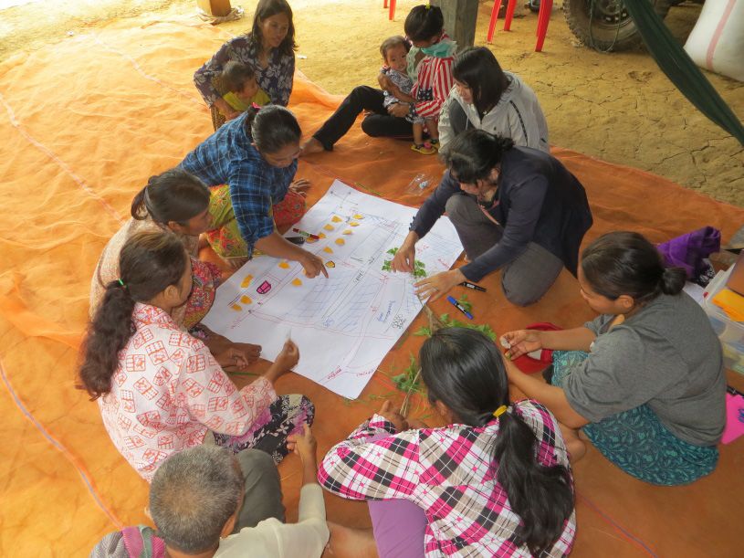
KHR Cambodia currencySITUATION ANALYSIS AND NEEDS ASSESSMENT REPORT 9 1. INTRODUCTION The Consultative Group on International Agricultural Research (CGIAR) Research Program on Climate Change, Agriculture and Food Security (CCAFS) is a strategic 10-year partnership between the CGIAR and Future Earth to deal with threats posed by a changing climate for achieving food security, enhancing livelihoods, and improving environmental management. Started in 2010, CGIAR-CCAF’s major initial work include collecting baseline information through studies at the household and village levels, and the organization baseline study in selected sites in the three regions of East Africa, West Africa and South Asia.1 The main aim is to collect data that serve as baseline information at each site to inform planning of CCAFS intervention and to form the basis for monitoring change over time (after 5 years and 10 years from the baseline period) in the selected sites. In the Southeast Asian region, the six selected sites with potential to become climate smart villages (CSVs) are: (1) Rohal Soung village, Battambang province, Cambodia; (2) Ekxang village, Vientiane province, Lao PDR; (3) Pailom village, Savannaket province, Lao PDR; (4) Ma village, Yen Bai province, Vietnam; (5) My Loi village, Ha Tinh province, Vietnam; and (6) Tra Hat (VN03), Bac Lieu province, Vietnam. Complementing the baseline data collection activities is the Situation Analysis and Needs Assessment (SANA). The baseline data collection in these sites was conducted in 2014. The aim is to have a deeper understanding of the selected sites to enable the design of appropriate and feasible intervention that will support their transformation to climate-smart villages in time. Specifically, the objectives of the SANA are: 1) To understand the current situation of the selected site, and 2) To identify the priority needs of the selected site in support of developing its agriculture and livelihoods while mitigating and adapting well to climate change. This report presents the results of the SANA for Rohal Soung village, Battambang Province, Cambodia. Data collection activities at the Rohal Suong village were led by the WorldFish Centre, one of the CGIAR research centers. This report has five parts. Following this introduction is the section on Methodology that describes the data and the sources of data used in the report, highlighting the relations of data collection activities for this report to other baseline data collection activities in the area. The third and the fourth sections present the results of the Situation Analysis and the Needs Assessment, respectively. A Recommendation section ends this report. 1 More information about CCAFS sites is available at http://ccafs.cgiar.org/where-we-work
10     ROHAL SOUNG VILLAGE, BATTAMBANG PROVINCE, CAMBODIA

 2. METHODOLOGY
 To facilitate SANA, additional primary and secondary data were collected. Needed data were also partly
 drawn from the village baseline study (VBS) and from the organizational baseline study (OBS). Primary and
 secondary data at the province, district, commune and village levels were collected. The sources of primary
 data were key informant interviews (KIIs) and the three gender-differentiated focus group discussions
 (FGDs). Secondary data consisted of official documents and research reports collected from various offices
 in the province and those that were available on official websites.

 Prior to the CSV activities, the WorldFish Centre conducted several projects in Rohal Soung village. Focus
 group discussions and a household survey were carried out in 2014-2015 in Rohal Soung village among
 seven other villages in the district. The results of these previous research projects were useful and were
 updated and used for the SANA. At the provincial and district levels, key informant interviews were
 conducted when secondary data was unavailable.

 A list of topics for the SANA was drawn by a group of social scientist at a meeting during the planning
 workshop for the implementation of the CSV in July 2014. The list includes 15 topics with data needed at
 the provincial/district and village levels: Natural resource utilization, Organizational landscape, Information
 network, Mitigation measures, Production and livelihood systems (including markets), Current and past
 natural resource management initiatives, Food security status and trends, Demographics, Climate change
 perception, Institutional landscape and governance, Social and gender differentiation, Hazards and
 vulnerability, Local climatic information, Health and nutrition profile and other livelihood outcomes, and
 Stakeholders. Four topics were common with the VBS: natural resource utilization, organizational landscape,
 information network, and mitigation measures.

 CCAFS has identified lead CG partners as well as local partners in every site in the implementation of its
 activities. For Rohal Soung, the WorldFish Center is the lead CG partner. For the baseline surveys, the teams
 in the six CCAFS sites were trained in September 2014 (for VBS, OBS, and SANA) and in November 2014 (for
 Household Baseline Study). Guide materials were given to the teams for reference.

 With VBS and SANA as complementary activities, field data collection was conducted at the same time.
 The FGDs were conducted for VBS in Rohal Soung village from 28th to 30th October 2014 with participation
 of 90 villagers. The FGDs were organized for men and women separately. Topics relevant to SANA that
 were collected during the FGDs include on natural resource utilization, organizational landscape, and
 information network. Additional information was collected from November to December 2014. A feedback
 seminar was held in the village with 15 villagers who had not participated in the FGDs as well as leaders
 from the province down to the village levels.

 Data on institutional landscape was collected through a participatory group exercise where important
 organizations were listed and their involvement in the community identified. From the list, the five most
 important organizations were selected by villagers for interviews using the protocol set under the OBS.
 Detailed information is given in the site analysis report of Rohal Suong.
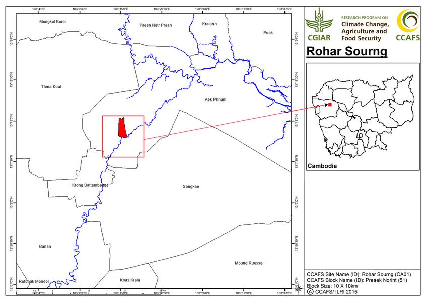
SITUATION ANALYSIS AND NEEDS ASSESSMENT REPORT    11

3. SITUATION ANALYSIS
3.1 GEOGRAPHICAL LOCATION

Battambang province is situated in the northwest part of Cambodia (Figure 1), about 300 km from Phnom
Penh via national road No 5. The province borders on Beanteay Meanchey, Siem Reap, and Pursat provinces.
The western boundary is framed by the enclave of Pailin province and the national border with Thailand. At
its eastern tip, the province is connected to the Tonle Sap Lake. The province covers an area of about 11,803
km2, comprising 13 districts, one municipality, 96 communes, and 741 villages.

In recent years, Battambang has reactivated its strategic location as an economic and trading center.
Climate change and the degraded natural environment pose as a threat.

Rohal Suong, one of CSVs in the Southeast Asia, is located in the Prek Norin commune, Eak Phnom district
of Battambang province (Figure 2). It is About 15 km from Battamabang town. Rohal Soung village is a
land-based village (Johnstone et al., 2013) situated along the Sangke River. The total land size of Rohal
Soung village is 291 ha, comprised mainly by paddy field, crop plantation field (Chamkar), and residential
areas (Praek Norint Commune, 2012).

Figure 1. Location of Battambang in Greater Mekong Sub-region (GMS) ( ICEM, 2014)
12        ROHAL SOUNG VILLAGE, BATTAMBANG PROVINCE, CAMBODIA

 Figure 2. Location of the Rohal Suong village in Aek Phnom district, Battambang Province

 3.2 DEMOGRAPHICS

 In 2005, the total population of the province was 952,306 (185,868 families) and it increased to 1,043,928
 (205,351 families) in 2008 (NCDD, 2009). Table 3 shows the population trend for years 2007 to 2010. During
 these years, the total population and a number of families were increasing, but the rate of increase was
 declining. Meanwhile, the number of female-headed households was increasing. Compared to other
 districts, Battambang has the highest population (151,656) in 2008 (Figure 3).

 Table 1. Population trends in Battambang, 2007-2010

                                    2007                  2008              2009                2010
     Total population              998,896              1,043,928         1,048,214           1,071,209
     % Increase/Decrease                                  4.5 %             0.4 %               2.2 %
     Total number of               196,721               205,351           212,294             218,843
     families

     % Increase/Decrease                                  4.4 %            3.38 %                3.1 %
     Number of female           29,492 persons       29,664 persons    30,410 persons       31,986 persons
     headed households
 Source: (NCDD, 2010)
SITUATION ANALYSIS AND NEEDS ASSESSMENT REPORT 13 Figure 3. Total population by district of the province by 2009 (NCDD, 2009). Over the next 10 years, the population of Battambang is projected to increase. Figure 4 shows the range of population projections based on three growth rate scenarios. Source: author’s calculation based on NCDD data book 2010 Figure 4. Population projection based on baseline 2010 Meanwhile, Rohal Soung village had a total population of 1,354 (342 families), comprised of 670 women and 684 men in 2014. About 36% of total families were identified as the poorest in the village (Praek Norint Commune, 2012).
14     ROHAL SOUNG VILLAGE, BATTAMBANG PROVINCE, CAMBODIA

 3.3 LOCAL CLIMACTIC INFORMATION

 During the southwest monsoon season from May to November, about 90% of the annual rainfall occurs.
 The remaining months are hot and less humid, leading to particularly high potential evapotranspiration in
 March and April. The average annual rainfall amount is extremely variable between different parts of the
 country.

 Figure 5 Distribution of annual rainfall in Cambodia (1991-2007) (ADB, 2013)

 Figure 5 below shows the annual rainfall distribution in Cambodia. The observed maximum 24-hour rainfall
 is about 200 mm throughout the region.

 In the northwest part of Cambodia and around the Great Lake, the rainfall is generally bimodal, with a first
 peak occurring between May and June, followed by a period of lower rainfall between June and August
 while the monsoon rains return during August through October. At this time, the rainfall is usually heavier
 and can cause widespread flooding. Yet this bimodal pattern is erratic and widely unpredictable, causing
 difficulties in farmers’ crop planning.

 Figure 6 below shows yearly rainfall trends in Battambang in 2001 to2010. The figure shows somewhat a
 cycle of increasing and decreasing amount of rainfall. The amount of rainfall declined from 2002 to 2004,
 increased in 2005 to 2008, and declined again until 2010. The highest number of rainy days was recorded
 in 2001 (141 raining days). In the following years, the annual number of days ranged between 106 and 131
 days.
SITUATION ANALYSIS AND NEEDS ASSESSMENT REPORT   15

                            Rainfall trends Battambang, 2001-2010

               1600
               1400
               1200
               1000
                800
                600
                400
                200
                  0
                         2001   2002   2003   2004   2005   2006   2007   2008   2009   2010
        # raining days   141    106    112    110    124    118    131    124    127    131
        Rainfall (mms) 1141 1387.4 1058.3 993.8 1237.1 1219.4 1321.8 1479.8 1391.3 1332

Figure 6. Rainfall trends in Battambang from 2001 to 2010

Temperature
Figure 7 shows baseline average annual maximum temperature (°C) 1961-1990 at the country level.

Figure 7. Baseline average annual maximum temperature at country level (MOWRAM/ADB, 2013)

Overall projection of climate change in Battambang
According to an ICEM (2014) case study on building urban resilience in cities in the Greater Mekong
Subregion (GMS), climate change is projected to significantly impact Battambang. A combination of
current land use change as well as change in hydrological flows from upstream down through the town
and Tonle Sap Lake are expected. Table 2 below shows that average rainfall and maximum temperature are
expected to increase by 2050.
16 ROHAL SOUNG VILLAGE, BATTAMBANG PROVINCE, CAMBODIA
Table 2. Projected rainfall and temperature changes by 2050, Battambang (ICEM, 2015)
Projected changes to average rainfall & maximum Baseline With C.C. Change
temperatures by 2050
Average annual rainfall 1300 mm 1365 mm +5 %
Total rainfall in wet season 1170 mm 1267 mm +8.3 %
Total rainfall in dry season (Mar - Aug) 230 mm 224 mm -2.5 %
Average daily maximum temperature (annual) 32 °C 34.2 °C +2.2 °C
Average maximum temperature in wet season 31 °C 33.6 °C +2.6 °C
Average maximum temperature in dry season 32.5 °C 34.4 °C +1.9 °C
By 2050, Battambang’s total rainfall during the wet season would increase by about 8.3%. Battambang’s
average daily maximum temperature during the dry season would increase by between 1.8 -1.9°C. In
summary, the expected climate changes by 2050 in Battambang are significantly hotter and wetter in the
wet season and hotter and drier in the dry season
3.4 NATURAL RESOURCE UTILIZATION
Battambang is part of the greater natural landscape of the Cardamom region2. The natural habitats of this
region form a complex network of interconnected landscapes and watersheds that provide important
ecosystem services to the region (Killeen 2012). Table 3 shows the distribution of land use categories in the
districts of Battambang province. More than half of the land area in Battambang province is agricultural
land (596,497 ha). About 25% is forest land. Half of the forest land is flooded.
Table 3. Area (ha) of major land categories by district in Battambang province
District Total area Forest land Agricultural Construction Others
Total Flooded land land
Forest land
Banan 79,600 33,443 - 32,171 12,843 1,143
Thmar Koul 81,700 15,400 15,400 60,100 3,540 1,660
Battambang 11,544 - - 8,558 2,870 117
Bavel 92,300 17,471 601 49,293 4,541 20,995
Ek Phnom 63,500 46,940 46,940 13,700 2,860 -
Moung Russei 124,995 28,319 28,319 73,965 6,696 16,015
Rotanak Mondul 79,200 25,520 - 46,400 3,780 3,500
Sangkae 83,00 35,200 35,200 40,017 7,763 20
Sam Lout 180,300 80,181 - 55,20 6,410 38,509
Sampov Luon 51,900 9,100 - 36,396 450 5,954
Phnom Proek 70,400 8,276 - 32,397 2,602 27,125
Kam Rieng 56,600 5,821 - 47,009 2,100 1,670
Koas Kralor 105,000 30,000 - 60,000 15,000 -
Rukh Kiri 57,688 10,805 - 41,291 5,592 -
Total 1,137,727 246,476 126,460 596,497 78,047 116,708
Source: NCDD Battambang Province data book 2009.
2 This region covers approximately one third of the countrys’s land surface and spans 24 of its provinces, including Koh
Kong, Pursat, Battambang, Pailin, Sihanouk, Kampong Speu, Kampong Chhnang, Kam Pot and Kep.SITUATION ANALYSIS AND NEEDS ASSESSMENT REPORT 17
3.4.1 Agriculture and forestry land use
The five main categories of agricultural and forestry land in Battambang province are as follows (JICA et al.,
2007):
1. Paddy Field: Most paddy fields in the basin are rainfed. The irrigated paddy field is estimated at about
22,000 ha or 24% of the total paddy field area. The prevailing rice cultivation method is direct sowing
and the prevailing cropping pattern is a single cropping of rice in the wet season. The area under
receding or floating rice cultivation is limited to 270 hectares in the basin.
2. Field Crop Land: Field crop land makes up only 7,020 ha or 1.2 % of the basin and is almost exclusively
found along small valleys in the mountain areas. The major crops cultivated in the wet season include
corn, beans, and cassava. Fertile Cambisol field crop land in the basin of Pailin province was developed
for commercial scale for upland crop cultivation.
3. Garden Crop Land: Garden crop land accounts for 15,990 ha or 3 % of the basin. It is divided into
garden crop fields and village garden crop fields. These are mostly found along the Sangkae River and
other rivers having access to water resources. Over 60% of the land is considered village garden crop
fields. The major crops cultivated in these lands are vegetables and some upland crops mainly in dry
season.
4. Forest: Forest accounts for the largest land surface, occupying 250,910 ha or 41% of the basin, and
extends to the southeastern mountain areas in the basin. Forest land includes evergreen broad leafed,
deciduous, and mixed forest of evergreen and deciduous.
5. Flooded Shrub/Forest: covers the lowland areas down to the Tonle Sap Lake and is composed of
flooded shrub land and flooded forest. However, the former accounts for 98% of this category and the
latter is limited in extent within the basin.
Table 4. Area (ha) of annual crops
Crop Type 2011 2012
Rice - dry season - 9,000
Rice – wet season - 27,7238
Red Corn 109,336 98,682
Soy Bean 22,909 22,384
Bean 17,513 16,002
Peanut 477 424
Cassava 56,355 46,969
Sweet potato 103 125
Sesame 13,586 10,496
Source: Provincial Department of Agriculture, 2013
Agribusiness is growing rapidly in Battambang. Most of the districts developing commercial farming are
Ratanak Mondul, Sam Lout, Kam Rieng, and Phnom Proek. Table 4 shows that cultivated land for red corn
has reduced from 109,336 ha to 98,682 ha and land for cassava reduced from 56,355 ha to only 46,963 ha
during the periods 2011 and 2012, respectively.18 ROHAL SOUNG VILLAGE, BATTAMBANG PROVINCE, CAMBODIA
3.4.2 Protected areas
Table 5 presents the three protected areas, totaling 710,000 ha, associated with the Sangker river system3.
These partly encompass: Phnom Samkos Wildlife Sanctuary, Sam Lout Multiple Use Area, and Tonle Sap
Multiple Use Area.
Table 5. Protected Areas in Battambang
Protected Provinces Total Area in Location as Some Unique characteristics
Area Area Basin relative to
(ha) (ha) irrigation
schemes
Phnom Crosses 333,750 62,700 Upstream High altitude areas with a wide
Samkos Battambang diversity of forest types.
Wildlife and Pursat Supports a range of threatened
Sanctuary Province birds in the areas.
Samlot Crosses 60,000 44,900 Upstream An evergreen forest area within
Multiple Use Pailin and the watershed of the Sangke
Areas Battambang River. It has been degraded
Provinces by mining operations causing
severe erosion and increased
sedimentation of the river, which
flows into the Tonle Sap Lake.
Tonle Sap Battambang 316,250 81,900 Downstream Long –standing fish reserve,
Multiple Use (Aek Phnom great biological, hydrological
Areas and Sangkae and cultural/economic
districts) importance.
Both Phnom Samkos and Samlaut are located upstream of most irrigation systems; therefore, there would
be no adverse environmental impact through irrigation promotion in this basin. On the other hand,
Tonle Sap Multiple Use Area is situated downstream of Sangkae River and this will be affected by water
infrastructure development such as irrigation schemes and increased usage in fertilizer and pesticides.
Attention needs to be paid to avoid negatively impacting downstream areas through irrigation (JICA et al.,
2007).
The Tonle Sap Multiple Use Area is biologically diverse, with over 110 species of fish present. It is a home
to 11 globally threatened bird species and four near-threatened species such as the Spot-billed Pelican,
Greater Adjutant, Bengal Florican, and Oriental Darter, and also supports important populations of reptiles
such as Siamese Crocodiles. The planned rehabilitation of existing irrigation schemes located upstream of
Tonle Sap Lake does not appear to cause any additional negative impact on the environment. However,
if there is an expansion beyond existing schemes, then the environmental monitoring plan must be
considered as one of the project components in order to minimize future negative impacts in Tonle Sap
Areas (JICA et al., 2007).
More natural forest areas, in particular from protected areas, are being granted to, or taken by, local
communities or businessman for large-scale agricultural development. Since 2005, people have cleared
forested areas to cultivate maize and/or cassava for sale to private factories or exported to Thailand. Newly
3 Sometimes known as the Battambang River BasinSITUATION ANALYSIS AND NEEDS ASSESSMENT REPORT 19
cleared land requires a limited amount of fertilizer, but later on increasing amounts of fertilizer will be used
as the land productivity, watershed, and water resources degrade.
Currently, an estimated 191,492 ha of forest cover is left, of which 150,992 ha is under the management of
the forestry administration and 40,000 ha is under the provincial department of environment. However,
protected areas are increasingly under threat from land encroachment for large-scale agricultural land
development (Provincial Development of Planning, 2015).
Key informants from the Provincial Department of Agriculture reveal that the area under agricultural land
will increase to 500,000 ha from 2015 to 2018, of which 100,000 ha will be dry season rice cultivation as well
as upland rice crop. This trend for commercial cash crop production is likely to encroach significantly on
both protected areas and recession flooded forest areas (Interview dated 22nd December 2014).
Interviews with officials from the provincial department of environment also confirm significant loss of
protected areas, including:
• Samkos wildlife sanctuary4
• 14,000 ha of land has been taken from these protected areas, of which 8000 was provided to local
communities with legal title while the land title to additional 6,000 ha was in a process of being issued
to farmers.
• Roneam Dounsar wildlife sanctuary
• Covers an area of more than 170,000 ha in two provinces: Banteay Meanchey and Battambang (70,000-
80,000 ha).
• Now there are only around 3,000 to 4,000 ha left in Batambang due to land concession and encroachment.
• Samlout multiple use area
• more than 60,000 ha in Battambang and Pailin, of which 40,000 ha in Battambang.
• Now, there are around 10,000 ha left due to land clearance for cash crops and commercial farming.
To prevent further loss of protected areas, a more effective land use and watershed management plan is
needed in the Battambang River Basin. Such plans should consist of: (i) proper forest utilization as well as
reforestation plans, (ii) diversified agriculture development for non-irrigated land, (iii) slope protection, and
(iv) soil conservation. The report from JICA, MOWRAM, and MAFF (2007) suggested formulating an inter-
ministerial coordination body consisting of MOWRAM, MAFF, MOE, and Ministry of Land Management,
Urban Planning (MLMUC), Ministry of Construction, in collaboration with other relevant Ministries.
Meanwhile, Rohal Soung is an old village with a total land area of 7175 ha. It was covered largely by
flooded forest before the 1990s. The flooded forest provides a good habitat for fish that villagers catch for
consumption. The flooded forests, however, were degraded rapidly as a result of agricultural expansions
and high demands for firewood. The grasslands were also converted to rice field over the last 10 years;
some parts, however, are kept as grassland for cattle.
4 This Samkos wildlife sanctuary covers three provinces: Battambang with 59,000 ha, Pursat with >200,000 ha, Koh Kong
with >90,000 ha.
5 Some areas are fallen into two categories; some plots of land can be cultivated rice and then other cash crops20 ROHAL SOUNG VILLAGE, BATTAMBANG PROVINCE, CAMBODIA The land is also categorized mainly as paddy field (wet and dry season rice field), crop plantation field, and residential areas. The area planted with rice is 135 ha during the wet season and 105 ha during the dry season. Wet season rice is cultivated in these fields with planting in May and harvesting in November. The farmers changed the long-period rice varieties to short-period rice varieties (dry season rice) as a result of changes in climate and the environment. Currently, local farmers cultivate rice in two cropping seasons per year. Planting during the first cropping starts in December and harvest is in February or March; while planting for the second cropping starts in April and harvesting is in June or July. Dry season rice provides higher yields with high market demands. Rice field generally floods in the rainy season from September to November every year. Crop plantation field is 81 ha. This land is also flooded during the rainy season. During the dry season, Local farmers grow crops such as maize, mung bean, watermelon, cucumber, pumpkin, and yam bean. The residential area covers 75 ha. There is no restriction where local villagers can build their house. They, however, prefer to build their houses along the Sangke river and in main roads located higher than the farmland. Residential areas are also flooded during the serious flood year. Conservation pond (7 ha) and flooded forest (54 ha) are included in flooded forests. Ta Ek pond, one of the biggest ponds, was designated as a fish conservation pond and managed by the community fisheries. There are some small ponds and flooded forest associated with the conservation area. Small ponds are dried out during the dry season, thus all fish and brook stock move to survey in Ta Ek pond. 3.4.3 Water resources Stung Sangker River is one of the key sources of water for the foundation of city development in Battambang. The river originates from the range of the Elephant and Cardamom mountains at an elevation of about 1,391 m, flows from the southwest to north across the Battambang Town and joins the Stung Mongkol Borey river at the Bac Prea village about 40 km downstream from Battambang Town. It then flows to the Stung Sreng river another further 10 km downstream, then flows into the Tonle Sap Great Lake. The upper Stung Sangker River is the combination of two rivers, namely, the Stung Sangker itself and the Stung Chamlang Kuoy (CNMC, 2012). At O Dambang, which is located about 5 km upstream Battambang town, the river splits into two rivers: the Sangker itself and the Stung Chas river, then flows directly into the Tonle Sap Great Lake. The Stung Sangker river catchment has a total area of 6,052 km². More than one third of this catchment area is between 4 to 13 m in elevation, and the highest elevation is 1,391 m. The catchment above the Battambang river (also known as Sangkae river) gauging station is 3,230 km² (CNMC 2012). In the past, before the civil wars, Battambang was considered as the rice bowl of the country. The province is endowed with good natural resources and certain environmental characteristics have shaped
SITUATION ANALYSIS AND NEEDS ASSESSMENT REPORT   21

the agricultural production systems and productivity. For example, key water sources for agricultural
production include:
• Sangkae River: original source of water from Cardamom Mountains coming down through Battambang
    town and dividing the town into two parts (east and west), before going down to Tonle Sap Lake.
• Munkul Borey River: original source from Pailin goes through Bavel district of Banteay Meanchey and
    then to Tonle Sap Lake. In 2012, Bavel irrigation scheme could irrigate 37,000 ha in wet season and
    9,000 ha in dry season.
• Daun Try River (Moung River): coming from Cardamom Mountains through Pursat (Veal Veng district)
    to Muong Russey (Ream Kun Dauntry river system), before flowing to Tonle Sap Lake. In 2012, the
    Muong Russey irrigation scheme could irrigate 25,000 ha in wet season and 1,100 ha in dry season.
• Kamping Pouy irrigation scheme: 15,000 ha in wet season and 9,440 ha in dry season.
• Chork Reservoir: 1,200 ha in wet season and 100 ha in dry season.
• Sangkae Lake: 500 ha in wet season and 100 ha in dry season
• Pheas Reservoir: 500 ha in wet season and 300 ha in dry season.
• Kong Hort flood control and irrigation scheme: This multi-purpose structure is built across the
    Sangkae River and functions include flood control, water supply in dry season to Battambang city,
    and agricultural crop production. The scheme is still under construction with potential irrigated areas
    covering more than 60,000 ha in five districts: Banan, Battambang city, Sang Kae, Kos Kralor, and Muong
    districts.

Based on the data from provincial development planning 2015-2019 (5 years planning), only 30% of
agricultural land is irrigated, while 70% is rain-fed.

Figure 7. Villagers in Rohal Soung are building an irrigation canal

The Sangke River (or Stung Sangke in Khmer language) is one of the main rivers in Battambang province.
It is approximately 250 kilometers long and it flows through 27 communes of 6 districts in Battambang
before draining into the Tonle Sap Great Lake. The average depth of the river is 2.35 meters and 6.79 meters
in dry and wet seasons, respectively (PDOWRAM, 2013).
22 ROHAL SOUNG VILLAGE, BATTAMBANG PROVINCE, CAMBODIA
The Prek Norint commune is one of communes that the Sangke River flows through, and it provides main
water source to feed into the small irrigation system especially to irrigate dry season rice. The villagers also
use water from the Sangke River for domestic uses. The Sangke river provides a pathway for fish to migrate
from the Tonle Sap Lake to flooded forest, open fields and other river channel networks in the wet season.
Thus the Sangke River is a great fishing ground for local people.
There are some small dike and water channel connected to paddy field, but these are of very limited
capacity. The water channel plays a role to bring water from the Sangke River to the rice field. The culvert
connection from the river to water channel was installed partly in 2013 and was completed in late 2014
with co-financing from WorldFish and the local villagers’ contributions. Villagers have recently use pumping
machine to pump water from the Sangke River to feed into culvert connection then drain to water channel.
This pumping machine was lent by Ministry of Water Resources for the last two years; it is managed by the
Water User Committees. Based on key informant interviews and FGD, the water channel and dike have a
potential to expand and cover other parts of paddy field and crop land; farmers expect to get a high yield
if their lands are irrigated.
3.5 INFRASTRUCTURE
Certain infrastructure characteristics have played an important role in economic activities and human
interaction around Battambang. Key infrastructures include:
• National Road No.5 crosses through the municipality from northwest to southeast, connecting
Sisophon, Poipet and Siem Reap in the north to Pursat and Phnom Penh in the south.
• National road No.57 connects national road No.5 to the urban center of Battambang municipality and
connects Battambang to Pailin in the southwest.
• A national railway line from Phnom Penh to Sisophon crosses the municipality from southeast to
northwest with a railway station in the urban center of Battambang.
A road connects Battambang town to Rohal Suong village and continues to other villages near the Tonle Sap
Lake. The road is built by the Royal Government of Cambodia in 2011; this road can be accessed by truck,
motor carts, tractors, motorbikes, and bicycles. It plays a very important role to transport the agriculture
and fisheries products and to connect local people to towns and market. Some parts of the roads in Rohal
Suong and adjacent villages are flooded during the heavy flooding season. A small road located along the
Sangke river bank, dusty and bumpy, is also used to transport agricultural and fisheries products by hand-
tractors, motor carts, motorbikes, and bicycles.
The primary school in the village is located in the middle of a village. The school condition is good; there
are adequate classrooms, teachers, and school officials and also there is a running tape water system
and playground. This school is supported and funded by external development agencies and the Royal
Government of Cambodia. The children in the village and adjacent villages go to this school and continue
to secondary school in the district town.SITUATION ANALYSIS AND NEEDS ASSESSMENT REPORT 23 There is no heath care center in the village; the villagers seek local medics for basic treatments; there are only four local medics (two women) and two traditional midwives. Patients go to health center located in the district town for serious illness or for giving birth. 3.5.1 The PPCR (Pilot Program for Climate Resilience) In 2013, the RGC, with technical and financial support from the WB/ADB Climate Investment Fund, has approved the second phase of the Pilot Program for Climate Resilience (PPCR6); called the Strategic Program for Climate Resilience (SPCR) for Cambodia. The SPCR consists of eight projects focusing on climate resilient water resources sector, climate resilient agriculture, climate proofing of infrastructure, and technical assistance. At least four projects cover Battambang province. These includes climate proofing infrastructure in the Southern Economic Corridor (SEC) towns, including Battambang town, flood resilient infrastructure development as part of integrated urban environmental improvement in the Tonle Sap Project, and mainstreaming climate resilience into development planning. The overall cost of the investment fund including Technical Assistance (TA) is nearly US$400 million. 3.5.2 Railway rehabilitation project The loan agreement7 between Cambodia and the ADB (2010) for railway rehabilitation will help increase domestic and regional trade and facilitate commodity flow with neighboring Greater Mekong Sub-region countries via the railway, thereby further supporting sustainable economic growth and poverty reduction. According to AUSAID (2013), the Cambodia Railway Rehabilitation Project is a US$143 million project to be managed by the ADB in partnership with the Government of Cambodia. It will help to rebuild Cambodia’s railways, including stations and terminals, which have deteriorated over many years through war, neglect, and asset stripping. The railway project will also help the poor of Cambodia through increased economic growth and better transport. The Cambodian railway network consists of two lines: • The northern line, which was built in the 1930s, connects Phnom Penh to Poi Pet (going through Battambang and Sisophone) on the border with Thailand • The southern line, which was built in the late 1960s, connects Phnom Penh with Cambodia’s main seaport in Sihanoukville. To date, approximately 93 % or 266 km of the southern line has been rehabilitated, and trains are operating between Phnom Penh and Sihanoukville port. • Benefits from the project will include reducing the number of heavy vehicles on the road by up to fifty per cent, leading to: • Fewer road accidents (almost 1,800 people die in Cambodia each year in road accidents and thousands more are injured) 6 The Pilot Program for Climate Resilience (PPCR) is an integral part of the proposed “Cambodia: GMS Southern Economic Corridor Towns Development Project” (or the “Project” - hereinafter used in text). The PPCR will promote the mainstreaming of climate resilience in the Project. The project promotes the transformation of the Southern Economic Corridor of the Greater Mekong Subregion (GMS), from a transport corridor into a full-fledged economic corridor by improving priority infrastructure and building institutional capacity in selected towns. 7 Loan No.2288-CAM (SF): GMS: Rehabilitation of Agreement dated 2 March between Kingdom of Cambodia (borrower) and ADB with total funds around US$26,408,000.
24      ROHAL SOUNG VILLAGE, BATTAMBANG PROVINCE, CAMBODIA

 •   Savings (estimated at over $US1 billion) in road and sea transport costs in the first thirty years of
     operations (trains require less than 20 per cent of the fuel used by commercial trucks). The typical
     container transit time between Bangkok and Phnom Penh by sea and road is usually 11 days; this will
     drop to about 20 hours by rail, resulting in a 67 per cent reduction in costs
 •   Lower CO2 emissions
 •   Savings in road maintenance costs of $39 million (one fully loaded truck causes as much wear and tear
     on roads as 7,000 passenger cars), and
 •   Removal of dangerous or inflammable cargo from roads to rail.

 The railway project will directly affect 4,000 families, one quarter of them will be resettled8. The government,
 under ADB loan, is responsible for relocating those affected by the project in line with ADB standards. The
 core principle of these standards is that no affected person will be worse off as a result of the railway project
 (AUSAID 2013).

 3.5.3 Roads & bridges under strategic plan
 Local authorities consider investment in urban road and drainage structures the mobilizing factors in
 urban sector development. This is in recognition of the fact that Battambang is a market town with an
 urbanizing economy that serves local and regional functions. The planned development of the urban road
 system that integrates drainage structures will elevate Battambang as a regional economic growth center
 as well as ensure sustainable local economic development and investment. Thus, urban road infrastructure
 requirements according to classifications are as follows:
 • Improvement of 406.3 km of the National Road (NR 5). NR 5 is the major road running through the urban
     centre of Battambang. Through investment, it will be imrpoved and visually enhanced. Requirements
     will be the construction of an avenue with tree-lined roads and intersections designed to connect the
     national road with the other main urban roads.
 • Construction along almost 10 km of the inner and outer ring roads with drainage structures. This will
     connect NR 57 to the south of the new administrative area, and will continue further north to form
     a half-circular road leading northward. The planned investment for the construction of the by-pass
     ring road system in the urban centre of Battambang is intended to decongest traffic build up on the
     National Roads 5 and 57. The possible funding source for this investment is the JICA.
 • Upgrading 22.3 km of the municipal road or the urban interior roads.
 • Improvement of the existing provincial road with a total length of 21.3 km to be extended to a length
     of 105.3 km, connecting other provinces.
 • Construction of two new bridges to complement the urban road network, one north of the urban area
     in Chamkar Samrong commune and one in the south in Wat Kor commune aligning with the planned
     urban ring-road.

 8        The Cambodian Government has agreed to provide compensation at replacement cost for the loss of their
 house (i.e. compensation for the cost of rebuilding the same house), or any of their property (including fruit trees
 or fences, for example), allowances to help families through the relocation transition, and to support and restore
 people’s ability to earn an income.
SITUATION ANALYSIS AND NEEDS ASSESSMENT REPORT 25
3.5.4 Irrigation and hydropower
There is huge potential for irrigation schemes built during the Khmer Rouge regime, but most of them
are not functioning due to poor structure and lack of maintenance. Potential hydropower development
has also been highlighted in various studies, including the JICA hydropower development master plan in
2009 and 2007. These projects will contribute hugely to food security and food demand for both local and
exporting oriented markets, as well as to the need for energy for both local urban residents and various
business and enterprise developments within the municipality and the whole province.
Table 6. Potential irrigation and hydropower development and investment (JICA et al., 2007)
Irrigation Projects Proposed irrigation areas Existing irrigation systems
(ha) (no)
1 Kong Hout Rehabilitation 12,7731 33
2 Sala Toan Weir Rehabilitation 10,400 17
3 Ratanak-Battambang Water Harvesting 580 13
Rehabilitation
Total 23,753 63
Hydropower Projects Capacity (MW)
1 Battambang I 24
2 Battambang II 36
Total 60 MW
The Battambang Development Master Plan (2008-2020) encapsulates the development pillars envisioned
to achieve socially responsible, environmentally friendly, and economically successful development. In line
with its socioeconomic goals, the development vision for Battambang is for it to be a competitive town,
becoming the regional economic center for trade and investments in agri-industrial goods and services
along the Southern Economic Corridor. Over the 15-year period, Battambang will aim to be a city of heritage
and culture while sustaining its economic competitiveness for private sector investment.
3.5.5 Battambang - flood control
Based on an assessment of the current situation, the Battambang flood control subproject is composed of
the following main components:
• Civil works for river embankment and flood control structures located at Wat Sophy in the Sophy village
in Rattanak Sangkat. The structure is approximately 200 m long and 30 m wide.
• Civil works for a river embankment structure for erosion control located at Apsara Market in Kamkor
village in Svay Por Sangkat. The structure is approximately 100 m long and 30 m wide.
The town of Battambang experiences flooding and periodic inundation during the June-December period,
rainy season in the area. Based on a CDIA study in 2010, the highest levels of flooding occur in the Sangkats
of Svay Por and Preak Preah Sdach, with depths of almost 0.5 m. In the town centre, flooding has become
a nuisance to the local population, affecting the flow of traffic and movement of people in the major
thoroughfares while disrupting access to economic services.26 ROHAL SOUNG VILLAGE, BATTAMBANG PROVINCE, CAMBODIA 3.5.6 Local economic and market town development The local economic and market town development plan along the transport corridor offers considerable opportunities as well as enormous economic and environmental challenges. The town center, with 90% of commercial and residential establishments, is on the west bank of the river. The topography is flat and the Tonle Sap Lake to the East is connected to the Sangkae River, which runs through the town. The plan provides a long list of potential investments in the urban environment and economic infrastructure. Through various consultations and criteria, the selected urban infrastructure for priority investment includes the following: Improvement of waste water system and installation of treatment plant includes 3 km of open and close channel drainage structures along existing canals in the northern and eastern portion of Battambang. A 5 ha area has been identified as the site of the plant. River embankment protection and flood control measures involve civil works for the protection of the river embankment on the eastern side of the Sangkae River and the rehabilitation of drainage structures in the town center and adjacent sub-urban areas. Establishment of sanitary landfill and material recovery facility to improve solid waste management through the establishment of a sanitary landfill and installation of a material recovery facility at the Battambang dumpsite. The sanitary landfill will address the perennial problem of waste collection and disposal and achieve the projected collection rate of 90 % by 2020. 3.6 PRODUCTION AND LIVELIHOOD SYSTEMS 3.6.1 Crops Battambang has fertile land located near the Tonle Sap Lake, traditionally a rich agricultural area producing rice, cash crops and vegetables. Agriculture - including rice, vegetable, livestock, and poultry farming - still dominates as the main economic activity in the province. The economic growth rate of Battambang is 2.28%, which is above the national average, but much lower than in other provinces, such as Mondul Kiri, Oddar Meanchey, and Palin, where growth rates are above 6% (NIS 2008 cited (MOE et al., 2013). Provincial statistics show that 79% of families in 2006 and 80% in 2007-2008 were involved in the agricultural sector (NCDD 2009), compared with about 1/3 of the families in Battambang municipality (28% in 2008, 31% in 2009 and 30% in 2010) (Battambang Municipality 2011). Table 7 shows the average yield and production of annual crops in Battambang province in 2011 and 2012. Data shows that cassava and red corn are the main products in terms of production. There was a reduction, however, in their total production in 2011 and 2012: red corn from 562,448 to 510, 2995 tons and of cassava from 2,001,839 to 1,692,895 tons.
You can also read