Resource Management Plan Lease 3995: Integrated Habitat Network (IHN) Lands 2012 2022 - Approved Plan
←
→
Page content transcription
If your browser does not render page correctly, please read the page content below
Resource Management Plan
                          for

              Lease 3995:
Integrated Habitat Network (IHN) Lands
                2012 – 2022

                Approved Plan

        Division of Water Resource Management
        Bureau of Mining and Minerals Regulation

                  December 14, 2012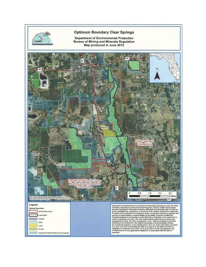
TABLE OF CONTENTS

                                                                                                                                      Page

     Contents
             TABLE OF CONTENTS .................................................................................................. 2
             I. MAPS / AERIALS ...................................................................................................... 4
             II. TABLES ...................................................................................................................... 4
             III. LIST OF ADDENDA.................................................................................................. 4
             LAND MANAGEMENT PLAN EXECUTIVE SUMMARY ........................................ 5
             ABBREVIATIONS AND ACRONYMS .......................................................................... 6

I.    MANAGEMENT PLAN OVERVIEW ................................................................................... 8
        A. INTRODUCTION ...................................................................................................... 8
        B. PURPOSE AND SCOPE OF PLAN ....................................................................... 12
        C. MANAGEMENT PROGRAM OVERVIEW ........................................................ 14
        1. Management Authority and Responsibility ........................................................... 14
        2. Property Goals and Objectives ................................................................................ 14
        3. Management Coordination ...................................................................................... 15
        4. Public Participation .................................................................................................. 20
        5. Other Designations ................................................................................................... 21

II. RESOURCE MANAGEMENT COMPONENT .................................................................. 22
       A. INTRODUCTION .................................................................................................... 22
       B. RESOURCE DESCRIPTION AND ASSESSMENT ............................................ 22
       1. Natural Resources ..................................................................................................... 27
       a. Topography ............................................................................................................... 27
       b. Geology ...................................................................................................................... 27
       c. Soils ............................................................................................................................ 28
       d. Minerals ..................................................................................................................... 29
       e. Hydrology .................................................................................................................. 33
       f. Natural Communities ............................................................................................... 34
       g. Designated Species .................................................................................................... 40
       h. Special Natural Features .......................................................................................... 40
       2. Cultural Resources ................................................................................................... 40
       C. RESOURCE MANAGEMENT PROGRAM ......................................................... 42
       1. Management Needs and Problems .......................................................................... 43
       2. Management Measures for Natural and Cultural Resources ............................... 44
       GOAL #1 – Property Definition and Security ............................................................... 44
       Objective #1:         Define property boundaries ............................................................... 44
       Objective #2: Mark property boundaries ................................................................... 45
       Objective #3: Improve or develop access .................................................................... 45
       Objective #4: Protect against infringements ............................................................... 45

                                                                            2
GOAL #2 – Protection of Renewable Resources ........................................................... 45
            Objective #1: Evaluate status of renewable natural resources ............................... 45
            Timber Surveys ................................................................................................................ 46
            Exotic Species Control ..................................................................................................... 47
            Arthropod and Disease Control ...................................................................................... 49
            GOAL #3 – Conservation of Nonrenewable Resources ................................................ 49
            Objective #1:       Conservation of unknown cultural resources ................................... 50
            Objective #2: Conservation of outstanding and unique natural resources .............. 51
            Objective #3:       Conservation of soil resources............................................................ 51
            Objective #4:       Conservation of water resources........................................................ 52
            GOAL #4 – Acquisition of Additional Resources and Considerations ....................... 52
            Objective #1: Increase Bureau staff .......................................................................... 53
            Objective #2:       Acquire lands to bolster the foundation and efficacy of the IHN
                system......................................................................................................................... 53
            Objective #3: Obtain “Preservation” status for Lease 3995 IHN lands in Polk
                County 2030 Comprehensive Plan .......................................................................... 53
            3. Research Needs ......................................................................................................... 53
            a. Previous and Current Research .............................................................................. 53
            b. Proposed Research ................................................................................................... 54
            4. Resource Management Schedule ............................................................................. 54
            5. Land Management Review ...................................................................................... 56

III. LAND USE COMPONENT ................................................................................................... 57
        A. INTRODUCTION .................................................................................................... 57
        B. EXTERNAL CONDITIONS ................................................................................... 57
        1. Existing Use of Adjacent Lands .............................................................................. 57
        2. Planned Use of Adjacent Lands .............................................................................. 58
        C. PROPERTY ANALYSIS ......................................................................................... 58
        1. Assessment of Use ..................................................................................................... 59
        a. Past Uses .................................................................................................................... 59
        b. Recreational Uses ...................................................................................................... 60
        c. Protected Zones......................................................................................................... 60
        d. Existing Facilities ...................................................................................................... 60
        2. Public Use and Recreation Resource Elements ...................................................... 60
        GOAL #5 – Determination of Public Recreation Usage ............................................... 61
        Objective #1: Evaluate lands to determine appropriate types and levels of
           recreational use ......................................................................................................... 61
        Objective #2: Designate areas where public recreational use could occur on Lease
           3995 lands without causing adverse impacts to natural or cultural resources ... 63
        Objective #3: Develop cooperative efforts with other groups to investigate
           potential for public recreational opportunities on IHN lands within Lease 3995
                        63
        D. CONCEPTUAL LAND USE PLAN ....................................................................... 63
        1. Potential Uses/Facilities ............................................................................................ 64
        2. Property Improvements ........................................................................................... 65

                                                                             3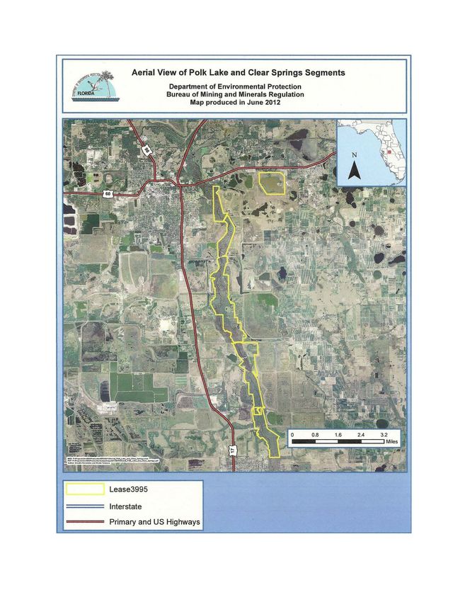
3.   Existing Use and Optimum Carrying Capacity ..................................................... 65
     4.   Optimum Boundary ................................................................................................. 65

I.   MAPS / AERIALS
       Vicinity Map                                                                                                     23
       Aerial Views                                                                                                     24
       Soils Maps                                                                                                       30
       Land Cover Maps                                                                                                  35
       Points of Interest Map                                                                                           41
       Optimum Boundary Maps                                                                                            67

II. TABLES
       Table 1 – Soil Types by Tract in Lease 3995                                                                      29
       Table 2 – Scheduled Focus Area by Year                                                                           55
       Table 3 – Evaluation of Potential Resource-Based Public Outdoor
                 Recreation or Other Public Use Activities on Lease 3995                                                61

III. LIST OF ADDENDA
        Addendum 1 - Acquisition History and Legal Description of Property                                              71
        Addendum 2 - References Cited                                                                                   78
        Addendum 3 - Soil Descriptions                                                                                  82
        Addendum 4 - Designated Species List                                                                            88
        Addendum 5 - Priority Schedule and Cost Estimates                                                               93
        Addendum 6 – Advisory Group Documentation                                                                       95
        Addendum 7 – DHR Cultural Management Procedures                                                                119
        Addendum 8 – Letter of Compliance with Polk County
                        Comprehensive Plan                                                                             123

                                                               4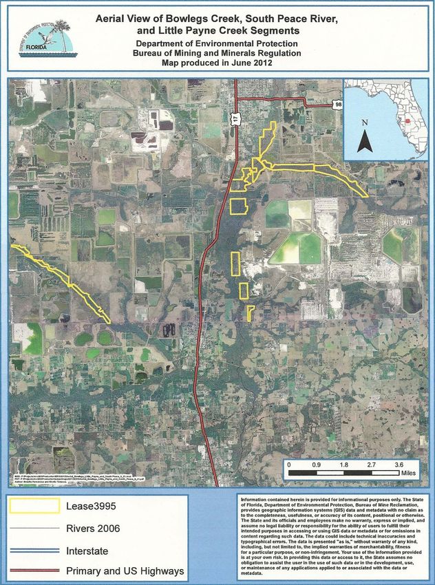
LAND MANAGEMENT PLAN EXECUTIVE SUMMARY
Lead Agency:      Florida Department of Environmental Protection, Division of Water Resource
                       Management, Bureau of Mining and Minerals Regulation
Common Name:     Integrated Habitat Network (IHN) Lands or “IHN Lands”
Location:        Polk County, Florida
Acreage Total:    4,864 acres

Land Cover                                                                   Percent
Classification                                   Acreage                     Coverage
Stream and Lake Swamps (Bottomland)               3,479                       71.5%
Abandoned Pasture                                   705                       14.5%
Freshwater Marshes                                  264                        5.4%
Lakes                                               176                        3.6%
Upland Hardwood-Conifer Mixed Forest                151                        3.1%
Upland Coniferous Forest                             39                        0.8%
Impoundment/Artificial Pond                          28                        0.6%
Institutional                                        19                        0.4%
Emergent Aquatic Vegetation                           2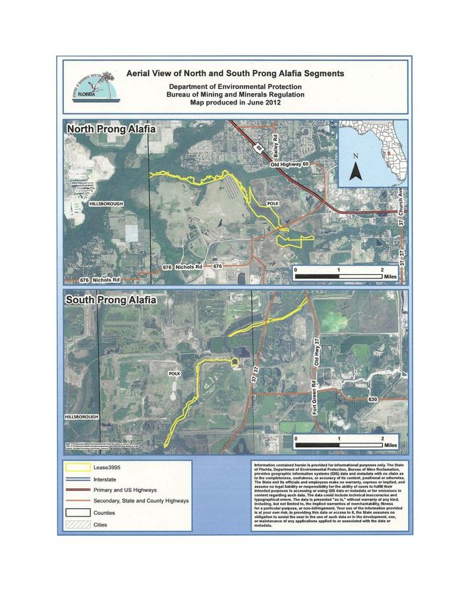
ABBREVIATIONS AND ACRONYMS

Agrico               Agrico Chemical Company
BMPs                 Best Management Practices
Board of Trustees    Board of Trustees of the Internal Improvement Trust Fund
Bureau               Bureau of Mining and Minerals Regulation, Division of Water Resource
                           Management, Florida Department of Environmental Protection
CARL                 Conservation and Recreation Land
CDA                  Coordinated Development Area
CHNEP                Charlotte Harbor Natural Estuary Program
Coastal Settlement   Coastal Petroleum Litigation Settlement Agreement
County               Polk County, Florida
DSL                  Division of State Lands, Florida Department of Environmental Protection
Department           Florida Department of Environmental Protection
DHR                  Division of Historical Resources, Florida Department of State
Division             Division of Water Resource Management, Florida Department of
                           Environmental Protection
EO                   Element Occurrence
Estech               Estech, Inc.
F.A.C.               Florida Administrative Code
FDEP                 Florida Department of Environmental Protection
FDOT                 Florida Department of Transportation
FFS                  Florida Forest Service, Florida Department of Agriculture and Consumer
                           Services
FFWCC                Florida Fish and Wildlife Conservation Commission
FGS                  Florida Geological Survey
FLUCFCS              Florida Land Use, Cover and Forms Classification System
FNAI                 Florida Natural Areas Inventory
FPTA                 Florida Paddling Trails Association
F.S.                 Florida Statutes
IFAS                 Institute of Food and Agricultural Sciences
IHN                  Integrated Habitat Network
IMC                  International Minerals & Chemical Corporation (now Mosaic
                           Fertilizer, LLC)
MFLs                 Minimum Flows and Levels
Mobil                Mobil Mining and Minerals Company
Mosaic               Mosaic Fertilizer, LLC
MSL                  Mean Sea Level
NGVD                 National Geodetic Vertical Datum
NRCS                 Natural Resources Conservation Service, U.S. Department of Agriculture
OAWP                 Office of Agricultural Water Policy, Florida Department of Agricultures and
                           Consumer Services
OGT                  Office of Greenways and Trails, Division of Recreation & Parks, Florida
                           Department of Environmental Protection
PBP                  Prescribed Burn Plan
PBS&J                Post, Buckley, Schuh, and Jernigan
PCPD                 Polk County Planning and Development
PCSB                 Polk County School Board
PREEN                Peace River Environmental Education Network
SCS                  Soil Conservation Service (now Natural Resources Conservation Service,
                           U.S. Department of Agriculture)

                                           6
SEGS          Southeastern Geological Society
SWFWMD        Southwest Florida Water Management District
SWUCA         Southern Water Use Caution Area
TFMA          Tenoroc Fish Management Area
TMDLs         Total Maximum Daily Loads
UF            University of Florida
USGS          United States Geological Survey
ZWI and CCI   Zellars-Williams, Inc. and Conservation Consultants, Inc.

                                    7
I. MANAGEMENT PLAN OVERVIEW
A. INTRODUCTION

The Coastal Petroleum Litigation Settlement Agreement (Coastal Settlement), finalized on
November 3, 1987, set up a matrix whereby five phosphate mining companies were required to
deed approximately 6,250 acres in various-sized tracts along the Peace, North Prong Alafia, and
South Prong Alafia river floodplains to the State of Florida for alterations made by the
companies in the State-owned natural channels of these rivers. The lands involved are
predominantly streams and rivers with adjacent floodplains, together with isolated parcels of
reclaimed uplands, all within the southern phosphate district. The five companies – Agrico
Chemical Company; American Cyanamid Company; Estech, Inc.; International Minerals &
Chemical Corporation; and, Mobil Mining and Minerals Company – were to conduct these
transfers over a period of 12 years, with the agreement mandating that the transfers be
accomplished on either a date or event positive. Through an elaborate procedure, the settlement
lands were to be transferred in fee to the Board of Trustees of the Internal Improvement Trust
Fund (Board of Trustees) through normal Division of State Lands (DSL) procedures and then
leased by the DSL to an appropriate managing agency.

One of the powers and duties of the Florida Department of Natural Resources, Division of
Resource Management as set forth in Section 370.02(3)(g), Florida Statutes (F.S.) was that
“…the division shall also perform functions including, but not limited to, preservation,
management, and protection of lands held by the State other than parks and recreational and
wilderness areas…” The Attorney General and the Florida Department of Natural Resources,
now the Florida Department of Environmental Protection (Department), identified the Division
of Resource Management, now the Division of Water Resource Management (Division) as the
entity to manage the lands transferred to the State that had not been leased to another agency.

In 1992, the Bureau published a guide entitled A Regional Conceptual Plan for the Southern
Phosphate District of Florida in which the largely undisturbed lands in the riverine floodplains
that were transferred to the State pursuant to the Coastal Settlement were to become the “core”
lands of the Integrated Habitat Network (IHN). The IHN is linear and diffuse in nature, covering
primarily undisturbed lands within the floodplains of the Peace, North Prong Alafia, and South
Prong Alafia river systems as well as some adjacent, isolated upland buffer lands. The IHN
component consists of a greenway network throughout the phosphate district that is designed to
connect with regional hubs and linkages such as the Green Swamp, Myakka River State Park,
and Charlotte Harbor. The adjacent reclaimed “buffer” lands, or Coordinated Development Area
(CDA), were to compliment and enhance the habitat value of the core lands. The CDA consists
of those lands outside the IHN that are to be or have been reclaimed for various, more intensive
land uses, which may include but are not limited to: intensive agriculture such as citrus or row
crops; semi-intensive agriculture such as pasture or silviculture; intensive development such as
power plants or other industrial facilities; and, semi-intensive development such as residential
and commercial complexes. While the long-term goals of the IHN are to enhance the regional
water quantity and quality while replacing and protecting natural communities, the goals of the
CDA are to protect these same water quantity and quality values while providing opportunity for
varied development.

                                              11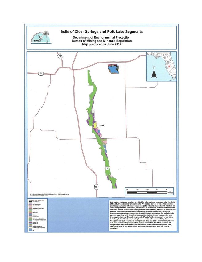
Managed properly, together these areas benefit the water quality and quantity in the area,
improve wildlife habitat, and serve as connections between the mining region’s rivers and
significant environmental features outside the southern phosphate mining region. The Bureau
and phosphate industry have long used a variety of “tools”, including reclamation, mitigation,
preservation, best management practices, less-than-fee conservation agreements, litigation
settlement lands, donated lands, and various land acquisition programs to accomplish the goal of
protecting wildlife habitat and water resources in the Peace, North Prong Alafia, and South
Prong Alafia River basins. The Bureau envisioned that the IHN plan would become part of the
“toolbox” as a guide for the reclamation of mined phosphate lands throughout the mining district
and began promoting the plan through numerous publications and meetings.

In October 1993, approximately 930 acres of State-owned Coastal Settlement lands bordering the
Peace River and Bowlegs Creek were leased to the Division in Lease 3995 and assigned to the
Bureau for management. In 1994, House Bill 2445 repealed Section 370.02 F.S. related to the
duties of the divisions of the Department of Natural Resources. Section 377.07, F.S., states “The
Division of Resource Management of the Department of Environmental Protection is hereby
vested with power, authority, and duty to administer, carry out, and enforce the provisions of this
law as directed in 1s. 370.02(3)”. Between 1993 and 2009, Lease 3995 was amended eight times
to include floodplain parcels on both sides of the Peace River north of Ft. Meade, floodplain
parcels along the South Prong Alafia River tract, parcels along the Peace and North Prong Alafia
Rivers, tracts along the upper Peace River north of Homeland and along the upper reaches of
Little Payne Creek, and Polk Lake east of Bartow. In May 2010, the Board of Trustees accepted
the transfer of title from the Williams Acquisition Holding Company, Inc. for approximately 770
acres of previously mined lands adjacent to the Tenoroc Fish Management Area (TFMA) near
Lakeland, FL; this tract is scheduled to be added to the TFMA Lease 3977 and included in the
management plan for that property so it is not included in this management plan for Lease 3995.

Because the lands within Lease 3995 are a complex mixture of diverse habitats and wildlife,
different lease and amendment requirements, and assorted management and monitoring needs,
current management activities within the IHN are incompatible with the current philosophies and
strategies of other land management agencies. The Bureau’s regulatory presence and familiarity
with the central Florida phosphate mining district, as well as the commitment and experience of
its staff, render it extremely qualified to provide, develop, conduct, assist, and monitor basic
management activities for long-term protection of these lands; it is also quite capable of
coordinating and supervising wide-ranging projects designed to improve habitat quality within
the Integrated Habitat Network lands in Lease 3995. The Department’s endorsement of the
Bureau’s work in the IHN provides further support of the Bureau’s involvement in active land
management.

B. PURPOSE AND SCOPE OF PLAN

This plan serves as the basic statement of policy and direction for the management of the
Integrated Habitat Network (IHN) lands within Lease 3995 as a part of the Division of State
Lands’ policy of providing stewardship of the more than 3.8 million acres of State-owned
conservation lands. It identifies the objectives, criteria, and standards that guide each aspect of

                                                12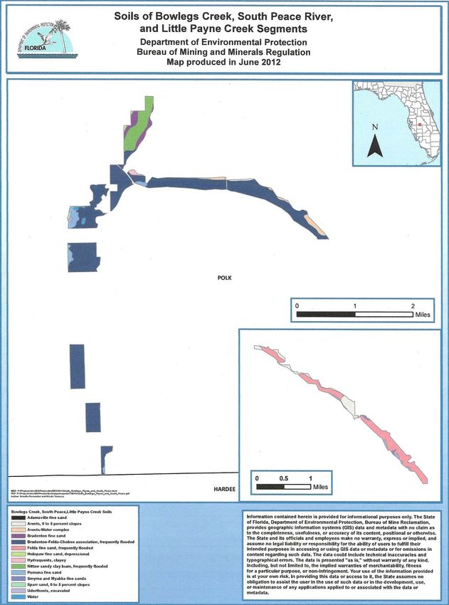
its management and sets forth the specific measures that will be implemented to meet
management objectives. This plan is intended to meet the requirements of Sections 253.034 and
259.032, Florida Statutes (F.S.), Chapter 18-2, Florida Administrative Code (F.A.C.), and is
intended to be consistent with the State Lands Management Plan. All development and resource
alteration actions encompassed in this plan are subject to the acquisition of appropriate permits,
easements, licenses, and other required legal instruments. Approval of this management plan
does not constitute an exemption for compliance with the appropriate local, county, state, or
federal agencies.

The plan consists of two interrelated components, with each component corresponding to a
particular aspect of the management of the property. The Resource Management Component
provides a detailed inventory and assessment of the resources of the property. Resource
management problems and needs are identified and specific management objectives are
established for each resource type. This component provides guidance on the application of such
actions as prescribed burning, exotic species control, and restoration of natural conditions. The
Land Use Component is the recreational resource allocation plan for the property. Based on
considerations such as access, regional population, and adjacent land uses, an assessment of the
property is made to determine any potential use areas and the types of facilities and possible
volumes of use to be needed or provided.

In the development of this plan, the potential of these IHN lands for both single-use and
multiple-uses were evaluated. Section 253.034(a), F.S., states that all submerged lands shall be
considered “single-use” lands, which are to be managed “for one particular purpose to the
exclusion of all other purposes, except that the using agency shall have the option of including in
its management program compatible secondary purposes which will not detract from or interfere
with the primary management purposes.” Submerged lands are to be managed primarily for the
maintenance of essentially natural conditions, the propagation of fish and wildlife, and limited
public recreation (such as canoeing/kayaking, bird and wildlife viewing) permitted at the
discretion of the managing agency.

Section 253.034(b), F.S., describes “multiple-use” management as “….the harmonious and
coordinated management of timber, recreation, conservation of fish and wildlife, forage,
archaeological and historic sites, habitat and other biological resources, or water resources so
that they are utilized in the combination that will best serve the people of the state, making the
most judicious use of the land for some or all of these resources, and giving consideration to the
relative values of the various resources.” These secondary management purposes (“multiple
uses”) were considered within the context of the Division’s statutory responsibilities and an
analysis was made of the resource needs and values of the property.

This analysis considered the natural and cultural resources, management needs, and public use
opportunities. For Lease 3995, it was decided that the primary concern would be the
preservation and protection of the water resources, wildlife corridors, and habitat within the
lease, but other uses would be considered on a case-by-case basis for each of the seven parcels in
the lease if these uses could be accommodated so that they would not interfere with the primary
purpose. This analysis is presented in further detail in Part III, Land Use Component.

                                                13
C. MANAGEMENT PROGRAM OVERVIEW
1. Management Authority and Responsibility
In 1989, an amendment to Chapter 370.02(3), Florida Statutes, provided that the Florida
Department of Natural Resources, Division of Resource Management (now the Florida
Department of Environmental Protection, Division of Water Resource Management) “…shall
perform functions including, but not limited to, preservation, management, and protection of
lands held by the state other than parks and recreational and wilderness areas.” During the
negotiations in the mid-1980s that lead to the Coastal Settlement, the Division of Resource
Management was identified by the Attorney General and the Department as the entity to manage
lands to be transferred to the State and not leased to another agency. In 1994, House Bill 2445
repealed Section 370.02, F.S., related to the duties of the divisions of the Department of Natural
Resources. Section 377.07, F.S., states that “The Division of Resource Management of the
Department of Environmental Protection is hereby vested with power, authority, and duty to
administer, carry out, and enforce the provisions of this law as directed in 1s.370.02(3).”
In 1999, an amendment to Chapter 378.035, F.S. (Department responsibilities and duties with
respect to Nonmandatory Land Reclamation Trust Fund) further codified the Division’s land
management role and provided for “…funding basic management or protection of reclaimed,
restored, or preserved phosphate lands”. In 2000, a Legislative Budget Request was approved
for a $200,000 Special Categories, Division of Water Resources budget line item to implement
the responsibilities from both statutes. The $200,000 line item has remained viable through the
2012-2013 budget (note that this amount is divided among several leased properties that are
managed or co-managed by the Bureau).
The lands in the IHN that have been acquired by the State in fee simple title through the Coastal
Settlement and donations were transferred to the Board of Trustees through normal DSL
procedures. The DSL then leased these lands to the Department’s Division of Resource
Management, the Bureau’s parent division, which was determined to be the appropriate
management agency because of its statutory management authority, regulatory presence, and
familiarity with the central Florida phosphate district.
2. Property Goals and Objectives
Using the goals, objectives, and priority management activities planned for the Lease 3995 IHN
Lands, estimates were developed for the funding and staff resources needed to implement the
management plan. Funding priorities for all state property management and development
activities are reviewed each year as part of the Division legislative budget process. The
Division, based in part on input from the Bureau, prepares an annual legislative budget request
based on the priorities established for the planned activities. The Bureau also pursues a wide
range of other funding and staffing resources (such as grants, volunteers, and partnerships with
other agencies, local governments, and the private sector – see Item 3 below) to supplement
normal legislative appropriations to address unanticipated needs. The ability of the Bureau to
implement the specific goals, objectives, and priority actions identified in this plan will be
determined by the availability of funding resources for the purposes described in this document.
14The concept of “basic” land management as set forth in Subsection 378.035(6)(a), F.S., which
deals with preservation, management and protection of lands other than parks, recreation and
wilderness areas, was strongly influenced by Chapter 370, F.S. and assumed that any lands to be
made available to the public would be managed by an entity experienced in providing such
services. “Basic management” to be provided to those lands being used for protection of wildlife
habitat and water resources was defined by Cates and Woodard (1999) as:
1. Identification of property through legal description
2. Determination of boundaries via surveying and mapping
3. Establishment of access
4. Assessment of natural and cultural resources
5. Acquisition of GPS coordinates
6. Demarcation of boundaries
7. Inspection of property at a minimum once per year
8. Resolution of infringements
9. Installation of fencing or other impediments in high infringement areas
10. Management of nuisance/exotic plant infestations
In its management of Lease 3995, the Bureau seeks a balance between the goals of maintaining
and enhancing natural areas and providing recreational opportunities for the public. Natural
resource management activities are directed towards management of natural systems and the
restoration or enhancement of disturbed systems to return them towards more natural conditions.
Providing public access to and within Lease 3995 and providing recreational opportunities (such
as canoeing/kayaking and wildlife observation) would provide a reasonable balance with the goal
of creating and maintaining natural habitats and conditions. Program emphasis is on the
preservation of natural areas and the restoration and enhancement of disturbed sites, with a
secondary aim of developing potential aesthetic, recreational, and educational opportunities on
site.
The goals and objectives discussed later in this management plan describe the Division’s long-
term plans for managing the Lease 3995 IHN Lands. The Bureau developed goals and objectives
for inclusion in this plan that were meaningful and practical, thus ensuring that the goals and
objectives would be relevant over time.
3. Management Coordination
Funding for restoration and management of Lease 3995 lands is limited, so although it is
possible, it is very unlikely that sufficient monies will be available for private managers to
facilitate the restoration or management of these lands. To overcome this, the Bureau has been
or is currently involved in numerous multi-party projects and will continue to participate in these
cost-effective, cooperative efforts with other agencies and interests (many of which are listed
below) to benefit the resources of the Peace, North Prong Alafia, and South Prong Alafia
watersheds:
15Central Florida Ecotours – Provides information to the public about the Integrated Habitat
Network and the Peace River watershed during children’s environmental festivals that are funded
totally by the organization.
Charlotte Harbor National Estuary Program (CHNEP) – The CHNEP is a partner in education
programs and research about environmental influences that affect the Peace River watershed.
CHNEP and FDEP staffs continue to consult and coordinate on watershed management
strategies, including public meetings supporting common goals for land and water management
objectives. Bureau staff has successfully procured grants through the CHNEP to establish a
stormwater pond community education project in Bartow and to secure funding for the
presentation of the Historic Kissengen Spring State Marker.
City of Bartow – Grant coordination with CHNEP for stormwater pond community education
garden; coordination with Bartow Chamber of Commerce to conduct requested visits to the
Upper Peace River historic and geologic site.
City of Ft. Meade - Assistance with land use planning reviews for City future development
involving Bowlegs Creek tracts; coordination and development of City canoe launch as part of
the State Blueway.
City of Mulberry – Community revitalization coordination involving improvements to North
Prong Alafia River tributaries and lands that affect water and wildlife resources of local IHN
lands.
City of Winter Haven – Assistance with Water Sustainability Plan affecting water quality and
quantity within the Upper Peace River IHN lands; cooperative development of Upper Peace
River Blueway designation and cooperative support for Florida Paddling Trails Association.
Clear Springs Land Company – Ongoing cooperative planning and development of conservation
easements and protection of natural resources adjacent to Lease 3995 along the Upper Peace
River.
Cooperative Invasive Species Management Areas – Bureau staff works closely with this regional
working group in addressing invasive plant management on State lands.
Florida Department of Agriculture & Consumer Service, Florida Forest Service – Cooperative
planning and implementation of prescribed fire programs, emergency fire suppression,
reforestation efforts, and plant procurement and research for improved BMPs involving
agricultural practices.
Florida Department of Environmental Protection, Division of Historical Resources – Curation of
artifacts and ongoing assessment and cataloging of new historical resources found on State lands.
Florida Department of Environmental Protection, Division of Law Enforcement - Cooperative
enforcement programs providing for education, investigation, and prosecution of criminal acts on
State lands.
16Florida Department of Environmental Protection, Division of Recreation and Parks –
Cooperative educational exchanges and land management support for control of invasive plants.
Florida Department of Environmental Protection, Office of Greenways and Trails – Cooperative
programs involving planning and development of public trails associated with local waterways
and communities near IHN lands, such as the Upper Peace River Blueway and Homeland
Heritage Canoe Launch.
Florida Fish and Wildlife Conservation Commission – The Bureau currently coordinates with the
FFWCC on the control of invasive aquatic and upland plants on its public conservation lands and
waterways. In addition, Bureau staff will also work with the FFWCC to develop a Wildlife
Management Strategy that will address all potential fish and wildlife species on the area, with
specific focus on imperiled species and associated management prescriptions including species
surveys and monitoring where appropriate, for their habitats and their sustainability based on
site-specific population data.
Florida Geological Survey – Shared hydrogeologic studies focused on restoration of the Upper
Peace River.
Florida Industrial and Phosphate Research Institute – Cooperative efforts on ongoing research
into reclamation activities on Lease 3995.
Florida Natural Areas Inventory – Collaborative mapping of natural element occurrences and
invasive species.
Florida Paddling Trails Association (FPTA) – Joint involvement in the creation of the Florida
Paddling Trails Blueway on the Peace River from Bartow to Zolfo Springs. Bureau staff also
serve as “riverkeepers” for the Upper Peace River on behalf of the FPTA while FPTA members
provide year-round volunteer assistance with river clean-ups and natural resource protection.
Florida Rangers – The Florida Rangers is a non-profit entity whose volunteers perform land
management activities on State lands managed by the Bureau on the Peace River near Bowlegs
Creek. The Rangers maintain firebreaks, mow, and monitor more than 100 acres of State lands
that are immediately adjacent to their 80-acre property known as Camp Wilderness.
Florida Wildlife Corridors Expedition – Bureau staff coordinates regional interest and
involvement in the ongoing development of the IHN which is an integral part of the conservation
lands that are the focus of the Statewide Wildlife Corridor development process.
Friends of Kissengen Spring – Comprised of laypersons, scientists, historians, and others
interested in the fate of this spring and the historic site located on Lease 3995 lands, the Friends
of Kissengen Spring and Bureau staffs coordinate on historical, archaeological, hydrogeological,
and other studies of the spring and historic site.
17FWC Ridge Rangers Volunteers – Assist with exotic plant removal, primarily Chinese tallow, in
the Clear Springs segment
Keep Polk County Beautiful – Partnership clean-ups and special projects development involving
local communities; Department staff was awarded “Volunteer of the Year” award in 2011 by this
organization.
Mosaic Fertilizer, LLC – Collaborative effort to develop special restoration projects to create
ecologic benefits that enhance the environmental quality of lands adjacent to Lease 3995 IHN
lands; special projects include mitigation plantings, Conservation Easement enhancements
related to off-site mine mitigation requirements, and cooperative public outreach promoting
development of regional wildlife corridors.
Northern Bobwhite Quail Conservation Initiative – Bureau staff coordinates with the Initiative
on the collection and exchange of census data, habitat conditions, and management
recommendations to assist with the recovery of natural bobwhite quail populations in the area.
Peace Creek Alliance – Created to foster sustainable water resource management by linking land
development with natural systems restoration; Bureau staff continues to interact with Alliance
members in developing water quality and quantity standards and expanding wildlife habitat
connections to the IHN in the southern phosphate district.
Peace River Environmental Education Network (PREEN) – Organization formed by the
Bureau’s Environmental Resources staff which is dedicated to creating a watershed network of
citizens, educators, and resource managers to foster awareness of watershed environmental
issues and solutions; group also intends to develop and site a premier Environmental Education
Center in the Upper Peace River region. From 2000 to 2010, PREEN was funded by SWFWMD
and CHNEP which cooperated with Bureau staff to host meetings; in 2011, CHNEP assumed the
primary role of guiding the PREEN watershed network and continues to partner with Bureau
staff to foster key public outreach programs affecting both the Peace River watershed and Lease
3995 IHN lands.
Polk County Friends of the Parks – Coordination of matching grant procurement for SWFWMD
Community Education Grant for the North Prong Alafia River watershed signage installation and
nature reserve development.
Polk County Historical Association and Polk County Historical Museum – The Bureau’s
Environmental Resources staff partnered with this association and the museum to create two
historic products associated with Kissengen Spring, which is located on Lease 3995 lands: a)
Staff produced and coordinated the installation of the Historic Kissengen Spring State Marker in
cooperation with the DHR’s State Historical Marker Program; and, b) staff co-produced the Oral
History DVD entitled “Remembering Kissengen Spring”, featuring keynote speaker Cynthia
Barnett, in cooperation with Polk Government TV.
Polk County Parks and Natural Resources Division – The Bureau works closely with this group
on cooperative land management projects including prescribed fire application and monitoring
18the environmental quality of area habitats. Cooperative investigations of environmental impacts
on the Upper Peace River regarding public recreation and safety and environmental evaluations
of watershed TMDLs are regularly conducted.
Polk County Office of Planning and Development – Bureau staff works collaboratively with the
agency by providing technical and regulatory information about phosphate-mined lands within
the county and the PCPD works with Bureau staff to include the Integrated Habitat Network
lands within the Polk County Conservation GreenPrint Masterplan.
Polk County School Board – Bureau staff works with the Polk County School Board to
cooperatively manage State lands along the Peace River that are subleased to the School Board.
Staff also coordinates with the School Board Office of Academic Rigor to plan in-school
visitations for environmental education programs such as the Southeastern Geologic Society
Maps in Schools Project.
Polk State College – Bureau staff worked with the college’s Geology Department to develop a
laboratory program for students to visit the Upper Peace River karst area twice each year,
enabling them to experience these unique hydrogeologic features.
Sierra Club – Provides ongoing consultation and recommendations for priority public interest
concerns about protection of local natural resources.
Southeastern Geological Society (SEGS) – Bureau staff and SEGS representatives have (a)
developed a program involving visits to the Upper Peace River for professional geologists and
members of other scientific organizations who study karst features; (b) created a project called
“Tapestry in Time and Terrain” using USGS/SEGS Maps in Schools; and, (c) encouraged the
pursuit of geologic studies by presenting the Map program to regional high school classes and
science teachers. SEGS leaders also provide technical consultation to Bureau staff regarding
geologic issues affecting land management programs in the Upper Peace River.
19Southwest Florida Water Management District – Coordinated efforts regarding ongoing Water
Resource Recovery plan implementation for Minimum Flows and Levels associated with the
Upper Peace River; cooperative information exchanges and consultations for permitting
development, compliance, and enforcement.
U.S. Department of Agriculture, Natural Resources Conservation Service (NRCS) – Cooperative
educational training and development of programs associated with BMPs for conservation lands.
U.S. Geological Survey (USGS) – Bureau staff works closely with USGS technical and field
staff to monitor hydrologic and geologic conditions of the Peace River; Bureau staff also
provides logistical support to scientific studies, offers background information about local
environmental histories and conditions, and monitors field gauges in Lease 3995 waterbodies.
University of Florida, Geoplan Center – Bureau staff coordinates events with Geoplan personnel
to facilitate completion of the Integrated Habitat Network and to foster cooperation among
landowners, agencies, nongovernmental organizations, and others working to create the Florida
Wildlife Corridor project. Bureau staff continues to work with Dr. Tom Hoctor to foster regional
interest in the dedication and mapping of conservation lands to make important regional wildlife
corridor connections with the Bureau’s Integrated Habitat Network.
University of Florida, Institute of Food & Agricultural Sciences (IFAS) – In addition to
providing the Bureau with required technical training for Pesticide Application licensing, IFAS
and Bureau staff cooperate on invasive plant research, plant identification, and plant cultivation
practices that assist with land restoration techniques. Bureau staff recently assisted with the
IFAS-sponsored 2012 Polk County Water School by developing a syllabus and speaker bureau to
assist regional public officials and citizens learns about water resources and FDEP programs that
improve water quality and conservation.
University of Florida, School of Forest Resources and Conservation (SFRC) – Bureau staff has
supported SFRC researchers with the development of an experimental biofuel tree plantation.
Bureau staff also supported undergraduate projects designed to provide technical information
about the use of short-rotation woody crops to inhibit the spread of cogongrass. Other
cooperative research projects with the SFRC include supporting the creation of Florida Wildlife
Corridors through its Integrated Habitat Network concept, working with the late Dr. L. D. Harris
to foster regional awareness of the need for wildlife movement corridors.
University of South Florida (USF) – Bureau staff works with USF staff to facilitate graduate
student studies pertaining to restoration of mined lands. Published graduate theses include the
works of Raina O’Neil on amphibian biology in natural and reclaimed wetlands and Chrysa
Mitrika’s work on comparative water quality in reclaimed and natural lakes. Bureau staff also
hosts special USF Geology Class visits to the Upper Peace River karst areas.
4. Public Participation
20The Bureau conducted a combined public workshop and Advisory Group meeting in Lakeland,
FL on August 9, 2012 to discuss the draft Lease 3995 IHN Lands Management Plan; details of
this meeting are provided in Addendum 6. After revising the management plan to incorporate
appropriate comments and recommendations, the Bureau presented the Lease 3995 Management
Plan to the Acquisition and Restoration Council at its December 14, 2012 meeting.
5. Other Designations
The Lease 3995 IHN Lands are not within an Area of Critical State Concern as defined in section
380.05, F.S. and currently are not under study for such designation. The lands within Lease
3995 are not a component of the Department’s Office of Greenways and Trails (OGT) Trail
System but the waters in the Peace River portion of the lease form the upper portion of a
Designated Paddling Trail (http://www.dep.state.fl.us/gwt/guide/paddle.htm)
No waters within the property have been designated as Outstanding Florida Waters, pursuant to
Chapter 62-302, F.A.C. The Lease 3995 IHN Lands are not an aquatic preserve as designated
under the Florida Aquatic Preserve Act of 1975 (section 258.35, F.S.). Surface waters on this
property are classified as Class III waters by the Florida Department of Environmental
Protection. The Lease 3995 IHN Lands have been included in the Southern Water Use Caution
Area, a 5,100 square mile area including all or part of eight counties in west-central Florida that
has been identified by the Southwest Florida Water Management District (SWFWMD) as an area
where water resources are or will become critical in the next 20 years (SWFWMD, 2006).
21II. RESOURCE MANAGEMENT COMPONENT
A. INTRODUCTION
The Division of Water Resource Management has implemented resource management programs
throughout the State for the preservation of representative examples of natural and cultural
resources of statewide significance under its administration. This component of the management
plan describes the natural and cultural resources of the Lease 3995 property and identifies the
methods that will be used to manage them. The stated management measures in this plan are
consistent with the Division’s overall mission in ecosystem management.
The Bureau’s main goal of natural resource management in Lease 3995 is to restore or enhance
and then maintain, to the extent possible, the natural processes that shaped the structure,
function, and species composition of Florida’s diverse natural communities as they originally
existed prior to any man-made disturbances. In the case of the Lease 3995 IHN Lands, the
emphasis of natural resources management is on the restoration or enhancement of lands
adversely impacted by the activities of agriculture and phosphate mining.
The management goal of the cultural resources on Lease 3995 is to preserve and protect sites and
objects that represent all of Florida’s cultural periods as well as significant historic events or
persons. This goal may require active measures to stabilize, reconstruct, or restore resources that
may be discovered on lease lands.
Because the Division’s properties are often components of larger ecosystems, their management
is often affected by conditions and events that occur beyond the property boundaries.
Management on State-owned property is implemented through a resource management
evaluation program (to assess resource conditions, evaluate management activities, and refine
management actions), a review of local comprehensive plans, and a review of permit
applications for impacts to this property and adjacent lands.
B. RESOURCE DESCRIPTION AND ASSESSMENT
The aggregation of properties comprising the Integrated Habitat Network in general and Lease
3995 in particular is located within the southern phosphate district in west central Florida (see
Vicinity Map). The common name, previous or current owner, acreage, means of acquisition,
and status of each of the seven tracts in Lease 3995 are described below. Due to the diverse and
complex nature of the acquisition of properties in Lease 3995, the original lease, the eight
amendments, three subleases, and one related lease are extremely large and intricate documents.
These 13 documents are comprised of 410 pages, 250 of which contain the legal descriptions of
all the lands within the seven parcels in this lease. For this reason, copies of these documents are
not provided in this addendum but are available from the Bureau upon request.
(1) The North Prong Alafia River tract is part of the Mobil Mining and Minerals Company
(Mobil) portion of the Coastal Settlement and consists of approximately 218 acres. This tract is
located along the North Prong Alafia River west of Mulberry and south of State Road 60 in the
vicinity of the Nichols Mine. The boundary was surveyed but not marked in 2005.
2223
Aerial View of North and South Prong Alafia Segments
                                             Department of Environmental Protection
                                            Bureau of Mining and Minerals Regulation
                                                  Map produced in June 2012

r::::::::::::-   Lease3995
                                                                     ~formation contained herein Is provided for Informational purposes only. The State
                                                                     of Florlda, Department of Environmental Protection, Buruu of Mline ReclamatJon,
                                                                     provides geographic Jnfonnatlon system s (GIS} data and met1d1ta with no clalm as
                                                                     to the completeness, usefulness, or accunicy of Its content, poshlonaJ or otherwise.
                 Interstate                                          The State and Its offlclals and itmployees make no warranty, express or Implied, and
                                                                     assume no legal flabhlty or responslbllky for the ablffl:y of users to futftll their
                 Primary and US Highways                             intended purposes In accenlng or using GIS data or metadata or for omissions in
                                                                     content regarding such data. The d.ta could Include technical Inaccuracies and
                 Secondary, State and County Highways                typographical errors. The dat1 l.s presented "'H Is,.. ..vlthout warranty of any kind,
                                                                     including, but not limited to, the Implied wunntles of merchantablity, fltness
                                                                     for a particular purpose, or non-Infringement. Your use of the lnfonnation provided
                 Counties                                            Is at your own risk. In providing this data or access to It. the State assumes no
                                                                     obligation to assist the user In the use of s uch d ata orln the development, use,
                                                                     or maintenance of any applications applied to or usoclated with the data or
                 Cities                                              meta data.

                                                              24
Aerial View of Polk Lake and Clear Springs Segments
Department of Environmental Protection
Bureau of Mining and Minerals Regulation
Map produced in June 2012
L Lease3995
Interstate
Primary and US Highways
2526
(2) The South Prong Alafia River tract, another portion of the Coastal Settlement lands that was
owned by the Cytec Brewster Phosphates, Inc., is located west of State Road 37 within the
Haynsworth Mine along the South Prong Alafia River. This tract is approximately 116 acres in
size and is currently patrolled by Bureau staff to assess its status. Boundary surveying and
marking have not been completed.
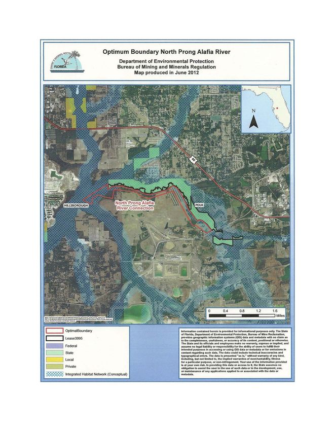
(3) The Clear Springs tract, originally part of the IMC Phosphates Company (IMC, now part of
Mosaic Fertilizer, LLC) portion of the Coastal Settlement, is a 2,538-acre area that stretches
from south of State Road 60 to north of County Road 640 along the Peace River in the vicinity of
the former Clear Springs Mine. The boundary delineation and marking of the portion north of
County Road 640 were completed in 2006, while surveying and partial boundary markings have
been completed south of the road.
(4) The Polk Lake tract was donated to the State in fee simple by Mosaic Fertilizer, LLC
(Mosaic) in 2009. This tract is approximately 393 acres in size and is located east of the City of
Bartow on the south side of State Road 60. The parcel was surveyed in 2008.
(5) The Bowlegs Creek tract, part of the Estech, Inc. (Estech) portion of the Coastal Settlement,
is located along Bowlegs Creek and its confluence with the Peace River south of Ft. Meade.
This 1,068-acre tract was partially surveyed in 2005 but has not been demarcated. The Florida
Rangers, Inc., a church youth group, aids management activities through a formalized volunteer
organization agreement with the Bureau.
(6) The South Peace River tract, part of the Mobil portion of the Coastal Settlement, is located
along the Peace River between Ft. Meade and Bowling Green. This tract is approximately 232
acres in size and is surrounded by the active South Ft. Meade Mine owned by Mosaic Fertilizer,
LLC (Mosaic). The boundary of this parcel has not been surveyed or marked.
(7) The Little Payne Creek tract was originally part of the Coastal Settlement lands owned by
Agrico Chemical Company (Agrico), which is now part of Mosaic Fertilizer, LLC. This tract,
approximately 299 acres in size, is located southwest of Ft. Meade is surrounded by Mosaic’s
active Payne Creek Mine. Surveying and boundary delineation have not been conducted.
1. Natural Resources
a. Topography
Lease 3995 is in the Central Highlands physiographic province, mainly on the Polk and Lake
Uplands. Elevations within Polk County range from 50 to 305 feet above National Geodetic
Vertical Datum (NGVD) with the lowest elevation in the Kissimmee River Valley and the
highest along the crest of the Lake Wales Ridge. Elevations in the Polk Upland range generally
between 100 and 130 feet above MSL (SCS, 1990); in Lease 3995, the topography varies widely
in the seven disjunct parcels located in and near the floodplains of the Peace River and the North
and South Prongs of the Alafia River. There are no beaches or dunes within Lease 3995.
b. Geology
27The U.S. Geological Survey has identified nine geologic units in Polk County, Florida (USGS,
2012); of these, the three most prevalent are:
1) Reworked Cypresshead sediments (Pliocene/Pleistocene): Covering 34% of the surface, this
unit is the result of post-depositional reworking of the Cypresshead Formation, which occurs
only in peninsular Florida and eastern Georgia and forms peninsular highlands from northern
Nassau County southward to Highlands County. Original fossil material is not present in the
sediments although poorly preserved molds and casts of mollusks and burrow structures are
occasionally present, documenting the marine influence of the depositions (USGS, 2012).
2) Hawthorn Group, Peace River Formation, Bone Valley Member (Miocene/Pliocene):
Covering 22% of the surface, the Bone Valley Member (originally the Bone Valley Formation)
occurs in a limited area on the southern part of the Ocala Platform in Hillsborough, Polk, and
Hardee Counties. Throughout its extent, the Bone Valley Member is a clastic unit consisting of
sand-sized and larger phosphate grains in a matrix of quartz sand, silt, and clay in a highly
variable lithology. Mollusks are found as reworked, often phosphatized casts. Vertebrate fossils
occur in many of the beds within the Bone Valley Member, with silicified corals and wood
occasionally present and shark’s teeth often abundant. The Bone Valley member is an extremely
important, unique phosphate deposit and has provided much of the phosphate production in the
United States during the twentieth century (USGS, 2012). Polk County contains more individual
fossil recovery sites than any other county due to phosphate mining activities in this member;
representative vertebrate fossils that have been collected include: turtles, crocodiles, horses,
camels, deer, dolphins, seals, whales, mammoths, mastodons, camels, and elephants (FIPR,
2012; USGS, 2012; Wikipedia, 2012).
3) Undifferentiated sediments (Pleistocene/Holocene): Covering 21% of the surface, these
sediments consist of siliciclastics, organics, and freshwater carbonates and are found in alluvial
and floodplain deposits as well as in ridges, dunes, and terraces. Clay or mud, beach sand, silt,
gravel, peat, and sand all comprise the lithology of this geologic unit (USGS, 2012).
After Kissengen Spring (a second magnitude spring) ceased continuous flow in 1950 due to
over-pumping of groundwater in the Peace River watershed, the karstic geology underlying the
Upper Peace River was subjected to accelerated sinkhole development as surface water drained
into the lowered groundwater system (Peek, 1951; PBS&J, 2007). These sinkholes and karst
features are present in the Peace River channel and floodplain and have been well-documented
over the past few decades. As many as 150 to 200 sinkholes may exist between Bartow and Fort
Meade and it has been speculated that at least half of these would not have occurred had the
potentiometric surface remained at its 1949 levels (Patton, 1981; Metz and Lewelling, 2009).
Most of the sinkholes are larger than 9-feet in diameter and the largest, Gator Sink, is 100-feet in
diameter and exposes the Floridan Aquifer System. Hydrologic and geologic impairments have
also adversely affected historic cypress forests that once covered the karstic floodplain, likely
caused by the combined effects of the lowered water table and the unstable clayey substrates
(Cook, 2007).
c. Soils
28You can also read