Seaborne trade and Field trials with Roman Vessels on Rhine, Moselle and Danube
←
→
Page content transcription
If your browser does not render page correctly, please read the page content below
Seaborne Trade and Field Trials with Roman Vessels
                 on Rhine, Moselle and Danube

                                                Christoph Schäfer

As Alan Bowman and Andrew Wilson have shown, new impulses and further insights
into the character and nature of the ancient economy can be achieved primarily through
quantification.1 With regard to Roman long-distance trade, however, valid data on the
efficiency and resilience of the trade routes are a necessary prerequisite for quantifying
analyses. Only on such a basis can new insights be gained into the transaction costs and
potential of individual trade goods. One important aspect of this is the oil trade with
Roman Germania. As shown by the absolute dominance in the archeological record of
oil amphorae of the Dressel 20-type with an approximate capacity of about 70 kg, Olive
oil for the German provinces originated almost exclusively in the Baetica.2
    A first indication of the order of magnitude of the annual oil deliveries is provided by
the Roman military. José Remesal-Rodríguez assumes an annual consumption of 1,370
oil-filled Dressel 20-amphorae per legion. Th. Kissel has calculated a supply requirement
of 11,500 amphorae for the 50,000 strong army in Britain.3 For the German provinces,
this means that the legions and auxiliary units on the Rhine border alone would have
had an annual oil requirement of approximately 23,000 amphorae.4
    The route via the Rhône, Saône and Moselle rivers is considered one of the main
routes for trade traffic and the supply of the military camps and civil settlements on the
Rhine.5 From the Saône, goods had to be transported by cart over land to the Moselle.6
With regard to the road link between Chalon-sur-Saône and the Moselle, the generally
postulated route crosses the Plateau-de-Langres, which would have involved a distance
of almost 240 km for the shortest route with Épinal as the destination.7 However, the
main road from Langres to Metz meets the Moselle 6 km upstream from Pont-à-Mous-
son at Scarponna (Dieulouard), at which point the river was already navigable. The
distance via Langres to Pont-à-Mousson would have been over 270 km, the connection
to Metz a good 300 km.8 With regard to the relation of sea, river and land transport, it
is necessary to calculate with the main route and thus a distance of 300 km. There was
an alternative to the Rhône-Saône-Moselle route: the sea route via the Atlantic, across
the Bay of Biscay to the mouth of the Rhine and then, after a single transhipment, up
the Rhine.

Atlantic route

Total distance:                                                  3010 km
Distance between Gades and Rhine estuary (across Bay of Biscay): 2480 km
Distance travelled upriver on Rhine until Mogontiacum9:530 km
Instances of reloading or transshipping:                               1
Published in: Thomas Schmidts – Martina Seifert (Eds.), New Approaches to Seaborne Commerce in the Roman Empire,
Panel 5.17. Archaeology and Economy in the Ancient World 24 (Heidelberg, Propylaeum 2022) 47–54. DOI: https://doi.org/10.11588/
propylaeum.1038.c14309
48 Christoph Schäfer
Rhône-Saône route
Overland transport Chalon-sur-Saône-Metz (1780:303:803)
Total distance: 2886 km
Distance between Gades and Rhône estuary in Arelate: 1780 km
Distance of overland transport between Chalon-sur-Saône and Metz: 303 km
Distance of river transport (Rhône, Saône, Moselle, Rhine10):803 km
Instances of reloading or transshipping: 311
In order to be able to estimate the journey times approximately, data from reconstructed
Roman military ships of the Oberstimm 1 (Victoria) and Mainz A (Lusoria Rhenana)
types, which were recorded with an electronic nautical measuring system, were used.
Even in the age of GPS, it is not enough to measure the journey of a ship over ground.
In order to obtain valid data, the displacement of the vessel due to current and wind
(drift) must be deducted from the GPS results. Unfortunately, tests with the first full
scale reconstruction of a Roman merchant ship (Bissula) on the Moselle, to be conducted
by the University of Trier, are still in their infancy. However, in the course of the experi-
ments with the three reconstructions of ancient military ships mentioned above, similar
sailing characteristics could be investigated and approximate results gained.
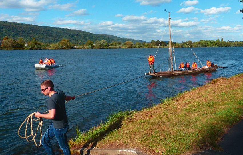
Fig. 1: Field tests with the Victoria (Oberstimm 1)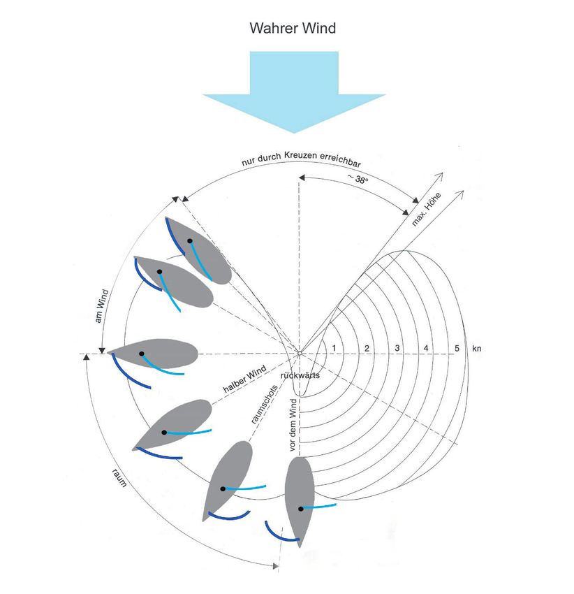
Seaborne Trade and Field Trials with Roman Vessels   49

      Fig. 2: Polar plot of a modern sailing yacht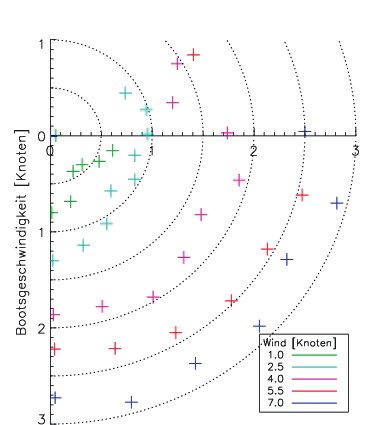
50                                Christoph Schäfer

   For this purpose, astrophysicists from the University of Hamburg and the Harvard-
Smithsonian Center of Astrophysics have developed and adapted the NX-2 measuring
suite manufactured by Silva-Nexus. Originally developed for the America’s Cup, the
adaptation of this combination of hardware and software allowed for an accurate mea-
surement of Roman ship reconstructions’ performances and the drift-adjusted values
for direction and speed under sail could be determined.12 The sailing characteristics of
any given ship is typically represented as a polar plot; the preceding example (fig. 2) is
from a modern sailing yacht.
   For the Oberstimm 1-type vessel, dated around 100 AD, such a plot looks as in fig. 3.
   Investigations have shown that, taking into account the occurrence of drift due to
current and wind, the square sail, which was typical of antiquity and also predominant
in the Middle Ages, can be sailed not only downwind or bulkheaded, but also on a half-
wind course and even slightly upwind.
   On the basis of the sailing data and taking into account today’s wind conditions,
which largely correspond to those of the Roman Empire, the following calculations can
be made.13

               Fig. 3: Polar plot of Oberstimm 1 (late 1st/early 2nd c. AD)
Seaborne Trade and Field Trials with Roman Vessels 51
Atlantic route (3010 km in total)
Time travelled 42.5–57 days
Travel time by sea (Gades-Rhine estuary) 16.5–22 days
Travel time by river (upriver to Mainz) 26–3 5 days
Instances of reloading or transshipping: 1
Rhône-Saône route (2886 km in total, via Plateau de Langres)
Time travelled 74–103.5 days
Travel time by sea (Gades-Rhône estuary) 15–20 days
Travel time by river (Rhône, Saône, Moselle) 40–53,5 days
Travel time overland (Chalon-sur-Saône-Metz) 19–30 days
Instances of reloading or transshipping: 314
On the basis of data from early modern vessels and experience of field-testing a 1:2 scale
replica of a 1st/2nd c. Roman scow, towing times and the time required for land transport
were calculated approximately. For antiquity, a daily distance of about 15–20 km trav-
elled seems realistic. For overland transport by cart, 10–1 6 km are estimated with a full
load.15
Fig. 4: Towing field tests on the Moselle river52 Christoph Schäfer
The journey across the Atlantic was therefore almost twice as fast as the transport
via the inland route. Quite apart from that, it was also considerably cheaper. In addition,
the Atlantic route required only one instance of transshipping, instead of three or four.
Nevertheless, both routes were used, as is shown by the finds of numerous scows on the
Lower Rhine and the rich epigraphic evidence for professional river shippers (nautae).16
Profit maximization was by no means the sole determining factor in the decision to
choose the trade route. Social relations, the possibility of carrying out part of the trade
on the route and still making a profit despite the higher costs, all this made the Rhône
route attractive to some traders. Thus, the patterns of action of the actors on the Rhône
route, which cannot be explained rationally alone, fit perfectly into the theoretical ap-
proach of modern transportation cost economics.17
Notes
1 Bowman – Wilson 2009
2 Remesal-Rodríguez 1983, bes. 93.; Kissel 1995, 218.
3 Remesal-Rodríguez 1986, 76 f; Kissel 1995, 218.
4 See Wolters 1990, 204–206 u. 239–241. for troops stationed in Germany.
5 Rougé 1966, 93–95.
6 Campbell 2012, 271. Campbell mentions Metz (Divodurum) and Trier (Augusta Treverorum) as impor-
tant intermediary trading
7 For overland transport of, e.g., wine from Chalon-sur-Saône via the Plateau-de-Langres to Belgica and
the German provinces, see Krier 1981, 34 f.
8 On the direct connection between Langres and Metz, see Wierschowski 1995, 149.
9 For towing on the middle Rhine, cf. Sauerbrei 1991, 65–67.; for the Moselle, see Binsfeld 1977, 3–5.
10 The detailed calculation is: 269 km (Rhône) + 142 km (Saône) + 298 km (Moselle) + 94 km (Rhine) =
803 km in total.
11 I.e.: transshipping at Arelate to switch to river craft; reloading onto carts at Chalon-sur-Saône; reload-
ing onto river barges on the upper Moselle.
12 Schäfer 2008, 70–72. Ch. Schäfer; Schäfer – Wagener 2011 99–101.; Günther – Wawrzyn 2008a, 118–
120.; Günther – Wawrzyn 2008b 111–113.
13 For a more complete version of this argument and the following calculations, see Schäfer 2016, 233–240.
14 See above n. 10.
15 Cf. Schäfer 2016, 238 f.
16 Schmidts 2011, 14.
17 See e.g. Welfens 2006, bes. 17.; Richter – Furobotn 2010, 267–269.Seaborne Trade and Field Trials with Roman Vessels 53
Image Credits
Fig. 1: Ch. Schäfer. – Fig. 2: Universität Trier. – Fig. 3: Universität Trier. – Fig.4: Hochschule Trier.
References
Binsfeld 1977
W. Binsfeld, Treideln unter den Römern, Landeskundliche Vierteljahresblätter 23, 1977, 3–6 .
Bowman – Wilson 2009
A. Bowman – A. Wilson (eds.), Quantifying the Roman Economy. Methods and Problems (Oxford
2009).
Campbell 2012
B. Campbell, Rivers and the Power of Ancient Rome (Chapel Hill 2012).
Günther – Wawrzyn 2008a
G. M. Günther – A. Ch. Wawrzyn, Erprobung des Typs Oberstimm 1 auf dem Ratzeburger See, in:
Ch. Schäfer – R. Aßkamp (ed..), Projekt Römerschiff (Hamburg 2008) 129–1 47.
Günther – Wawrzyn 2008b
H. M. Günther – A. Ch. Wawrzyn, Technische Details der Tests mit dem NX2-System, in:
Ch. Schäfer (eds.), Lusoria – ein Römerschiff im Experiment. Rekonstruktionen – Tests – Ergebnisse
(Hamburg 2008) 111–122.
Kissel 1995
Th. K. Kissel, Untersuchungen zur Logistik des römischen Heeres in den Provinzen des römischen
Ostens (27 v. Chr.–235 n. Chr.), Pharos 6 (St. Katharinen 1995).
Krier 1981
J. Krier, Die Treverer außerhalb ihrer Civitas. Mobilität und Aufstieg, TZ Beih. 5 (Trier 1981).
Remesal-Rodríguez 1983
J. Remesal-Rodríguez, Ölproduktion und Ölhandel in der Baetica: Ein Beispiel für die Verbindung
archäologischer und historischer Forschung, MBAH 2, 1983, 91–111.
Remesal-Rodríguez 1986
J. Remesal-Rodríguez, La annona militaris y la exportación del aceite bético a Germania (Madrid
1986).
Richter – Furobotn 2010
R. Richter – E. G. Furobotn, Neue Institutionenökonomik. Eine Einführung und kritische Würdigung
4(Tübingen 2010).
Rougé 1966
J. Rougé, Recherches sur l’organisation du commerce maritime en Méditerranée sous l’Empire ro-
main (Paris 1966).
Sauerbrei 1991
W. Sauerbrei, Treideln am Mittelrhein, in: U. Löber (ed.), 2000 Jahre Rheinschiffahrt (Koblenz 1991)
65–72.54 Christoph Schäfer Schäfer 2008 Ch. Schäfer, Lusoria – ein Römerschiff im Experiment. Rekonstruktionen – Tests – Ergebnisse (Hamburg 2008). Schäfer 2016 Ch. Schäfer, Oil for Germany. Some thoughts on Roman Long-Distance Trade, in: Ch. Schäfer (ed.), Connecting the Ancient World. Mediterranean Shipping, Maritime Networks and Their Impact, Pharos 38 (Rahden/Westf. 2016) 211–248. Schäfer 2017 Ch. Schäfer, The Debate on Ancient Economy as a “Battlefield” and the Question of Transport Routes to the Rhine Region, in: J. Remesal Rodríguez (ed.), Economía romana. Nuevas perspectivas/ The Roman Economy. New Perspectives (Barcelona 2017) 89–118. Schäfer – Wagener 2011 Ch. Schäfer – G. Wagener, Die ersten Testfahrten des Typs Oberstimm 1, in: R. Aßkamp – Ch. Schäfer (eds.), Projekt Römerschiff (Hamburg 2008) 93–113. Schmidts 2011 Th. Schmidts, Akteure und Organisation der Handelsschifffahrt in den nordwestlichen Provinzen des römischen Reiches (Mainz 2011). Welfens 2006 P. J. J. Welfens, Grundlagen rationaler Transportpolitik bei Integration, Diskussionspaper 144, Bergische Universität Wuppertal (Wuppertal 2006). Wierschowski 1995 L. Wierschowski, Die regionale Mobilität in Gallien nach den Inschriften des 1. bis 3. Jahrhunderts n. Chr., Historia Einzelschriften 91 (Stuttgart 1995). Wolters 1990 R. Wolters, Römische Eroberung und Herrschaftsorganisation in Gallien und Germanien. Zur Ent- stehung und Bedeutung der sogenannten Klientel-Randstaaten, Bochumer Historische Studien, Alte Geschichte 8 (Bochum 1990).
You can also read