RANCH & FARM AUCTIONS LLC
←
→
Page content transcription
If your browser does not render page correctly, please read the page content below
RANCH & FARM AUCTIONS LLC
INTRODUCTION
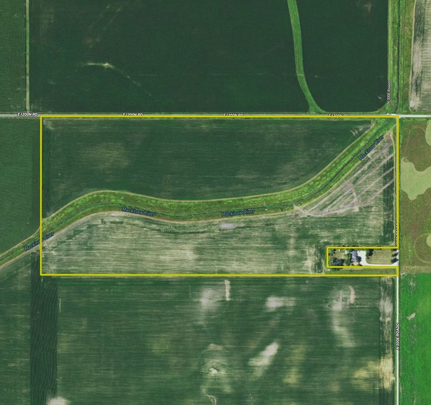
FORD CO, IL 69.23 +/- ACRES
AUCTION DETAILS PROPERTY DETAILS
• DATE/TIME: 11/23/21 AT 5:30 PM • TOTAL ACRES: 69.23+/- ACRES OFFERED
• AUCTION TYPE: LIVE AND ONLINE IN 1 TRACT
• AUCTION LOCATION: AMEERICAN LEGION • DETAILS: 60.72 ACRES TILLABLE AND
203 N SANGAMON AVR 6.49 ACRES IN CRP
GIBSON CITY, IL 60936 • SELLER: FORD/YENTES
RANCH & FARM AUCTIONS LLC
                             INTRODUCTION

                   FORD CO, IL 69.23 +/- ACRES

ENTIRE FARM DESCRIPTION

For the first time in over 60 years, the Yentes Family Farm, located SW of
Sibley, Illinois will be offered to the public thru a live and online auction. The
farm is made up of roughly 62.4+/- tillable acres with an average Soil PI of
134.2. There are some tile improvements on the farm. There are also 3 CRP
contracts, the first is a CP21 planting of 4.4 acres paying $998 annually
through 2022. The second, a CP33, 1.5 acres paying $342 through 2023. The
last planting is CP43, .59 acres paying $120 through 2030. The majority of the
farm’s soil types are Milford silty clay loam, Brenton silt loam, and Drummer
silty clay loam.

•   First time being offered to the public in a generation
•   Average PI 134.2
•   69.23 fertile acres
•   Great road frontage
•   Well maintained farm
RANCH & FARM AUCTIONS LLC
                                                                            FSA MAP

              United States
              Department of
              Agriculture       Ford County, Illinois

                                                                         33 25N 7E                                                                                           34 25N 7E

  E 1200N Rd

                 1
                 29.67
                 NHEL
                                                                                   T 8562
                                                                                                           CRP
                                                                                             HEL
                                            -
                                            &                                        3 4. 40
                                   3
                                5.3
                            4

                                                                                   5 31.05 NHEL
                                                                                                                                                            CRP
                                                                                                                                                       EL
                                                                                                                                                     NH
                                                                                                                                          0   .5 9                                  3 24N 7E
                                                                                                                                      6

                                                                              4 24N 7E
                                                                                                                                                          HEL     CRP
                                                                                                                                                 2 1. 49 N

                                                                                                                                                                        N 300E Rd

  ²
Common Land Unit                          CRP                           0       170       340                 680                                     2021 Program Year
       Non-Cropland                       Tract Boundary                                                                                                    Map Created April 29, 2021
                                                                                                                 Feet
       Cropland                           plss_a_il_WMAS

Wetland Determination Identifiers
                                                                                                                                                                  Farm 2938
 - Restricted Use
 &
 *
 #
     Limited Restrictions
                                                                                                                                                                  Tract 8562
 )
 "
     Exempt from Conservation                                  Tract Cropland Total: 67.20 acres
     Compliance Provisions
United States Department of Agriculture (USDA) Farm Service Agency (FSA) maps are for FSA Program administration only. This map does not represent a legal survey or reflect actual
ownership; rather it depicts the information provided directly from the producer and/or National Agricultural Imagery Program (NAIP) imagery. The producer accepts the data 'as is' and
assumes all risks associated with its use. USDA-FSA assumes no responsibility for actual or consequential damage incurred as a result of any user's reliance on this data outside FSA
Programs. Wetland identifiers do not represent the size, shape, or specific determination of the area. Refer to your original determination (CPA-026 and attached maps) for exact
boundaries and determinations or contact USDA Natural Resources Conservation Service (NRCS).
RANCH & FARM AUCTIONS LLC
TRACT 1 INFO
Aerial Map TRACT #: TRACT 1
DEEDED 69.23+/- TAXABLE ACRES
ACRES:
FSA FARMLAND 67.2 +/-
ACRES:
DCP CROPLAND 60.72 EFFECTIVE ACRES
ACRES:
SOIL TYPES: MILFORD SILTY CLAY LOAM,
BRENTON SILT LOAM, DRUMMER
SILTY CLAY LOAM, HARPSTER
CLAY LOAM
SOIL 134.2 PI
PI/NCCPI/CSR2:
BASE ACRES CORN BASE 29.2 ACRES/PLC
AND YIELD: YIELD 135, SOYBEAN BASE 29.2
ACRES/PLC YIELD 45
Map Center: 40.570696, -88.407575 0ft 635ft 1269ft
4-24N-7E TAXES: $2774.88
Ford County
Illinois
LEASE STATUS: OPEN TENANCY FOR 2022 CROP
9/27/2021
Field borders provided by Farm Service Agency as of 5/21/2008.
YEAR
Soils Map POSSESSION: IMMEDIATE POSSESSION SUBJECT
TO CURRENT TENANTS RIGHTS
FOR 2021
SURVEY NO SURVEY NEEDED
NEEDED?:
State:
County:
Illinois
Ford
BRIEF LEGAL: S4 T24N R7E FORD CO, IL
Location: 4-24N-7E
PIDS: 08-08-04-200-004
Township: Sullivant
Acres: 62.4
Date: 9/27/2021
LAT/LON: 40.5719, -88.4089
Soils data provided by USDA and NRCS.
Area Symbol: IL053, Soil Area Version: 16
Table: Optimum Crop Productivity Ratings for Illinois Soil by K.R. Olson and J.M. Lang, Office of Research, ACES, University of Illinois at
Champaign-Urbana. Version: 1/2/2012 Amended Table S2 B811
Crop yields and productivity indices for optimum management (B811) are maintained at the following NRES web site: http://soilproductivity.nres.illinois.edu/
** Indexes adjusted for slope and erosion according to Bulletin 811 Table S3
a UNF = unfavorable; FAV = favorable
c Soils in the northern region or in both regions were not rated for grain sorghum and are shown with a zero "0".
Soils data provided by USDA and NRCS. Soils data provided by University of Illinois at Champaign-Urbana.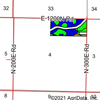
RANCH & FARM AUCTIONS LLC
                    CONTACT

                FULL DETAILS AT:
           RANCHANDFARMAUCTIONS.COM
            WHITETAILPROPERTIES.COM

                    BID ONLINE AT:
HTTPS://RANCHANDFARMAUCTIONS.COM/AUCTIONS/NEARLY-
     ALL-TILLABLE-FARM-WITH-INCOME-IN-FORD-CO-IL

              FOR MORE INFORMATION
               CALL TEXT OR EMAIL:

             YOUR LOCAL LAND SPECIALIST

             ADAM CRUMRIN, ILLINOIS LAND SPECIALIST
             M: (217) 276-2334
             ADAM.CRUMRIN@WHITETAILPROPERTIES.COM
You can also read