Purfleet Conservation Area - Character Appraisal March 2007 - Thurrock Council
←
→
Page content transcription
If your browser does not render page correctly, please read the page content below
Purfleet
Conservation
Area

Character Appraisal
March 2007
Index                                                                      Page

Introduction                                                                1

Planning Policy Framework                                                   2

Special interest of Purfleet                                                4

   1. Origins and historic development

   2. Character analysis

        - General character and settlement form of Purfleet

        - Building materials and details in Purfleet

Community Involvement                                                       8

Boundary changes                                                            8

Management considerations                                                   9

Appendices

      Appendix 1 - Thurrock Borough Local Plan 1997 –                       10
      Conservation area policies

      Appendix 2 - Listed buildings in Purfleet Conservation                11
      Area as shown in the 17th list of Buildings
      of Special Architectural or Historic Interest (as at January 2007)

                                www.thurrock.gov.uk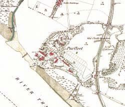
Introduction
    Purfleet Conservation Area was designated in 1985.

    The designation of a conservation area should not be seen as
    an end in itself. It is important that conservation areas are
    regularly reviewed and the preparation of a character
    appraisal is a part of this process. An appraisal should be
    regarded as an opportunity to re-assess a conservation area
    and to evaluate its special interest and significance. It is the
    defining of special interest that is the main purpose of the
    appraisal. The appraisal should also provide a basis for making
    sustainable decisions about the future of the conservation
    area through the development of management
    considerations.

    The core of the appraisal is the definition of the special
    interest of the Purfleet Conservation Area and this is intended
    to provide a vivid, succinct picture of how it is today together
    with an evaluation of its key characteristics.

    Reference is made to the relevant national and local planning
    policy framework. An outline is provided of the steps that
    have been taken to involve the local community and other
    interested parties in the preparation of the appraisal.

    Boundary changes are described and an indication of
    management considerations provided.

    It is emphasised that no appraisal can ever be fully
    comprehensive and the omission of any particular building,
    feature or space should not be taken to imply that it is of no
    interest.

1
           Purfleet Conservation Area - Character Appraisal
Planning Policy Framework
A conservation area is an ‘area of Special Architectural or
Historic Interest, the character or appearance of which it is
desirable to preserve or enhance’ (Planning (Listed Buildings
and Conservation Areas) Act 1990). Designation places certain
duties upon local planning authorities. They must review the
‘special interest’ of their areas from time to time and also
consider whether new conservation areas should be
designated
The Adopted Thurrock Borough Local Plan 1997 forms part of
the development plan for Thurrock and provides the basis for
decisions on land use planning. It contains policies regarding
the designation, review and enhancement of conservation
areas, together with guidance relating to the control of
development within them. These Local Plan policies are
outlined in Appendix 1
The Council is currently preparing its Local Development
Framework. This will be a range of documents containing
policies and proposals to guide the future development and
use of land in Thurrock up to 2021, including those relating to
conservation areas. It will form part of the statutory
development plan and will replace the Local Plan.
With regard to the control of development within
conservation areas the Town and Country Planning (General
Permitted Development) Order 1995 requires that planning
applications be made for certain types of development which
are elsewhere considered to be ‘permitted development’. This
includes various types of cladding; the insertion of dormer
windows into roof slopes; the erection of satellite dishes on
walls, roofs or chimneys fronting a highway; and the
installation of radio masts and antennae. The size of house
and industrial extensions that may be carried out in
conservation areas without a specific grant of planning
permission is also more restricted.
2
www.thurrock.gov.uk26
2
2
74 Health Centre
7 24
7
SM
76 5 83
26
Mardyke
34
1
22
6
2 84 Surgery
Sluice NTL 11 21
8
y
5
Y
3
8
r
15
11
32
El Sub Sta
WA
on
16
Purfleet Conservation Area Character Appraisal - Special Interest (not to scale). 38
40
s
44
N
Sloping mason
5
ma
8
ry 13.7m
9
12
g
IO
12 15
7
42
in
Shelter
50
UR
op
7
NT
11
Sl
7
9
31
CE
20 1
MA 12 RA
48
2
56
PI SA
17
RI
5
NE ER LA
14 CL DI
9 11 N
8
CO OS
E
58
12 UR
66
8 T DR
2
12 3 IV
4 E
1
13
16
13 9
2
E
12
8
13 1
IV
64
72
DR
LB Purfleet
AN
TC
Bs County Primary School
1
FT
7
74
78
IE
MP .75
17
76
19 32
de
CH
80
20
ra
33
PO
Playground
36
5 21
Pa
38
11 6 22 34
o n
17 12 7 23
33
35 1
is
24
13 24
Me
1
rr
2
35
18 6
an
Ga
3
6
25
88 86
4
84 82
BM 19.52m
12
Hi
26 36
gh
30
27 37 18.9m
32
28
Wa
32
te
38
r
29
98
21.0m
90
30 39 20.4m
28
29
31
BM 18.72m
25
Mean
25
53 NE 16.8m
27
COURT 40 LA BM 16.95m
CCLW
High
RIVER 24
96
104
41 54
42
3 CO NK
SL
MU
23
1 TA
24
55 4 ME
43 2 T
Water
44 56 CL
45
Mud OS
E El 20.7m
Hall Sub Sta
112 110
22
46
108 106
LBERRY
9
Sl 57
47 5 109 to 123 125 to 139 141 to 155
op 48
TANK LANE
in
g 49 Play 17
Centre
21
18.6m
20
ma 50 12 15
DRIVE
so 8
nr 51 16 13
y
Path
52 14
16
Woodlands 92
78
19
80
Pre School House 94 to 108
COURT
13
School
71 58
RIVER 59
15
94
93 72 60
20.1m
Mud
96 95 79 61 73
85 80 62
10
91 74
86 81 63
12
92 87 64
75
8
65
9
70
MUL
r
76 66 BER
67 RY
we k
C
DRI
To loc
77 68
VE
69
78 4 1
7
6
70
2
5
3
Y
41 Church Hollow
WA
43
N
39
IO
Church House Tank
UR
NT
47
C
CE
d
35
HO HU
Un
LL RC
OW H
33
Church Hollow
D
CENTUR
WAY
A
ION
RO
27
Church Bungalow
LL
El Sub Sta Church
226 to 236
Cottage
HI
NK
CH
TA
10 12 to 28
UR
8
C H
17
HO 2 220 to 214
9
LL
OW
El Sub Sta
409
1
D
M ES
OA
3
190 to 206
LI
1 188
LLR
E
184
403
TH
CASPIAN WAY
4
34
1
5
SL
TANK HI
389
Rose Cottage
Sh
7
Pa
3
in
th
34
38
9
gl
LO
e
17
8
The
RO
8
ON
A
Parsonage Harlow
16
ND D
7 St Stephen's
Vine Depot
1
Cottages Church
Me
HI 3
10
an
3
GH 37
Hi
ST
gh
RE 1
Wa
ET
357
4
te
r
Bu
n
18
3
War Memorial
NE
Di gal
g
p p ow
LA
in s
365
16
The
The El
Sub
CH
Royal Royal Sta 5
UR
Hotel 9 Ho
Hotel ll
CH
LB 1 ow
Co
363
tt
Sl
7 ag
op
es
10
in
1
g
12
5
ma
so
to
nr
13
y
0
13
4 13 1
12 3 15
13
ay to 2 6
ew 9 13
us 10 4
Ca to
13
6
13
8 7
10 to
14
to 2 143
93 145 144 Works
Shingle
F
146
R
HA
92
W
to
El Sub Sta MP 16
S
77
1
ON
Mud
Ri
IS
RR
ve 76 Bot
Shingle 6
HA
r to
any
Ter
61 rac
e
Co
Th
rn
Lo
El
wa
am
Sub Sta
ll
ng 60
Sl to
BM
Ho
es op
41 9.36m Depot
us
in Botany
e
g
Re
Ma
LO
so
ac
ND
h nr 40
y
ON
to
21
RO
AD
20
to
1
Mud
6.1m
WB
El Sub Sta Tanks
Tank El Sub Sta
Legend:
Significant open space Scheduled Ancient Monument Conservation area boundary
Listed Building Highways of historic significance
Significant physical/built form
n.b. detailed information regarding listed buildings or the scheduled ancient monuments should be verified separately
Reproduced from the Ordnance Survey mapping with the permission of HMSO,
© Crown Copyright. Thurrock Borough Council Licence number 100025457 (2006)Special Interest of Purfleet
1. Origins and historic development
There is significant evidence of early human activity in the
Purfleet area. Many worked flints and tools dating from
the Palaeolithic, Mesolithic and Neolithic periods have
been found. Pottery from between the Bronze Age and
Roman periods has also been discovered.
Chalk extraction took place in the vicinity of Purfleet from
the 16th century onwards and had a significant impact
upon the landscape. In the18th century the Whitbread
family, owners of the chalk quarries, developed a planned
village at Purfleet. The Whitbread Estate included Church
House, Church Bungalow and Church Cottage all built
within a previously extracted area (Church Hollow). The
existing terraces Hollow Cottages and Botany Terrace 19th century map of Purfleet
were also originally part of the Whitbread Estate.
Whitbread House was demolished to make way for the A significant building in Purfleet is the Royal Hotel, built
existing St Stephen’s church and The Parsonage. in the 18th century. This was originally a house and
subsequently became ‘The Ship’, ‘The Bricklayers Arms’
and in the 19th century the ‘Purfleet Hotel’ when
Purfleet became a fashionable visitor attraction. It took
on the name Royal Hotel allegedly following a visit from
the Prince of Wales.
Chapman & Andre map (1777)
Purfleet gunpowder magazines
An explosion at the Woolwich Garrison resulted in the
construction of a magazine at Purfleet in the 18th The historic military garrison use ceased during the 1970’s
century. Purfleet became the receiving house where all and the majority of the buildings were demolished. They
gunpowder used by the government was landed by were replaced by the substantial new residential
barge, examined, tested and, if approved, stored. development of the Garrison Estate.
Five large gunpowder magazines were built close to the Upon the cessation of chalk extraction, the quarries
Thames within approximately 25 acres of ground adjacent to Purfleet (The Dipping) were used as an oil
occupied by the government, which was moated round storage depot. Towards the end of the 20th century the
and walled. One of the magazines remains together with storage use ceased and the tanks were eventually
evidence of the inner and outer security walls. A clock demolished. The area is presently being developed for
tower at one of the four entrances and a proof house residential purposes. A variety of industrial and
(barrel store) also remain. commercial uses established themselves on the banks of
the Thames close to the village centre. The uses also
ceased operating towards the end of the 20th century
and the sites were redeveloped for residential purposes.
4
www.thurrock.gov.uk2. Character analysis Initially it is wide enough to be an access road and is
partially framed to the north by the former outer garrison
General character and settlement form of wall. Tank Lane gives access to the early 20th century
Purfleet Edwardian arts and crafts educational buildings to the
north. This area is crowned by mature trees, which are on
The riverside green the crest of the hill.
The riverside green is a substantial riverfront open space
which has wide views across the River Thames to Kent
and upriver to Canary Wharf. It rises up the escarpment
slope to the ridge to the north. There are avenues of
mature trees, which are important to the river front to
the west of the riverside green and further up the hill
towards the hilltop. There is a 20th century community
hall to the west of the riverside green and it is crossed by
the primary route of Tank Hill Road and also Centurion
Way providing access to the housing to the west.
Royal Hotel
ii. to the west
The garrison inner wall rises up the slope to the entrance
gateway and Clock Tower. The modern access road,
Centurion Way, has been cut into the slope and has steep
banks. There is some single storey modern housing south
of the gateway and fronted by a mature avenue of trees.
To the north, the modern housing follows the line of the
edge of the former garrison ground and the line of the
outer wall. Towards the riverside walk is a copse of
mature trees on top of an earth mound.
Tank Lane
Tank Lane is wide enough to be an access track to a few
20th century houses on the north side and then narrows
as a footpath along the higher ground above the quarry
cliff face, to the east. The high chalk cliff face on the
south side of the lane is a visually strong part of the
character of Purfleet Conservation Area and has historical
Riverside green and view upriver from Purfleet importance with regard to quarrying activities.
The riverside green is framed by -
i. to the east
The riverside walkway, which itself is framed by the 18th
century three-storey Royal Hotel which is a listed building
(LB) and its plain single and three storey 20th century
attachments. The recent planting of this area has failed.
There is a flint faced and brick capped wall which frames
the east side of the green. It is interrupted for the entry
to the High Street. Mature trees to the rear rise above the
edge wall. The ancient lane, Tank Lane, forks to the east,
and proceeds on the ridge of the former chalk quarry.
Chalk cliff face under Tank Lane
5
Purfleet Conservation Area - Character AppraisalThe Purfleet Garrison High Street
The government moved the Royal magazine to Purfleet in The High Street is framed by -
the 18th century. The No. 5 Magazine (LB), the Proof
House (Barrel Store) and the Clock Tower (LB) are i. north side
scheduled ancient monuments. Along with the wall, they
are the primary residual structures of the Purfleet On the northwest corner, set behind a small garden, is
Garrison. The magazines were located on the level and at the 19th century arts and crafts style Rose Cottage.
right angles to the wharf. The Proof House (Barrel Store)
is located to the rear and is set into the escarpment bank,
within a strong group of mature trees. The buildings are
constructed of 18th century dark red brick and are of
government engineering quality to withstand and contain
explosion. The Clock Tower surmounts the gateway in the
wall and is an 18th century structure constructed in stock
brick. The doors are in cast iron frames.
Rose Cottage
The Whitbread family developed a relatively small
industrial estate here in the 19th century. To the east and
set on the edge of the pavement, is the 19th century
terrace nos. 1 to 7 High Street. Beyond are the open
green and the war memorial within the churchyard for
the St. Stephen’s church. Behind this is a 20th century
housing estate tucked within the mature trees and to the
north of this, within Church Hollow, are the late 18th
century stock brick Church House (former chapel) (LB),
Church Cottage (former schoolmaster’s house) (LB) and
Church Bungalow (former schoolhouse) (LB), which are
no longer occupied and have become derelict. They sit in
a hollow with the quarry cliff rising to the northwest.
1 to 7 High Street
No.5 Magazine, Proof House (Barrel Store) and Clock
Tower
6
www.thurrock.gov.ukTo the east, and set back from the High Street, Building materials and details in Purfleet
surrounded by an important mature tree group and
accessed by a descending narrow track are the 19th In Purfleet buildings were largely constructed from the
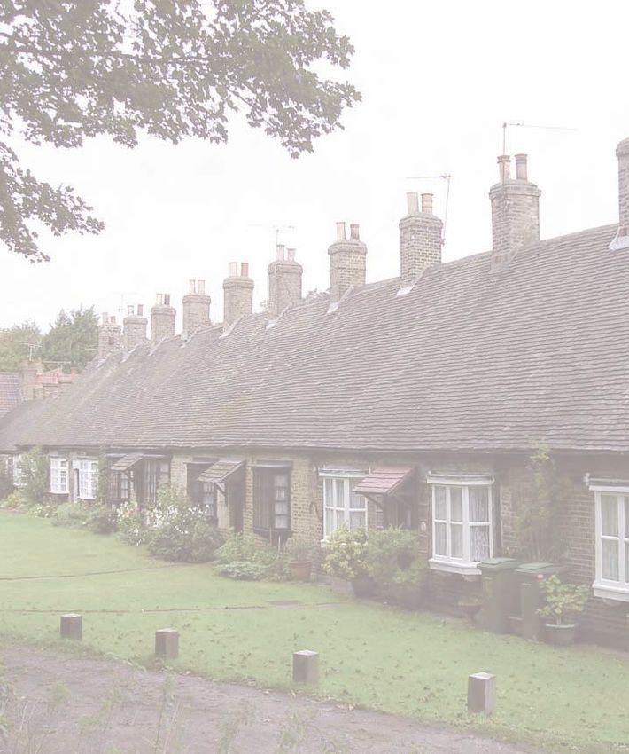
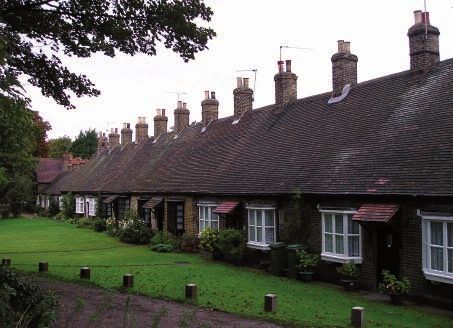
century almshouse character Hollow Cottages (LB) 18th century. Essentially these are all brick walled
fronting onto a communal green. buildings.
The present external appearance of many of these earlier
original buildings owes their external surface character
from the later more prosperous 18th and 19th centuries.
The basic building forms with later detail changes give
Purfleet Conservation Area its varied sense of historic
detail, with the exception of the majority of the 20th
century buildings and additions. Although the use of
locally sourced materials and skills unites the character of
the historic vernacular structures to give them their
special interest, the government buildings used the best
materials and sourced them nationally.
In addition to the historic building forms, walls, roofs,
doors and windows, the materials and details also have
special interest.
Hollow Cottages
A little further to the east and set at the edge of the
pavement to London Road is the 19th century Botany Brick
Terrace.
Hand made bricks come into use as external walling in
the 18th century (red brick) and in the 19th century
(yellow stock or grey gault brick).
Until the later 19th century lime mortar was used. In the
20th century, re-pointing and repair often uses
detrimental cement based mortar.
In the late 19th and early 20th century cement and
machine made bricks became available as a walling
material.
Although previously lime render and weatherboard had
been used to reduce the penetration of damp on
traditional buildings, with the availability of expanded
metal lath some buildings were encased in cement
Botany Terrace render.
ii. south side Industrially produced materials such as asbestos and
concrete tiles also came into use in the 20th century.
Whilst the north side of the High Street is rich in the Due to their interlocking, lower pitched roofs than before
remaining spaces and buildings of the Whitbread Estate, were constructed.
the south side is now enclosed by 21st century riverside
linked development. To the rear of the Royal Hotel, the All of these forms contribute to the interest and character
garden is not screened and although the mature trees are of Purfleet Conservation Area although not all are
retained, a lower car park has been introduced. externally visible.
7
Purfleet Conservation Area - Character AppraisalCommunity involvement Boundary changes
Involving the local community and raising public An important aspect of the appraisal process is the
awareness has been an integral part of the process of consideration of where the boundary of the Conservation
preparing the character appraisal. Area should be drawn. The appropriateness of current
boundaries should be regularly reassessed, perhaps on a
This took the form of sending consultation letters to all five-year cycle (Guidance on conservation area appraisals
residents and occupants in the Conservation Area – English Heritage 2006).
requesting views on the following-
Two boundary changes have been made to Purfleet
• What features are important to Purfleet Conservation Area -
Conservation Area and make it special
• The Proof House (Barrel Store) is a scheduled ancient
• What adds to the character monument. This building and the surrounding treed
slope have been included within the Conservation
• What takes away from the character Area. There are three buildings of the 18th century
Purfleet Garrison complex remaining, all of which are
Included with the consultation letter was a questionnaire scheduled ancient monuments. However, only the
together with a plan of the Conservation Area and a No.5 Magazine and the Clock Tower were within the
summary of the considered character and possible issues. original Conservation Area. It is consistent to include
all of the components of special architectural and
In addition, the entire public consultation process took historic interest in the Conservation Area.
place online on the Council’s website. Notice of the
public exhibitions was given in the local press. • On the top of the north cliff of The Dipping, Tank
Lane is within the original Conservation Area. The
Purfleet Community Forum was consulted, as were local quarry face is an important visual and historic
ward members, the MP and other interested parties. feature. The most visible part, the cliff face itself,
has been included within the Conservation Area. In
An exhibition with historic maps, photographs and addition, the Conservation Area has been extended
documents was held on 4th and 5th October 2006 at to include part of Tank Lane (to the eastern end of
Purfleet Heritage Centre, No 5 Magazine, Purfleet where the adjacent housing to the north)
Officers were available to talk through issues and answer
questions.
The consultation responses affirmed the following issues:
• The importance of the designated Conservation
Area
• The possible expansion to include other areas of
special interest
• Involvement of the public in the process of character
appraisals
• Involvement of the public in the production of
management proposals
• The preservation and management of the special
issues
• Any new proposal should respect and not detract
from the existing character
8
www.thurrock.gov.ukManagement considerations
Conservation Areas are living environments, which
are inevitably subject to change and evolution. The
original character of some buildings in the Purfleet
Conservation Area has already been altered, through
for example replacement windows and concrete roof
tiles.
It is important to try and prevent the erosion of the
essential character of the Conservation Area as a
result of inappropriate changes. Exposed and
prominent boundary treatments in the Conservation
Area are important and their alteration has the
potential to be a problem.
The Council will consider the production of design
guidance with regard to matters of the nature
outlined to assist residents and landowners in their
choices.
Once a conservation area is designated, additional
planning controls can be introduced by limiting
permitted development rights through the issue of
an Article 4(2) direction under the Town and Country
Planning (General Permitted Development) Order
1995.
Planning permission would then be required for the
works that are specified. There is no intention at this
stage to consider use of an Article 4 direction.
Nevertheless the Council reserves the right to
consider use of a direction in the future if it is
deemed necessary and appropriate to control serious
loss of character.
In the event that such a decision is taken, there
would be a formal process of notification and
opportunity for those affected to support or object
to the proposal.
It is intended to produce Management Proposals for
Purfleet Conservation Area. The Management
Proposals will outline general and specific issues
relevant to the Conservation Area and may include
recommendations for action.
9
Purfleet Conservation Area - Character AppraisalAppendix 1 – Thurrock Borough Local Plan 1997 – Conservation Area policies
BE22 – Conservation Areas – Designation, Review BE-23A-Demolition in Conservation Areas
and Enhancement
‘The Council will not grant consent for the total or
‘The Council will regularly review conservation area substantial demolition of a building in a conservation area
boundaries, amend them when necessary and examine unless it can be shown to their satisfaction that the
the need to designate new conservation areas using the building is wholly beyond repair; incapable of reasonably
following broad criteria to assess the special interest of beneficial use; or where its removal would enhance the
areas: character or appearance of the area.
(i) The origins and development of the topography of If necessary, the Council will impose a condition on the
the area; grant of any consent providing that any development
shall not take place before a contract for carrying out the
(ii) Archaeological significance and potential; works of redevelopment on the site has been granted for
the development for which the contract provides.’
(iii) Prevalent building materials, character and hierarchy
of spaces; BE24-Article Four Directions in Conservation Areas
(iv) The quality and relationship of buildings in the area ‘In exceptional circumstances, including where there are
including the contribution of unlisted buildings; real and specific threats to the character of the
conservation area, and subject to approval by the
(v) The contribution made by trees and other green Secretary of State, the Council will make direction under
features. article 4 of the General Development Order to restrict
permitted development rights in conservation areas.’
Using the above criteria, the Council will also formulate
and publish proposals for the preservation and
enhancement of conservation areas’.
BE23 – Development affecting Conservation Areas
‘Development proposals within, adjacent to, or affecting
the Borough’s conservation areas will be expected to
preserve and enhance their character or appearance. The
Council will not permit any development that would be in
conflict with this objective.
In this regard, special attention will be paid to the
following:
(i) The retention and protection of all buildings,
whether listed or not, trees and any other features
which are important to the character or appearance
of that area;
(ii) The position of new buildings, which should
enhance the character and appearance of the area
and be in scale and harmony with the adjoining
buildings and the area as a whole;
(iii) The use of materials, which should be appropriate
to the area and sympathetic to adjoining buildings.
The desirability of preserving or enhancing the area will
also be taken into consideration by the Council in the
handling of development proposals which are outside the
area but would affect its setting, or views into or out of
the area.’
10
www.thurrock.gov.ukAppendix 2-Listed Buildings in the Purfleet Conservation Area as shown in
the 17th list of Buildings of Special Architectural or Historic Interest (as at
January 2007)
CENTURION WAY CHURCH HOLLOW
No 5 (Government Powder Magazine) Church Cottage
Grade II Grade II GV
Removed to Purfleet from Greenwich from 1760 Former schoolmaster's house built in 1790. In painted
onwards. Circa 1800, powder magazine in grey stock brick with grey slate roof. One storey and attics.
brick, with grey slate roof. Stone capped gables. Parapetted verges. Two window range C19 casements.
Central louvre in semi-circular recess. Dentilled eaves Two C19 flat roofed dormers. Central entrance door, and
course. Twelve slit windows in flank walls. Flat topped end wall chimney stacks.
porches at end and sides with segmental headed arches
to doors.
CHURCH HOLLOW
Hollow Cottages
CENTURION WAY
Clock Tower Grade II
Grade II Built 1790, altered in mid C19 and C20. Terrace of 12
cottages, reduced to 6 in mid C19, by making one unit
Circa 1800. Clock Tower, in yellow stock brick. Lower out of two. Grey stock brick and red plain tile roof. Single
stage with round headed arch, in each face, stone band storey. Twelve window range, C19 oriel bays, with glazing
over with square panelled brick stage above. Roof bars, and C20 metal casements. Grey brick chimney
surmounted by square pedimented stage, with circular stacks. Extended in mid C19, by 2 similar units, with
clock faces. lower pitch roof clad in modern plain tiles. Four window
Square bell turret over with square dome and range, oriel bays. C20 gabled 2 storey extension at west
weathervane. end.
CHURCH HOLLOW LONDON ROAD
Church House Royal Hotel
Grade II GV Grade II
Built 1791 as a chapel, converted into a dwelling in C20. Early C19 house in rendered brick with grey slate roof.
Painted brick with grey slate roof. Two storeys Three Three storeys.
window range, modern casements. Five window range, C19 double hung vertical sliding
Windows are set in recessed panels, with semi-circular sashes, in plain reveals.
arched heads. String course and dentilled eaves course. Plain parapet, central 3 bays raised up, with horizontal
capping. Two storey balcony, part infilled, with slender
stucco piers to ground floor, cast iron supporting posts to
CHURCH HOLLOW first floor. Tented lead roof with valance. Extensive
Church Bungalow modern extension on west and north sides.
Grade II GV
Former Schoolhouse, built in 1790. In grey stock brick,
part painted, with grey slate hipped roof. Single storey.
Three window range, casement, with semi-circular heads,
set in recessed full height panels, with semi-circular
heads, and panels of knapped flint beneath cills.
11
Purfleet Conservation Area - Character Appraisal12 www.thurrock.gov.uk
TCPA/9/07

www.thurrock.gov.uk
You can also read