Proposed Variation No. 1 - Zoning Objective Amendment on Lands at Grangecastle West - South Dublin County Council
←
→
Page content transcription
If your browser does not render page correctly, please read the page content below
A VISION FOR SOUTH DUBLIN’S FUTURE

Proposed
Variation No. 1

Zoning Objective Amendment
on Lands at Grangecastle West

Appropriate Assessment (AA)
Screening Report and Determination Report

                                        February 2018
Appropriate Assessment (AA) Screening Determination in accordance with the EU’s Habitats
Directive Article 6(3) and the Section 177U of the Planning and Development Act 2000 (as amended)
by South Dublin County Council as Competent Authority.

Natura 2000 sites are defined under the Habitats Directive (Article 3) as a European ecological network
of special areas of conservation composed of sites hosting the natural habitat types listed in Annex I
and habitats of the species listed in Annex II. The aim of the network is to aid the long-term survival of
Europe's most valuable and threatened species and habitats. In Ireland these sites are designed as
European sites - defined under the Planning Acts and/or Birds and Habitats Regulations as (a) a
candidate site of Community importance, (b) a site of Community importance, (c) a candidate special
area of conservation, (d) a special area of conservation, (e) a candidate special protection area, or (f)
a special protection area. They are commonly referred to in Ireland as candidate Special Areas of
Conservation (cSACs) and Special Protection Areas (SPAs).

                                                              Land Use Planning and Transportation Department

                                                                                    South Dublin County Council

                                                                                                             2018
Section 1 Introduction An Appropriate Assessment (AA) Screening Determination has been made by South Dublin County Council regarding the Proposed Variation No.1 of the South Dublin County Council Development Plan 2016-2022. The proposed variation is seeking to make additions to the South Dublin County Development Plan 2016-2022, a plan which through a series of policies and objectives sets out the vision for the future growth and development of South Dublin up to 2025. Proposed land use plans must undergo a formal “test” or “screening” to ascertain whether they are likely to result in any significant adverse effects on specific sites designated for their nature conservation importance. These sites are those designated under the European Commission’s Natura 2000 network of sites (hereafter “European sites”). These sites are designated on the basis of the presence of certain habitats and species that are deemed to be of international importance. The Irish Government and local planning authorities have a legal obligation to protect these sites. The Habitats and Birds Directives are the framework for the designation of these sites. The Habitats Directive (92/43/EEC) requires the “screening’” of plans and projects under Article 6(3). If the screening process results in a judgement that likely significant effects may occur or cannot be ruled out, then a more detailed appropriate assessment (AA) is required. This report constitutes the Appropriate Assessment Screening Determination Report of Proposed Variation No. 2 to the South Dublin County Development Plan 2016-2022 and follows on from the preparation of an Appropriate Assessment Screening Report (December 2017). Section 1 Introduction Section 2 Determination Having regard to the content of Proposed Variation No. 1 and consideration of the potential for significant impacts arising from its implementation which may have the potential to adversely affect any Natura 2000 site; with regard to their qualifying interests and conservation objectives, it was determined as part of the Screening for Appropriate Assessment that it is possible to rule out likely significant effects on all European sites. This decision has been informed following an examination, analysis and evaluation of the relevant
information, including in particular, the nature of the proposed variation and its potential
relationship with European sites, as well as considering other plans and projects, and applying the
precautionary principle, it is possible to rule out likely significant effects on all European sites
assessed.

The principle trigger for a Natura Impact Report would be if the proposed variation was likely to have
significant effects on a NATURA 2000 site. The proposed variation is part of the review of the zoning
of lands required under Policy ET3 SLO1 of the South Dublin County Development Plan which seeks
to conduct a review of the zoning of lands to the south of the Grand Canal with a view to preparing
a long term plan for the expansion of the Grange Castle Economic and Enterprise Zone to the area.
The proposed variation also seeks to amend the location of the long term road objective in the area.

The proposed variation seeks to change the zoning of approximately 193 hectares of existing land
from Objective RU, Rural Amenity area to Objective EE, Enterprise and Employment area. No
negative impacts are predicted from the implementation of this proposed variation. The polices and
provisions of the South Dublin County Development Plan 2016-2022 to which the proposed variation
will form part have been devised to anticipate and avoid the need for development that would be
likely to significantly and adversely affect the integrity of any Natura 2000 sites or areas of high
ecological value/interest.

A Strategic Environmental Assessment (SEA) Environmental Report and an Appropriate Assessment
(AA) Screening Report (in accordance with the Habitats Directive) were completed during the
drafting of the South Dublin County Development Plan 2016-2022 which examined the cumulative
impacts of the plan’s policies and objectives on the environment, including Natura 2000 sites.
Mitigation measures were proposed and incorporated into the 2016-2022 Development Plan to
ensure that no negative impacts would arise from its implementation.

Therefore, in accordance with the Methodological Guidance on the provision of Article 6(3) and (4)
of the Habitats Directive 92/43/EEC, it is concluded that the proposed variation, does not require
any further assessment (Stage 2) to demonstrate compliance with the Directive.

Taking the above on board, along with the conclusions of the Appropriate Assessment Screening
Report (December 2017), it is determined that further stages of Appropriate Assessment are not
required. The proposed variation has been prepared to ensure that any development (either
individually or in combination with other plans or projects) shall not give rise to significant adverse
impacts on the integrity or conservation objectives of any Natura 2000 sites.

Section 3 Conclusion

Having regard to Article 6(3) of the Habitats Directive and Part XAB of the Planning and Development
Acts 2000 (as amended), the guidance contained in the Department of Housing Planning, Community
and Local Governments “Appropriate Assessment of Plans and Projects in Ireland Guidance for
Planning Authorities” (2010) following an examination, analysis and evaluation of the objective
information provided in the “Proposed Variation No.1 to South Dublin County Development Plan
2016-2022 AA Screening Report” prepared by Doherty Environmental Consultants, South Dublin
County Council, as the Competent Authority determines that the proposed variation, individually
and in combination with other plans and projects, does not require an AA as it has been concluded
that it is possible to rule out likely significant effects on all European sites.
A VISION FOR SOUTH DUBLIN’S FUTURE

Proposed
Variation No. 1

Zoning Objective Amendment
on Lands at Grangecastle West

Appropriate Assessment Screening Report

                                        February 2018
Screening Statement for Appropriate Assessment
Variation No. 1
South Dublin County Development Plan 2016 - 2022
Document Stage Document Version Prepared by
Draft 1 Pat Doherty MSc, MCIEEM
Checked
NC, South Dublin County
Council
This report has been prepared by Doherty
Environmental Consultants Ltd. with all
reasonable skill, care and diligence.
Information report herein is based on the
interpretation of data collected and has been
accepted in good faith as being accurate
and valid.
This report is prepared for Clifton Scannell
Emerson Associates Consulting Engineers
on behalf South Dublin County Council and
we accept no responsibility to third parties to
whom this report, or any part thereof, is
made known. Any such party relies on the
report at their own risk.Table of Contents
1.0 INTRODUCTION 1
1.1 STAGE 1 SCREENING METHOD 1
2.0 PROJECT DESCRIPTION 3
2.1 ENVIRONMENTAL PROTECTION MEASURES OF THE PROPOSED VARIATION 4
2.1.1 SDCC CDP 2016- 2022 ENVIRONMENTAL PROTECTION MEASURES 5
2.1.2 SEA ER ENVIRONMENTAL PROTECTION MEASURES 10
2.1.3 ENVIRONMENTAL CONSTRUCTION & MANAGEMENT PLAN 15
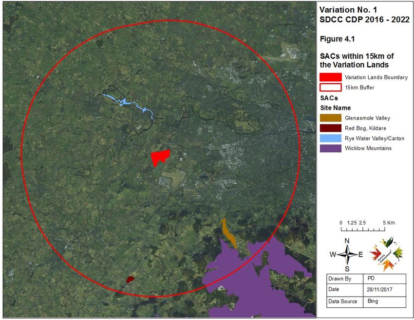
3.0 DESCRIPTION OF PROPOSED VARIATION LANDS 22
3.1 NATIONAL DESIGNATIONS ADJACENT TO THE PROPOSED VARIATION LANDS 22
3.1.1 OVERVIEW OF THE GRAND CANAL PNHA ADJACENT TO THE PROPOSED VARIATION LANDS
23
3.1.2 OVERVIEW OF THE LIFFEY VALLEY PNHA DOWNSTREAM FROM THE PROPOSED VARIATION
LANDS 27
3.2 HABITATS OCCURRING WITHIN THE PROPOSED VARIATION LANDS 27
3.3 FAUNA 30
4.0 EUROPEAN SITES OCCURRING WITHIN THE ZONE OF INFLUENCE OF THE PROPOSED
VARIATION 32
5.0 EUROPEAN SITES CONSERVATION OBJECTIVES 46
5.1 QUALIFYING FEATURES OF INTEREST/SPECIAL CONSERVATION INTERESTS OCCURRING
WITHIN THE SPHERE OF INFLUENCE OF THE PROJECT 48
6.0 DESCRIPTION OF ELEMENT OF THE PLAN THAT COULD RESULT IN LIKELY SIGNIFICANT
EFFECTS TO QUALIFYING INTERESTS 61
6.1 IN-COMBINATION EFFECTS 61
7.0 ASSESSMENT OF LIKELY SIGNIFICANT EFFECTS 62
REFERENCES 67Client: CSEA Consulting Engineers Date: Dec 2017
Project Title: Variation No. 1 SDCC CDP 2016 - 2022
Document Title: AA Screening Report
1.0 INTRODUCTION
South Dublin County Council intends to initiate the procedures for making a
Variation to the County Development Plan under Section 13 of the Planning
and Development Act 2000 (as amended). The proposed variation provides
for the following:
“ To ensure the sustainable and orderly development of Grangecastle, this
Council proposes to initiate a variation to the South Dublin County
Development Plan 2016-2022 to change the zoning of 193 hectares of land at
Grangecastle from Objective RU: To Protect and Improve Rural Amenity to
Objective EE: To provide for Enterprise and Employment.”
Doherty Environmental Consultants Ltd. have been commissioned by Clifton
Scannell Emerson Ltd. on behalf of South Dublin County Council to undertake
a Stage 1 Screening for Appropriate Assessment of the proposed variation.
This Screening for Appropriate Assessment forms Stage 1 of the Habitats
Directive Assessment process and is being undertaken in order to comply with
the requirements of the Habitats Directive Article 6(3). The function of this
Screening Exercise is to identify the potential for the project to result in likely
significant effects to European Sites and to provide information so that the
competent authority can determine whether a Stage 2 Appropriate Assessment
is required for the project.
1.1 STAGE 1 SCREENING METHOD
The function of the Screening exercise is to identify whether or not the proposal
will have the potential to result in likely significant effect on European Sites. In
this context “likely” refers to the presence of doubt with regard to the absence
of significant effects (ECJ case C-127/02) and “significant” means not trivial or
inconsequential but an effect that has the potential to undermine the site’s
conservation objectives (English Nature, 1999; ECJ case C-127/02 &). In other
words, any effect that compromises the conservation status of a European
Doherty Environmental 1 06/02/2018Client: CSEA Consulting Engineers Date: Dec 2017
Project Title: Variation No. 1 SDCC CDP 2016 - 2022
Document Title: Screening Statement
Sites and interferes with achieving its conservation objectives would constitute
a significant effect.
The nature of the likely interactions between the project and the conservation
status of European Sites will depend upon the sensitivity of these sites and
their reasons for designation to potential impacts arising from the project; the
current conservation status of the features for which European Sites have been
designated; and any likely changes to key environmental indicators (e.g.
habitat structure; vegetation community) that underpin the conservation status
of European Sites, in combination with other plans and projects.
This Screening exercise has been undertaken with reference to respective
National and European guidance documents: Appropriate Assessment of
Plans and Projects in Ireland: Guidance for Planning Authorities (DEHLG 2010)
and Assessment of Plans and Projects Significantly Affecting Natura 2000 sites
– Methodological Guidance of the Provisions of Article 6(3) and (4) of the
Habitats directive 92/43/EEC and recent European and National case law (ECJ
C-258/11 & High Court case ref 2014-320-JR). The following guidance
documents were also of relevance during this Screening Assessment:
A guide for competent authorities. Environment and Heritage Service,
Sept 2002. Appropriate Assessment of Plans and Projects in Ireland –
Guidance for Planning Authorities (2010). DEHLG.
Assessment of Plans and Projects Significantly Affecting Natura 2000
Sites – Methodological Guidance of the Provisions of Article 6(3) and (4)
of the Habitats Directive 92/42/EED. European Commission (2001).
Managing Natura 2000 Sites – The provisions of Article 6 of the Habitats
directive 92/43/EEC. European commission (2000). (To be referred to as
MN 2000).
Guidance on Article 6(4) of the Habitats Directive 92/43/EEC –
Clarification of the Concepts of: Alternative Solutions, Imperative reasons
Doherty Environmental 2Client: CSEA Consulting Engineers Date: Dec 2017
Project Title: Variation No. 1 SDCC CDP 2016 - 2022
Document Title: Screening Statement
of Overriding Public Interest, Compensatory Measures, Overall
coherence, Opinion of the Commission. European Commission (2007).
The EC (2001) guidelines outline the stages involved in undertaking a
Screening exercise of a project that has the potential to have likely significant
effects on European Sites. The methodology adopted for this Screening
exercise is informed by these guidelines and was undertaken in the following
stages:
1. Describe the project and determine whether it is necessary for the conservation
management of European Sites;
2. Identify European Sites that could be influenced by the project;
3. Where European Sites are identified as occurring within the sphere of influence
of the project identify potential effects arising from the project and screen the
potential for such effects to negatively affect European Sites identified under
Point 2 above; and
4. Identify other plans or projects that, in combination with the project, have the
potential to affect European Sites.
2.0 PROJECT DESCRIPTION
It is proposed to extend Grange Castle Business Park by rezoning an area of
193.47 hectares west of the existing Business Park which is operated by South
Dublin County Council in partnership with the Industrial Development Authority
(IDA) (see Figure 2.1 for the location of the proposed Variation Lands). This
proposed rezoning, will form a proposed variation to the existing South Dublin
County Development Plan 2016-2022 (SDCDP). This plan came into effect in
June 2016 and established the framework for the development over a six year
period for the county. The SDCDP was subject to Strategic Environmental
Assessment and Habitats Directive Assessment. Within the hierarchy of
Doherty Environmental 3Client: CSEA Consulting Engineers Date: Dec 2017
Project Title: Variation No. 1 SDCC CDP 2016 - 2022
Document Title: Screening Statement
landuse plans, the proposed variation should be compliant with the policies and
objectives of the SDCDP, as well as national and regional plans and guidelines.
The purpose of this proposed rezoning is to facilitate the extension of the
existing Grange Castle Business Park and to increase the landuse zoning
designation for this area. It is envisaged that a masterplan will be prepared
that will provide more detail on the layout etc of the lands but the initial, first
step is to propose the landuse change zoning from RU: To Protect and
Improve Rural Amenity to EE: To provide for Enterprise and Employment.
A specific objective is also included in the South Dublin County Development
Plan 2016-2022 for the area proposed for rezoning as follows:
ET3 SLO 1:
To conduct a review of the zoning of lands south of the Grand Canal and west
and north of the R120, including lands adjoining Peamount Healthcare, with a
view to preparing a long term plan for the expansion of the Grange Castle
Economic and Enterprise Zone to this area, to accommodate strategic
investment in the future, while also seeking to provide public open space along
the Canal, including a natural heritage area in the vicinity of the historic canal
quarries at Gollierstown.
2.1 ENVIRONMENTAL PROTECTION MEASURES OF THE PROPOSED
VARIATION
Existing environmental protection measures are set out in the South Dublin
County Council CDP 2016 – 2022 and have also be detailed in the SEA ER of
the proposed Variation.
Doherty Environmental 4Client: CSEA Consulting Engineers Date: Dec 2017
Project Title: Variation No. 1 SDCC CDP 2016 - 2022
Document Title: Screening Statement
2.1.1 SDCC CDP 2016- 2022 Environmental Protection Measures
The existing environmental protection measures of the South Dublin County
Council CDP that will afford protection to European Sites occurring in the wider
surrounding area of the proposed Variation Lands are outlined in Table 2.1
below.
CDP Text
Policy/Objective
Heritage, It is the policy of the Council to support the conservation
conservation and improvement of Natura 2000 Sites and to protect the
and landscapes Natura 2000 network from any plans and projects that are
(HCL) policy 12 likely to have a significant effect on the coherence or
natura 2000 integrity of a Natura 2000 Site
sites
Heritage, Natural Heritage Areas It is the policy of the Council to
conservation protect the ecological, visual, recreational, environmental
and landscapes and amenity value of the County’s proposed Natural
(HCL) policy 13 Heritage Areas and associated habitats.
Hcl13 objective To ensure that any proposal for development within or
1: adjacent to a proposed Natural Heritage Area (pNHA) is
designed and sited to minimise its impact on the
biodiversity, ecological, geological and landscape value
Doherty Environmental 5Client: CSEA Consulting Engineers Date: Dec 2017
Project Title: Variation No. 1 SDCC CDP 2016 - 2022
Document Title: Screening Statement
of the pNHA particularly plant and animal species listed
under the Wildlife Acts and the Habitats and Birds
Directive including their habitats.
HCL13 objective To restrict development within a proposed Natural
2: Heritage Area to development that is directly related to
the area’s amenity potential subject to the protection and
enhancement of natural heritage and visual amenities
including biodiversity and landscapes
Heritage, Non-Designated Areas It is the policy of the Council to
conservation protect and promote the conservation of biodiversity
and landscapes outside of designated areas and to ensure that species
(HCL) policy 15 and habitats that are protected under the Wildlife Acts
1976 and 2000, the Birds Directive 1979 and the Habitats
Directive 1992 are adequately protected
HCL15 objective To ensure that development does not have a significant
1 adverse impact on rare and threatened species, including
those protected under the Wildlife Acts 1976 and 2000,
the Birds Directive 1979 and the Habitats Directive 1992.
HCL15 objective To ensure that, where evidence of species that are
2: protected under the Wildlife Acts 1976 and 2000, the
Birds Directive 1979 and the Habitats Directive 1992
exists, appropriate avoidance and mitigation measures
are incorporated into development proposals as part of
any ecological impact assessment.
Doherty Environmental 6Client: CSEA Consulting Engineers Date: Dec 2017
Project Title: Variation No. 1 SDCC CDP 2016 - 2022
Document Title: Screening Statement
HCL15 objective To protect existing trees, hedgerows, and woodlands
3 which are of amenity or biodiversity value and/ or
contribute to landscape character and ensure that proper
provision is made for their protection and management in
accordance with Living with Trees: South Dublin County
Council’s Tree Management Policy 2015-2020.
Infrastructure & It is the policy of the Council to work in conjunction with
environmental Irish Water to protect existing water and drainage
quality (IE) infrastructure and to promote investment in the water and
policy 1 water & drainage network to support environmental protection
and facilitate the sustainable growth of the County.
Wastewater
IE1 objective 1 To work in conjunction with Irish Water to protect, manage
and optimise water supply and foul drainage networks in
the County.
IE1 objective 2: To work in conjunction with Irish Water to facilitate the
timely delivery of ongoing upgrades and the expansion of
water supply and wastewater services to meet the future
needs of the County and the Region
Water
Resources
Doherty Environmental 7Client: CSEA Consulting Engineers Date: Dec 2017
Project Title: Variation No. 1 SDCC CDP 2016 - 2022
Document Title: Screening Statement
including Flood
Risk
IE2 policy It is the policy of the Council to manage surface water and
to protect and enhance ground and surface water quality
to meet the requirements of the EU Water Framework
Directive
IE2 objective 1 To maintain, improve and enhance the environmental and
ecological quality of our surface waters and groundwater
by implementing the programme of measures set out in
the Eastern River Basin District River Basin Management
Plan
IE2 objective 2 To protect the regionally and locally important aquifers
within the County from risk of pollution and ensure the
satisfactory implementation of the South Dublin
Groundwater Protection Scheme 2011, and groundwater
source protection zones, where data has been made
available by the Geological Survey of Ireland
IE2 objective 3 To maintain and enhance existing surface water drainage
systems in the County and promote and facilitate the
development of Sustainable Urban Drainage Systems
(SUDS), including integrated constructed wetlands, at a
local, district and County level, to control surface water
outfall and protect water quality.
Doherty Environmental 8Client: CSEA Consulting Engineers Date: Dec 2017
Project Title: Variation No. 1 SDCC CDP 2016 - 2022
Document Title: Screening Statement
IE2 objective 4 To incorporate Sustainable Drainage at a site and/or
district scale, including the potential for wetland facilities
IE2 objective 5 To limit surface water run-off from new developments
through the use of Sustainable Urban Drainage Systems
(SUDS) and avoid the use of underground attenuation
and storage tanks
IE2 objective 6 To promote and support the retrofitting of Sustainable
Urban Drainage Systems (SUDS) in established urban
areas, including integrated constructed wetlands
Water
Resources and
Biodiversity,
Flora and Fauna
IE2 objective 8 To protect salmonid water courses, such as the Liffey and
Dodder Rivers catchments (including Bohernabreena
Reservoir), which are recognised to be exceptional in
supporting salmonid fish species.
IE2 objective 9: To protect water bodies and watercourses, including rivers,
streams, associated undeveloped riparian strips, wetlands and
natural floodplains, within the County from inappropriate
development. This will include protection buffers in riverine and
Doherty Environmental 9Client: CSEA Consulting Engineers Date: Dec 2017
Project Title: Variation No. 1 SDCC CDP 2016 - 2022
Document Title: Screening Statement
wetland areas as appropriate. (see also Objective G3 Objective
2 – Biodiversity Protection Zone
IE2 objective 11 To protect surface water quality by assessing the impact of
domestic and industrial misconnections to the drainage
network in the County and the associated impact on surface
water quality, and by implementing measures to address same.
Infrastructure & Flood Risk It is the policy of the Council to continue to
environmental incorporate Flood Risk Management into the spatial planning
quality (IE) of the County, to meet the requirements of the EU Floods
policy 3 Directive and the EU Water Framework Directive
Green Sustainable Urban Drainage Systems It is the policy of the
infrastructure Council to promote and support the development of
(G) policy 5 Sustainable Urban Drainage Systems (SUDS) in the County
and to maximise the amenity and biodiversity value of these
systems.
2.1.2 SEA ER Environmental Protection Measures
The environmental protection measures that will be required to be implemented
for all future project stage developments within the Variation Lands are outlined
in Table 2.2 below.
Doherty Environmental 10Client: CSEA Consulting Engineers Date: Dec 2017
Project Title: Variation No. 1 SDCC CDP 2016 - 2022
Document Title: Screening Statement
Management Item
Measures No.
Development proposals on the Variation lands close to the
Grand Canal shall protect and incorporate high value natural
heritage features including watercourses, wetlands,
grasslands, woodlands, mature trees, hedgerows and ditches
and include for a 50m set back for all buildings and a 30m set-
back distance for development (with the exception of bridges
and footpaths) from the pNHA boundary to facilitate the
continuity of the Grand Canal as a corridor for protected
species, biodiversity, and a fully functioning Green
Infrastructure network.
A Biodiversity Management Plan will be prepared by a
qualified ecologist and be guided by relevant best practice
guidelines and established techniques for habitats present on
lands. The Biodiversity Management Plan shall incorporate
the following measures
• The preservation of existing hedgerows, treelines,
woodland, scrub and other semi-natural habitats where
possible
• High value historical hedgerows shall be retained and
management details included;
• Where hedgerows, treelines woodland and other
semi-natural habitats are to be retained within the Variation
Doherty Environmental 11Client: CSEA Consulting Engineers Date: Dec 2017
Project Title: Variation No. 1 SDCC CDP 2016 - 2022
Document Title: Screening Statement
lands, details of their management and protection should be
provided in a Habitat Management Plan.
• Opportunities to enhance the biodiversity value of
SUDs measures where relevant should be included in habitat
management plans.
Invasive Species
Three invasive species have been recorded in the area
surrounding the Variation lands; Canadian Waterweed
(Elodea canadensis), Nuttall’s Waterweed (Elodea nutallii)
and Snowberry (Symphoricarpos albus). No development
shall take place on the lands until an Invasive Species
Management and Control Plan has been prepared and
implemented to prevent the introduction of any new species,
prevent the movement and spread of any existing species and
eradicate any existing invasive species from the lands. The
intent of an Invasive Species Management and Control Plan
is that all equipment and material must arrive at the site free
of any invasive plant species propagules and that all
equipment and material leaving the site must be free of any
invasive plant species propagules. The Invasive Species
Management and Control Plan shall be prepared by a suitably
qualified person and shall include the following objectives:
• To prevent the introduction of any new species of alien
invasive plant to the site;
• To prevent the movement and spread of any existing
alien invasive plant species on site;
Doherty Environmental 12Client: CSEA Consulting Engineers Date: Dec 2017
Project Title: Variation No. 1 SDCC CDP 2016 - 2022
Document Title: Screening Statement
• To eradicate any populations of invasive alien plan
species on site;
1. The Invasive Species Management and Control Plan
shall Identify and map existing alien invasive plant species
present within the Variation lands and immediate area
2. Eradicate any populations of invasive species in
accordance with best practice principles and guidelines
issued by Invasive Species Ireland and National Parks and
Wildlife Service.
3. Annual monitoring of the site for 5 years post
eradication to ensure that any populations of alien invasive
plant species have been eradicated; and
4. Traceability of all imported material and the imposition
of requirement for certification of all imported material as
being free of propagules of any Third Schedule-listed alien
invasive plant species.
All future developments shall outline measures that aim to
minimise light spill along the northern boundary of the
Variation Lands, adjacent to the Grand Canal pNHA and
ecological sensitive area.
During the planning phase for all lower tier plans and projects
for the Variation Lands detailed surveys for fauna and flora
will be required to inform an assessment of the proposal’s
Doherty Environmental 13Client: CSEA Consulting Engineers Date: Dec 2017
Project Title: Variation No. 1 SDCC CDP 2016 - 2022
Document Title: Screening Statement
potential to result in significant disturbance to ecological
receptors.
Water Resources including Flooding
To protect water quality new developments will be required to
incorporate containment measures and implement
management measures to protect against discharges of
hazardous substances to ground.
Identification of any contaminated land will require
demonstration of suitable remediation /licensed disposal.
To maintain the natural groundwater and surface water
regime, new developments will incorporate SuDs measures,
ensuring clean stormwater is discharged to ground from
hardstand areas where feasible. SUDs measures should also
incorporate biodiversity enhancement where possible.
To minimise any increased risk of flooding, new
developments will have to show that the site is suitable for
development and will not increase the risk of flooding
elsewhere. They will have to comply with guidelines produced
by the Department of the Environment, Heritage and Local
Government (DoEHLG) - The Planning System and Flood
Doherty Environmental 14Client: CSEA Consulting Engineers Date: Dec 2017
Project Title: Variation No. 1 SDCC CDP 2016 - 2022
Document Title: Screening Statement
Risk Management Guidelines for Planning Authorities,
November 2009
Climate Change, Air Quality and Noise
Operational Air Emissions
• Any significant air emissions within the proposed
rezoned lands will be regulated by the EPA in the form of an
Industrial Pollution Control (IPC) or Industrial Emissions (IE)
Licence. The facility will have strict air emissions limits
outlined in the relevant licence which will be set to ensure
compliance with ambient air quality standards. Prior to
operation the facility will be required to undertake a stack
height determination of all main emission points to ensure that
all air emissions from the facility will be in compliance with the
ambient air quality standards at all times. Secondly, all
significant emission points regulated by the EPA will, in
accordance with Council Directive 2010/50/EC (Industrial
Emissions Directive) be required to ensure that they are
adhering to the principles of BAT. The purpose of the
Directive is to “ensure a high level of protection of the
environment taken as a whole”. The Directive has stated that
the permit conditions including air emission limit values
(ELVs) must be based on Best Available Techniques (BAT)
with BAT conclusions the reference for setting permit
conditions.
2.1.3 Environmental Construction & Management Plan
Construction Environmental Management Plans (CEMPs)
Doherty Environmental 15Client: CSEA Consulting Engineers Date: Dec 2017
Project Title: Variation No. 1 SDCC CDP 2016 - 2022
Document Title: Screening Statement
A CEMPS shall be prepared in advance of the physical elements associated
with the Variation and will be implemented throughout. Such plans shall
incorporate relevant mitigation measures indicated below.
South Dublin County Council will be informed in advance of construction
activities in sensitive environmental areas.
SDCC will be informed of all construction or maintenance works located within
the vicinity of pNHAs (Grand Canal) or in the vicinity of watercourses linked to
these designated conservation areas. Monitoring of works in these locations
will be undertaken and the results of monitoring will be provided to SDCC.
Ensure non-native, invasive species do not occur at construction/maintenance
areas, or if occurring, are not spread as a results of works. The NRA Guidance
on invasive species, outlined above will be adhered to as well as the Invasive
Species Management and Control Plan .
Disseminate information on sensitive ecological receptors, such as sensitive
habitats, breeding birds etc. occurring adjacent to or in the wider area. This
information will aim to educate recreational users on the conservation status
and sensitivities of such receptors to encourage responsible usage of routes.
Where works are undertaken in/adjacent to sensitive environmental receptors
all construction/maintenance staff will be inducted by means of a “Tool-box
Talk” which will inform them of environmental sensitivities and the best practice
to be implemented to avoid disturbance to these receptors
All construction and maintenance works will be undertaken in accordance with
the following guidance documents:
o Inland Fisheries Ireland’s Requirements for the Protection of Fisheries
Habitat during Construction and Development Works.
Doherty Environmental 16Client: CSEA Consulting Engineers Date: Dec 2017
Project Title: Variation No. 1 SDCC CDP 2016 - 2022
Document Title: Screening Statement
o CIRIA (Construction Industry Research and Information Association)
Guidance Documents
o Control of water pollution from construction sites (C532)
o Control of water pollution from linear construction projects: Technical
Guidance (C648)
o Control of water pollution from linear construction projects: Site Guide
(C649)
o Environmental Good Practice on Site (C692)
o NRA Guidance Documents
o Guidelines for the Crossing of Watercourses during the Construction of
National Road Schemes
o Guidelines for the Management of Noxious Weeds and Non-Native
Invasive Plant Species on National Roads
o Guidelines for the Protection and Preservation of Trees, Hedgerows
and Scrub Prior to, during and Post Construction of National Road Schemes
Any excavations and/or vegetation removal will minimised during construction
and/or maintenance works.
Excavated material will not be stored immediately adjacent to watercourses.
Disturbance to natural drainage features should be avoided during the
construction and/or maintenance of routes.
Doherty Environmental 17Client: CSEA Consulting Engineers Date: Dec 2017
Project Title: Variation No. 1 SDCC CDP 2016 - 2022
Document Title: Screening Statement
Construction machinery should be restricted to public and or site roads. As a
general rule machinery should not be allowed to access, park or travel over
areas outside the footprint of proposed walking/cycling routes.
During route maintenance no construction activities should be undertaken at
watercourse crossing in wet weather conditions.
Suitable prevention measures should be put in place at all times to prevent the
release of sediment to drainage waters associated with construction areas and
migration to adjacent watercourses To reduce erosion and silt-laden runoff,
create, where possible, natural vegetation buffers and divert runoff from
exposed areas, control the volume and velocity of runoff, and convey that runoff
away from.
Where necessary drainage waters from construction areas should be managed
through a series of treatment stages that may include swales, check dams and
detention ponds along with other pollution control measures such as silt fences
and silt mats
Where vegetation removal associated with treelines, hedgerows, individual
mature trees, scrub or woodland is required, this shall only be undertaken
outside the breeding bird season, between March and August inclusive.
2.1.3.1 Climate
Specific construction management plans will be formulated for the construction
phase of any specific project within the proposed rezoned lands, as
construction activities are likely to generate some greenhouse gas emissions.
Any significant greenhouse emissions within the proposed rezoned lands will
be regulated by the EPA in the form of a Greenhouse Gas Emissions Permit
as per Council Directive 2009/29/EC “the (revised) EU Emission Trading
Scheme (EU ETS)”) prior to operation. The ETS Phase III scheme (2013-2020)
Doherty Environmental 18Client: CSEA Consulting Engineers Date: Dec 2017
Project Title: Variation No. 1 SDCC CDP 2016 - 2022
Document Title: Screening Statement
has an EU-wide cap on GHG emissions for relevant industrial installations with
a target of a 20% emissions reduction compared to 1990 levels. The cap is
lowered each year by 1.74% over the period 2013-2020 in order to achieve this
target.
2.1.3.1.1 Air Quality
Specific dust minimisation plans will be formulated for the construction phase
of any specific project within the proposed rezoned lands, as construction
activities are likely to generate some dust emissions. The potential for dust to
be emitted depends on the type of construction activity being carried out in
conjunction with environmental factors including levels of rainfall, wind speeds
and wind direction. The potential for impact from dust depends on the distance
to potentially sensitive locations and whether the wind can carry the dust to
these locations. The majority of any dust produced will be deposited close to
the potential source and any impacts from dust deposition will typically be within
several hundred metres of the construction area (UK ODPM, 2000).
In order to ensure that no dust nuisance occurs, a series of measures will be
implemented. Measures that will typically be implemented are outlined below:
• Site roads shall be regularly cleaned and maintained as appropriate.
Hard surface roads shall be swept to remove mud and aggregate materials
from their surface. Furthermore, any road that has the potential to give rise to
fugitive dust must be regularly watered, as appropriate, during dry and/or windy
conditions.
• Speeds shall be restricted on hard surfaced roads as site management
dictates. Vehicles delivering material with dust potential shall be enclosed or
covered with tarpaulin at all times to restrict the escape of dust.
• Public roads in the vicinity of the site shall be regularly inspected for
cleanliness, and cleaned as necessary.
Doherty Environmental 19Client: CSEA Consulting Engineers Date: Dec 2017
Project Title: Variation No. 1 SDCC CDP 2016 - 2022
Document Title: Screening Statement
• The dust minimisation plan shall be reviewed at regular intervals during
the construction phase to ensure the effectiveness of the procedures in place
and to maintain the goal of minimisation of dust through the use of best practice
and procedures.
Where extensive areas of ground are to be exposed during route construction
or maintenance dust suppression should be undertaken during periods of dry
weather.
2.1.3.2 Pollution Prevention and Controls
All chemical substances required during construction and/or maintenance
works will be stored in sealed containers.
Any refuelling or lubrication of machinery will not be undertaken within 50m of
a watercourse
Spill kits will be required on site during construction and/or maintenance works.
2.1.3.3 Construction Practice
CEMPs typically provide details of intended construction practice for the
proposed development, including:
a) location of the sites and materials compound(s) including area(s)
identified for the storage of construction refuse
b) location of areas for construction site offices and staff facilities
c) details of site security fencing and hoardings
d) details of on-site car parking facilities for site workers during the course
of construction
Doherty Environmental 20Client: CSEA Consulting Engineers Date: Dec 2017
Project Title: Variation No. 1 SDCC CDP 2016 - 2022
Document Title: Screening Statement
e) details of the timing and routing of construction traffic to and from the
construction site and associated directional signage
f) measures to obviate queuing of construction traffic on the adjoining
road network
g) measures to prevent the spillage or deposit of clay, rubble or other
debris
h) alternative arrangements to be put in place for pedestrians and
vehicles in the case of the closure of any public right of way during the course
of site development works
i) details of appropriate mitigation measures for noise, dust and vibration,
and monitoring of such levels
j) containment of all construction-related fuel and oil within specially
constructed bunds to ensure that fuel spillages are fully contained; such bunds
shall be roofed to exclude rainwater
k) disposal of construction/demolition waste and details of how it is
proposed to manage excavated soil
l) a water and sediment management plan, providing for means to ensure
that surface water runoff is controlled such that no silt or other pollutants enter
local water courses or drains
m) details of a water quality monitoring and sampling plan
n) if peat is encountered - a peat storage, handling and reinstatement
management plan
Doherty Environmental 21Client: CSEA Consulting Engineers Date: Dec 2017
Project Title: Variation No. 1 SDCC CDP 2016 - 2022
Document Title: Screening Statement
o) measures adopted during construction to prevent the spread of invasive
species (such as Japanese Knotweed)
p) Appointment of an ecological clerk of works at site investigation,
preparation and construction phases
3.0 DESCRIPTION OF PROPOSED VARIATION LANDS
The area comprises a greenfield site of approximately 193.47 hectares, located
west of the existing Grange Castle Business Park and adjoining the southern
boundary of the Grand Canal. It includes the parts of the townlands of Milltown,
Loughtown Upper and Peamount. Figure 3.2 provides an aerial image of the
proposed Variation Lands.
The land cover within the Variation Lands is dominated by intensively managed
cultivated lands. The principal crops noted within the lands during late
September 2017 were gooseberries and broadbeans. At this time crops were
harvested and the majority of the area was tilled. The land cover is also
characterised by large field-size pattern and much of the field boundaries
comprise box-cut hedgerows.
3.1 NATIONAL DESIGNATIONS ADJACENT TO THE PROPOSED VARIATION
LANDS
The Grand Canal proposed Natural Heritage Area (pNHA) runs adjacent to the
northern boundary of the proposed Variation Lands while the Liffey Valley
pNHA is located downstream from the project site.
Doherty Environmental 22Client: CSEA Consulting Engineers Date: Dec 2017
Project Title: Variation No. 1 SDCC CDP 2016 - 2022
Document Title: Screening Statement
3.1.1 Overview of the Grand Canal pNHA adjacent to the proposed Variation
Lands
Detailed surveys of the habitats, flora and fauna of the section of the Grand
Canal in the vicinity of the project site were completed during August and
September 2015 and between June and September 2016. The 2015 surveys
were completed by Roughan & O’Donovan Consulting Engineers (ROD) on
behalf of Waterways Ireland and the 2016 surveys were completed by FERS
Ltd. on behalf of South Dublin County Council.
The ROD 2015 surveys mapped habitats and recorded the flora and fauna
occurring along the Grand Canal during the field surveys. The FERS Ltd. 2016
surveys involved targeted bat and otter surveys along the Grand Canal
between the 12th Lock and Hazelhatch.
The ROD 2015 surveys were published in March 2016 (ROD, 2016). A detailed
description of the habitats, flora and fauna occurring along the canal between
Hazelhatch and Gollierstown Bridge and Gollierstown Bridge and the 12th Lock
are provided in the ROD Ecological Assessment Report and are summarised
below.
An Ecological Sensitive Area (ESA: noted as ESA 6 in the ROD 2016 report)
is located along both sides of the canal between Hazelhatch and the 12th Lock.
The ESA is restricted to the northern bankside of the canal along the stretch of
the canal bounding the Variation Lands. The ROD 2016 report describes this
ESA as follows:
This ESA is identified for the diverse vegetation within the open channel and
the rich diversity and zonation on the canal verge. The aquatic diversity
includes Sagittaria sagittifolia swamp amongst well developed fringe Nuphar-
Potamogeton communities. The Phragmites swamp is also well developed
along the canal margins between Aylmers and Golierstown Bridges.
Doherty Environmental 23Client: CSEA Consulting Engineers Date: Dec 2017
Project Title: Variation No. 1 SDCC CDP 2016 - 2022
Document Title: Screening Statement
The south canal verge is also diverse with Common Spotted Orchid
(Dactylorhiza fuchsii) and many constant species of neutral and dry calcareous
grassland abundant. Beyond the south canal boundary there is a mature
species-rich hedgerow/woodland including Oak, Ash, Spindle, Sycamore,
Willow and Beech. The scrub and woodland mosaic along the north boundary
of the canal between Hazelhatch and Aylmer Bridges is also diverse.
The habitats recorded along the section of the canal between Hazelhatch and
the 12th Lock are listed in Table 3.1 below.
Table 3.1: Habitats occurring along the Grand Canal pNHA to the north of the Variation
Lands
Habitat Code Habitat Name
FW3 Canals
GS2 Dry meadows and grassy verges
BL3 Buildings and artificial surfaces
BL3 Buildings and artificial surfaces/Amenity
Grassland
GA2 Amenity Grassland
WD1/WS1 Broadleaved Woodland (mixed)/Scrub
GA1 Improved agricultural grassland
WD1 Broadleaved Woodland (mixed)
ED3 Recolonising bare ground
WS1 Scrub
WL2 Treeline
FL8 Artificial Ponds
Towpath Mosaic
The ROD 2016 report described the habitats and flora between Hazelhatch and
the 12th Lock as follows:
Doherty Environmental 24Client: CSEA Consulting Engineers Date: Dec 2017
Project Title: Variation No. 1 SDCC CDP 2016 - 2022
Document Title: Screening Statement
Between Hazelhatch and Gollierstown Bridge the towpath runs along the
northern side of the canal and comprises a gravel surface to the west before
changing to a grassy towpath with surrounding habitats including treelines to
the north and reed and tall sedge swamp to the south on the canal verge. As
the pathway continues along the northern side of the canal eastwards the
treeline that borders the site expands into areas of broadleaved woodland
(WD1) with patches of Riparian woodland (WN5) present in places on both
sides of the canal. The species diversity in this section is relatively low with
horsetails, common vetch, nettles and brambles common throughout. Several
artificial ponds (FL8) are present just outside the towpath area as the pathway
comes closer to Gollierstown Bridge.
Between Gollierstown Bridge and the 12th Lock the canal the towpath continues
on the northern side of the canal along this section and is comprised of a grassy
pathway with some occasional gravel. The southern side of the canal close to
Gollierstown shows some signs of poaching by farm animals that may access
the canal from the agricultural fields to the south.
The northern side of the canal is bordered by scrub (WS1) and treeline (WL2)
with hemp agrimony and Phragmites australis frequent along the canal verge
throughout this section.
The middle section of this stretch is shaded and sheltered by high treeline
(WL2) on either side of the canal.
On the approach to the 12th lock the surrounding habitats change and the area
becomes more urbanised with commercial units adjacent to the towpath and
artificially surfaced areas (BL3) increasing.
The invasive waterweeds Canadian Waterweed (Elodea canadensis) and
Nuttal’s Waterweed (Elodea nutallii) were recorded along this section of the
canal. No rare or protected flora noted during the 2015 surveys.
Doherty Environmental 25Client: CSEA Consulting Engineers Date: Dec 2017
Project Title: Variation No. 1 SDCC CDP 2016 - 2022
Document Title: Screening Statement
A dedicated otter survey of the Grand Canal between the 12th Lock and
Hazelhatch was completed between June and September 2016 (FERS, 2016).
The surveys found that the entire stretch survey area, with the exception of a
400m buffer zone from Hazelhatch and a 300m buffer zone from the 12th Lock
was used by otters. Spraints were regularly recorded along the canal with
tracks/trails and slides also ubiquitous along the length of the survey area.
A preliminary walkover survey of the Grand Canal to the north of the Variation
Lands was completed in September 2017. Habitats and flora consistent with
that noted during the ROD 2015 surveys were recorded during this walkover
survey. In addition evidence of otters in the form of spraints, slides and
footprints were noted along the canal in the viciniy of the artificial ponds along
the southern canal bankside.
In addition to the above the National Biodiversity Data Centre (NBDC) hold
records for Desmoulin’s Whorl Snail (Vertigo moulinsiana) and Narrow-
mouthed Whorl Snail (Vertigo angustior) on the Grand Canal. Marsh Whorl
Snail (Vertigo antivertigo) has also been recorded here, which is another
European and Nationally protected species due to its rarity and recent declines
in its population numbers. Suitable habitats for these species occur along the
section of the canal to the north of the Variation Lands.
Other rare and protected species supported by the Grand Canal include white-
clawed crayfish, opposite-leaved pondweed and kingfisher. However the banks
of the Grand Canal to the north of the Variation Lands are not suitable as nest
sites for kingfisher as they are vegetation and generally low. Lamprey have
also been recorded along the 11th level of the Canal (i.e. downstream of the
12th Lock) during Inland Fisheries Ireland (IFI) fish surveys on October 2011.
Other fish species recorded along the canal during IFI surveys include roach,
bream, tench, rudd, pike, and perch.
Doherty Environmental 26Client: CSEA Consulting Engineers Date: Dec 2017
Project Title: Variation No. 1 SDCC CDP 2016 - 2022
Document Title: Screening Statement
3.1.2 Overview of the Liffey Valley pNHA downstream from the proposed
Variation Lands
The River Liffey is a designated salmonid water and the Liffey Valley pNHA
forms part of the Liffey Valley Special Amenity Areas Order 1990. The Liffey
Valley pNHA is important because of the diversity of the habitats within the site,
ranging from aquatic to terrestrial. A number of rare and threatened plant
species have been recorded from the site including the threatened Green
Figwort (Scrophularia umbrosa), a species listed in the Irish Red Data Book,
which has been recorded from a number of stations along the river within the
site. The rare and legally protected Hairy St. John's-Wort (Hypericum hirsutum)
(Flora Protection Order 2015) has been recorded from woodlands in this site.
This species has only been recorded in Kildare and Dublin, at sites on the river
Liffey, since 1970. The threatened Yellow Archangel (Lamiastrum
galeobdolon), listed in the Irish Red Data Book, is also recorded in the Liffey
Valley pNHA woodlands.
3.2 HABITATS OCCURRING WITHIN THE PROPOSED VARIATION LANDS
The following sections provide a description of the habitats occurring within and
immediately adjacent to the Variation Lands. Figure 3.2 provides a Habitat Map
of the Variation Lands. This habitat map and the description of habitats
provided below is based on a review of aerial and satellite imagery and a
preliminary walkover survey of the Variation Lands in late September 2017. All
habitats occurring within and adjacent to the Variation Lands are categorised
according to the Heritage Council’s Guide to Habitats in Ireland (Heritage
Council, 2000). The Guide to Habitats in Ireland classifies habitats according
to a hierarchical framework with Level 1 habitats representing broad habitat
groups, Level 2 representing habitat sub-groups and Level 3 representing
individual habitat types.
Four Level 1 broad habitat groups were identified within and adjacent to the
Variation Lands. These include Freshwater, Grassland, Woodland and
Doherty Environmental 27Client: CSEA Consulting Engineers Date: Dec 2017
Project Title: Variation No. 1 SDCC CDP 2016 - 2022
Document Title: Screening Statement
Cultivated & Built Land habitats. The level 3 habitat types occurring within each
of this habitat groups are described under the following sub-sections.
Freshwater Habitats
The freshwater habitats occurring within and immediately adjacent to the
Variation Lands comprise the Grand Canal, the Coldblow Stream, the Grifeen
River to the east and an un-named watercourse flowing through the lands to
the west. Drainage ditches, which are ephemeral in nature also occur along
field boundaries through the Variation Lands.
A detailed description of the section of the Grand Canal bounding the Variation
Lands to the north is provided in Section 3.2 above.
The Griffeen Stream flows north to south to the east of the Variation Lands.
This is an example of a lowland depositing stream. The IFI surveyed two points
along the Griffeen River in 2011 as part of the Water Framework Directive
surveillance monitoring programme in rivers. The upstream and downstream
sampling points were located at Grange Castle (approximately 600m to the
east of the Variation Lands) and Griffeen Avenue (approximately 1.8km to the
northeast of the Variation Lands) respectively. Only one fish species, the three-
spined stickleback was recorded in the Griffeen River at the Grange Castle site,
while four species (three-spined stickleback, brown trout, roach and eel) were
recorded at the Griffeen Avenue site. Based on the results of the 2011
monitoring the fish classification status of the Griffeen River at both sampling
sites was classed as moderate. Furthermore the Griffeen system is noted by
Inland Fisheries Ireland (IFI) as being exceptional among most urban rivers in
that it supports Atlantic salmon and sea trout, in addition to brown trout
populations throughout (Tobin Consulting Engineers, 2015). The Griffeen River
flows into the River Liffey at Lucan.
The Coldflow/Lucan Stream flowing north through the site is representative of
a minor lowland depositing stream. The upper stretch of this stream within the
Doherty Environmental 28Client: CSEA Consulting Engineers Date: Dec 2017
Project Title: Variation No. 1 SDCC CDP 2016 - 2022
Document Title: Screening Statement
ariation Lands is choked with abundant macrophytes, dominated by Apium
nodiflorum. This watercourse flows into the River Liffey approximately 4km to
the north of the Variation Lands.
Drainage ditches occur along the majority of the hedgerow field boundaries
within the Variation Lands. However the majority of these are
emphemeral/transient freshwater features and are only likely to convey surface
water during times of flood. During field surveys these ditches were dry and did
not support wetland vegetation.
Grassland
The examples of grassland occurring within the Variation Lands is dominated
by improved agricultural grassland (GA1), restricted to the western end of the
Variation Lands. This habitat is dominated by grasses throughout, particularly
Lolium perenne, with very little herb ocver. Agrostis stolonifera is also abundant
in examples of this habitat and Ranunculus repens, Senecio jacobaea and
Cirsium arvense are the dominant herbs. This habitat is of low ecological value.
Woodland
A patch of broadleaved woodland occurs to the west of the lands. This
woodland consists of Quercus petraea, Corylus avellana, Acer
pseudoplatanus, Fraxinus excelsior and Fagus sylvatica. Open areas of scrub
also occur within the woodland. This is the only example of a non-linear
woodland habitat within the Variation Lands and as such it is of local
importance as a refuge for wildlife and a stepping to the Grand Canal pNHA to
the north.
The linear woodland habitats occurring within the Variation Lands consist of
field boundary hedgerows and treelines. These habitat are of local nature
conservation value and provide connectivity throughout the Variation Lands
and to the Grand Canal pNHA to the north.
Doherty Environmental 29You can also read