Perspectives from the United States on Coexistence and Sustainability of Large Satellite Constellations & Terrestrial Astronomy - UNOOSA
←
→
Page content transcription
If your browser does not render page correctly, please read the page content below
Perspectives from the United States on
                     Coexistence and Sustainability of
                       Large Satellite Constellations
                                      &
                           Terrestrial Astronomy

     Image Credit: NASA                                          Image Credit: Rubin/NSF/AURA

                        UN Committee on the Peaceful Uses of Outer Space (COPUOS)
Ashley VanderLey, National Science Foundation                Technical Presentation
Therese Jones, Satellite Industry Association
                                                                    2021 August 30
Presentation Overview
I.     Benefits of Broadband Low Earth Orbit Satellites to Society
II.    Challenges to Astronomy and Sustainability
III.   Studies and Workshops
IV.    Example U.S. Industry – Astronomer Collaboration
V.     Lessons Learned and Future Work

                                                                     2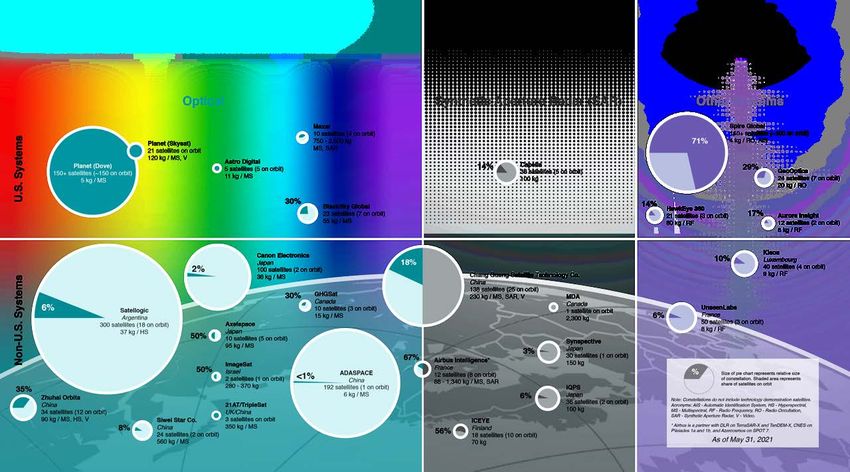
Bridging the digital divide
There are billions of people on Earth without reliable broadband. NGSOs will bridge the gap in places where service is
unreliable or expensive, or where it doesn’t exist at all.

1 billion
unserved households across the globe                                                      22%                         45%
                                                      17%
have no fixed broadband today (50% of
the global total).                                                              41M                         66M
                                                25M
                                                                                                  55%                                      53%
300 million                                                              78%
underserved households are on legacy      83%                                          9%
                                                                                                                                597M
technologies.
                                                                   61%
                                                                                          321M
100 million                                                                                                            47%
business, enterprise, and public sector                     118M
endpoints lack reliable connectivity.                                               91%
                                                  39%

                                                                          Number of unserved households per region

                                                                          Percentage of served fixed-broadband households (DSL, cable, fiber)
Source: S&P Market Intelligence
                                                                                                           3
                                                                          Percentage of unserved households within the region
                                                                                                                                                 3
Advantages of Low Earth Orbit
1                                       2                               3
Relative distance of satellites         Packet roundtrip time to        Customer Experiences
from Earth                              Internet
1x = 1,000 km                           Milliseconds
                                                                         Faster Web Pages
                            GEO = 35x
                                                              600-800    LEO loads Web Pages
                                                                           -similar to fiber
                                                                           -2x faster versus MEO
                                                                           -6-8x faster versus GEO
                      MEO = 8x
          LEO = 1x                                  125-250              Real-time over-the-top (OTT)
                                            30-50                        media applications

                                            LEO       MEO      GEO

 GEO = Geostationary Orbit
 MEO = Medium Earth Orbit
 LEO = Low Earth Orbit
                                                                                                        4
Satellites are an important part of communications ecosystem
   - provide a variety of mobile and
    fixed communications services

Image Credit: ESOA
                                                                 5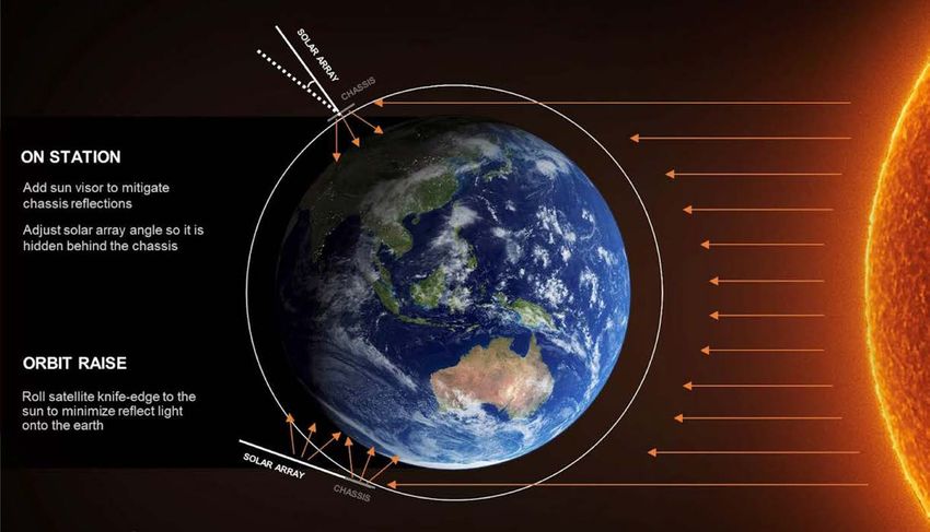
Challenges to Astronomy and Sustainability

Dark and Quiet Skies report:
     https://www.iau.org/static/publications/dqskies-book-29-12-20.pdf

COPUOS STSC Conference Room paper submitted by Chile, Ethiopia, Jordan, Slovakia,
Spain and the International Astronomical Union:
     https://www.iau.org/static/publications/uncopuos-stsc-crp-8jan2021.pdf
                                                                                    6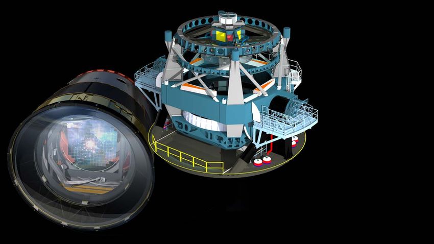
There is a proposed space population like we’ve never seen before!
              More than 50,000 new spacecraft proposed globally in next ten years

2018                                2021                                              2028

Images: Screen shots from animation based on applications filed with the ITU and the U.S. FCC. Credit SSC.   7
Rubin Observatory will execute the
Legacy Survey of Space and Time,
producing the deepest, widest, view of
our dynamic Universe:

§   8.4-m mirror
§   3200 megapixel camera
§   Each image the size of 40 full moons
§   Scans the sky with 2000 images per
    night
§   10 year survey of the sky 2024-2034
§   37 billion stars and galaxies
§   10 million alerts, 20 Terabytes of data -
    every night!
§   Significantly impacted by bright satellite
    trails
                                                 8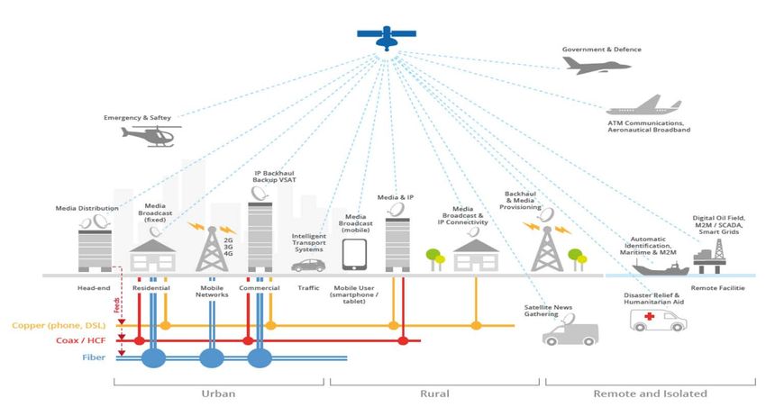
Two NGSO satellites
       in a 30 sec exposure

       2019-08-27

                                                                       Image on left taken with very
With tens of thousands of LEOsats, generally no combination of         small telescope with wide
mitigations can completely avoid the impacts of the satellite trails   field of view (above).

                                                                       John Tonry
Astronomical Journal, 160, 226 (2020)     arXiv:2006.12417             U Hawaii
                                                                                                       9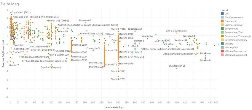
How do bright satellites affect observations on telescopes?

                                • Diversity of impact to radio
                                  astronomy, optical spectroscopy
                                  and imaging

                                Examples from imaging:
                                   •   Loss of information in pixels
                                   •   Cross-talk in electronics
                                   •   Ghost images
                                   •   Possible residual images
                                   •   Creates harmful artifacts

                                                                       10
Many factors contribute to overall scientific impact
Satellite Operator:
• Orbital altitude / dwell time of
Astronomers:
satellite in field of view (FOV)
• Telescope
• Constellation total number
• Camera detector properties
• Size of individual satellites
• Scheduling
• Reflectivity properties of material
• Field of View
• Geometry of reflected light
• Image sensitivity
• Orbit/De-orbit plans
• Post-processing algorithms
• Observational requirements
11 11Impact of Orbital Altitude
Summer at 30 deg latitude • Higher altitude constellations (1200 km) very
challenging – visible all night long during
Number satellites visible
summer.
120
100 • If constellation of 40,000 satellites deployed at
~1,200 km, then every 30 second exposure of
80 the Large Magellanic Cloud (LMC) will have at
60 least one satellite trail in it during summer.
40
20 • Orbits at 1,200 km may present challenge to 25
year de-orbit requirement and space debris /
proactive powered de-orbit capabilities are key
-1 0 1 2 3 4 5 6 7 8 9 10 • Critical to minimize number of non-operational
UT (hours) objects post-mission at all altitudes
10,000 satellites at 1000 km
Simulations by P. Seitzer (University of Michigan) – 100
10,000 satellites at 500 km planes with 100 satellites each, 53 deg inclination 12Studies and Workshops
13Cooperation, Coordination and Collaboration
• U.S. satellite industry has been closely cooperating with U.S. scientists, especially
at the Vera Rubin Observatory, a limiting case, to
• Understand the challenge to astronomy
• Satellite brightness (launch, mission, de-orbit phases)
• Numbers of satellites
• Satellite orbital altitude ( 1100 km)
• Quantify metrics for target goals
• For example, Astronomers have recommended that operators design satellites to
appear no brighter than approximately 7th magnitude.
• Find solutions
• We also emphasize the importance of international cooperation and
recognize the important role of the IAU and the satellite industry
internationally; Coordination discussions are ongoing . 147th magnitude brightness recommendation
Venus Hubble
(-4.2) Space
Telescope
Full Polaris
(31.5)
Moon (2.0) Rubin Obs
Sun in 10 s
(-13) Naked eye limit
(-26.7)
(6.5) (24)
-30 -25 -20 -15 -10 -5 0 5 10 15 20 25 30
Apparent magnitude
15 15Satellites in the 100+ kg range typically exceed the 7th
magnitude threshold for astronomers, but many smaller
sats do as well Interactive data:
https://public.tableau.com/app/profile/theres
e.jones/viz/DeltaMagvsmass/DeltaMag
Fainter than 7th Mag
100 kg Brighter than 7th Mag
Data source: Union of Concerned Scientists Satellite Database and MMT-9 Database
16Need to consider targeted stakeholder outreach in
determining mitigation mechanisms
• LEO comms satellites weighing 100s of kg largely exceed the practical brightness limit
• US companies launching thousands of satellites are working with astronomers, but astronomers need a
unified international effort
• Many new remote sensing constellations are in the ~100 kg range but launching constellations of tens of
satellites– at what point are they an issue for astronomy?
• Many smaller satellites also exceed the practical brightness limit
• Commercial remote sensing constellations weighing 10s of kg with hundreds of satellites– likely fainter but
may exceed the brightness limit
• Cubesats are not all below the brightness limit
Diverse set of stakeholders:
- Not all satellite operators manufacture their own satellites
- Smaller constellations may not be able to launch test satellites and make iterative changes
- Growing internationalization of satellite industry
- Decreasing costs (e.g., cubesats) means a lot of one-off projects
17U.S. Government Funded Workshops and Studies
• SATCON I and SATCON II -
• Hosted by NSF’s NOIRLab and the American Astronomical Society; we appreciated international participation!
• Four working groups: Observations, Algorithms, Community Engagement, Policy
• SATCON I: Mitigation recommendations that include quantitative metrics: https://aas.org/satellite-constellations-1-
workshop
• SATCON II: Define and quantify resources, metrics, and collaborations needed to implement recommendations;
• Engage astronomers and satellite operators collaboratively in exploring framework and developing policy
points for operations in LEO;
• Increase diversity of stakeholders and perspectives working to address the challenges and opportunities.
• Report forthcoming; public press conference available - https://www.youtube.com/watch?v=7DF99GIIR04
• JASON report
• Independent science advisory group
• Charged to understand
• Types and numbers of spacecraft planned in next decade;
• The current regulatory process;
• To characterize types of interference and types/range of observations being made and foreseen in the future; and
• Suggest additional data that should be gathered to understand the scope of the problem for the future.
• Report also considered long-term sustainability and space debris
• https://www.nsf.gov/news/special_reports/jasonreportconstellations/
• We look forward to participating in the Dark and Quiet Skies October 2021 Conference in the Canary Islands, Spain
18US Example from Industry
In May 2019, SpaceX’s inaugural launch of 60 Starlink satellites surprised optical astronomers with their
brightness
Since then, SpaceX has collaborated with astronomers in the US and internationally to assess the impact of
Starlink on astronomical observations, and to identify, develop, field and test mitigations. This work has
formed the foundation for many of the recommendations for satellite operators and astronomers
19SpaceX Goal for On-Station Brightness: Darken satellites so they do not saturate observatory detectors
MITIGATION: REDUCE REFLECTION DURING SUNSET AND SUNRISE
VIS
OR
SAT
DA
RKS
AT
SpaceX Goal During Orbit Raise: Make Satellites Invisible to Naked Eye within a Week After Launch
MITIGATION: CHANGE ORIENTATION TO REDUCE REFLECTION OFF BOTH ANTENNA AND SOLAR ARRAY
20Darkening Techniques are working and moving closer to target goal of 7th mag
21Protecting astronomical observations
Project Kuiper taking steps to minimize their impact on astronomical observations.
System design
• Project Kuiper operates at lower altitudes and includes fewer satellites, helping reduce
reflectivity compared to larger constellations or those operating at higher altitudes (over
1,000 km)
• As an all Ka-band system, we avoid potential interference issues with radio astronomy in
Ku-band.
Deployment and operations
• Maneuvering capabilities reduce earthward reflectivity during propulsive operations (orbit
raise and lower),
• Steering capabilities allow us to minimize reflections during mission operations.
Collaboration
• Amazon is committed to working with the astronomical community to find shared
solutions, and will share ephemeris data throughout operations to help protect and
preserve scientific research.
2223
Lessons Learned & Further Work

                                 24
Early solutions
• Some promising improvements from darkening or including visors to block
sunlight; when satellite operators implement technical upgrades with more
capable satellites, these should be considered.
• Work with industry to develop joint operations solutions to minimize science
impact including tools for efficient scheduling and predictive models.
• Develop observing strategies and new data analysis methods to partially
correct for statistical and systematic effects caused by satellite trails.
• Explore science impacts of residuals via end-end simulations.
However, even if mitigations work, evidence of satellite trails will clearly be in the data –
complicating data analysis, requiring longer science missions, limiting discoveries
25Further Work: Satellites and Telescopes
• More precise tracking information for satellites is needed to assist in astronomical observation planning
and development is needed in astronomical community to implement observation planning (although this
alone does not mitigate, especially for wide field-of-view astronomy telescopes like the Rubin
Observatory)
• Open Architecture Data Repository (OADR) in U.S. Department of Commerce a first step
• Tools used to model satellite brightness pre-launch as well as best practices for stakeholders across the
industry will be critical
• Additional basic research on materials/design may provide further guidance
• Development of software application available to general astronomy community to identify, model,
subtract, and mask satellite trails in images as well as detailed simulations of effects on data analysis
systematics and data reduction signal-to-noise impacts
• Collaboration and coordination with diversity of stakeholders
• Profile of space actors is rapidly changing– while communications satellites are the current focus of these
mitigation issues, remote sensing satellites are rapidly increasing in number on orbit
• Telescope technology is evolving and there are a diversity of observational parameters to consider
26Summary
The United States supports efforts to study these challenges and
encourages all administrations to carefully and thoughtfully consider
the individual recommendations within the Dark and Quiet Skies report.
International cooperation is required to agree on priorities and
accelerate practical, scalable solutions.
Astronomers and Satellite providers within the United States will
continue to work together and with the international community towards
a sustainable future – for the important provision of low-latency
broadband service, for future discoveries enabled by astronomy, for
long-term sustainability, and for society at large.
27Additional Reference Slides
Case Study: Remote Sensing Services
                    Commercial Remote Sensing Satellite Systems
               Systems with at least one operational satellite, by relative size of constellation, percentage of satellites on orbit, and sensor type

Prepared by:

                              Brycetech.com     703.647.8078   @BryceSpaceTech                 SIA.org     202.503.1560   @SIA_satellite
You can also read


